Exploring the cratered southern highlands of Mars, part 3
Overview map

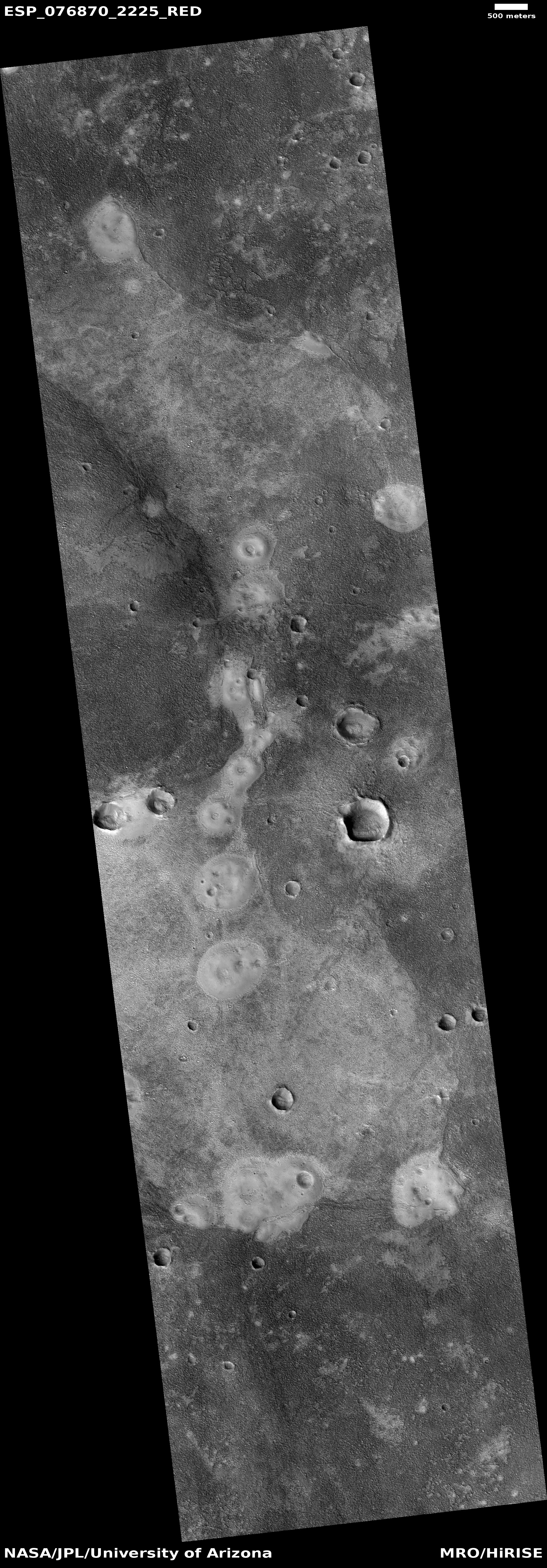
Pit and surface in crater
Click for original image.

This is the third part of this week’s series taking a look at some of the strange features in the southern cratered highlands of Mars. In the first part I posted a beautiful image of what appears to be a crater filled to the brim with glacial ice, surrounded by an ice sheet plain. In part two we took a look at the interior of Rabe Crater, which though very nearby does not appear to have obvious glacial features within it at all. What it has instead are deep open air pits and a lot of sand dunes.

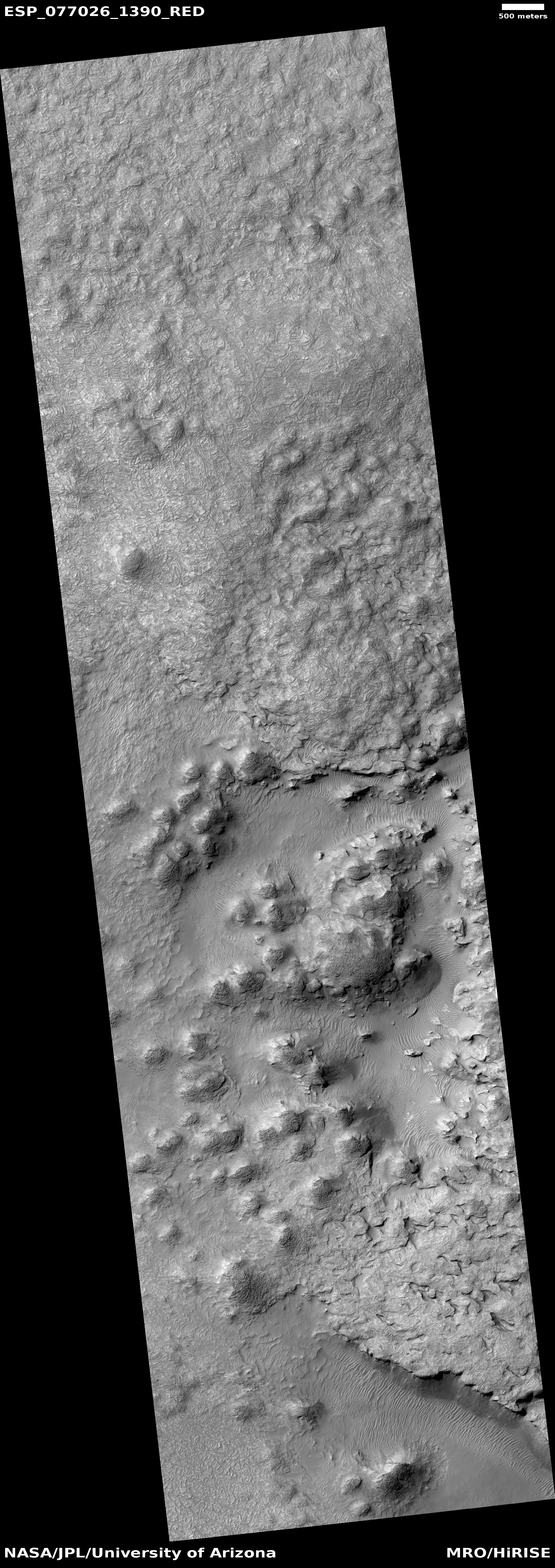
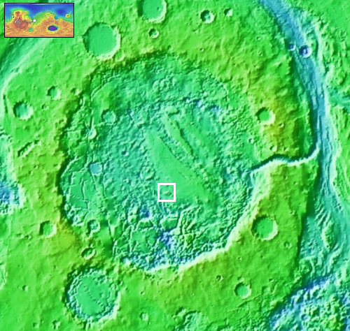
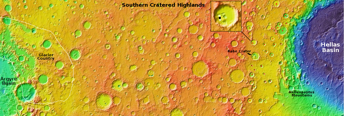
Today’s image to the right, cropped, reduced, and sharpened to post here, takes us to the interior of an unnamed 45-mile-wide crater only about 70 miles north of Rabe. The black dot in the inset on overview map above indicates the photo’s location. The picture was taken on January 1, 2023 by the high resolution camera on Mars Reconnaissance Orbiter (MRO). Like Rabe, this crater also has many large open-air pits. In the picture one pit, near the lower center of the picture, is surrounded by soft-looking mounds and a strangely swirling textured and uneven terrain that makes up the majority of the crater’s floor.

This picture might help explain what we saw in Rabe. The textured terrain in this unnamed crater could easily be ice-impregnated and now hardened sand dunes. The pit could be where that impregnated ice has sublimated away, leaving behind the dust from those ancient dunes which then forms new sand dunes. In Rabe, the crater floor above its pits looks very similar to this swirling textured surface, suggesting the same process is going on there.

What strengthens this explanation is the many other craters nearby, all indicated by red dots in the overview map above, that also have pits or distorted crater floors. Their proximity suggests that there is an underground ice layer in this region, always at about the same elevation, and each crater impact exposed it. With time that exposed ice, no longer pure but filled with material from the impacts, sublimated partly away, producing the pits as well as ample sand to form sand dunes.
0 comments

April 6, 2023 Quick space links

Courtesy of BtB’s stringer Jay.

  • China invites Brazil to participate in its lunar base project
  • There is no indication Brazil accepted the offer. The offer took place during a meeting between officials of the Brazil Space Agency and one of China’s pseudo-companies, China Great Wall Industry Corporation (which according to Jay “is the international launch service subsidiary” for China). Thus, this could be an effort by that pseudo-company to gain launch access to Brazil’s recently reactivated Alcรขntara spaceport.


1 comment

Exploring the cratered southern highlands of Mars, part 2

Overview map

Dune-bedrock contact in Rabe Crater
Click for original image.

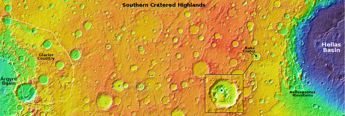
Our travels in the cratered southern highlands of Mars continues. Today we visit 67-mile-wide Rabe Crater, as indicated on the overview map above. The picture to the right, cropped and reduced to post here, was taken on January 27, 2023 by the high resolution camera on Mars Reconnaissance Orbiter (MRO).

Rabe Crater is significant for several reasons. First, it was one of the first places on Mars where sand dunes were identified, by one of the Viking orbiters in the late 1970s [pdf]. Second, the pits and sand in its interior, are unusual and puzzling. The inset on the overview map provides a closeup look at the crater. The yellow mound in the central south of the crater floor is all dunes, which are surrounded by the pit with steep cliffs more than a 1,000 feet high.
» Read more

1 comment

Exploring the cratered southern highlands of Mars, part 1

Overview map of southern cratered highlands of Mars

Glacial filled crater
Click for original image.

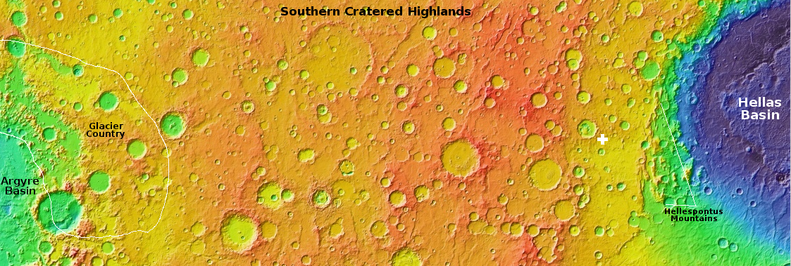
Today and for the next three days the cool images that I will post from Mars will explore a region that I have not covered very much in depth, the cratered southern highlands between the giant basins Argyre and Hellas. The map above is an overview of this 7,000-mile-long region, all of which is inside the 30 to 60 degree south latitude band where scientists have found much evidence of buried glaciers. In this region the bulk of that evidence is most obvious inside craters.

The picture to the right, cropped, reduced, and sharpened to post here, was taken on December 21, 2022 by the high resolution camera on Mars Reconnaissance Orbiter (MRO), and shows a typical example of the kind of glacial feature found. The white cross on the map marks its location, west of the Hellespontus Mountains that form the western rim of Hellas Basin.

Scientists have dubbed this feature concentric crater fill, a purposely vague term because — though it looks like glacial fill — until there is data to confirm it the scientists would quite properly rather not commit themselves. The concentric rings suggest multiple layers, each of which likely marks a different climate cycle in Mars’ geological history.

In this case the glacier features also appear to cover the entire plain surrounding the crater as well as its rim. The small crater to the west is similar, and both give the appearance that the ice sheet that covers them came after the impact, draping itself over everything, with the craters only visible because the ice sheet sags within their interiors.

More crazy features from the cratered highlands to come.

0 comments

The outermost edge of Mars’ north polar icecap

The outermost edge of Mars' north polar icecap
Click for original image.

Cool image time! The picture to the right, rotated, cropped, reduced, and sharpened to post here, was taken on February 4, 2023 by the high resolution camera on Mars Reconnaissance Orbiter (MRO). It shows the terminating cliffs of the north pole ice cap of Mars, dubbed Rupes Tenius on this side of the icecap.

At this point the elevation difference of the icecap’s edge from top to bottom is not significant, only about 1,500 feet or so, though this is a very rough estimate. As with all other images of the ice cape’s edge, there are many many layers visible, all indicating a different cycle in the climate history of Mars as its rotational tilt swings from about 11 degrees to 60 degrees over eons.

Moreover, at this point there is likely not that much difference between the terrain on top and the terrain below. Both will be mixed ice and dust and coarse rocks, though the percentages will be shifting towards less ice as we go down.
» Read more

1 comment

A journey into Martian chaos

Overview map of Aram Chaos

With today’s cool image, we shall begin with the overview map, and drill our way down until we get a close look at another example of truly alien Martian terrain, with only a hint of similarity to comparable geology on Earth.

The overview map to the right shows us Aram Chaos, an ancient 170-mile-wide impact crater that has gone through such complex geology that it is difficult, maybe impossible, to unravel it based on data obtained from orbit. As I wrote in a detailed December 2020 post describing the confusing geology of this crater,

The floor of Aram Chaos is a place of great puzzlement to planetary geologists. The geology there is incredibly complex, and includes chaos terrain overlain by several sedimentary layers of sulfate minerals. The chaos terrain is most obvious in the southern part of the crater’s floor. The flat areas near the eastern center are those overlaying sedimentary layers.

When we zoom into the white box we can see a good example of this complexity.
» Read more

0 comments

Ingenuity completes 49th flight on Mars

Overview map
Click for interactive map.

The Ingenuity team today posted the official flight totals for the Mars helicopter’s 49th flight, which took place yesterday.

The helicopter flew 925 feet for 143 seconds, or two minutes and twenty-three seconds. The plan had been to fly 894 feet for 135 seconds, but has been happening consistently for the past dozen or so flights, the helicopter spent a little more time in the air and traveled a little farther.

As for altitude, it apparently did exactly as planned, averaging about 40 feet in height until the end of the mission, when Ingenuity went straight up another twelve feet to get a wider view of its landing area.

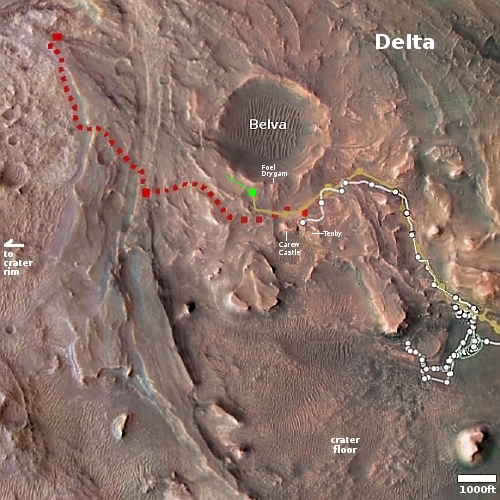
The map to the right shows the context. The green dot marks Ingenuity’s location at the start of the flight. The green line indicates my approximate estimate of its flight path and landing area, which the engineering team has not yet posted. The white dots and line mark Perseverance’s path, with its present location at the area dubbed Tenby where it has obtained its first core sample from the top of the delta.

1 comment

Sponge terrain on Mars

Sponge terrain on Mars
Click for original image.

Cool image time! The picture to the right, rotated, cropped, reduced, and sharpened to post here, was taken on January 11, 2023 by the high resolution camera on Mars Reconnaissnace Orbiter (MRO).

The scientists labeled this picture “Rocky Terrain.” Though this describes the overall sense of the full image, it fails to capture correctly the nature of this patch of ground at the center of the picture. As you can see, this patch of spongelike surface starts and ends abruptly. It appears that it is a layer on top of the surrounding terrain that has also been eroded aggressively since its placement.

The many craters on its surface seem to have come later, though as the crater size diminishes it becomes harder to separate the craters from the sponge holes. Moreover, some of the larger craters are distorted in shape, as if the impact hit material that was viscous and could flow somewhat.

The overview map below gives some context, but only some.
» Read more

3 comments

A bubbly cauldron on the surface of Mars

A bubbly cauldron on the surface of Mars
Click for original image.

Cool image time! The picture to the right, rotated, cropped, reduced, and sharpened to post here, was taken on December 20, 2022 by the high resolution camera on Mars Reconnaissance Orbiter (MRO). It shows a strange terrain of craters and mounds, with all the mounds having pits within them like volcanic calderas. In between the surface has a two-toned stippled look, as if two different materials are in the process of mixing.

My immediate impression was that of the bubbly surface of a vat of tomato sauce simmering. Or maybe the vile mixture created by the witches in Shakespeare’s Macbeth, which as they mix they chant:

First witch:
Round about the cauldron go;
In the poison’d entrails throw.
Toad, that under cold stone
Days and nights has thirty-one
Swelter’d venom sleeping got,
Boil thou first i’ the charmed pot.

ALL:
Double, double toil and trouble;
Fire burn, and cauldron bubble.

Of course, this is not a vat of witch’s brew or tomato sauce. It is the surface of the planet Mars, but an alien surface nonetheless.
» Read more

0 comments

Psyche asteroid mission now scheduled for October 2023 launch

After a year delay because certain flight software was not ready on time for its first launch window in the fall of 2022, the science team for the Psyche asteroid mission are now aiming for an October 2023 launch.

The launch period will open Oct. 5 and close Oct. 25. The asteroid, which lies in the outer portion of the main asteroid belt between Mars and Jupiter, may be the remains of a core of a planetesimal, a building block of a rocky planet.

Due to the new launch date, Psyche has a new mission plan, which includes a flyby of Mars for a gravity assist and arrival at the asteroid in August 2029. The mission then will enter its 26-month science phase, collecting observations and data as the spacecraft orbits the asteroid at different altitudes.

Meanwhile, the two Janus probes that were to launch with Psyche last year remain in limbo, as this new Psyche launch date is useless to that mission’s plan to fly past a different asteroid.

1 comment

The chaos between galaxies following their head-on collision

The chaos between galaxies following their head-on collision
Click for original image.

Cool image time! The picture to the right, cropped, reduced, and sharpened to post here, was taken using the Gemini North ground-based 8-meter telescope in Hawaii. It shows two spiral galaxies about 180 million light years away following a head-on collision about 25 million years ago, in which the smaller spiral moved through the larger from the bottom to the top.

Upon exiting, the smaller spiral trailed behind it the reddish stream of material, while its outside arms on the right were bent downward. That trailing material is why astronomers have dubbed these the “Taffy Galaxies.” Imagine pulling two clumps of taffy apart. The stretched material linking the two clumps is the bridge of trailing material between these two galaxies. From the caption:

When the Taffy Galaxiesโ€™ collided, their galactic disks and gaseous components smashed right into each other. This resulted in a massive injection of energy into the gas, causing it to become highly turbulent. As the pair emerged from their collision, high-velocity gas was pulled from each galaxy, creating a massive gas bridge between them. The turbulence of the stellar material throughout the bridge is now prohibiting the collection and compression of gas that are required to form new stars.

The evolution of galaxies is incredibly slow, from the perspective of human existence. For example, this first collision 25 million years ago seems like it took a long time, but it will likely be followed by many more over the next billion years, eventually resulting in a single spherical elliptical galaxy. On the time scale of the universe, collisions every 100 million years or so means galaxies like this can mix and collide many times, and do so well within the existence of the theorized lifespan of the universe itself.

To us short-lived humans, however, this process just seems so slow it can’t possibly happen as described. But it does.

Sidebar: It appears this image was released to herald the repair of Gemini North’s primary mirror, which was damaged in two places on its edge during a recoating operation on October 20, 2022. Since then the telescope has been shut down as repair operations were undertaken. That repair is now complete, and it is expected the telescope will resume science observations in a few weeks.

2 comments

Zhurong: Small polygons on light curved dunes indicate regular atmospheric water interaction

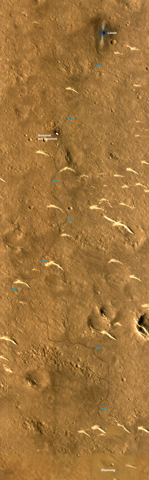
Zhurong's full journey on Mars

A paper published this week in Geophysical Research Letters by the science team for China Zhurong Martian rover has revealed the discovery of small polygon cracks on the surface of the many curved light-colored small dunes found in the region where Zhurong landed, suggesting the possibility of relatively recent water activity between the atmosphere and the dune surfaces.

Those dunes, dubbed transverse aeolian ridges (TARs) by the science team, are the many light curves visible in the labeled Mars Reconnaissance mosaic to the right. The blue arrows indicate Zhurong’s path south from its landing spot at the top and ending near the bottom of the picture after traveling about 1,400 feet.

According to the paper, the TARs were formed by the prevailing winds over many eons, coming first from the north and then from the northwest. The edges of the ridges, being smaller, are pushed ahead quicker, thus creating the curved shape. The polygons were small, never larger than 4 inches in size, with five to six sides. The scientists theorize that they were formed when atmospheric water interacted with the dune crust, causing fractures “due to temperature/moisture changes or deliquescence/dehydration cycling of salts”. This process could be slow or fast, and could actually be occurring in relatively recent times, as the scientists say it requires only a little water in the atmosphere.

More likely however we are seeing evidence of water from the past, from tens of thousands to several million years ago.

Zhurong meanwhile remains in hibernation, and might never come out of that condition. Orbital images indicate that its solar panels are dust-covered, the result of the heavy winter dust storm season. The project team however is hopeful that with time and the arrival of Martian summer the dust will be blown off and they can reactivate the rover. This hope however entirely depends on the arrival of a dust devil acoss the top of Zhurong, a random event that cannot be predicted. With both the Spirit and Opportunity rovers, such events happened regularly, allowing those missions to last years instead of only 90 days. With InSight it never happened, and the lander died after two-plus years on Mars.

Zhurong’s future fate thus remains unknown, but not promising at this moment.

0 comments
1 73 74 75 76 77 89