New map of the volcanoes of Venus

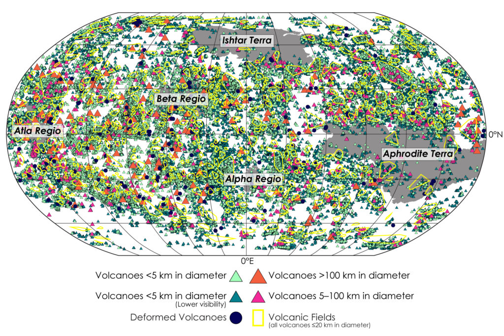
Map of Venus' volcanoes
Click for original image.

Using the archival radar data from the Magellan orbiter that circled Venus in the early 1990s, scientists have produced a new map of the volcanoes of Venus.

That map is to the right, and is publicly available for download.

Byrne and Hahn’s new study includes detailed analyses of where volcanoes are, where and how they’re clustered, and how their spatial distributions compare with geophysical properties of the planet such as crustal thickness. Taken together, this work provides the most comprehensive understanding of Venus’ volcanic properties — and perhaps of any world’s volcanism so far … because, although we know a great deal about the volcanoes on Earth that are on land, there are still likely a great many yet to be discovered under the oceans. Lacking oceans of its own, Venus’ entire surface can be viewed with Magellan radar imagery.

Although there are volcanoes across almost the entire surface of Venus, the scientists found relatively fewer volcanoes in the 20-100 km diameter range, which may be a function of magma availability and eruption rate, they surmise.

This new map catalogs about 85,000 volcanoes, but is also considered incomplete because the resolution of the Magellan data makes identifying volcanoes smaller than 1 kilometer impossible. It will require new orbiters to spot these volcanoes.
0 comments

Looking back from the foothills of Mount Sharp

Panorama looking back across Gale Crater, March 29, 2023
Click for original image.

Overview map
Click for interactive map.

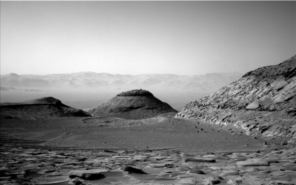
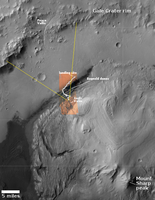
The panorama above, cropped to post here, was taken today by the left navigation camera on the Mars rover Curiosity. It looks back at the rover’s previous travels, though only the terrain traveled in the past few months is visible, the rover having reached this point through the notch to the left of the distinctly dark mesa in the center of the picture. The lower flanks of Mount Sharp the rover traversed to get here are now blocked from view.

Instead, the image provides a spectacular example of the views north from Curiosity’s present position. The overview map to the right provides us the full context of the entire ten-plus year journey since Curiosity landed safely on Mars on August 5, 2012. The white squiggly line indicates the rover’s route. The yellow lines mark the approximate area covered by the panorama. The rim of Gale Crater is about 20-25 miles away.

As you can see, as spectacular as this view is, the journey up Mount Sharp has barely begun. Mount Sharp’s peak is about 18,000 feet high. The rover at this point has only climbed about 4,600 feet from the floor of Gale Crater.

0 comments

Hakuto-R1 snaps first picture of Moon from lunar orbit

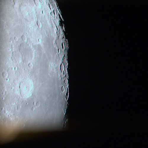
Hakuto-R1's first released image from lunar orbit
Click for original image.

The science team for Ispace’s Hakuto-R1 privately-built lunar orbiter/lander earlier this week released the spacecraft’s first picture of the Moon since entering lunar orbit on March 20, 2023.

That image is to the right, cropped and reduced to post here. The photo resolution is quite good. It also demonstrates that the spacecraft’s attitude control systems for pointing the camera are working correctly.

Launched on December 11, 2022 by a Falcon 9 rocket, Hakuto-R1 will land in Atlas Crater on the northeast quadrant of the Moon’s visible hemisphere sometime in April, making it the first successful private commercial planetary lander to reach another world. If successful, it will then release the United Arab Emirates Rashid rover, that nation’s first planetary lander but its second planetary mission, following the Mars orbiter, Al-Amal, now circling Mars.

6 comments

Mars’ largest mountain region

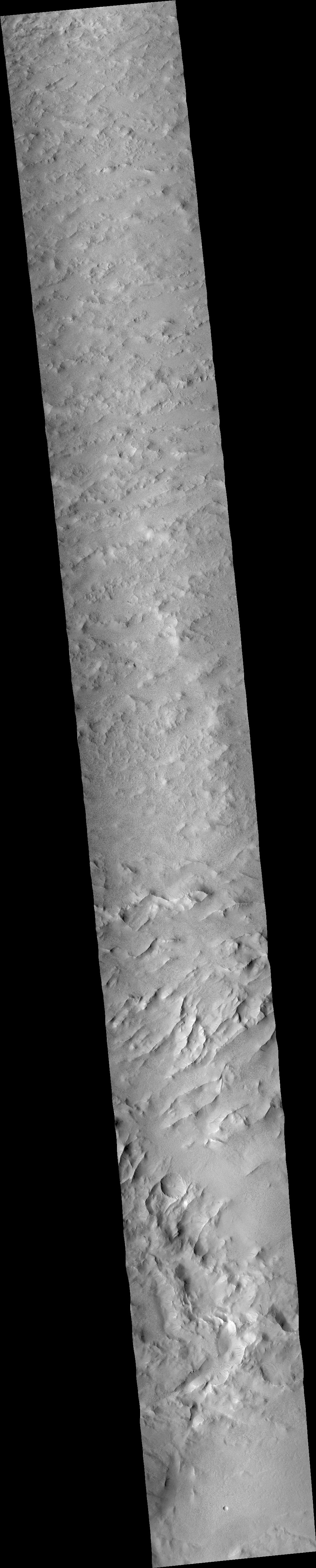
Mars' largest mountain region
Click for original image.

The picture to the right, rotated, cropped, reduced, and enhanced to post here, was taken on September 21, 2015 by the context camera on Mars Reconnaissance Orbiter (MRO). I originally was going to post a high resolution image of some of these mountains, taken on January 1, 2023 that showed some slope streaks, but quickly realized that a wider view of this mountain region was a much more interesting story.

This picture covers an area about 50 by 50 miles. As you can see, it is endless series of random hills ridges and peaks, with only a vague hint of a northeast to southwest alignment. Ground travel through this region would be slow and twisty, immediately reminding me of my many trips to West Virginia, where the hills and valleys are almost as random and never ending.

The overview map below however suggests the scale of this region exceeds West Virginia many times over.
» Read more

0 comments

Scientists detect water inside lunar samples returned to Earth by Chang’e-5

Chinese scientists have found water molecules trapped within glass beads found within the lunar samples returned to Earth by the lunar lander Chang’e-5.

The team polished and analysed 117 glass beads which were scooped up by China’s Chang’e-5 spacecraft in December 2020 and brought back to Earth. The beads are formed by tiny meteorites that bombard the surface of the Moon, which lacks the protection of an atmosphere. The heat of the impact melts the surface material, which cools into round glass beads around the width of a strand of hair.

…The glass beads may make up around three to five percent of lunar soil, according to the study. A “back of the envelope” calculation suggested that there could be around a third of a trillion tonnes of water inside all the Moon’s glass beads, he added. And it only takes mild heat of around 100 degrees Celsius (210 Fahrenheit) to liberate the water from the beads, Anand said.

According to the paper, the water’s origin might be tied to the solar wind, and might have been implanted in the beads after their impact formation.

If this analysis is correct, it might explain the hydrogen signature found in large parts of the lunar surface, where it is believed water simply couldn’t exist. It also might explain why the first images inside permanently shadowed lunar craters show no obvious ice, only what appear to be ponds of dark dust. The dust might contain these beads, and thus explain the hydrogen signature detected there as well.

0 comments

A Martian crater with a surface pattern that resembles hanging draperies

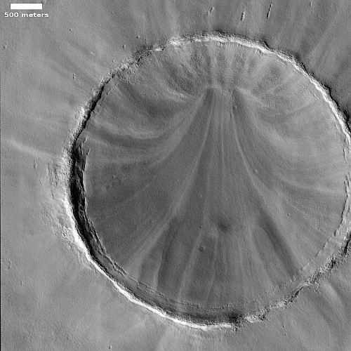
A Martian crater with a surface pattern like hanging draperies

Cool image time! The picture to the right, rotated, cropped, reduced, and enhanced to post here, was taken on January 27, 2023 by the high resolution camera on Mars Reconnaissance Orbiter (MRO), and shows what the scientists label a “streak-spoke pattern” inside the crater. To my eye, the pattern more resembles hanging draperies, neatly tied near the top and then pulled apart as they descend to the ground.

This photo was a follow-up to a previous picture by MRO on February 4, 2008, more than seven Martian years ago, to see if there had been any identifiable changes in that time. Both images were taken in springtime, and despite the passage of time, the 2023 image shows no obvious changes from the 2008 photo.

What caused this distinct pattern? The first guess would be the wind, except if so shouldn’t there have been some change over seven Martian years?
» Read more

1 comment

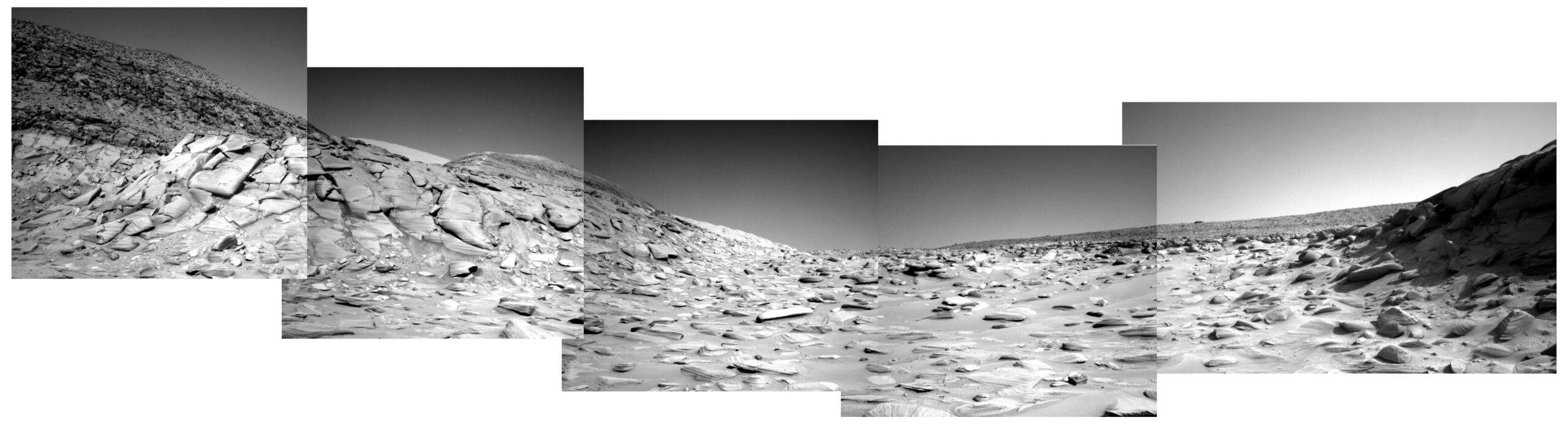
Curiosity heads to the west of the Hill of Pillows

Panorama on March 27, 2023 (Sol 3781)
Click for full resolution panorama. The original images can be found here, here, here, here, and here.

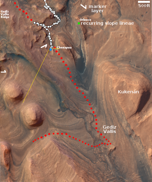
Overview map
Click for interactive map.

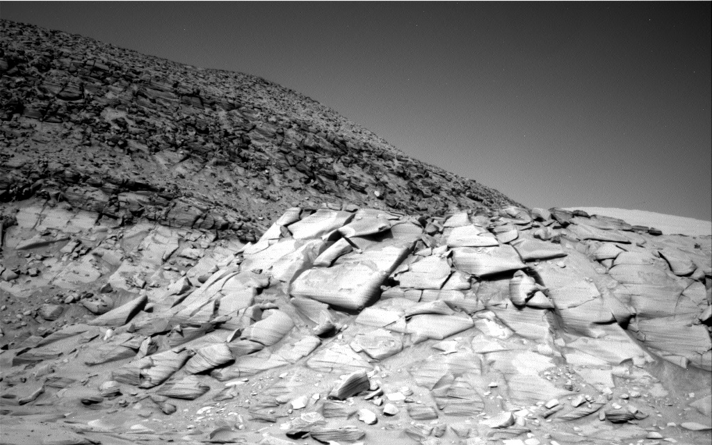
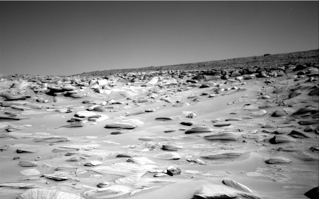
In my previous post on March 11, 2023 showing Curiosity’s spectacular view at that time in the foothills of Mount Sharp, the main question was: Which route will the rover take in the next few weeks? Based on the panorama above, created from five pictures taken by Curiosity’s right navigation camera today, it now appears that the science team has made its decision and will have the rover traverse to the west of what I label the Hill of Pillows.

The overview map to the right gives the context. The blue dot marks Curiosity’s position three days ago, with the yellow lines indicating the approximate area covered by the panorama. The red dotted line shows the planned route going past the Hill of Pillows to the east.

The science team took a careful look at the terrain in both directions, and decided the route to the west was both more gradual and less rough. This set of images by the navigation camera was now taken to better plan the route up in this hollow among its rock-strewn ground.

Make sure you look at the full resolution version of the panorama. You can see on the horizon the high mesas in the south just beginning to appear.

0 comments

Ancient Martian landslides

Ancient Martian landslides
Click for original image.

Cool image time! The picture to the right, rotated, cropped, reduced, and sharpened to post here, was taken on December 23, 2022 by the high resolution camera on Mars Reconnaissance Orbiter (MRO). The image was labeled “Landslides in Orson Welles Crater” because the full photo shows at least two large and obvious slides, with the biggest shown to the right.

These avalanches are likely ancient because both have craters on them suggesting the material has not moved for a very long time. Yet when both flowed they did so almost like mud, the material moving downhill almost in a single blobby mass. Both have this look, as do many Martian landslides, which I think is why the scientists usually label them mass wasting events.
» Read more

0 comments

Hubble spots long term seasonal changes on Uranus

Uranus as seen by Hubble in 2014 and 2022
Click for original image.

Using images of Uranus taken eight years apart by the Hubble Space Telescope, astronomers have detected significant seasonal changes in the atmosphere of the gas giant, caused by its unusual sideways rotation.

The two pictures to the left, realigned and reduced to post here, show the changes. If you look closely you can see the planet’s ring system and its shift to almost face on at present.

[top] — This is a Hubble view of Uranus taken in 2014, seven years after northern spring equinox when the Sun was shining directly over the planet’s equator, and shows one of the first images from the OPAL program. Multiple storms with methane ice-crystal clouds appear at mid-northern latitudes above the planet’s cyan-tinted lower atmosphere. Hubble photographed the ring system edge-on in 2007, but the rings are seen starting to open up seven years later in this view. At this time, the planet had multiple small storms and even some faint cloud bands.

[bottom] — As seen in 2022, Uranus’ north pole shows a thickened photochemical haze that looks similar to the smog over cities. Several little storms can be seen near the edge of the polar haze boundary. Hubble has been tracking the size and brightness of the north polar cap and it continues to get brighter year after year. Astronomers are disentangling multiple effects – from atmospheric circulation, particle properties, and chemical processes – that control how the atmospheric polar cap changes with the seasons. At the Uranian equinox in 2007, neither pole was particularly bright.

To really understand the long term climate of Uranus will likely take centuries, since its year lasts 84 Earth years. Since the beginning of space exploration, we have only had now about forty years of good imagery of the planet, and even that has been sporadic and very incomplete.

8 comments

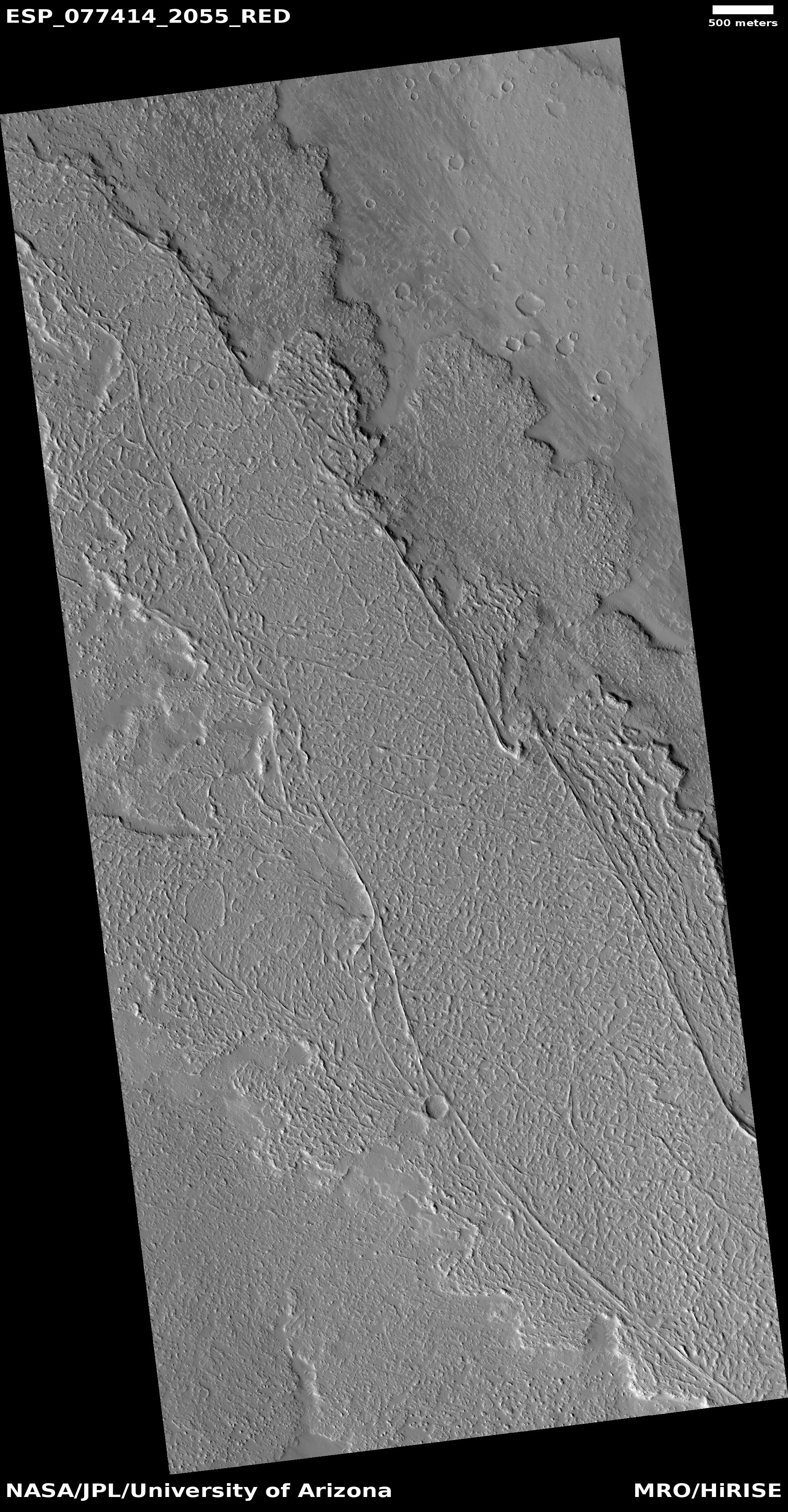
Where the flood lava of two gigantic Martian volcanoes meet

Where the flood lava of two gigantic Martian volcanoes meet
Click for original image.

Today’s cool image illustrates once again the importance of looking not simply at the picture but at the surrounding larger context in order to understand the Martian features within the photograph.

The photo to the left, cropped, reduced, and sharpened to post here, was taken on January 31, 2023 by the high resolution camera on Mars Reconnaissance Orbiter (MRO). The location is at 26 north latitude, so it is in the dry equatorial regions. It shows what appears to be a large Martian flood lava plain, with at least two different flood lava events appearing to flow to the northeast, with the second only partly covering the first.

From this high resolution image it seemed probable that the source of the flow was from the southwest, an assumption that at first glance is strengthened by the overview map below.
» Read more

0 comments

Confused glaciers in a Martian crater

Confused glaciers in a Martian crater
Click for original image.

Cool image time. The picture to the right, cropped to post here, was taken on February 2, 2023 by the high resolution camera on Mars Reconnaissance Orbiter (MRO), and shows a strangely blobby crater in the northern mid-latitudes where glacial features are frequently found inside craters.

In this case however the glacier seems very confused. As this is in the northern hemisphere, you would expect glacial material to survive on the north-facing southern interior slopes of the crater, where there is year-round less sunlight. The mottled eroded terrain in the south part of the crater floor suggests this. However, the crater also clearly has a terraced glacier on its south-facing northern interior slopes.

Why has the glacial material survived in both places, but not in the center of the crater?

In addition, there is that strange roughly circular feature attached to the south side of the crater. What formed it? Is it a glacier on the plains surrounding the crater? Or are we looking at volcanic material?

This crater is also unique. The crater just to its southwest (partly seen in the cropped image above), is a much more typical glacial-filled mid-latitude crater, its interior material more evenly distributed and its circular rim only slightly distorted.
» Read more

0 comments

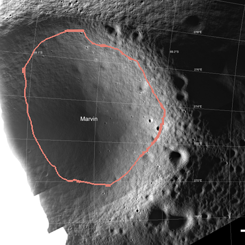
No ice inside permanently shadowed crater near Moon’s south pole?

Marvin crater as seen by Shadowcam
Click for original image.

Overview map

Using a camera on South Korea’s lunar orbiter Danuri, dubbed Shadowcam and designed to look into the permanently shadowed craters at the Moon’s poles, scientists have taken an image that sees into the forever dark region of one such crater.

The picture to the right, released on March 13, 2023 by the Shadowcam science team, is of the crater Marvin, located about 16 miles to the east of the south pole. The pink outline indicates the area that is thought to be permanently shadowed.

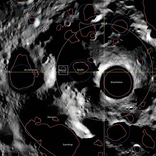
The second image to the right provides a wider view of the south pole region, with the craters labeled and outlined by the green lines. The orange lines mark permanently shadowed areas. The white box indicates the approximate area covered by the Shadowcam picture. One of the candidate landing sites for Starship, as part of NASA’s Artemis program, is the eastern rim of Shackleton, essentially at the south pole itself.

Previous data suggests that ice should be found in those permanently shadowed areas, because other orbiters have detected evidence of hydrogen there. The Shadowcam picture above however shows nothing that strongly suggests the presence of ice, unless that darker flat area on the floor of the crater is ice-infused dust. If so however, it is quite ancient and solid, based on the presence of several craters within it.

The press release makes no mention of this question, probably because the scientists are still analyzing the data. This first look however suggests the ice is not there, or is in a form that is going to require a lot of processing to extract the water from it.

1 comment
1 74 75 76 77 78 89