Dimorphus is dry, based on data obtained before and after DART hit it

Data collected by the ground-based Very Large Telescope (VLT) in Chile before and after the impact by the DART probe in September 2022 has revealed that the rubble-pile asteroid Dimorphos is very dry, with little or no water.

[The astronomers] observed the Didymos–Dimorphos system on 11 occasions, from just before the impact to about a month afterwards. MUSE [one of VLT’s instruments] is able to split the light from the double-asteroid into a spectrum, or rainbow, of colors, to look for emission at specific wavelengths that corresponds to specific molecules. In particular, Opitom’s team searched the ejecta for water molecules and for oxygen that could have come from the break-up of water molecules by the impact. However, no evidence of water was detected. Dimorphos, at least, seems to be a dry asteroid.

You can read the paper here.

Some theories prior to DART’s impact suggested that there could be ice within some inner solar system asteroids. Finding none instead suggests that inner solar system asteroids are very distinct and different from the icy comets and asteroids either coming from or orbiting in the outer solar system.

0 comments

A half-mile high Martian cliff on the verge of collapse

A half-mile Martian cliff on the verge of collapse
Click for original image.

Cool image time! The picture to the right, cropped and reduced to post here, was taken on December 24, 2022 by the high resolution camera on Mars Reconnaissance Orbiter (MRO). It shows erosion gullies coming down off a mountain side, just north of a massive cliff that I estimate to be around 2,000 to 3,000 feet high.

Note the north-south-trending cracks. These suggest that this entire half-mile-high cliff face is slumping downward, cracking as it does so. The cracks at the start of the high flat-topped thumb-shaped mesa near the image bottom are especially intriguing. They suggest that this entire mesa might eventually separate and give way.

There is a specific reason this cliff face is slumping, as shown in the overview map below.
» Read more

12 comments

A verde valley on Mars

A verde valley on Mars
Click for original image.

In the southwest where I live, a valley dubbed “verde” (which means “green” in Spanish) is generally a place with a somewhat persistent river with lots of lush plant life. The Verde Valley in Arizona is the perfect example, with “close to 80% of the valley’s land … national forest.”

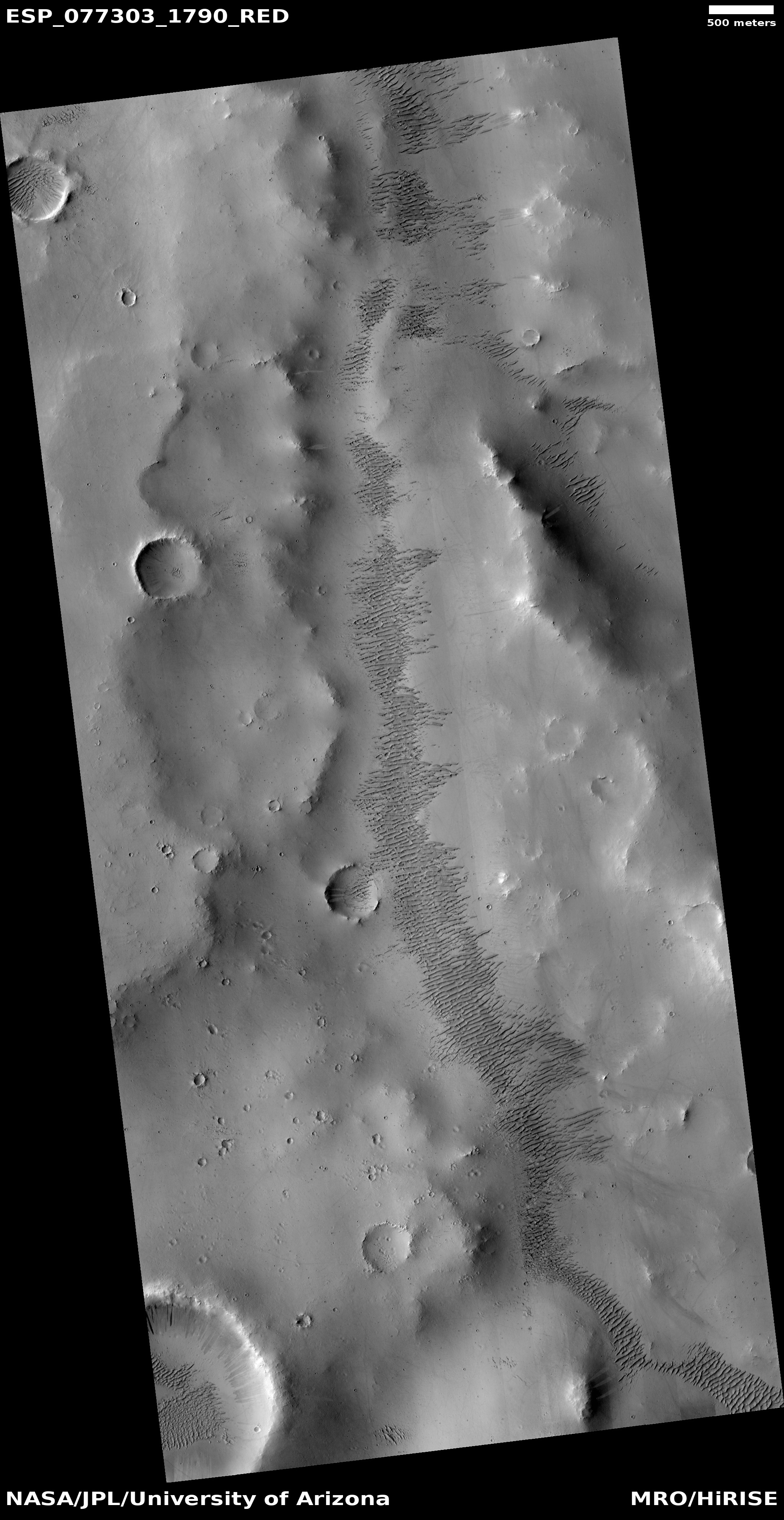
On Mars there is also a verde valley, but the name is not descriptive in the least. The picture to the right, rotated, cropped, and reduced to post here, was taken on January 22, 2023 by the high resolution camera on Mars Reconnaissance Orbiter (MRO) and shows one section of the Martian Verde Vallis, draining south to north.

The dark rippled patches inside this shallow canyon are sand dunes. In fact, though MRO has not taken many high resolution images of Verde Vallis, every one shows the valley with further patches of ripple dunes. See for example this image of a section of the valley just a bit farther north.
» Read more

2 comments

The ubiquitous presence of ice in the Martian mid-latitudes

Ice in the Martian mid-latitudes
Click for original image.

Cool image time! The picture to the right, rotated, cropped, rotated, and sharpened to post here, was taken on November 28, 2022 by the high resolution camera on Mars Reconnaissance Orbiter (MRO). Labeled merely as a “crater with mesa”, it gives us another example of the presence of glacial ice in the mid-latitudes of Mars.

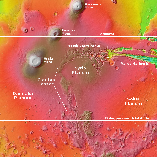
That mesa is what planetary scientists have labeled “concentric crater fill,” a glacial feature found in numerous craters throughout the mid-latitude bands from 30 to 60 degrees latitude. The ground in the terrain surrounding the crater could be also be impregnated with ice, but based on the location as shown in the overview map below, it is just as likely to be lava.

In fact, the location of this particular crater illustrates why concentric crater fill might become the best source of ice for future colonists.
» Read more

0 comments

Endless ripple dunes in Mars’ third largest impact basin

Ripple dunes in Mars' third biggest impact basin
Click for original image.

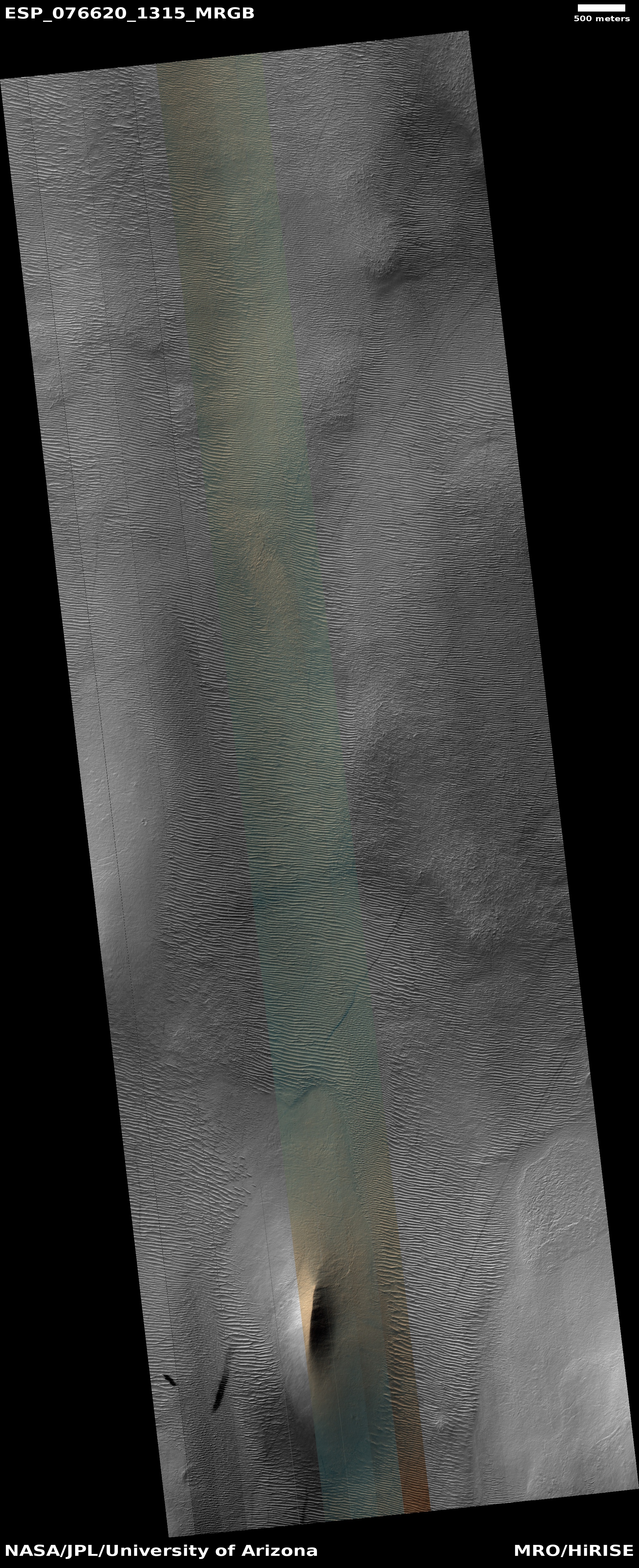
Cool image time! The picture to the right, cropped to post here, was taken on November 30, 2022 by the high resolution camera on Mars Reconnaissance Orbiter (MRO).

The section cropped shows only a small portion of the endless ripple dunes seen in this area. The color strip provides us some interesting other details as well as mysteries. The orange indicates dust on the ridges as well as the higher terrain near the center of the picture. The green in the hollows as well as to the east and west suggests coarser materials that have settled in lower elevations. This supposition is reinforced by the orange area near the bottom of the picture where the ripples have mostly dissipated. This is a high spot, and we appear to be looking at a dusty surface. (This impression is clearer in the full image.)

The latitude is high, 48 degrees south, but as far as I know orbital images have not found a lot of ice evidence in this part of Mars.
» Read more

0 comments

Another study finds evidence of active volcanism on Venus

Changes in volcanic vent on Venus over eight months
Click for original image.

Using archival data from the Magellan spacecraft that orbited Venus in the early 1990s scientists think they have identified an active vent that appeared to change shape based on radar images taken eight months apart.

From the abstract of their paper:

We examine volcanic areas on Venus that were imaged two or three times by Magellan and identify a ~2.2 km2 volcanic vent that changed shape in the eight months between two radar images. Additional volcanic flows downhill from the vent are visible in the second epoch images, though we cannot rule out that they were present but invisible in the first epoch due to differences in imaging geometry. We interpret these results as ongoing volcanic activity on Venus.

This result is different that other research released last month that used Magellan data to identify geological features on Venus most likely to be active. In today’s results the scientists think they have spotted an actual volcanic eruption, as shown in the two images to the right. The image is taken from Figure 2 of the paper, with the changes in the center bottom vent clearly visible.

There is much uncertainty in these results that must be mentioned. The images are not optical but radar, so the scientists had to do a lot of computer processing to get the final result. They also compared this work with computer simulations to help confirm their conclusions.

The results also leave open the question of the total amount of volcanism presently active on Venus. As the scientists note in their conclusion, “With only one changed feature, we cannot determine how common currently active volcanism is on Venus.”

Nonetheless, the research using both new and archival data in the past thirty years is increasingly telling us that there is some active volcanism on Venus, hidden beneath its thick hellish cloudy atmosphere.

2 comments

Geological evidence of past glacier found in Mars’ dry equatorial regions

Overview map

Scientists have uncovered geological evidence of a past glacier in westernmost end of the giant Martian canyon Valles Marineris, right at the point where it transitions into the complex chaos region dubbed Noctis Labyrinthus. The white dot on the map to the right indicates the location.

The surface feature identified as a “relict glacier” is one of many light-toned deposits (LTDs) found in the region. Typically, LTDs consist mainly of light-colored sulfate salts, but this deposit also shows many of the features of a glacier, including crevasse fields and moraine bands. The glacier is estimated to be 6 kilometers long and up to 4 kilometers wide, with a surface elevation ranging from +1.3 to +1.7 kilometers. This discovery suggests that Mars’ recent history may have been more watery than previously thought, which could have implications for understanding the planet’s habitability.

What we’ve found is not ice, but a salt deposit with the detailed morphologic features of a glacier. What we think happened here is that salt formed on top of a glacier while preserving the shape of the ice below, down to details like crevasse fields and moraine bands,” said Dr. Pascal Lee, a planetary scientist with the SETI Institute and the Mars Institute, and the lead author of the study. [emphasis mine]

You can read the paper here [pdf]. The research specifically suggests that near surface water ice in the dry equatorial regions of Mars could have been there much more recently that previously believed. It also suggests, by the rarity of this discovery, that there is likely almost no near surface ice in the equatorial regions, at present.

1 comment

Firefly wins its second NASA contract to land payloads on the Moon

Capitalism in space: Firefly announced today that it has won a $112 million NASA contract to use its Blue Ghost lunar lander to bring three instruments to the Moon, one into orbit and two on the ground on the far side of the Moon.

Before landing on the Moon, the company’s Blue Ghost transfer vehicle will deploy the European Space Agency’s Lunar Pathfinder satellite into lunar orbit to provide communications for future spacecraft, robots, and human explorers. After touching down on the far side of the Moon, the Blue Ghost lunar lander will deliver and operate NASA’s S-Band User Terminal, ensuring uninterrupted communications for lunar exploration, and a research-focused payload that measures radio emissions to provide insight into the origins of the universe.

The NASA press release provides more details about the three payloads.

This is Firefly’s second NASA lunar lander contract. The first is scheduled to land in 2024 and deliver ten NASA science instruments to Mare Crisium, the large mare region in the eastern side of the Moon’s visible hemisphere. This second flight is tentatively scheduled to launch in 2026.

1 comment

A Martian crater, ice, and dust devil tracks

A Martian crater, ice, and dust devil tracks
Click for original image.

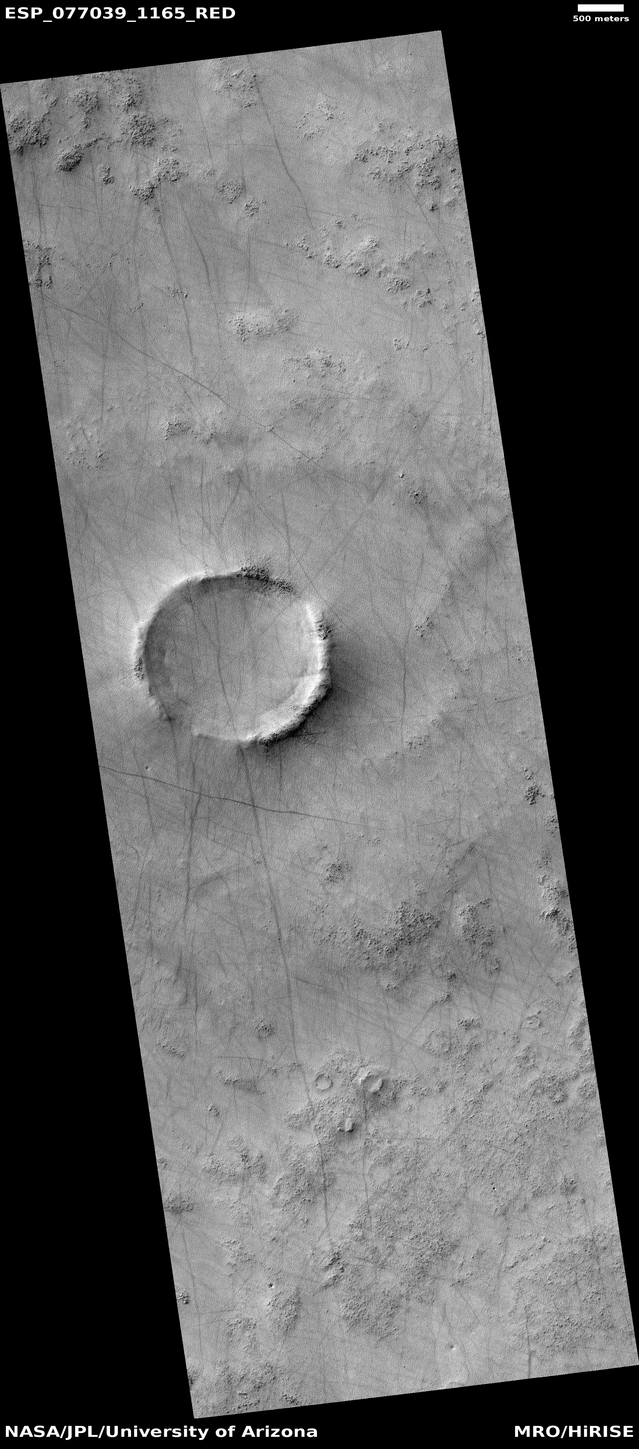
Cool image time! The picture to the right, rotated, cropped, reduced, and sharpened to post here, was taken on January 2, 2023 by the high resolution camera on Mars Reconnaissance Orbiter (MRO). It is once again a terrain sample image, taken not for any specific research but to fill a gap in the schedule so as to maintain the camera’s proper temperature.

What this picture shows is that even though Mars has a thin atmosphere that produces dust devils, the propagation of dust devils is not uniform across the red planet’s surface. In this picture there are a lot of devil tracks, going in many different directions. Yet few of the many cool images I post from MRO show this number of tracks. In many cases the ground might not be agreeable to leaving tracks, but that cannot be the entire explanation.
» Read more

3 comments

Splats on Mars!

Splats on Mars
Click for original image.

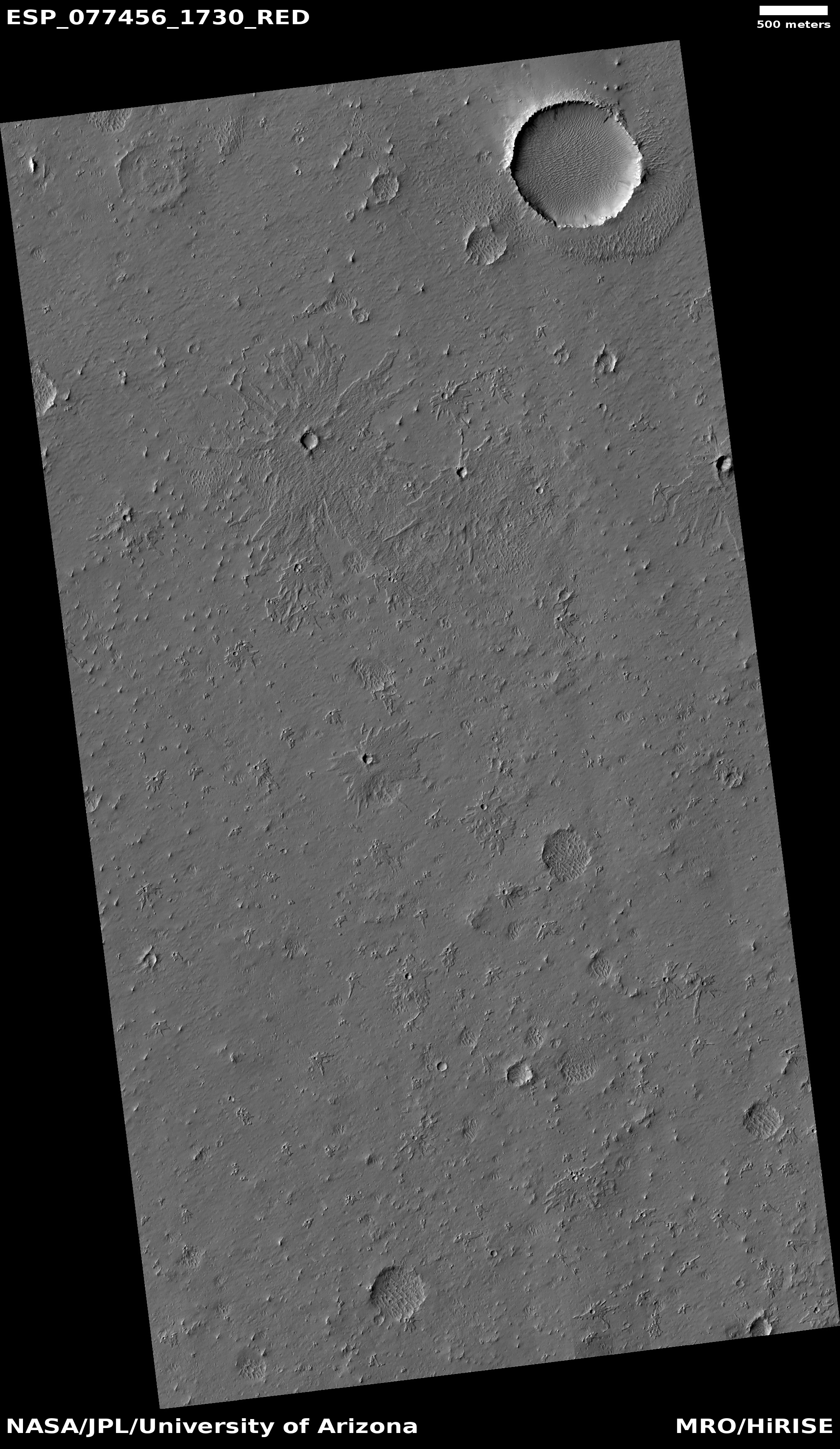
Cool image time! The picture to the right, cropped and sharpened to post here, was taken on February 3, 2023 by the high resolution camera on Mars Reconnaissance Orbiter (MRO). It shows a number of crater splats of varying sizes. If you look at the full image, you will find several even bigger splats to the north of the one in the picture to the right. You will also see many more similar-sized crater splats to the south.

I cannot provide any confident explanation about what caused these splats, other than to assume that most here are secondary impacts from ejecta thrown out by a larger impact somewhere nearby. I also assume all these small impacts occurred at the same time because they all appear to have hit the ground when it had the same thick liquid consistency, a condition that was probably temporary. Note for example how many of the other craters in the full image do not have this same splattered look.
» Read more

1 comment

Hubble looks at a nearby dwarf galaxy

A nearby dwarf galaxy
Click for original image.

Cool image time! The photo to the right, cropped, reduced, and sharpened to post here, was taken by the Hubble Space Telescope as part of a continuing project to capture high resolution images of every nearby galaxy, which in this particular case the caption describes as follows:

UGCA 307 hangs against an irregular backdrop of distant galaxies in this image from the NASA/ESA Hubble Space Telescope. The small galaxy consists of a diffuse band of stars containing red bubbles of gas that mark regions of recent star formation, and lies roughly 26 million light-years from Earth in the constellation Corvus. Appearing as just a small patch of stars, UGCA 307 is a diminutive dwarf galaxy without a defined structure — resembling nothing more than a hazy patch of passing cloud.

The red regions of star formation are significant, as they indicate that even in a tiny galaxy like this it is possible for there to be enough gas and dust to coalesce into new stars.

Astronomers living on a world inside this galaxy have an advantage over astronomers on Earth. There is no large galaxy like the Milky Way blocking their view of the cosmos in one direction. They can see it all, even in directions looking through UGCA 307.

11 comments

Curiosity looks ahead: Which way to go?

Curiosity's view on March 11, 2023
Click for high resolution version. For original images, go here and here.

Overview map

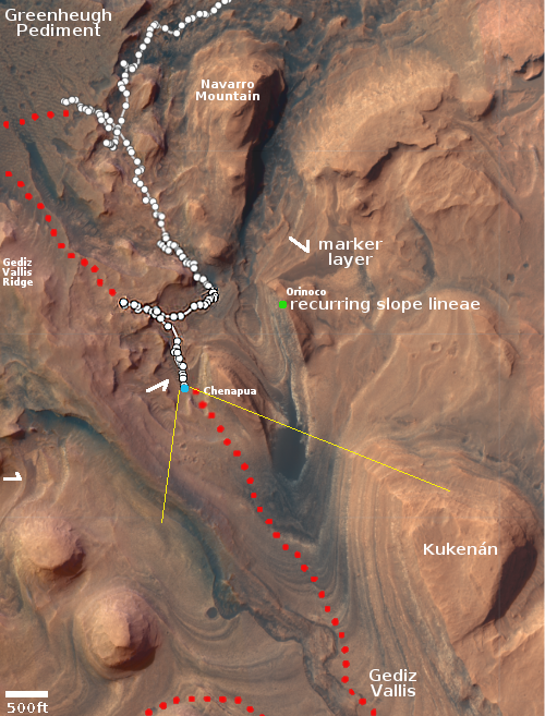
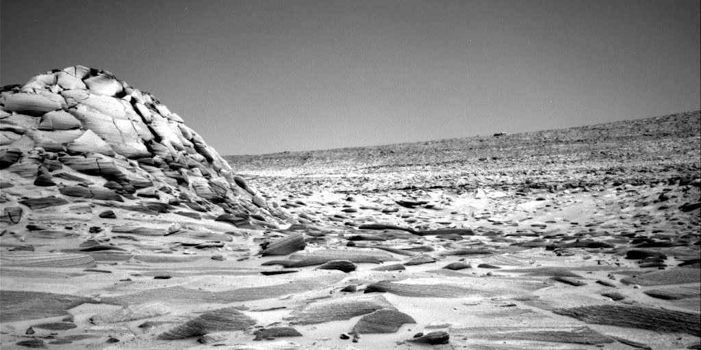
How about a bonus weekend cool image! The panorama above, created from two pictures taken on March 11, 2023 by the right navigation camera on the Mars rover Curiosity, gives us a wonderful view of the alien Martian terrain that the rover is presently within. It also shows us the dilemma mission planners have in planning the rover’s future travels.

The red dotted line on both the panorama and the overview map to the right indicates the planned route. The yellow lines on the map indicates the approximate area viewed by the panorama. The blue dot marks Curiosity’s present position, where it is presently in the middle of a drilling campaign in the marker layer where it sits.

The plan had been to travel to the east of what I like to call the the hill of pillows (in the middle of the panorama). Yet, it appears from this navigation image that the terrain might be less difficult to the west. Both routes will get the rover to its goal in Gediz Vallis.

I have no idea what the mission planners will decide to do. I am just a tourist going along for the ride, and sharing the journey with my readers. This is the first time any human spacecraft has ever traveled through such mountainous terrain on any planet.

5 comments
1 75 76 77 78 79 89