Rocks broken by Curiosity’s wheels contain the first pure sulfur crystals found on Mars

Curiosity's robot arm about to take a close look at the ground
Click for original image.

Close-up of rocks on Mars
Click for original image.

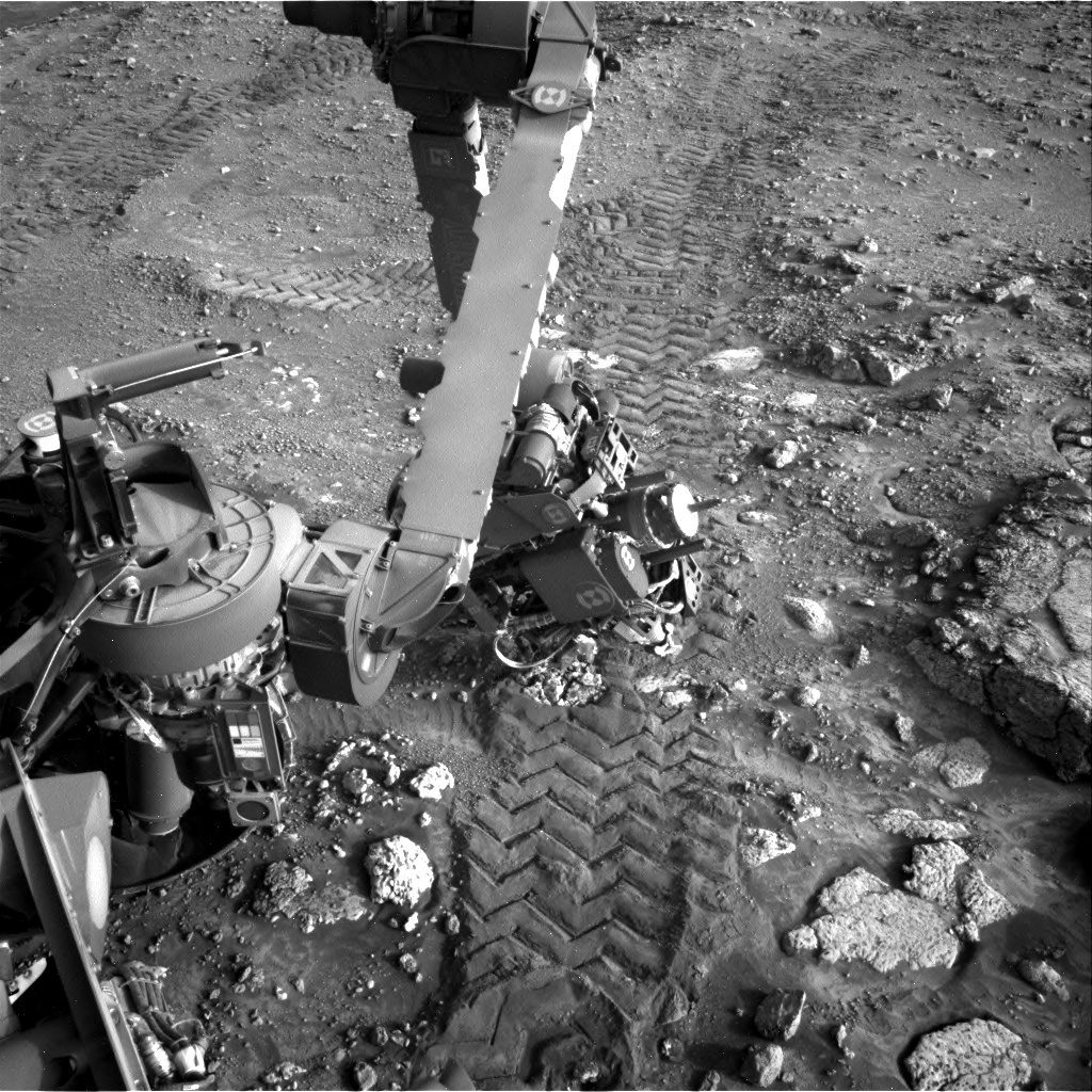
When Curiosity completed a drive on May 30, 2024, subsequent images from the rover revealed that the wheels had broken apart some small rocks, revealing very bright yellow materials not normally seen on the planet.

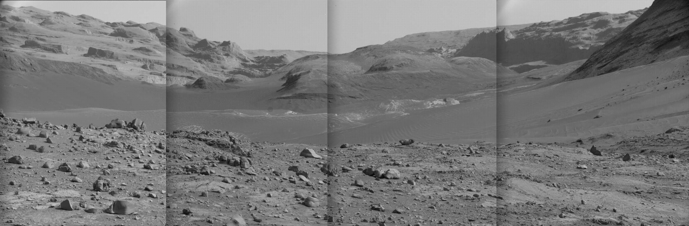
I posted those images on June 7, 2024 — noting that such colorful and crystal-like surface features have been rarely seen by Curiosity — and post them again now, with the top picture showing the broken rocks, labeled as “target rocks”, just after the robot arm had rotated up and away from a close inspection and imaging of those rocks. The picture to the right is a close-up taken by Curiosity’s Mars Hand Lens Imager (MAHLI), located at the end of the rover’s robot arm and designed to get close-up high resolution images of the ground that the arm is exploring. Everything in this image is tiny, in the millimeters in scale.

The science team yesterday confirmed that those unusual rocks are the first pure crystals of sulfur found on the red planet.

Since October 2023, the rover has been exploring a region of Mars rich with sulfates, a kind of salt that contains sulfur and forms as water evaporates. But where past detections have been of sulfur-based minerals — in other words, a mix of sulfur and other materials — the rock Curiosity recently cracked open is made of elemental, or pure, sulfur. It isn’t clear what relationship, if any, the elemental sulfur has to other sulfur-based minerals in the area.

While people associate sulfur with the odor from rotten eggs (the result of hydrogen sulfide gas), elemental sulfur is odorless. It forms in only a narrow range of conditions that scientists haven’t associated with the history of this location. And Curiosity found a lot of it — an entire field of bright rocks that look similar to the one the rover crushed.

Analysis of samples taken from drilling into a nearby much more structurally solid rock is presently on-going. As for theories explaining the presence of this pure sulfur, those are being worked on as well.

1 comment

Curiosity looks up Gediz Vallis as it starts its journey out

Curiosity panorama looking south on July 16, 2024Curiosity panorama looking south on July 16, 2024. Click for high resolution. Go here, here, here, and here
for original images.

Overview map
Click for interactive map.

Even as the Curiosity science team is beginning the rover’s journey out of the giant Martian slot canyon Gediz Vallis, they have on July 16, 2024 used its high resolution camera to gather a new mosaic of the surrounding terrain. I have used four of those images (available here, here, here, and here) to create a panorama, as shown above, focusing on the view looking south up into Gediz Vallis. Make sure you click on the image to see the full resolution version.

The overview map to the right provides the context. The blue dot marks Curiousity’s present position. The yellow lines indicate the approximate area covered by the panorama. The white dotted line indicates Curiosity’s actual traveled route, while the red dotted line the planned route.

The peak of Mount Sharp is directly ahead in this panorama, out of sight and about 26 miles away and 16,000 feet higher up. To get a sense of how far away that remains, note that Curiosity in its dozen years of exploration on Mars has so far traveled just under 20 miles and climbed about 2,500 feet.

The plan is to back track downhill and circle around the nose of the western wall of Gediz Vallis and head south in a parallel canyon that is believed to provide easier traveling for Curiosity’s damaged wheels.

0 comments

Layered Martian mesa inside crater

Layered mesa on Mars
Click for original image.

Cool image time! The picture to the right, cropped, reduced, and enhanced to post here, was taken on May 14, 2024 by the high resolution camera on Mars Reconnaissance Orbiter (MRO). It shows what the scientists label as a “layered butte inside small crater.”

The crater is only about 1.8 miles across, and is only a couple of hundred feet deep, at the most. Because this crater sits on a large slope rising to the southwest, the mesa’s peak is actually about thirty feet higher than the crater’s northern rim, but is still below the southern rim by about 70 feet.

A close look at the mesa’s slopes suggests about a dozen obvious layers, though based on data from the rovers Curiosity and Perseverance, those obvious layers are probably divided into many hundreds of thinner layers in between.

What caused these layers? And how did such a small crater get such a relatively large mesa in its center? As always, the overview map provides some clues, but as always it does not provide a definitive answer.
» Read more

2 comments

Martian taffy terrain

Martian taffy terrain
Click for original image.

Cool image time! The picture to the right, rotated, cropped, reduced, and enhanced to post here, was taken on April 11, 2024 by the high resolution camera on Mars Reconnaissance Orbiter (MRO). It shows a typical area of what scientists have labeled “taffy terrain,” a landscape made up of strangely twisted bands that look like someone was pulling the ground repeatedly, just like taffy.

Based on the lower crater count found here, taffy terrain is thought to be relative young, formed around three billion years ago. While the exact formation process is not yet understood, scientists theorize that it was caused by some type of “viscous fluid” that settled into localized depressions.

The location is 40 degrees south latitude, so it is entirely possible we are seeing some form of glacial material, ice in these low spots that has no place to go but is warped over time by the same kind of tidal and rotational planetary effects that cause waves and tides in the oceans on Earth.
» Read more

0 comments

A ridge that runs right over a Martian mesa

A dike in a mesa
Click for original image.

Cool image time! The picture to the right, cropped, reduced, and sharpened to post here, was taken on April 5, 2024 by the high resolution camera on Mars Reconnaissance Orbiter (MRO). I have cropped it to focus on the geological feature that likely attracted the interest of the scientists who requested this photo, the mesa that has a ridgeline running over it as if the mesa was not even there.

The mesa is about 80 feet high on its west side, but on its east the ground continues to drop away more than 500 feet as you move 2.5 miles to the east. Based on how the MRO science team interprets the colors [pdf] in the color strip, the orange areas are likely dust while the greenish surface suggests coarser sand and boulders. This conclusion is reinforced if you look at the parallel dunes south of the mesa. The dunes are yellow-orange (dust) while the ground between is yellow-green (sand), exactly what you expect with the larger coarser material settling in lower elevations.

The overview map provides the context, which might help explain the ridgeline.
» Read more

0 comments

Reanalysis of Apollo seismic data finds 22,000 previously undetected quakes

By taking a new look at the data from the seismometers placed on the lunar surface by the Apollo missions during the 1970s, Keisuke Onodera of the University of Tokyo was able to find approximately 22,000 previously undetected quakes, almost tripling the rate of seismic activity on the Moon. From the paper’s abstract:

In the 1970s, two types of seismometers were installed on the nearside of the Moon. One type is called the Long-Period (LP) seismometer, which is sensitive below 1.5 Hz. The other is called the Short-Period (SP) seismometer, whose sensitivity is high around 2–10 Hz. So far, more than 13,000 seismic events have been identified through analyzing the LP data, which allowed us to investigate lunar seismicity and its internal structure.

On the other hand, most of the SP data have remained unanalyzed because they include numerous artifacts. This fact leads to the hypotheses that (a) we have missed lots of high-frequency seismic events and (b) lunar seismicity could be underestimated.

To verify these ideas, I conducted an analysis of the SP data. … I discovered 22,000 new seismic events, including thermal moonquakes, impact-induced events, and shallow moonquakes. Among these, I focused on analyzing shallow moonquakes—tectonic-related quakes. Consequently, it turned out that there were 2.6 times more tectonic events than considered before. Furthermore, additional detections of shallow moonquakes enabled me to see the regionality in seismicity. Comparing three landing sites (Apollo 14, 15, and 16), I found that the Apollo 15 site was more seismically active than others. These findings can change the conventional views of lunar seismicity.

The data also suggests the northern hemisphere is more active than the southern.

1 comment

A jumble of blocks in the middle of a Martian flood lava plain

A jumble of blocks on Mars
Click for original image.

Cool image time! The picture to the right, cropped, reduced, and sharpened to post here, was taken on March 18, 2024 by the high resolution camera on Mars Reconnaissance Orbiter (MRO).

This is one of what I like to call “What the heck?” images. The broken up blocks resemble ice floes on the edge of the Arctic ice cap that have broken off and have begun floating away.

The problem with this theory is many fold. First, this is on Mars and not on Earth. Second the “sea” these blocks are supposedly “floating” in is actual solid lava. There is no water or ice here, on the surface or even underground. This is in the dry tropics of Mars, where little or no near-surface ice has so far been detected.

The overview map below provides some context, and possibly an explanation.
» Read more

3 comments

A drainage gully on Mars?

A drainage gully on Mars?
Click for original image.

Overview map

Cool image time! The picture above, cropped, reduced, and sharpened to post here, was taken on April 18, 2024 by the high resolution camera on Mars Reconnaissance Orbiter (MRO). It shows a gully that cuts down from the western rim of a 21-mile-wide unnamed crater in the southern cratered highlands of Mars.

The small rectangle on the overview map to the right marks the location, with the inset providing a close-up of this crater, with the white bar indicating the area covered by the photo above. The overall elevation loss from the rim on the left down to the crater floor on the right is about 3,800 feet.

The first high resolution picture of this gully was taken in 2016, with subsequent pictures taken in 2021 and 2022. In comparing the newest picture above with the 2016 photo I can detect no changes, but I am not looking a the highest resolution available. In addition, both of these pictures were taken during the Martian spring. The 2021 and 2022 pictures were taken during the Martian summer, and in both the north-facing wall where the gully is beginning to narrow seemed brighter.

It is likely the researchers are looking to see if any frost — either ice or dry ice — appeared during the winter and then sublimated away in the summer. Such a change could cause some of the erosion that produced this gully.

0 comments

Geology on Mars is not always what you think it is

The Martian tropics versus the Martian south pole
For the original images go here and here.

Today’s cool image is actually a comparison of two different high resolution images from Mars Reconnaissance Orbiter (MRO), both of which illustrate why it is very dangerous to come to any conclusions about such images without knowing a lot more about them.

The top image to the right, cropped to post here, was a terrain sample image taken on March 30, 2024. Such images are usually taken not to complete any particular research project, but are taken to fill a gap in the schedule in order to maintain the camera’s proper temperature. When the camera team has to do this, they attempt to pick a spot that might have some geological interest. Sometimes they get something surprising. Often however the features in the picture are boring.

In this case they spotted a place where the ground appears appears to be eroding away in a random pattern.

The bottom image, cropped, reduced, and enhanced to post here, was taken on March 24, 2024 and was part of planned research. It shows a section of the Martian south ice cap, specifically the area where scientists believe there is a residual permanent small cap of dry ice on top of a thick underlying water ice cap.

Like the top image, the features here suggest some sort of erosion process eating away randomly at the ground’s upper layers.

The two images illustrate the difficulty of interpreting orbital images. At first glance the geological features of both appear very similar. Yet the top image is located in the very dry equatorial regions of Mars, and in fact is inside the Medusae Fossae Formation, the largest field of volcanic ash on the red planet. The layers here are likely ash, and the erosion that carved out the hollows likely came from wind. If there ever was near-surface ice at this location, it was many eons ago.

The bottom image however likely shows the sublimation process that is slowly eating away at the residual dry ice cap at the south pole. The Martian north pole does not have residual permanent cap of frozen carbon dioxide, and the reasons why the two caps are different in this way are complex and not completely understood.

Both images show erosion that produces features that look similar. But the materials involved and the causes are completely different.

Remember this when you look at any orbital picture taken of Mars, or any other planetary object. Without the larger context (location, make-up, known history), any guess about the nature of the features there is nothing more than a wild guess, no different than throwing darts at a wall while wearing a blindfold.

2 comments

Juno infrared data confirms existence of at least eleven lava lakes on Io

Cartoon describing Io's lava lakes
Click for original image.

Using infrared data from the Jupiter orbiter Juno, obtained during a close fly-by in May 2023 of the moon Io, scientists have identified what appear to be at least eleven active lava lakes, all filled with liquid magma under a surface crust and having a stable perimeter that apparently does not overflow the rim.

You can read the research paper here. The graphic to the right is figure 6 from the paper, describing two models for explaining why the lava in these lakes never rises high enough to pour out.

Unlike the April fly-by, which got as close as 10,777 miles and produced some amazing imagery, the May fly-by only got within 22,000 miles, but its course allowed Juno’s infrared instruments to collect good global data for six hours.

The JIRAM data reveal a common set of thermal characteristics for at least ten patera, with bright “thermal rings” around the perimeter of their floors. Loki, Surt, Fuchi, Amaterasu, Mulungu, Chors, and Dazhbog paterae, two unnamed paterae (here referred to as UP1 and UP2), and two other potential additional paterae (not discussed further because the spatial resolution is poor), all show the same pattern of surface temperatures.

That data suggested that each patera was a hot lava lake, with a stable rim in which little magma ever overflowed. As the scientists conclude in their paper, “Present findings highlight Io’s abundant lava reserves, resembling lava lakes on Earth in some ways, yet distinctly different from any other phenomena observed in the Solar System.” The scientists also note that no missions are being planned right now to get a better look at Io.

0 comments

An island of hundreds of scour pits in Mars’ largest volcanic ash field

An island of scour pits
Click for original image.

Cool image time! The picture to the left, cropped, reduced, and sharpened to post here, was taken on April 25, 2024 by the high resolution camera on Mars Reconnaissance Orbiter (MRO).

It shows what the science team labels a “scour pit island,” an area about 13 miles long and 3.5 miles wide where the ground is covered by these pits.

Your eye may play tricks on you, reversing the elevations. These are all pits, with most having a central peak or ridgeline. To help, note that the sunlight is coming from the west. The arrow on the center left of the picture sits on a plateau above these pits.

According to this paper [pdf], the pits are slowly dug out by the wind coming from the southeast blowing to the northwest, as indicated by the arrows. The central peaks or ridges are thought to be a hint of the original topography, with the wind only able to pull ash from the terrain around these peaks.
» Read more

0 comments

Massive Martian landslides

Massive Martian landslides
For original images go here and here.

Overview map

Today’s two cool images above provide a nice sense of the massive nature of many Martian landslides. Scientists often call this kind of slide “mass wasting,” because rather than it occurring because a single rock propagates a larger flow of rocks as it starts rolling downhill, this slide occurs because a large section of the hillside suddenly breaks free and moves downward as a unit, carving a path as it goes.

Mars has a lot of these kinds of slides, likely caused partly by its lower gravity, 39% that of Earth’s.

The overview map to the right marks the location of both slides by their numbers. Number one took place on the eastern interior rim of a 56-mile-wide and 7,000-foot-deep unnamed crater the dry tropics of Mars. The slide dropped about 3,000 feet, beginning about halfway down from the top of the rim and not quite reaching the crater floor. The picture was taken by the high resolution camera on Mars Reconnaissance Orbiter (MRO) on March 31, 2024.

Number two occurred on the western interior rim of a 32-mile-wide and 6,500-foot-deep unnamed crater in the mid-latitudes where near-surface ice and glacial features are often found. In this case the slide fell downward about 3,500 feet. The picture was taken by MRO’s high resolution camera on March 14, 2024.

Despite the different latitudes and thus different climates and geological settings, both landslides look similar. It is possible they occurred under similar conditions, but at very different times. Or it is also possible that the Mars gravity and general environment promotes these mass wasting events everywhere.

3 comments
1 23 24 25 26 27 157