
New data suggests Europa’s surface is constantly changing
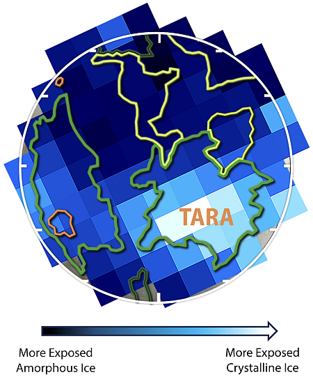
Click for original graphic.
The uncertainty of science: Using data collected by the Webb Space Telescope combined with modeling and lab experiments, scientists now think they have found evidence that Europa’s surface is constantly changing, with materials from its interior being brought to the surface.
This new study found crystalline ice on the surface as well as at depth in some areas on Europa, especially an area known as Tara Regio. “We think that the surface is fairly porous and warm enough in some areas to allow the ice to recrystallize rapidly,” said Dr. Richard Cartwright, lead author of the paper and a spectroscopist at Johns Hopkins University’s Applied Physics Laboratory. “Also, in this same region, generally referred to as a chaos region, we see a lot of other unusual things, including the best evidence for sodium chloride, like table salt, probably originating from its interior ocean. We also see some of the strongest evidence for CO2 and hydrogen peroxide on Europa.”
…“Our data showed strong indications that what we are seeing must be sourced from the interior, perhaps from a subsurface ocean nearly 20 miles (30 kilometers) beneath Europa’s thick icy shell,” said [Dr. Ujjwal Raut of the Southwest Research Institute and co-author of the paper]. “This region of fractured surface materials could point to geologic processes pushing subsurface materials up from below. When we see evidence of CO2 at the surface, we think it must have come from an ocean below the surface.”
The graphic to the right shows the detected variations across the surface of Europa, based on the Webb spectroscopic data. It also illustrates nicely the coarseness of this data, its lack of resolution, and the uncertainties involved. The scientists have found evidence that suggests the surface is changing, but the key word here is “suggests”. They have not yet directly seen any actual changes, such as changes between two images taken at different times.
Nonetheless, the data does point in the right direction. Moreover, it would be far more unlikely if nothing on Europa changed. The fundamental question that remains unanswered is how fast things change there. And we won’t have any chance to answer this question until Europa Clipper enters Jupiter orbit in 2030 and begins multiply fly-bys of Europa.


