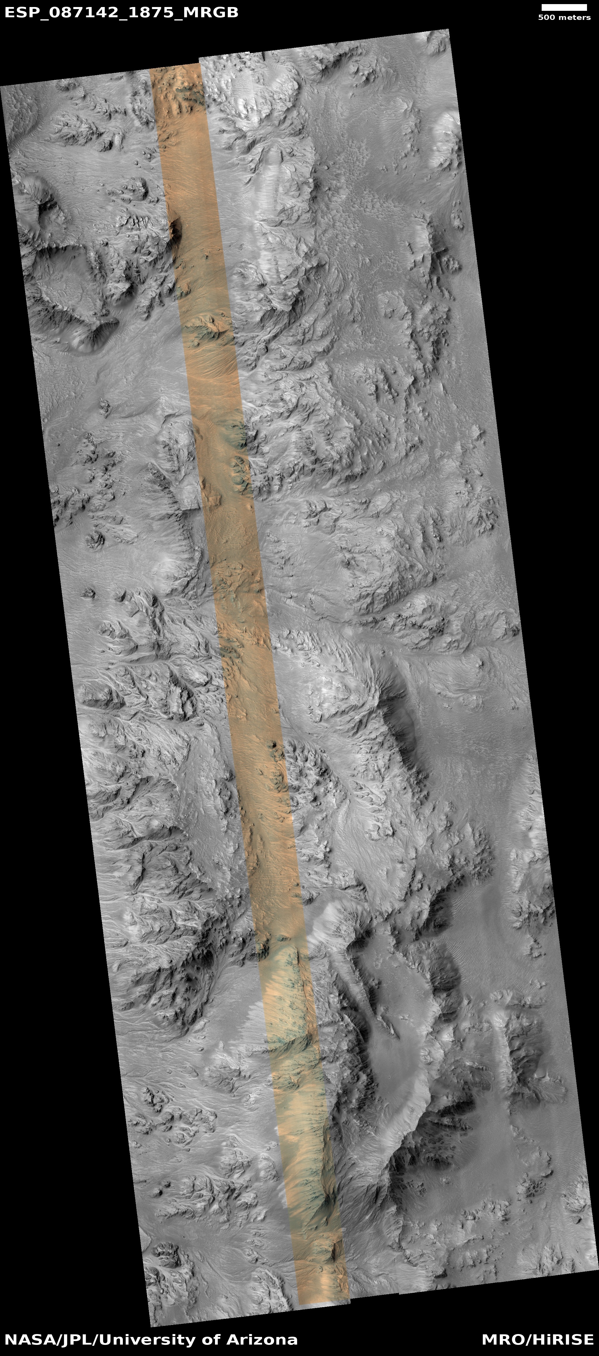
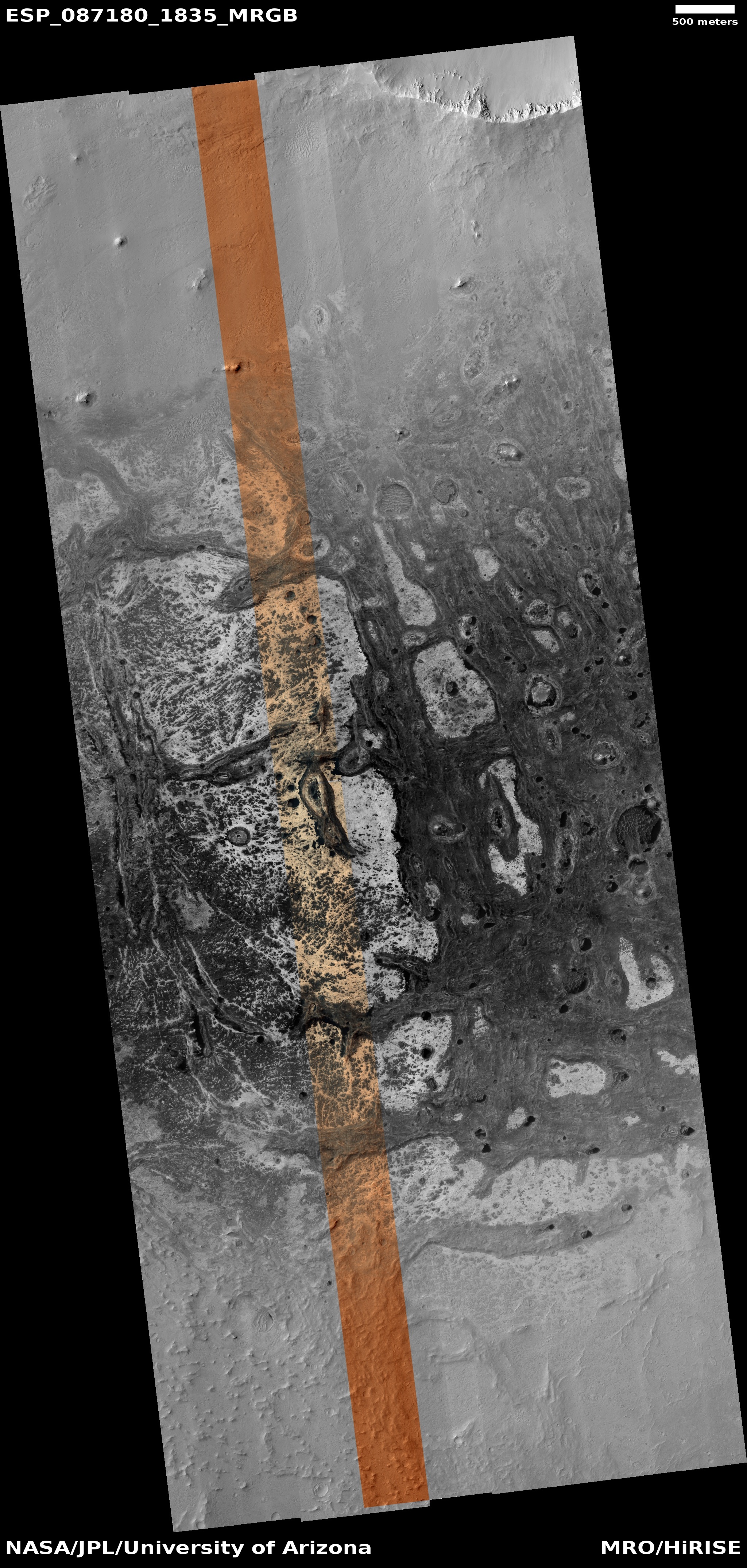
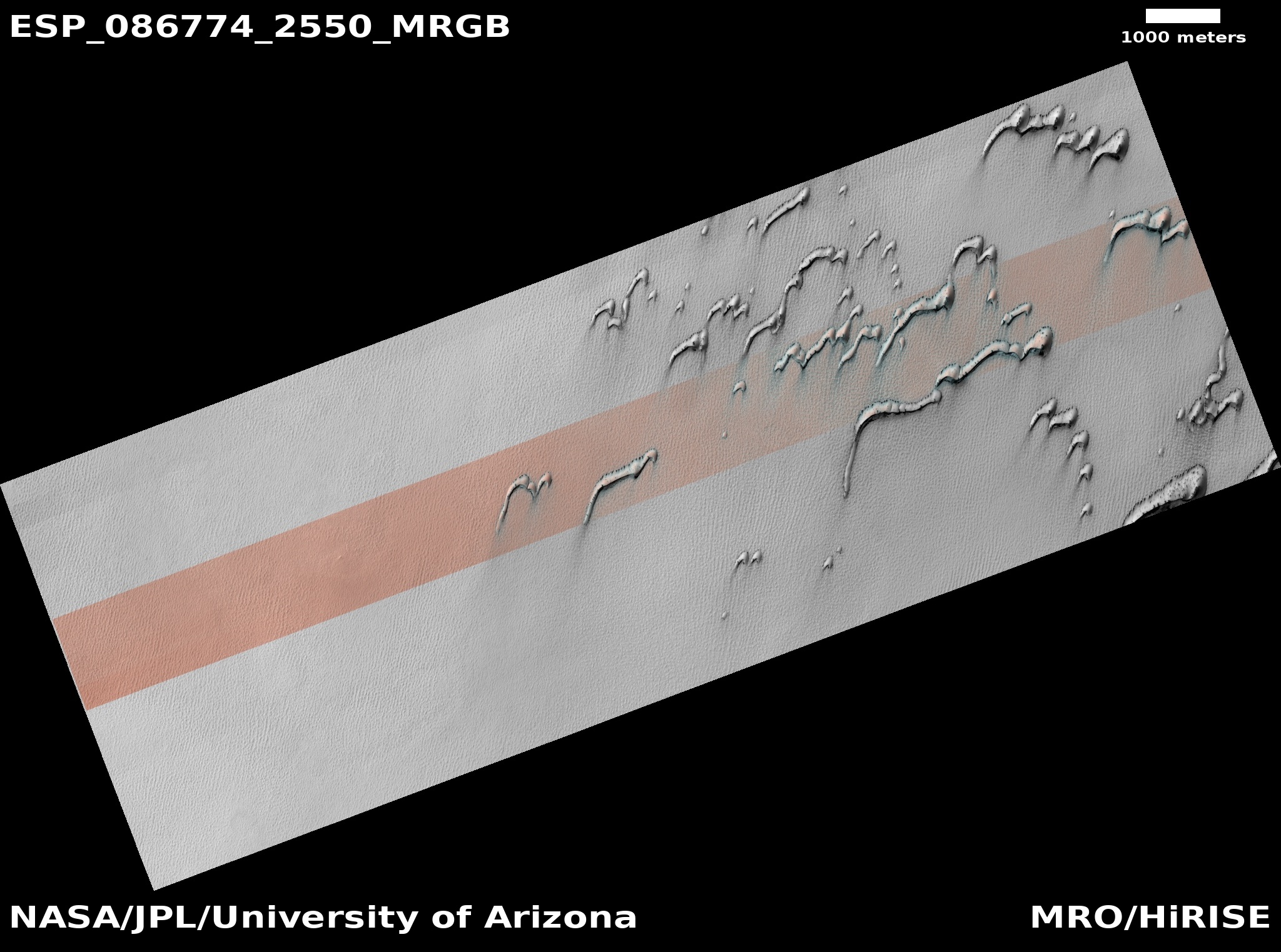
A Martian crater with a wake of lava

Overview map

Cool image time! Today’s cool image begins with the overview map to the right. The white dot marks its location, on the western edge of Amazonis Planitia and about 1,000 miles east of the giant shield volcano Elysium Mons.

This is a region of numerous flood lava events that appear to cover the knobby mountainous terrain that was once here. We know that past terrain was knobby because in the black outline just south of this picture the knobs are everywhere, short peaks sticking up from a very flat flood lava plain. The region is also on the northern edge of the dry equatorial regions of Mars, at 27 degrees north latitude. It is likely there is little near surface ice here.

These details will help explain the cool image itself.
» Read more

The icy mesas of Mars’ glacier country

Overview map

The ice mesas of Mars' glacier country
Click for original image.

Cool image time! The picture to the right, rotated, cropped, and reduced to post here, was taken on March 25, 2023 by the high resolution camera on Mars Reconnaissance Orbiter (MRO). The science team labeled this image “Cross-Section of Glacier-Like Form,” probably because the mesa in the center of the picture clearly shows numerous layers as you descend from its peak to the surrounding plains, an elevation difference of about 200 feet.

The white dot about 250 miles due south of Lyot Crater on the overview map above marks the location of this mesa, inside the chaos terrain of Deuteronilus Mensae that is the western section of the 2,000 long strip in the northern mid-latitudes of Mars that I call glacier country, since practically every image, like today’s, suggests the presence of glaciers.

The oblique mosaic below, created using MRO’s context camera images, illustrates this fact even more spectacularly.
» Read more

Drainage channel between two Martian hollows

Drainage channel between two Martian hollows
Click for original image.

Cool image time! The picture to the right, cropped, reduced, and sharpened to post here, was taken on April 28, 2023 by the high resolution camera on Mars Reconnaissance Orbiter (MRO). Dubbed a “terrain sample” by the camera team, it was likely taken not as part of any specific research project but to fill a gap in the camera’s schedule so as to maintain that camera’s proper temperature. When they have to do this, they try to pick interesting targets, though there is no guarantee the result will be very interesting.

In this case the camera snapped what appears to be a drainage channel between two deeper hollows. The channel sits about 100 feet above the western hollow and 260 feet above the eastern hollow. This makes some sense, as the overall drainage in this region is going from the west to the east, and then to the north.
» Read more

Rimstone dams in Mars’ youngest lava deposit

Rimstone dams in Mars' youngest lava deposit
Click for original image.

Cool image time! The picture to the right, rotated, cropped, reduced, and sharpened to post here, was taken on April 23, 2023 by the high resolution camera on Mars Reconnaissance Orbiter (MRO).

The scientists dub the features here merely as “land forms,” probably because it is difficult to explain the origins of many of these strange features. For example, why is the half-mile-wide crater filled that knobby terrain, far different than the surrounding plains? Similarly, what caused the small meandering ridges (less than five feet high) that appear to closely resemble the cave formation called rimstone dams?

And why is this terrain so generally flat and smooth?

As usual, the overview map helps explains some of this, but not all.
» Read more

Eroding glacier on Martian slope?

Eroding glacier on Martian slope?
Click for original image.

Cool image time! The picture to the right, enhanced, cropped, reduced, and sharpened to post here, was taken on April 1, 2023 by the high resolution camera on Mars Reconnaissance Orbiter (MRO). It shows what the science team labels as “Rough Ground and Bright Exposures” on the flanks of a wide mountain range on Mars, whose highest point is about 4,400 feet higher to the northeast and about 30 miles away.

The arrow indicates the downhill grade. Notice the smooth flat areas that seem to only partially cover much rougher terrain below. To my eye this top layer resembles an Earth glacier that has partly sublimated or melted away, exposing the rougher bedrock below that has been ground and scraped by the glacier previously.

However, this is not on Earth, so assuming it is like an Earth glacier is dangerous.
» Read more

Ice-filled fissure on Mars?

Ice-filled fissure on Mars?
Click for original image.

Cool image time! The picture to the right, cropped, reduced, and sharpened to post here, was taken on February 15, 2023 by the high resolution camera on Mars Reconnaissance Orbiter (MRO). The science team labeled this a “Terrain Sample”, which suggests but doesn’t guarantee that it was to fill a gap in the camera’s schedule in order to maintain that camera’s proper temperature, and therefore was targeted at a relatively random but potentially interesting location.

What we see is a fissure canyon, about 250 to 300 feet deep with cliffs about 125 high, that appears surrounded and even filled with icelike features. Even the craters on the plateau above the canyon appear like they either impacted in ice, or have since been filled and eroded by that ice.

But is it ice?
» Read more

Distorted floor of a Martian crater

Overview map

Distorted floor of a Martian crater
Click for original image.

Cool image time! The picture to the right, rotated, cropped, reduced, and sharpened to post here, was taken on February 18, 2023 by the high resolution camera on Mars Reconnaissance Orbiter (MRO). It shows what the science team labels “Mantle Layers in Southern Mid-Latitudes.”

I would be less vague. These strangely shaped features invoke the typical glacial features seen throughout the mid-latitudes of Mars. The knobs and outcrops suggest some underlying breakdown that the top layers of glacial material has covered. They also suggest some form of sublimation or erosion process to the glacier itself.

The white rectangle inside the inset on the overview map above marks this location, covering the floor of an unnamed 10-mile-wide crater in the cratered southern highlands at 41 degrees south. In this region all the craters show some evidence of this sublimation, all suggesting that there is a near-surface underlying ice layer that when exposed vanishes to leave depressions or hollows. Here however it appears that ice layer is mostly intact, the knobs and ridges indicating the shape of the bedrock and large breakdown below.

Martian dust devil where none had been before

Dust devil on Mars
Click for original image.

Today’s cool Mars image is especially cool because it is of the exact same place on Mars I had featured in a picture only a little more than one month ago. I return to this spot only a month later because the location was yesterday’s featured captioned image from the high resolution camera team of Mars Reconnaissance Orbiter (MRO). The difference is that this time the camera captured a dust devil there that wasn’t there previously. From the caption:

The dust devil is casting a shadow, which can be used to estimate its height. This image is part of ongoing monitoring activities by HiRISE of seasonal activities on Mars.

Over the years, HiRISE has observed many dust devils. Just like on Earth, dust devils develop when the Sun heats up the ground such that it warms the air directly above it. When air heats up its density decreases causing it to rise up while colder air sinks down driving local convection.

If the region is windy, the wind my end up rotating the “convection cells” caused by the vertical motion of air leading to development of a dust devil. Since the main requirements for development of such features are the presence of dust and a warm ground, we focus our monitoring of dust devils in regions on Mars that are known to be dusty (like Syria Planum), and during the late spring and summer time, when we expect the ground to be warm.

» Read more

Barren land on Mars

Barren land on Mars
Click for original image.

It might seem strange to call any particular place on Mars “barren” when the entire planet has no visible signs of life anywhere. However, much of the surface of Mars involves wind and ice features that show evidence of change and evolution over time. The presence of apparent near-surface ice and glacial features in almost every image located above 30 degrees latitude emphasizes this sense of potential life, even if that life will only be transported from Earth and established there someday by humans.

Today’s cool image to the right, cropped and reduced to post here, has none of these features. It is dry barren bedrock, with only a faint scattering of Martian dust indicated by many faint dust devil tracks.

The picture was taken on March 13, 2023 by the high resolution camera on Mars Reconnaissance Orbiter (MRO). The largest and most distinct flat-topped mesa in the image is only about 100 feet high, with the north-south ridgeline to the south about 20 feet high.
» Read more

Avalanche to the east of Gale Crater on Mars

Landslide on Mars
Click for original picture.

Cool image time! The picture to the right, cropped, reduced, and sharpened to post here, was taken on February 19, 2023 by the high resolution camera on Mars Reconnaissance Orbiter (MRO). It shows an avalanche that slumped downward out of the material that forms the interior western wall of an unnamed 25-mile-wide crater about 100 miles east of Gale Crater, where Curiosity has been roving for more than a decade.

The scientists call these types of Martian avalanches “mass-wasting events”, since the entire mass of the cliff moves downhill in a chunk, rather than as a pile of rocks that grows in size and strength as it picks up material on its way down.

It is not clear how old this slide is. A lot of the material on this slope appears to be Martian dust, some of which has flowed into the avalanche material after it had slide downhill.
» Read more

Shadowcam on South Korea’s Danuri lunar orbiter sees no obvious ice in the permanently shadowed interior of Spudis crater

Overview map

Using Shadowcam, a camera built by Arizona State University that is on South Korea’s Danuri lunar orbiter and is designed to see into very dark regions of little light, scientists have obtained optical images showing the permanently shadowed interior of Spudis Crater, located only about ten miles from the Moon’s south pole.

That picture is below. To the left is an annotated overview created from Lunar Reconnaissance Orbiter (LRO) high resolution images. The white box inside Spudis Crater indicates the area covered by the section of the Shadowcam image I have focused on. The red outlines indicate areas that are thought to be permanently shadowed. The relatively flat ridgeline between Shackleton and Spudis is one of the prime future landing sites for NASA’s Artemis program.
» Read more

Martian rootless cones

Rootless cones
Click for original image.

Cool image time! The picture to the right, cropped, reduced, and sharpened to post here, was taken on March 8, 2023 by the high resolution camera on Mars Reconnaissance Orbiter (MRO).

The camera team labeled this picture simply “Rootless Cones,” which is a feature that is created when the lava that covers the surface is thin, allowing the heated material below (which is not lava) to burst upward, producing the cone and caldera. If you look at the full image you will see other similar clusters of cones scattered about on this very flat and featureless plain. Apparently, the material that this lava plain covered had several similar bursts in a number of areas.

Such cones in this particular lava field are not rare, and in fact are evidence that this particular field is young.
» Read more

Curiosity looks back again as it climbs higher onto Mount Sharp

Panorama
Click for full panorama.

Overview map
Click for interactive map.

After completing several weeks of drilling, Curiosity has once again started climbing the rocky rough slope of Mount Sharp in Gale Crater, working its way up into the giant slot canyon dubbed Gediz Vallis.

The panorama above, cropped, reduced, sharpened, and annotated to post here, was created from 31 pictures taken on May 30, 2023 by the rover’s right navigation camera. It looks back both at Curiosity’s past travels climbing Mount Sharp as well as the now increasingly distant floor and rim of Gale Crater. The rim is about 20-30 miles away.

On the overview map to the right, the blue dot marks Curiosity’s position when this panorama was taken, with the yellow lines indicating the approximate area covered. The white dotted line on both the panorama and map indicates the rover’s actual route, with the red dotted line its planned route.

Because of the steep rough terrain, the science team has shifted the rover a bit to the west as it climbs. It is going to be fascinating to watch how it manages this climb into Gediz Vallis, as it appears the terrain is going to get no less steep or rough.

A typical glacier, on Mars

Overview map

A typical glacier, on Mars
Click for original image.

The cool image from Mars to the right, rotated, cropped, reduced, and sharpened to post here, provides us a good illustration of the lineated grooves that are typically seen on the surface of valley-confined glaciers, both on Earth and on Mars, and are also seen on the patched, grooved surface of Ganymede.

The picture was taken on March 13, 2023 by the high resolution camera on Mars Reconnaissance Orbiter (MRO), and shows what appears to be a glacier flowing through a constriction. The arrow indicates the direction of the downhill grade.

The location, indicated by the white dot inside the inset on the overview map above, marks the location, in the western end of the 2,000 long northern mid-latitude strip on Mars I dub glacier country. In these three mensae regions (Deuteronilus, Protonilus, and Nilosyrtis) of chaos terrain practically every high resolution image shows features that resemble glaciers.

In this case, the glacial flow appears to be draining from a 10-mile-wide ponded circular valley though a narrow gap.

The grooved surface of Ganymede

The grooves of Ganymede
Click for original image.

Cool image time! The picture to the right, reduced to post here, was taken on June 7, 2021 when the Jupiter orbiter Juno did a close flyby of the moon Ganymede, taking four pictures.

Citizen scientists Gerald Eichstädt and Thomas Thomopoulos have now reprocessed parts of those images to bring out the details more clearly (the other new versions available here, and here).

I have chosen to highlight the picture to the right however because it so clearly shows the puzzling grooves that cover much of Ganymede’s surface. While these parallel grooves in many ways mimic the grooves often seen on top of valley glaciers on Earth and Mars, on Ganymede they do not follow any valley floor. Instead, they form patches of parallel grooves that travel in completely different directions, depending on the patch. At the moment their origin is not understood.

These grooves are one of the mysteries that Europe’s Juice probe will attempt to solve when it arrives in orbit around Jupiter in 2031.

Cracking pedestal crater near Mars’ north pole

Cracking pedestal crater near Mars' north pole
Click for original image.

Cool image time! The picture to the right, cropped, reduced, and sharpened to post here, was taken on March 18, 2023 by the high resolution camera on Mars Reconnaissance Orbiter (MRO). I have also rotated it so that north is to the top.

Labeled a “terrain sample” by the camera team, this picture was likely taken not as part of any specific research project, but to fill a gap in the camera’s schedule so as to maintain its proper temperature. As usual, when the camera team needs to do this, they try to pick a target of interest. Sometimes they succeed, sometimes not.

In this case, the picture is of a location only about 800 miles from the Martian north pole, on the northern lowland plains. While the section shown to the right focuses on the largest crater, the full picture includes a few others, all of which appear to have their interior floors cracking in the same way, and all appear to be pedestal craters, sitting above the surrounding terrain, though by not as much.
» Read more

A fractured spot in Mars’ northern lowland plains

A fractured spot in Mars' northern lowland plains
Click for original image.

Cool image time! The picture to the right, cropped, reduced, and sharpened to post here, was taken on February 16, 2023 by the high resolution camera on Mars Reconnaissance Orbiter (MRO). It shows a pockmarked flat plain with a scattering of meandering hollows, each filled with ripple sand dunes that make these depressions resemble at first glance the tracks of tires.

Obviously, we are not looking at evidence of a past giant vehicle moving across the ground on Mars. The MRO science team labels these “fractures,” suggesting some past geological process caused the surface to crack in this manner, with those cracks widening with time due to erosion or sublimation.

The location of course tells us something about that process.
» Read more

The eroding north wall of glacial-filled Harmakhis Valles

The north wall of Harmakhis Valles
Click for original image.

Cool image time! The picture to the right, cropped and reduced to post here, was taken on February 8, 2023 by the high resolution camera on Mars Reconnaissance Orbiter (MRO).

We are looking at the 2,400-foot-high cliff, its lower walls clearly cracking horizontally as they sag downward, with other large sections higher up appearing to have been eroded away in larger pieces.

Yet, the ground below this cliff wall appears to have no debris piles, the kind you would expect below a landslide. Instead, that ground appears to be very glacial in nature, with many linear parallel lines suggesting layers.

The overview map below provides us the context, and an explanation as to where that debris has gone.
» Read more

Knobs on the floor of a Martian caldera

Knobs on the floor of a Martian caldera
Click for original image.

Cool image time! The picture to the right, rotated, cropped, reduced, and sharpened to post here, was taken on February 14, 2023 by the high resolution camera on Mars Reconnaissance Orbiter (MRO) and shows what the scientists have dubbed as “enigmatic knobs” located on the caldera floor of a Martian shield volcano.

The knobs themselves, while puzzling, aren’t that interesting on their own. They are no more than 100 to 200 feet high, and are relatively featureless. Since most lack a pit at their peaks, they are probably not some form of small volcanic vent, though this conclusion is uncertain. The location, at about 30 degrees south latitude, suggests the faint possibility of near surface ice, which could make these mud volcanoes, or a very specific Arctic-type permafrost mound dubbed pingos, but once again the lack of any central pit at their peaks makes these origins also doubtful.

What the knobs however revealed to me was a giant Martian shield volcano I had never noticed before, even though it was hiding in plain sight.
» Read more

Frozen waves of Martian lava?

Frozen waves of Martian lava?
Click for original image.

Cool image time! The picture to the right, rotated, cropped, reduced, and sharpened to post here, was taken on March 17, 2023 by the high resolution camera on Mars Reconnaissance Orbiter (MRO). The science team labeled this a terrain sample image, which implies it was taken not as part of any specific request, but to fill a gap in the camera’s schedule in order to maintain its proper temperature.

What are we looking at? This stippled terrain with curved ridges actually extends quite a distance beyond this image. A MRO context camera picture taken on July 22, 2020 shows its full extent, about 10 miles wide but extending to the north and south about 30 miles total, butting up against a north-south mountain chain to its east that is about seventy miles long with its highest peak about 8,000 feet above this plain.
» Read more

Ancient volcano vent in the Martian southern cratered highlands?

Ancient volcano vent on Mars?
Click for original image.

The nature of today’s cool image suggests both ancient and more recent geological activity, each coming from entirely different sources but both helping to shape the alien Martian surface.

The picture to the right, rotated, cropped, reduced, and sharpened to post here, was taken on March 13, 2023 by the high resolution camera on Mars Reconnaissance Orbiter (MRO). It shows what the science team has labeled an “elongated depression,” sitting in the middle of a relatively flat but very rough stippled circular plain about 60 miles in diameter. An MRO context camera picture, taken on February 19, 2012, covered the central strip of this plain, and shows that its surface is equally rough and stippled everywhere, with only a few craters and one or two slight changes in elevation.

So, how does this feature tell us both about the ancient and recent geological history of this spot on Mars?
» Read more

Buried dying glacier in the Martian dry equatorial regions?

Buried glacial ice in dry equatorial regions?
Click for original image.

Today’s cool image from Mars is not so much unique visually as it is unique in terms of its location. The picture to the right, rotated, cropped, reduced, and sharpened to post here, was taken on January 31, 2023 by the high resolution camera on Mars Reconnaissance Orbiter (MRO). It shows the northern rim of a small crater, with its floor filled with an intriguing mound of material.

The picture was labeled a “terrain sample”, which suggests it wasn’t taken as part of any specific research project by instead to fill a gap in the camera’s schedule. To maintain the camera’s proper temperature, it is necessary to take pictures regularly, and when the camera team finds a gap that is too long, they fill it by choosing some almost random target in that gap that might be interesting. Sometimes it is, sometimes not.

In this case I strongly suspect this target was hardly random. The picture title also mentions MRO’s now retired radar CRISM instrument, which was used to detect evidence of underground ice. My guess is that the camera team thus likely decided to image this crater in high resolution because that radar data suggested the presence of underground ice.

This guess is strongly confirmed by a context camera picture taken of this crater on September 1, 2008. The crater appears surrounded by the typical splash apron one routinely sees around impact craters in the mid- and high-latitude northern lowland plains, where there is a lot of near surface ice.

The bumpy mound seen in high resolution on the floor of this crater could very well be buried glacial ice, as it mimics similar features in the many craters in the mid-latitudes of Mars. But is it buried ice? The location says otherwise.
» Read more

Chaos in the southern cratered highlands of Mars

Chaos in the southern cratered highlands of Mars
Click for full image.vi

Today’s cool image takes us to a part of the cratered southern highlands of Mars that I have not featured much previously. The picture to the right, rotated, cropped, and reduced to post here, was taken on March 7, 2023 by the high resolution camera on Mars Reconnaissance Orbiter (MRO). It shows what appears to be a collection of rough hills and mesas surrounded by a sea of smooth ground that at the base of the cliffs seems to end abruptly.

The smooth ground is probably mantled by a layer of dust and debris. Since this location is at 36 degrees south latitude, there is also probably near surface ice under that layer. The abrupt edges likely indicate where the increasing slope next to the mesas and mounds caused that ice to be exposed and thus sublimate away.

As for the location, we must go to the overview map.
» Read more

Alien textured Martian lava

Alien textured Martian lava
Click for original image.

Cool image time! The picture to the right, cropped to post here, was taken on February 17, 2023 by the high resolution camera on Mars Reconnaissance Orbiter (MRO), and shows what the science team labels “regularly textured ground on Pavonis Mons.”

The arrow in the picture indicates the downhill trend. If you look at the full image, you will see that this texture pattern extends in all directions for a considerable distance, both uphill and down, and even covers the entire floor of a depression that appears to contour along the grade instead of going downhill.

The latitude here is very close to the equator. So, even though the elevation is high, being on the slopes of a giant volcano, there is probably no near surface ice here.
» Read more

Brain terrain in and around pedestal crater on Mars

Brain terrain in and around a pedestal crater on Mars
Click for original image.

Cool image time! The picture to the right, cropped, reduced, and sharpened to post here, was taken on March 10, 2023 by the high resolution camera on Mars Reconnaissance Orbiter (MRO).

As I noted in a cool image only two weeks ago, brain terrain is a geological feature wholly unique to Mars that planetary geologists still do not understand or can explain. They know its knobby interweaving nodules (resembling the convolutions of the human brain) are related to near surface ice and its sublimation into gas, but no one has much confidence in any of the theories that posit the process that forms it.

In this case the brain terrain not only fills the crater, it appears to surround it as well, but only appearing at spots where a smooth top layer has begun to break apart. Moreover, the crater appears to be a pedestal crater, whereby much of the less dense surrounding terrain has vanished, leaving the compacted crater sitting higher.
» Read more

Glacial sinkhole in the Martian southern cratered highlands?

Overview map

Glacial sinkhole in the Martian southern cratered highlands?
Click for original image.

Cool image time! The picture to the right, cropped to post here, was taken on February 21, 2023 by the high resolution camera on Mars Reconnaissance Orbiter (MRO). This is a terrain sample image, which means it was snapped not as part of any specific research project but to fill a gap in the schedule in order to maintain the camera’s proper temperature. As usual, the camera team tried to pick something of interest, and I think they succeeded.

The two large depressions in the center of the picture do not resemble impact craters. They have no rim of ejected material and their shape is very distorted. Instead, both appear to be places where a top layer of ice/debris has sublimated away into gas, exposing a lower layer of glacial material that itself is sublimating away to form the bumpy mounds that fill the floor of the depressions.

The white dot inside the inset box on the overview map above marks this location, just south of the northern wall of a large 30-mile-wide canyon, with its northern floor even more depressed, as if the material in that raised middle a flat pile of glacial debris flowing to the southwest after leaving the gap in the crater to the northeast. An MRO context camera picture taken on January 6, 2016 gives a wider view, showing that there are a lot of these type depressions on the surface of this wide middle upraised floor, as well as some obvious impact craters.

This location is in the mid-latitude band where many glacial features are found. In this part of the southern cratered highlands there is also a lot of evidence of top layers sublimating away, as if the glacial material is a large buried ice sheet that is beginning to disappear at places where it has been exposed by impacts or shifting motion. The depression in the picture above appears to be an example.

Engineers free stuck radar antenna on Juice probe to Jupiter’s big moons

Engineers have successfully freed the 52-foot wide radar antenna on the Juice probe to Jupiter, shaking it enough to release a pin that was blocking deployment.

The pin was freed by employing “back-to-back jolts”. Imagine when you roll your car back and forth to get it freed from mud or snow. It appears this is what they did with the pin.

Juice will arrive in Jupiter orbit in 2031, where it will make numerous fly-bys of Europa, Calisto, and Ganymede, and then settle into an orbit around Ganymede alone. The radar antenna was essential for probing the ice content of these worlds, below the surface.

Hat tip to reader Mike Nelson.

Endless dunes amidst Mars’ giant volcanoes

Endless dunes amidst Mars' giant volcanoes
Click for originial image.

Past cool images on Behind the Black showing endless dune fields on Mars have generally focused on two places, the giant Medusae Fossae Formation volcanic ash deposits in the dry equatorial regions of Mars and the Olympia Undae dune sea that surrounds the Martian north pole.

Today’s image to the right, rotated, cropped, reduced, and sharpened to post here, takes us to a completely different dune sea. Taken on February 14, 2023 by the high resolution camera on Mars Reconnaissance Orbiter (MRO), the picture also shows an endless dune sea, though there is faint evidence on those dune fields of buried features, such as the meandering east-west feature in the picture’s center.

This dune sea is also in the dry equatorial regions, like Medusae, but it is much farther east, and sits surrounded by Mars’ biggest volcanoes.
» Read more

Perseverance data suggests a strong river rushed down the delta in Jezero Crater

Skrinkle Haven on Mars
Click for original image.

Based on the images and geology so far gathered by the Mars rover Perseverance as it has climbed up onto the delta that flowed into Jezero Crater sometime in the far past, scientists now think a roaring river once flowed down that delta.

Years ago, scientists noticed a series of curving bands of layered rock within Jezero Crater that they dubbed “the curvilinear unit.” They could see these layers from space but are finally able to see them up close, thanks to Perseverance.

One location within the curvilinear unit, nicknamed “Skrinkle Haven,” is captured in one of the new Mastcam-Z mosaics [a section of which is posted to the right]. Scientists are sure the curved layers here were formed by powerfully flowing water, but Mastcam-Z’s detailed shots have left them debating what kind: a river such as the Mississippi, which winds snakelike across the landscape, or a braided river like Nebraska’s Platte, which forms small islands of sediment called sandbars.

When viewed from the ground, the curved layers appear arranged in rows that ripple out across the landscape. They could be the remnants of a river’s banks that shifted over time – or the remnants of sandbars that formed in the river. The layers were likely much taller in the past. Scientists suspect that after these piles of sediment turned to rock, they were sandblasted by wind over the eons and carved down to their present size.

The press release say nothing about glacial activity here, but I am willing to bet the scientists have considered this. As it requires a greater leap into the unknown, involving geological processes not yet understood on an alien planet, it is makes sense that they have put it aside at this point. I also am willing to bet that it will pop up again, with time and additional data.

Is this ice or lava in the death valley of Mars?

Ice or lava on Mars?
Click for original image.

Cool image time! The picture to the right, rotated, cropped, reduced, and sharpened to post here, was taken on February 28, 2023 by the high resolution camera on Mars Reconnaissance Orbiter (MRO).

To put it mildly this is strange terrain. The curving east-west feature resembles a glacial flow, but it also has features that say otherwise. For example, what could cause that gap in the middle of the picture? Such things are not usually seen in an ice flow. Then there is that filled crater on the center left edge of the picture, inside the flow. Though filled with material, the flow itself does not flow around the crater, suggesting the impact occurred after the flow. Moreover the crater is a pedestal crater, whereby the surrounding terrain has eroded away so that the crater ends up standing above it.

These facts suggest that this flow is very old, and has not flowed for a very very very long time. This in turn suggests it isn’t ice but solidified lava, though for a lava flow it also has features that are anomalous when compared to typical flood lava on Mars.
» Read more

1 7 8 9 10 11 52