Knobs on the floor of a Martian caldera

Knobs on the floor of a Martian caldera
Click for original image.

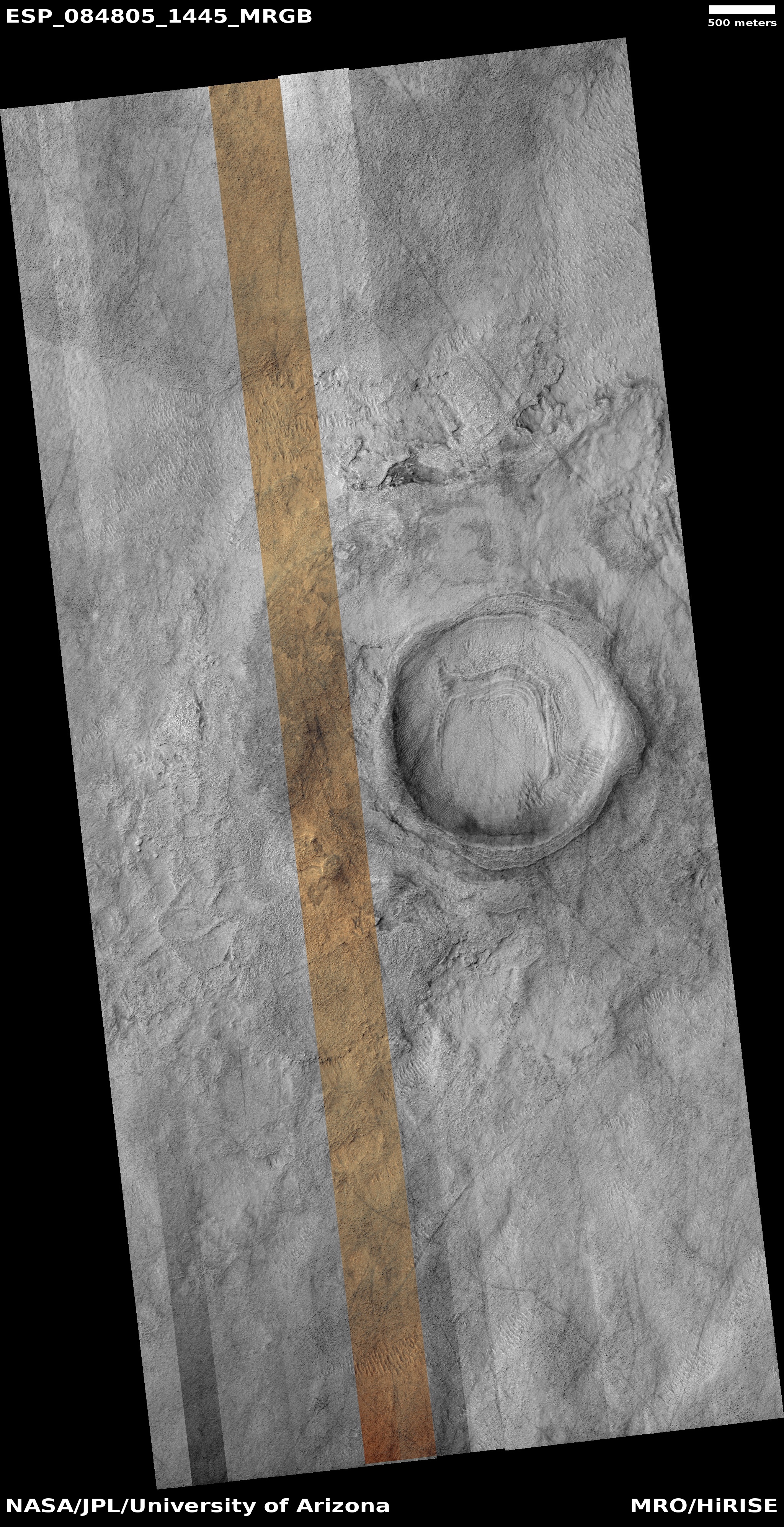
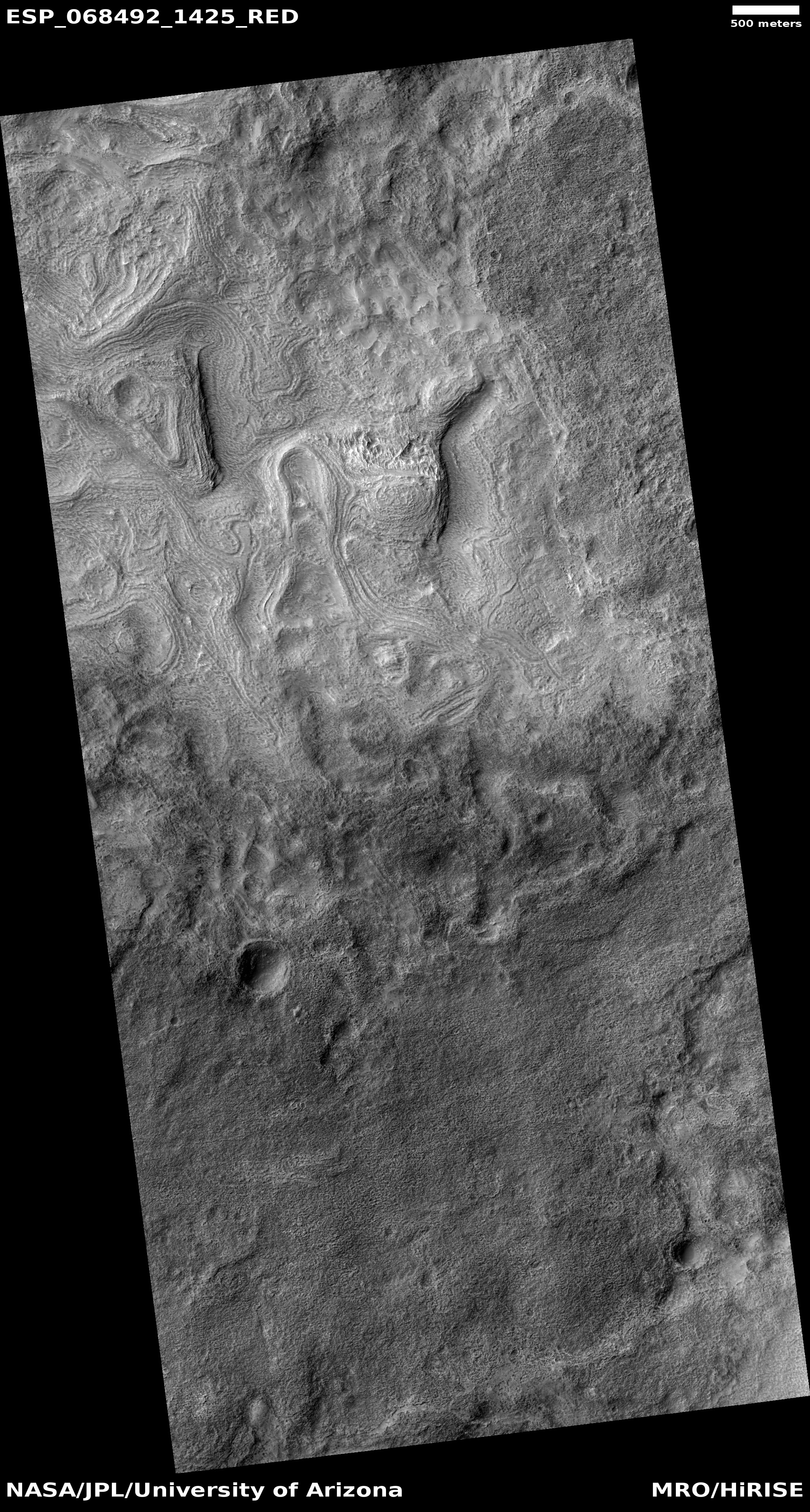
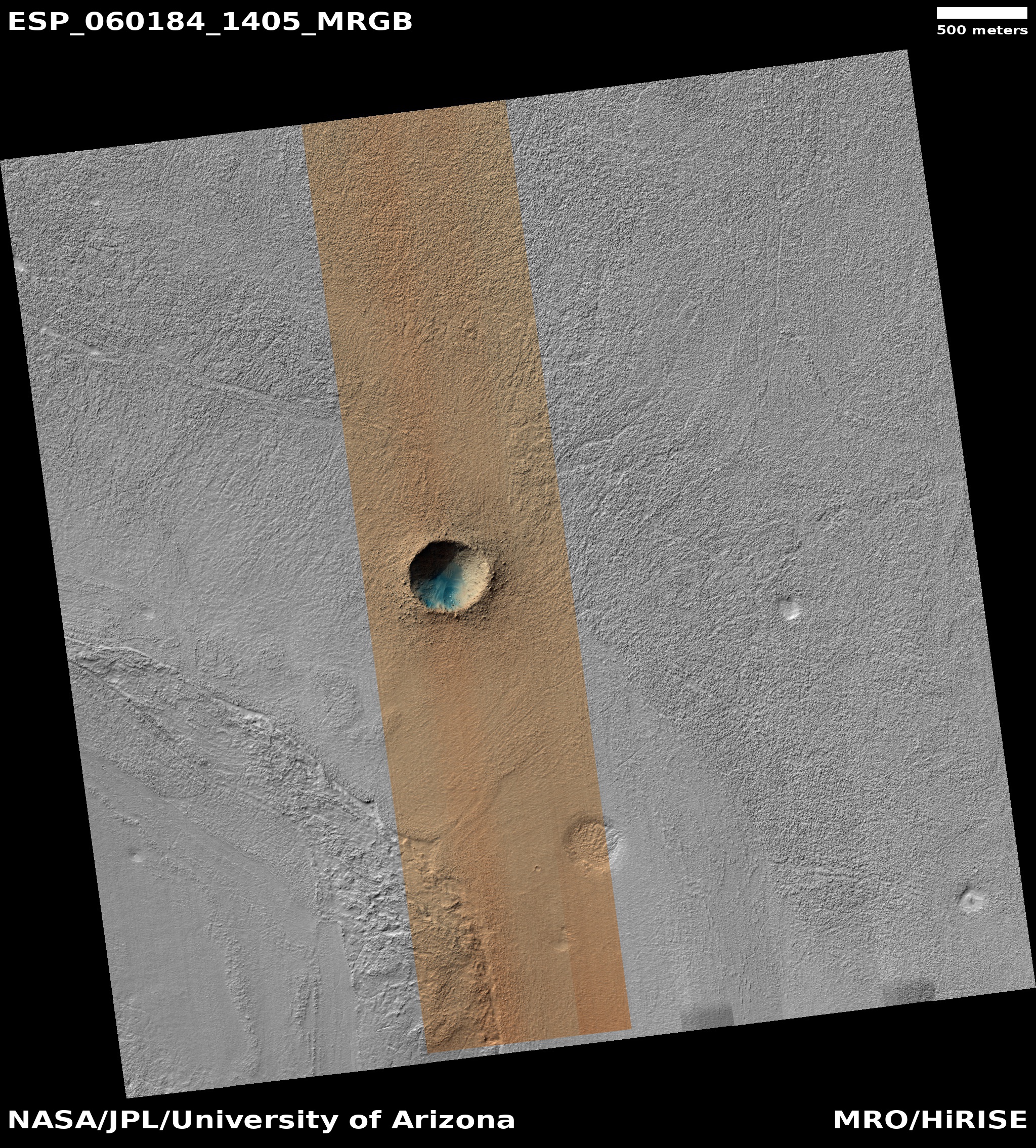
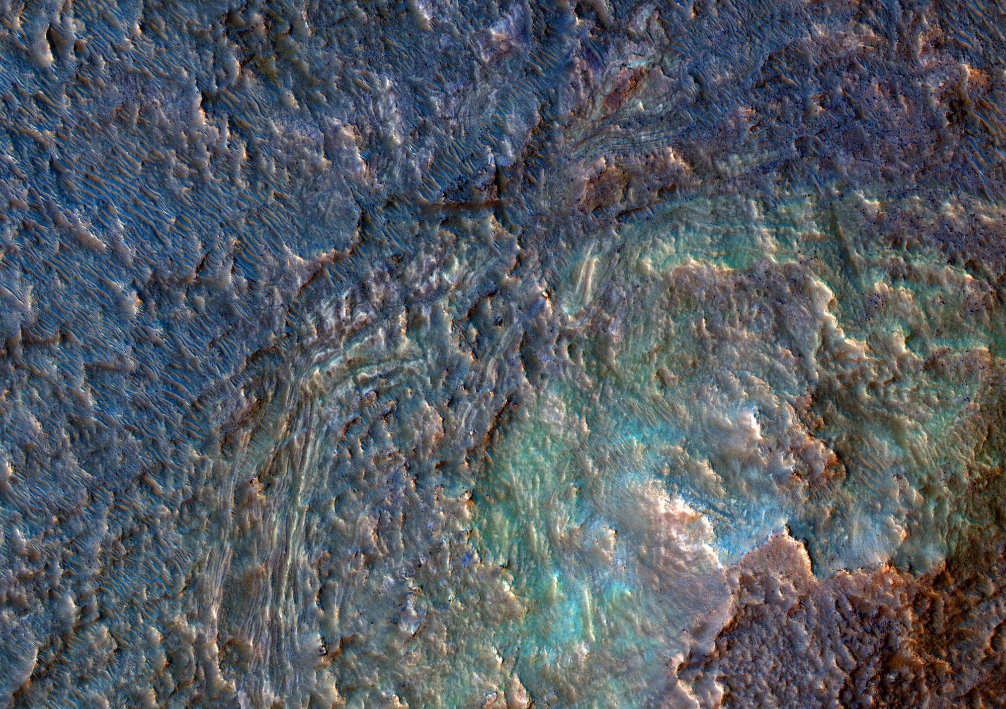
Cool image time! The picture to the right, rotated, cropped, reduced, and sharpened to post here, was taken on February 14, 2023 by the high resolution camera on Mars Reconnaissance Orbiter (MRO) and shows what the scientists have dubbed as “enigmatic knobs” located on the caldera floor of a Martian shield volcano.

The knobs themselves, while puzzling, aren’t that interesting on their own. They are no more than 100 to 200 feet high, and are relatively featureless. Since most lack a pit at their peaks, they are probably not some form of small volcanic vent, though this conclusion is uncertain. The location, at about 30 degrees south latitude, suggests the faint possibility of near surface ice, which could make these mud volcanoes, or a very specific Arctic-type permafrost mound dubbed pingos, but once again the lack of any central pit at their peaks makes these origins also doubtful.

What the knobs however revealed to me was a giant Martian shield volcano I had never noticed before, even though it was hiding in plain sight.
» Read more

The strange terrain in the basement of Mars

Strange terrain inside Hellas Basin
Click for original image.

I’ve posted numerous cool images about the weird and alien terrain found routinely in what is Mars’ death valley, Hellas Basin. Today is no different. The picture to the right, rotated, cropped, reduced, and sharpened to post here, was taken on February 23, 2023 to fill a gap in the schedule of the high resolution camera on Mars Reconnaissance Orbiter (MRO). Thus, it isn’t linked to any particular research, and its target was chosen by the camera science team almost at random.

What it shows is a strangely striated plain interspersed with rounded mesas and partly buried craters. The shape of the striations suggests that they were formed from wind blowing consistently from the north. This hypothesis is reinforced by the material that seems piled up at the base of the two bottom mesas, as if it was blown there.

Is ice or lava however?
» Read more

Glaciers or taffy on Mars?

Glaciers of taffy on Mars?
Click for full image.

Cool image time! The photo to the right, rotated, cropped, reduced, and sharpened to post here, was taken on November 28, 2022 by the high resolution camera on Mars Reconnaissance Orbiter (MRO). It was released on January 4, 2023 as a captioned image, with this caption by Alfred McEwen of the Lunar & Planetary Laboratory in Arizona:

The floor of the Hellas impact basin, the lowest elevation on Mars, remains poorly explored because haze often blocks it from view. However, we recently got a clear image, revealing the strange banded terrain. These bands may be layers or flow bands or both.

At first glance, these bands reminded me of the many glaciers found on Mars. McEwen however is being properly vague about the nature of these features, for a number of reasons illustrated by the overview map below.
» Read more

Glaciers in the Martian south latitudes

Glaciers in Mars' southern hemisphere
Click for full image.

Most of the glacier cool images I have posted in the past few years from the high resolution camera on Mars Reconnaissance Orbiter (MRO) have shown the obvious glacial features found in the northern hemisphere in that 2,000 mile long strip of chaos terrain at about 40 degrees latitude I dub “Glacier Country.”

Today’s glacier image to the right, cropped and reduced to post here, takes us instead to the southern hemisphere, into Hellas Basin, the death valley of Mars. The picture was taken on April 8, 2021, and in the full picture gives us a myriad of examples of glacial features. The section featured to the right focuses in on what appears to be an ice covered south facing slope, which in the southern hemisphere will get the least sunlight.

Think of the last bits of snow that refuse to melt after a big blizzard. They are always found in shadowed areas, which in the southern hemisphere would be this south-facing slope.

The overview map below shows how this location, marked by the small white rectangle, is inside Hellas Basin, at a low altitude comparable to the northern lowland plains. The feature is also a comparable latitude, 43 degrees south, to the glacier country of the north.
» Read more

A confused river of ice on Mars

A river of ice on Mars
Click for full image.

Cool image time! The photo to the right, rotated, cropped, and reduced to post here, was taken on March 4, 2021 by the high resolution camera on Mars Reconnaissance Orbiter (MRO). It shows what MRO’s science team labeled a “Landform in Source Region of Harmakhis Vallis.”

They are being very correct and careful with that label. The landform here is quite clearly reminiscent of a glacier, but because they don’t yet have confirmation of its watery nature, as good scientists they can’t call it that.

I however am a mere journalist, so I am free to speculate more wildly. Sure looks like glaciers to me, the ice flowing downhill from the left to the right and flowing around that central mound.

The overview map below gives a wider context, but also makes the behavior of the glaciers here far more puzzling.
» Read more

Boxwork in the basement of Mars

Polygon ridges in Hellas Basin
Click for full image.

Cool image time! The photo to the right, rotated, cropped, and reduced to post here, shows what resembles closely what in Earth caves are called boxwork, polygonal ridges sticking out from the bedrock and usually indicating cracks filled with harder material that resist erosion.

Taken by the high resolution camera on Mars Reconnaissance Orbiter (MRO) on March 23, 2021, what makes this boxwork especially interesting is its size and location. On Earth cave boxwork generally ranges from a few inches to a few feet across. Not only do these Martian ridges range from 100 feet to a half mile in length, they are located at the lowest point in Hellas Basin, the basement of Mars. In fact, this spot is as close as you can get to Mars’ Death Valley, as shown by the overview map below.
» Read more

Twisted taffy in the basement of Mars

Taffy on Mars
Click for full image.

Cool image time! The photo to the right, taken on March 7, 2021 by the high resolution camera on Mars Reconnaissance Orbiter (MRO) and cropped and reduced to post here, shows us an example of one of Mars’ strangest and most puzzling geological features, dubbed banded or “taffy-pull” terrain by scientists.

Taffy-pull terrain has so far only been found within Hellas Basin, Mars’ deepest impact basin and what I like to call the basement of Mars. Because of the lower crater count in this terrain scientists consider it relatively young, no more than 3 billion years old, according to this 2014 paper, which also notes

The apparent sensitivity to local topography and preference for concentrating in localized depressions is compatible with deformation as a viscous fluid.

At the moment what that viscous fluid was remains a matter of debate. Many theories propose that ice and water acting in conjunction with salt caused their formation, similar to salt domes seen on Earth. Other propose that the terrain formed from some kind of volcanic or impact melt process.

Almost all of the taffy terrain on Mars has been found in the deepest parts of Hellas Basin in a curved trough along its western interior, as shown by the light blue areas in the overview map below.
» Read more

Inexplicable ridges in Hellas Basin on Mars

Sinuous ridge in Hellas Basin
Click for full image.

Time for some more cool but mysterious Martian images! The photo to the right, rotated, cropped, and reduced to post here, is the first of two images today, both of which show the ridges but of a completely different nature. Both are located in Hellas Basin in Mars southern hemisphere.

This first picture was taken on September 4, 2020 by the high resolution camera on Mars Reconnaissance Orbiter (MRO), and shows a sinuous complex that resembles to a remarkable extent a set of river tributaries, but is instead a set of raised ridges rather than a canyon system.

Scientists have found more than 10,000 miles of such ridges in the northern hemisphere in Arabia Terra, the most extensive transition zone between the southern highlands and the northern lowlands, and have dubbed them fossilized rivers. From a 2016 press release:

The inverted channels are similar to those found elsewhere on Mars and Earth. They are made of sand and gravel deposited by a river and when the river becomes dry, the channels are left upstanding as the surrounding material erodes. On Earth, inverted channels often occur in dry, desert environments like Oman, Egypt, or Utah, where erosion rates are low – in most other environments, the channels are worn away before they can become inverted. “The networks of inverted channels in Arabia Terra are about 30m high and up to 1–2km wide, so we think they are probably the remains of giant rivers that flowed billions of years ago. Arabia Terra was essentially one massive flood plain bordering the highlands and lowlands of Mars. We think the rivers were active 3.9–3.7 billion years ago, but gradually dried up before being rapidly buried and protected for billions of years, potentially preserving any ancient biological material that might have been present,” added Joel Davis.

Nor are such features on Mars limited to Hellas and Arabia Terra. For a particularly spectacular feature in the cratered highlands see this 2019 post.

The origin of these sinuous ridges in Hellas might have a similar origin as these other fossilized rivers. At present the bottom of Hellas, the deepest basin on Mars, is a place with little signs of ice. In the past there is evidence that lakes once existed here, so we cannot rule out water as a cause.

At the same time, Hellas was formed by a gigantic impact. One cannot dismiss the possibility of a volcanic origin, impact melt left over from the heat of that crash.

Today’s second ridge complex in Hellas looks far different.
» Read more

The freaky floor of Mars’ Hellas Basin

The perplexing floor of Hellas Basin
Click for full image.

Today’s cool image takes us to the Death Valley of Mars, Hellas Basin, a place I like to call the basement of Mars. The photo to the right, cropped and reduced to post here, was taken by the high resolution camera on Mars Reconnaissance Orbiter (MRO) on September 28, 2020, and gives us another example of the very strange and inexplicable geological formations that are often found on the floor of Hellas.

The picture was taken not as part of any particular research project, but somewhat randomly for engineering reasons. In order to maintain the proper temperature of MRO’s high resolution camera, it must take images in a regular cadence. When large gaps in time occur between requested images, the camera team then picks locations to fill those gaps, sometimes randomly, sometimes based on a quick review of earlier wide angle images.

Sometimes these “terrain sample” images are quite uninteresting. More often they hold baffling surprises.

I think the photo to the right falls into the latter category. Though the terrain covered by the full image is largely flat and lacking in large features, the surface is strewn with perplexing small details.

The light streaks might be dust devil tracks, but why are they light here when such tracks are routinely dark everywhere else on Mars? What formed the many parallel small ridges? What caused the smooth solid patch near the photo’s center top? And why do the ridgelines at the western edge of that patch run in almost a perpendicular direction to the other ridges?

All a mystery, but then the floor of Hellas Basin is filled with such mysteries. Below is a list of some other cool images of the floor of Hellas, all weird and mystifying. Also below is an overview elevation map of Hellas Basin, with darker blue indicating the lowest elevations. The white cross marks the location of today’s photo.
» Read more

Terby Crater and its drainages into Mars’ basement

Channels in Terby Crater on Mars
Click for full image.

Cool image time! Over the past few years, in my endless rummaging through the archive of high resolution images from Mars Reconnaissance Orbiter (MRO) I have posted a lot of photos of meandering channels of all kinds, most of which evoke to Earth eyes canyons eroded by flowing water. (This September 2020 cool image is just one of the more recent examples.)

Today’s cool image is another example, but in this case it is only a very small part of a very large drainage basin that is more than a hundred miles across and extends at least that far southward into the basement of Mars, Hellas Basin, the place on Mars with the lowest elevation.

The photo to the right, rotated and reduced to post here, was taken on September 12, 2020 by the high resolution camera on MRO. I normally wouldn’t post the whole image, but to crop it would mean you wouldn’t get the sense of extensive nature of this drainage. Downhill is to the south. The channel apparently passes through three or four stages. First, its northernmost section is in a wide canyon, the floor of which resembles glacial debris (though with a latitude of 27 degrees south this is a bit too close to the equator for ice). More likely we are looking at wind-blown sand and dunes being pulled downhill in the floor of the canyon.

This first canyon is also actually a gap in the rim of a 13-mile-wide unnamed crater. See this MRO context camera image for a wider view.

Next, the drainage becomes a series of meandering small interweaving channels, resembling the channels often seen in beach mud as the tide goes out.

Finally, the channels head into a gap to fall over a sloping cliff into lower terrain.

Nor these stages entirely linked. The first glacial-like stage exiting the gap in the crater appears to drain to the southeast, while the second seems to emanate from what appears to be a very faint small crater now partly buried. Both head south toward the gap, but the path of the eastward drainage appears less obvious. Some of it flowed westward to join the meandering channels but some also appears to work its way south more to the east.

This one image shows a lot of channels, but it is only a very small slice of this whole drainage system. In fact, we are looking here at only one strip of the interior slope of the northern rim of 108-mile-wide Terby Crater.

The overview map below gives the larger context. Terby Crater sits on the northern border of Hellas Basin, which in itself extends another 1,500 miles to the south. From this point the drop in elevation into Hellas is almost four miles.
» Read more

The strange squashed ridges at the basement of Mars

Squashed ridges at the basement of Mars
Click for full image.

Overview map

Cool image time! The photo on the right, cropped and reduced to post here, was taken by the high resolution camera on Mars Reconnaissance Orbiter (MRO) on April 9, 2020, and shows the very weird and very packed ridges and layers that are found routinely at the deepest part of Hellas Basin, what I have dubbed the basement of Mars.

Be sure to click on the image to see the full photograph. There’s lots more strangeness to see there. And be sure to read my post in the second link, which highlights a similarly strange set of packed ridges, and where I note:

This is the basement of Mars, what could be called its own Death Valley. The difference however is that unlike Death Valley, conditions here could be more amendable to life, as the lower elevation means the atmosphere is thicker.

The context map to the right shows Hellas, with the location of today’s image indicated by the white box, close to basin’s lowest point, more than five miles below the basin’s rim. Overall the Hellas Basin is about the size of the western United States, from the Mississippi River to the Pacific Ocean. It is believed that the entire basin was created by a single gigantic impact that occurred about four billion years ago when the solar system’s inner planets were undergoing what has been labeled the Late Heavy Bombardment.

The specific process that formed these ridges, dubbed honeycomb terrain by scientists, remains unknown however. There are of course theories, none of which are very convincing. Here’s mine, as outlined in the previous post:
» Read more

The slowly changing dunes of Mars

Map of Mars

In order to better understand the climate and geology of Mars, scientists need to study how the thin Martian atmosphere causes changes to the planet’s numerous sand dunes. To do this, they have been using the high resolution camera on Mars Reconnaissance Orbiter (MRO) to periodically snap photos of the same places repeatedly over time, to track any changes that might occur.

Recently the monthly download dump of images from MRO included one such location in the northwest quadrant of Hellas Basin, what I call the basement of Mars because it the planet’s lowest point. The uncaptioned image was taken on May 20, 2019 and was titled “Hellas Region Sand Dune Changes.” A review of past images shows that MRO has taken pictures of this location several times in the past, in 2011 and in 2017. All these images were taken during the Martian autumn season, and were taken to see if over time there were any significant changes to the dunes due to winds.

My superficial comparison of the 2011 and 2017 images does not show much obvious change. There could be small changes that my quick review did not spot, and there is also the strong possibility that the entire dune field could have shifted as a unit over those three Martian years, a change that would require a more detailed analysis beyond my technical capabilities. Click on both links, put the photographs in separate tabs, and switch quickly between them to see if you can spot any differences.

Comparing the 2011 and 2019 images however shows some significant changes, most of which I think are due to the 2018 global dust storm. Below is that comparison.
» Read more

Terraced and banded hills on Mars

Banded or terraced hills in eastern Hellas
Click for full image.

Cool image time! In my review of the most recent download of images from Mars Reconnaissance Orbiter’s (MRO) the high resolution camera, I found a very startling (and cool) image of some dramatic terraced Martian hills, taken on July 30, 2019. I wanted to post it here, but decided to first do some more digging, and found that an earlier image, taken in 2017, showed more of this particular hill. It is this earlier image posted to the right, cropped and reduced.

Don’t ask me to explain the geology that caused this hill to look as it does. I can provide some basic knowledge, but the details and better theories will have to come from the scientists who are studying this feature (who unfortunately did not respond to my request for further information).

What I can do is lay out what is known about this location, as indicated by the red box in the overview map below and to the right, and let my readers come up with their own theories. The odds of anyone being right might not be great, but it will be fun for everyone to speculate.
» Read more

Crater on the Basement of Mars

Crater in the bottom of Hellas Basin
Click for full image.

Cool image time! In the July release of images from the high resolution camera of Mars Reconnaissance Orbiter (MRO) was the image to the right, cropped to post here, showing what I suspect is a relatively young crater located in the lowest part of Hellas Basin, what I call the bottom of Mars.

Though this crater is not located at the lowest point in Hellas, it is not far off from there. What makes it important to geologists are two facts. First, there are not a lot of craters in Hellas, which helps indicate it is a relatively young feature. Second, and more important, the impact has made accessible material from below the surface, indicated by the different colors in this image. From this information they can better constrain their theories about the Basin’s formation and where it fits in Mars’s overall geological history.

Make sure you take a look at the full photograph by clicking of the image, and compare it with the earlier Hellas Basin images I posted here. The surface of Hellas appears to have a lot of flow features, as if it was laid down by volcanic activity, or by the motion of water that covered it. In either case that would explain the overall lack of craters.

A river valley floor on Mars

Overview of Reull Valles region

Today’s cool image focuses in on a Mars Reconnaissance Orbiter (MRO) uncaptioned photograph taken of the valley floor of Reull Vallis, a meandering canyon that drains into Hellas Basin, the bottom of Mars.

The image on the right is not that photograph. Instead, it is an overview of the area surrounding it. The image location is indicated by the black cross, dead center within the floor of Reull Vallis itself. This valley, as well as Dao and Niger to the northwest but lower in elevation are all thought to have been formed from flowing water, all of which apparently drained from the east and to the west into Hellas Basin.

This last detail is very important and bears repeating before looking at today’s subject image. The river that formed Reull Vallis flowed from the east to the west. Now for that picture.
» Read more

The basement of Mars

Hellas Basin ripples

Cool image time! The photo on the right, cropped and reduced to post here, was taken by the high resolution camera of Mars Reconnaissance Orbiter (MRO) on May 2, 2018, and shows some very strange ripples and erosion features in one of the lowest elevation locations on Mars, inside Hellas Basin. If you click on the image you can see the full photograph, at full resolution. There are a lot of strange features here, so make sure you take a look at it. The ripples highlighted in the image are between what appear to be three lower basins, and seem to my eye to be ridges created as liquid ebbed and flowed in the basins, depositing material at the shoreline at repeatedly higher and lower levels.

hellas basin

This particular location is not only in Hellas Basin, but it is also located in the deepest part of Hellas, a curved valley located in the basin’s northwest quadrant, as shown by the darker areas in the overview image to the right. The red boxes are other MRO high resolution images, with the cross indicating where this image is located.

This is the basement of Mars, what could be called its own Death Valley. The difference however is that unlike Death Valley, conditions here could be more amendable to life, as the lower elevation means the atmosphere is thicker. The ripples also suggest that liquid water might have once been here, a supposition supported by other low area images of Hellas Basin, most of which show a flattish dappled surface that to me resembles what one would think a dry seafloor bed would look like. The image in this second link also shows what looks like ghost craters that over time became partly buried, something one would also expect to happen if they were at the bottom of a lake, though this could also happen over time on Mars with wind erosion and the movement of dust.

It is also possible that these features come from lava events, so please take my theorizing here with a great big grain of salt. At the same time, recent results have found evidence of paleo lakes scattered all along the eastern rim of the basin, reinforcing the possibility that these were water filled lakes once as well.

Nonetheless, the ripples in the first image above are truly fascinating, as it is clear that at the highest peaks erosion has ripped those peaks away, leaving behind a hollow shaped by the ripples themselves. These features remind me of some cave features I have seen, where mud gets piled but by water flow, and then is over time covered with a crust of harder calcite flowstone. Later, water then washes out the mud underneath, leaving the curved flowstone blanket hanging in the air.

Here in Hellas Basin it looks like something similar has happened, except that at these peaks the outside crust got broken away, allowing wind to slowly suck out the material underneath, leaving these ripple-shaped pits. Whether it was liquid water or lava that helped create these features, the geology left behind is both beautiful and intriguing. I wonder at the chemical make-up of the crust as well as the materials below. And I especially wonder if there are water sources buried within Hellas Basin.

The known ice cliffs on Mars

Last week there was a big NASA story about the discovery of eight locations on Mars where the evidence strongly suggests that these spots have cliff faces with exposed layers of water ice.

The press release however did not provide an overview about where those eight locations were. Only two locations were given, one for a scarp in Milankovič Crater in the northern hemisphere, and one in an area called Promethei Terra, located in the remote cratered highlands in the southern high-mid-latitudes.

The location of known ice scarps on Mars

After much digging (and some assistance from John Batchelor) I was finally able to obtain the latitudes and longitudes of all 8 locations. All but the scarp in Milankovič Crater crater (shown by the white dot north of Olympus Mons) are located in the white rectangular box shown to the south and east of Hellas Basin, the area with Mars’ lowest elevation. This part of Mars is not well imaged with the high resolution camera on Mars Reconnaissance Orbiter (indicated by the fewer number of red squares in the image), mostly because it appears relatively boring from a distance. Nothing appears to be there for hundreds and hundreds of miles except craters, sand, and sand dunes..

The discovery of these scarps in this area however changes the picture. It suggests that cratered highlands that surround Hellas Basin, including those close to the planet’s equator, could contain similar buried layers of ice. More research is necessary to pin down more locations, especially those closer to the equator where conditions might be more hospitable for a colony.

Moreover, educated readers of Behind the Black have previously noted that because of Hellas Basin’s low elevation the air pressure there is thicker, and therefore the location has some advantages as a potential colony location. These ice scarps raise the value of Hellas Basin considerably, as they suggest that such layers could easily be exposed as you descend into Hellas Basin. If such layers are exposed on the northern flanks of the basin, they would be at latitudes of around 25 to 30 degrees south, a much more friendly latitude for settlement.

The Painted Desert of Mars

Mars Reconnaissance Orbiter released this picture yesterday of what the Orbiter’s scientists have labeled “The crazy floor of Hellas Basin.” Below you can see a cropped image of only one part of the large higher resolution image. The NASA caption says that the wild colors probably “indicate that diverse minerals are present,” meaning that any settlers of the red planet will probably take a close look at this location with the reasonable hope of finding the resources they need to colonize a planet.

To me, these colors also indicate that this place on Mars would probably one of its most popular tourist spots. As I look at the image my eye instinctively wants to trace out the best trail route along the ridges and down into the gullies in order to give hikers the best view of this colorful terrain.

Hellas Basin