The vast Martian plains of lava

The vast Martian lava fields
Click for original image.

Cool image time! The picture to the right, rotated, cropped, reduced, and sharpened to post here, was taken on January 31, 2024 by the high resolution camera on Mars Reconnaissance Orbiter (MRO). Labeled “Lava Embaying Highlands Ridge”, it shows an alcove along a ridgeline that appears filled with material, in this case solid lava.

If you look closely at the ridgeline, you can see several dark streaks on its southern slopes. These streaks could be one of two unique Martian features that remain unexplained. They could be slope streaks, which occur randomly through the year and fade with time, or recurring slope lineae, which occur seasonally at the same locations. In either case, though the streaks look like avalanches, they don’t change the topography, have no debris piles at their base, and even sometimes flow uphill for short lengths. Though there are a number of theories for their formation, many involving dust, none has been accepted as confirmed.

This location and its lava however are the stars of this picture, for a number of reasons, all revealed by the overview map below.
» Read more

Mapping the layered geology of Mars

Mapping the layers on Mars
Click for original image.

Today’s cool image is an update of a previous cool image from July 2021. Then, I posted a captioned high resolution Mars Reconnaissance Orbiter (MRO) photo of the many terraced layers within a 13-mile-wide crater dubbed Jiji and located in Arabia Terra, the largest transition zone between the Red Planet’s northern lowland plains and the southern cratered highlands. At that time the caption noted that research was on-going to see if the same layers could be identified in two other nearby craters, Banes and Sera, and thus use that data to extrapolate the long term geological history of this region on Mars.

Today’s cool image to the right, rotated, cropped, reduced, and enhanced to post here, was taken on January 4, 2024 as part of this research, and shows the layers in 18-mile-wide Sera crater, located only about ten miles to the east of Jiji crater. The highest mesa near the bottom of the picture is about twenty feet high on its southern side, but about 140 feet high to the north. The difference is because the crater floor under the mesa is sloping downward to its lowest point to the north.
» Read more

Scientists: Mars’ mysterious slope streaks and seasonal recurring lineae are caused by dust

Massive flow on Mars
A typical Martian slope streak.

On Mars there are two mysterious features that are somewhat similar but entirely unique to the Red Planet, and for years have baffled planetary geologists as to their origins.

One feature is called slope streaks, which appear randomly year-round as either dark or bright streaks on slopes. They resemble avalanches, except that they do not change the topography, have no debris piles at their base, and sometimes travel along that topography, sometimes even going uphill for short distances. Over time these streaks then fade.

The other feature is called recurring slope lineae, because though they look like slope streaks, they are not random but appear seasonally at the same places each year. Lineae are also always dark.

Scientists have proposed many theories to explain both, with most theories involving some form of water process, either the seepage of brine from below or water vapor causing the Martian surface dust to flow, like droplets on a car windshield. None of these theories has been confirmed, or entirely accepted.

Two studies at this week’s 55th annual Lunar and Planetary Science Conference in Texas have both concluded that water is not a factor in the formation of either phenomenon. Instead, both papers propose a much simpler explanation: Wind and blowing dust interact to cause small dust avalanches.
» Read more

A Martian tadpole

Overview map

A Martian tadpole
Click for original image.

Cool image time! The picture to the right, rotated, cropped, reduced, and sharpened to post here, was taken on December 28, 2023 by the high resolution camera on Mars Reconnaissance Orbiter (MRO).

The white dot on the overview map above marks the location, with the rectangle in the inset marking the area covered by the picture. The science team labels this “inverted features,” a more vague way to describe the feature geologists dub “inverted channels.” The flow of a river or glacier acts to harden and increase the density of the channel bed. Later, the water or ice disappears, leaving just the canyon.

Even later, erosion begins to wear away the surrounding terrain. Because the canyon floor is now harder than that surrounding terrain, that floor is more resistent to erosion, and eventually becomes ridge following the exact same path as the long gone river or glacier.

This is what we have here, with this inverted channel, which is about five miles long, once draining into the deeper eroded valley to the south.

The location is at 38 degrees north latitude and inside the 2,000-mile-long mid-latitude region I dub glacier country, because almost every image shows evidence of glaciers or ice flows on the surface. This picture however is a rare exception. The features in this picture instead appear to be bedrock, something that is rarely seen in the canyons and craters in glacier country. It is beyond my pay grade however to explain why this spot lacks such features. Or it could be the near surface ice here looks so much like bedrock I am misinterpreting the picture.

The strange surface of the perennial dry ice cap at Mars’ south pole

The strange surface of Mars' dry ice cap
Click for original image.

Cool image time! The picture to the right, cropped to post here, was taken on January 24, 2024 by the high resolution camera on Mars Reconnaissance Orbiter (MRO). It shows a region about 180 miles from the south pole of Mars.

This terrain is intriguing because is the pattern of ridges that cover it entirely. I have simply cropped the original image to show these ridges in highest resolution. The full image shows them covering a region much larger than this.

What are we looking at? Because it is near the pole, it is likely that the black splotches are caused by carbon dioxide gas breaking through the winter mantle of dry ice that covers the poles during the winter months and then sublimates away, from the bottom, each spring. As the dry ice turns to CO2 gas that gas is trapped, until it can find a weak spot in the overlying mantle. When the pressure builds enough, the mantle breaks, the gas escapes, and as it does so it deposits the dark dust around the breakage. That dust fades as the mantle disappears.

Sounds good, eh? Not so fast.
» Read more

The really really strange landscape of Cydonia on Mars

Some really strange terrain on Mars
Click for original image.

Cool image time! The picture to the right, cropped, reduced, and sharpened to post here, was taken on January 3, 2024 by the high resolution camera on Mars Reconnaissance Orbiter (MRO), and shows what the camera team describes merely as “landforms.”

In truth, these features, as well as almost everything in the surrounding terrain beyond the edge of this picture, are possibly the weirdest geological features on Mars. The two mounds, no more than fifteen feet high at the most, resemble pimples. The rough ground to the north actually appears to be some flow that worked its way around the mounds, as indicated by the arrows. The crack to the southeast of the two mounds appears to be an extension of a fault line that cuts through the center of the larger mound, suggesting the mound is some form of eruption belching out of that fissure.

That the latitude is 42 degrees north, these weird features all suggest some form of ice-based volcanic activity, because the ground here is probably impregnated with ice.

As for the bridge connecting the two mounds, who knows what caused it?
» Read more

A Martian cliff of ash, flushed by wind

A Martian cliff of ash flushed by wind
Click for original image.

Cool image time! The picture to the right, rotated, cropped, reduced, and sharpened to post here, was taken on December 27, 2023 by the high resolution camera on Mars Reconnaissance Orbiter (MRO). Described merely as an “exposed scarp” by the science team, this cliff edge is actually much more.

First some basic details. The elevation drop from the plateau down to the base of this cliff is about a thousand feet. The material that forms this plateau, scarp, and its base is all volcanic ash. The thicker sections of ash has caused its lower levels to compress, harden into a kind of sandstone. Near the surface however it is more friable, and like sandstone can break apart somewhat more easily.

The prevailing winds at this site are generally blowing to the south, but beginning to turn to the east, which explains the northwest to southeast orientation of the features.

The best analogy I can come up with to explain the erosion of this scarp is as follows: Imagine a deposit of dry mud a few inches thick on pavement. Take a leaf blower and blow at it hard, always in one direction. Eventually the outer edge will break up and blow away, leaving a sharp edge, that will also retreat with time as the wind continues to blow.

Here the winds are eroding that cliff, causing periodic avalanches which dissolve into sand that then blows away, leaving no debris pile at the base of the cliff. The ridges indicate harder material, that breaks away last, which is why there are some ridgelines extending outward from the scarp in line with these ridges. At the same time, these ridges of harder ash still break up with time, as some are cut off suddenly at the cliff edge.
» Read more

A recent volcanic eruption on Mars?

A recent volcanic eruption on Mars?
Click for original image.

Cool image time! The picture to the right, cropped, reduced, and sharpened to post here, was taken on December 16, 2023 by the high resolution camera on Mars Reconnaissance Orbiter (MRO). The science team labels the two darkened patches in the picture “plume-like features,” suggesting that the dark material was eruptive material thrown out from the depressions in a volcanic venting, that then settled on the nearby surrounding terrain.

Is that a correct interpretation? It is certainly strengthened by a different feature located about 550 miles to the northwest that looks almost the same. There, researchers theorize that the dark material surrounding a surface fissure was caused by a small volcanic event that occurred somewhere between 50,000 to 210,000 years ago. For that other location, scientists concluded as follows:

After careful comparison of this symmetrical dark feature with other dark wind-caused streaks in this region, the scientists concluded that it was not caused by wind, but is the remains of a relatively recent volcanic eruption that laid down a thin layer of material only about one foot thick.

» Read more

Frozen lava rapids on Mars

Frozen lava rapids on Mars
Click for original image.

Cool image time! The picture to the right, rotated, cropped, reduced, and sharpened to post here, was taken on October 6, 2023 by the high resolution camera on Mars Reconnaissance Orbiter (MRO), and shows a spot on Mars where lava was squeezed between and around some small peaks as it flowed quickly south, flooding all the low areas in this landscape.

The science team describes the features in the full image as “streamlined”, a description that is literally accurate. As this “stream” of lava rushed past, it “lined” the higher terrain, carving it into tear-dropped shapes.

In the color strip, note the blueish spots at the northern base of the 400-foot-high hill. According to the science team’s explanation [pdf] of the colors in MRO images, “Frost and ice are also relatively blue, but bright, and often concentrated at the poles or on pole-facing slopes.” The picture was taken in summer, so if these bright spots are frost or ice, it suggests they are well shaded from sunlight in those north-facing alcoves. This location is only 9 degrees north of the equator, so finding any near surface ice here is highly unlikely. That frost might exist however is intriguing, to say the least.
» Read more

Martian gullies caused by glacial and water erosion

A gully on the north rim of Niquero Crater
Click for original image.

Cool image time! The picture to the right, rotated, cropped, reduced, and sharpened to post here, was taken on December 23, 2023 by the high resolution camera on Mars Reconnaissance Orbiter (MRO).

The image shows us the north interior rim of 7-mile-wide Niquero Crater on Mars. From the high to the low points the elevation difference is about 2,500 feet, with a steep downhill slope averaging about 18 degrees. The terrain appears to show several avalanche collapses that pushed lower material out of the way, though at the bottom where that material has been pushed aside there is no obvious large debris pile.

The science team labels this image simply “volatiles and gullies”, a label that carries a host of significant information. These gullies, which were among the earliest found by Mars Global Surveyor in the late 1990s, were the first evidence that the surface of Mars had a lot of near surface ice. It is for this reason that this relatively small crater on Mars has a name. Most craters this small remain unnamed, but the gullies on Niquero’s north slopes required more study, and thus the crater was given a name.

Subsequent orbital imagery has now shown that craters like Niquero, located in latitudes higher than 30 degrees, quite often are filled with glacial debris. In fact, the material that these avalanches pushed aside at the base of the slope is that glacial material, protected by a thin layer of dust and debris. The avalanche essentially disturbed that protected layer, and thus the debris pile (made up mostly of ice) sublimated away when warmed by sunlight. Thus. no big debris pile.

The gullies tend to be on the pole-facing slopes. Scientists believe they are the remnant evidence of ancient glaciers that grew on these slopes because they were protected from sunlight. In subsequent eons, when the climate on Mars changed, those glaciers collapsed, leaving behind the gullies we see now.
» Read more

Alternating dark and light terraces inside Valles Marineris

Overview map

Alternating dark and light layered terraces in Valles Marineris
Click for original image.

Cool image time! The picture to the right, cropped and enhanced to post here, was taken on October 9, 2023 by the high resolution camera on Mars Reconnaissance Orbiter (MRO), and shows what appear to be the somewhat typical terrain at this location, in a part of the giant Martian canyon Valles Marineris dubbed West Candor Chasma. For example, I featured similar swirls in August 2022 at a place only about six miles to the east, that spot indicated by the green dot on the overview map above. The white dot marks the location of today’s image.

So, what are we looking at? The elevation drop from the high and low points is only about 180 feet, but in that short distance it appears there are more than two dozen visible layers, and those layers form terraces that alternate between bright and dark material.

The shape of the swirls also suggest that a flow of some kind, either water, ice, or wind, moved from the northwest to the southeast, carving these terraces as it descended the stair steps downward. It is also just as likely that we are seeing repeated lava flows going downhill to the southeast, each even laying another layer on top of the preceeding one. And it is also possible that we are looking at a combination of both.

The alternating dark and light layers suggest that each dark layer was an event that put down dark material, such as volcanic dust, that was subsequently covered with light material, with this process repeating itself many times over the eons.

That the floor of this part of Valles Marineris is uniquely covered in this manner is in itself intriguing. Why here, and not elsewhere within the canyon?

The alien surface of Mars

The alien surface of Gediz Vallis
Click for original image.

Overview map
Click for interactive map.

Cool image time! The picture above, brightened slightly to post here, was taken on February 15, 2024 by the right navigation camera on the Mars rover Curiosity. It looks east at the looming cliff face of the mountain Kukenan that the rover has been traveling beside for the last six months. On the overview map to the right the yellow lines indicate roughly the area covered by this picture. The blue dot marks Curiosity’s present position, while the green dot marks its position on February 5, 2024. As you can see, the rover is making slow but steady progress uphill into Gediz Vallis.

This image illustrates the alien landscape of Mars quite beautifully. First, there is absolutely no life in this picture. On Earth you would be hard pressed to find any spot on the surface that doesn’t have at least some plant life.

Second, there is the rocky layered nature of this mountain. When the Curiosity science team first announced its future route plans (the red dotted line) to drive into this canyon back in 2019, the orbital images of these layers from Mars Reconnaissance Orbiter (MRO) had suggested the terrain here would be reminiscent of The Wave in northern Arizona, a smooth series of curved layers smoothed nicely over time by the wind.

As you can see, there is no smoothness here. Instead, every single layer here is infused with broken rock, suggesting that each layer is structurally weak. As erosion exposes each, the layer breaks up, crumbling into the chaos in this picture. The curved nature of the terrain at the bottom of the picture however does suggest that some sort of flow once percolated down this canyon, either liquid water or glacial ice, carving the layers into this curved floor.

The shoreline of a Martian lava sea

The shoreline of a Martian lava sea
Click for original image.

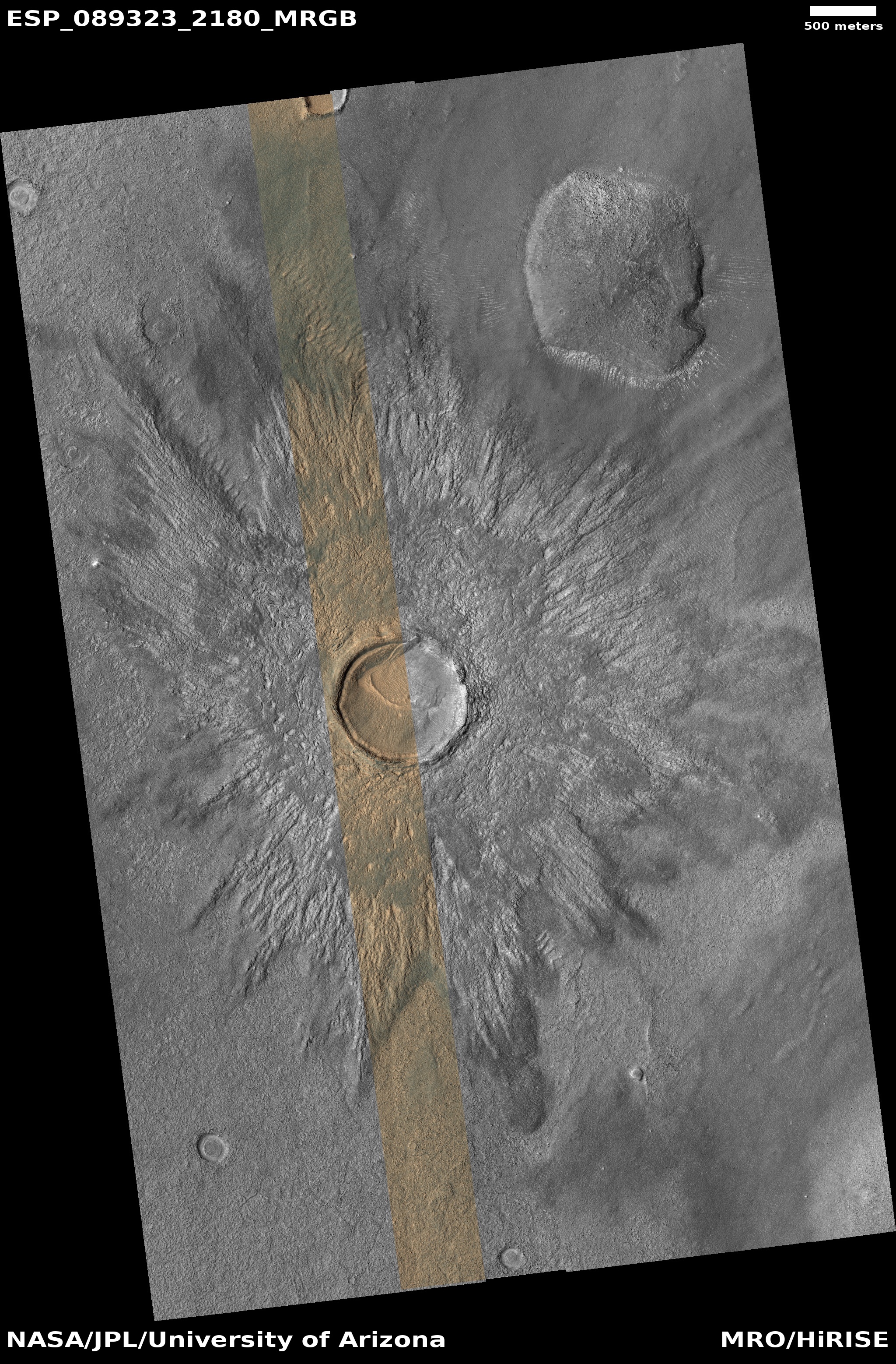
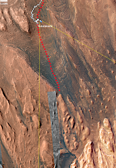
Cool image time! The picture to the right, cropped, reduced, and enhanced to post here, was taken on October 2, 2023 by the high resolution camera on Mars Reconnaissance Orbiter (MRO).

The science team labeled this a “lava margin.” The darker material on the right is apparently a newer deposit of lava, flowing on top of the lighter lava on the left. The newer deposit is only about three feet thick, so it had to have flowed fast almost like water to cover this large area with such a thin layer before freezing. Even so, this new lava layer has a roughness greater than the older layer below it. Either the older layer is smoother because of erosion from wind over eons, or the lava in these two layers was comprised of slightly different materials that froze with different textures.

The small ridges appear to be wrinkle ridges, created when material shrinks as it freezes.

This margin marks the edge of a very large flood lava event, as illustrated by the overview map below.
» Read more

Spiders on the rim of a Martian crater

Spiders on the rim of a Martian crater
Click for original image.

Cool image time! The picture to the right, cropped to post here, was taken on December 29, 2023 by the high resolution camera on Mars Reconnaissance Orbiter (MRO). It shows strange spidery formations on the rim of a 17-mile-wide crater about 500 miles from the south pole of Mars.

Scientists think these spider features are formed due to the seasonal cycle on Mars. In the winter at the poles the carbon dioxide in the atmosphere falls as snow in the polar regions, creating a thin dry ice mantle that covers everything. When spring arrives, sunlight goes through the clear mantle to heat its base, causing that dry ice to sublimate into gas that is trapped below the mantle. Eventually that mantle cracks at a weak point and the gas escapes, spewing dark dust on its top. By summer the mantle is entirely gone, and the black splotches disappear as they blend back into the same colored ground.

At the south pole the ground appears to be firmer and more structurally sound than at the north pole. The trapped gas appears to travel upward along the same tributary paths to the same escape points each year, thus carving these spidery features that are permanent features.
» Read more

Martian dunes with strange splotches

Martian dunes with splotches

Cool image time! The picture to the right, cropped to post here, was taken on December 20, 2023 by the high resolution camera on Mars Reconnaissance Orbiter (MRO). It shows what the science team labels as “Dunes with Blotches.”

The blotches, or as I call them splotches, are the round dark patches on dunes themselves. Though their darkness is reminiscent of the dark patches that appear as spider features in the south polar regions of Mars, there are problems linking the two. The spiders form when the winter mantle of dry ice that falls as snow begins to weaken when the Sun reappears in the spring. Sunlight travels through the clear dry ice to warm the base of the mantle, causing it to sublimate into carbon dioxide gas. That gas however is trapped at the base, and only escapes when the thin mantle cracks at weak points. As the gas puffs out it carries with it dust, which leaves dark patches on the surface that disappear when the mantle disappears entirely by summer.

In the southern hemisphere at the poles the ground is somewhat stable, so the trapped gas appears to travel along the same paths each year to the same weak spots. This in turn causes it to carve spidery patterns in the ground, like river tributaries, except here the tributaries of gas flow uphill to their escape point. At the north pole the ground is not as stable. Instead we have many dunes, so that the dry ice mantle sublimates away at different places each year. There is no chance to form such spider patterns over time.

Making these splotches more puzzling is the season. This picture was taken in the winter, at a time one would think no dry ice is sublimating away.
» Read more

More hiking possibilities on Mars!

More hiking possibilities on Mars
Click for original image.

Cool image time! The picture to the right, rotated, cropped, reduced, and sharpened to post here, was taken on September 27, 2023 by the high resolution camera on Mars Reconniassance Orbiter (MRO). Dubbed a “terrain sample” by the science team, this picture was likely chosen not as part of any specific research project but to fill a gap in the camera schedule so as to maintain that camera’s proper temperature.

When the team needs to do this they try to pick interesting targets. In this case the location is the region of many many parallel north-south fissures that extend for more than 800 miles south of the giant but relative flat shield volcano Alba Mons. These fissures are grabens, cracks formed when underground pressure pushed the ground up and caused it to spread and crack.

What attracted me to this picture is the ridgeline. It struck me as a wonderful place to hike. I have even indicated in red the likely route any trail-maker would pick to go from the valley below up onto the ridge, and then along its knifelike edge to the south. The height of the cliff down to the east valley averages about six hundred feet, guaranteeing beautiful scenery the entire length.
» Read more

A small Martian volcano?

A small Martian volcano?
Click for original image.

Cool image time! The picture to the right, cropped, reduced, and sharpened to post here, was taken on December 21, 2023 by the high resolution camera on Mars Reconnaissance Orbiter (MRO). The science team labeled it a “fresh crater”, but that description I think is misleading, as it implies a recent impact.

The crater does not look like a fresh impact crater to me. Such things on Mars usually appear very dark, as the impact dredges up dark material. This crater is not dark. More significant is the crater itself. The small 300-foot-wide inner crater, surrounded by a circular plateau and all sitting inside the larger 1,200-foot-wide crater is completely unique compared to any impact crater I have ever seen. Impacts in soft material, such as ice-impregnated ground, can cause concentric ripple rings, but they don’t look like this.

Instead, this crater more resembles the caldera of a volcano, where subsequent eruptions can produce overlapping depressions at the volcano peak. (See for example this picture of Olympus Mons.)

Moreover, the crater sits on top of a peak approximately 300 feet high. While impacts in ice-impregnated ground on Mars can produce splash aprons as seen here, the crater usually sits at about the same elevation as the surrounding terrain, not at the top of a peak. This peak suggests the apron was forned not by a splash but repeated flows coming down from the top.
» Read more

A spot where the surface of Mars cracked

The spot where Mars cracked
Click for original image.

Cool image time! The picture to the right, rotated, cropped, reduced, and sharpened to post here, was taken on September 14, 2023 by the high resolution camera on Mars Reconnaissance Orbiter (MRO). It shows a small section of the Cerberus Fossae cracks, a parallel series of cracks that stretch more than 700 miles across the volcanic plains of Mars.

These cracks formed when the ground spread apart, creating a void in which the surface collapsed. You can see this process illustrated quite clearly by the crater in the lower right, as indicated by the arrow. The crater had existed prior to the crack. When the ground split and collapsed, only the northeast quadrant of the crater was destroyed.

These cracks might also have been the source of Mars’ most recent large volcanic event, as shown by the overview map below.
» Read more

Have these Martian dunes changed in sixteen years?

Comparing two MRO images taken 16 years apart
Click here and here for the original images.

Overview map

Cool image time! The two pictures above, both rotated, cropped, reduced, and enhanced to match and to post here, were taken by the high resolution camera on Mars Reconnaissance Orbiter (MRO) sixteen years apart. The first, on the left, was taken on February 23, 2007, while the second, on the right, was taken on November 1, 2023.

What drew me to both images was the label for the second: “Dune Change in Arabia Region Crater.” To find out if this image had revealed any changes in the dunes I went back and found the earliest MRO picture of this location, and sized and enhanced the dunes in both to match.

Do you see any changes? I don’t. However, that really means nothing. These are not the highest resolution versions that MRO obtains, and a very careful comparison of those best images might detect more subtle changes than our eyes can perceive in the versions above. Also, there might be brightness changes that require careful software analysis.

The white dot on the overview map to the right marks the location, in Arabia Terra, the largest transition region on Mars between the northern lowland plains and the southern cratered highlands. The inset shows the half filled crater in which these dunes sit. The grayed area on the floor of the crater marks the entire dune field, extending eastward to the crater rim from this one spot, indicated by the black dot.

It is likely that the dust is blown into this crater and gets trapped there. Whether the dunes move or change is not clear, though if they do the changes are small, even after almost two decades. Instead, the two pictures suggest these dunes have hardened into a form of sandstone, that can be eroded over time by the wind, but only very very slowly.

A plateau of friable rock on Mars

A plateau of friable rock on Mars
Click for original image.

Cool image time! The picture to the right, rotated, cropped, reduced, and sharpened to post here, was taken on September 13, 2023 by the high resolution camera on Mars Reconnaissance Orbiter (MRO).

The science team labels this “Friable Outcrops in Aeolis Dorsa.” What we are looking at is the northeasternmost tip of a 30-mile long plateau that marks the northern edge of Mars southern cratered highlands. For most of its length the top of that plateau is relatively smooth, broken by some vague surface features and a few scattered craters (suggesting it is relatively young). However, as you approach the plateau’s edges and especially that northeastern tip the surface begins to break up into the rough terrain shown to the right. It appears that the prevailing winds from the north are scouring the soft topsoil here and causing it to wear away, leaving behind those innumerable small ridges, almost all of which are oriented from north-to-south.

But why is the topsoil here soft and so easily scoured?
» Read more

An ancient Martian river system now meandering ridges

Context camera mosaic of river system.

An ancient Martian river system
Click for original image.

Cool image time! The picture to the right, cropped and reduced to post here, was taken on August 27, 2023 by the high resolution camera on Mars Reconnaissance Orbiter (MRO). It was featured by MRO’s science team yesterday, in which Shane Byrne of the Lunar and Planetary Lab University of Arizona wrote the following:

River beds often get filled with gravel and the surrounding terrain is often built up of fine-grained mud from river overflows. The gravely river bottom and the fine-grained surroundings can lead to a strange phenomenon that geologists call inverted channels. After the river disappears, the fine-grained surroundings can be easily eroded away leaving the gravely river bed as a high-standing ridge.

These ridges show the location of the old river beds in Mars’ distant past. The angle at which the ridges join together indicate that these rivers flowed from top-right to bottom-left (i.e. southwest).

The picture above is a mosaic produced from the global survey taken by MRO’s lower resolution context camera. It gives us a fuller picture of this river system, with the rectangle showing the small area covered by the photo on the right. Overall this ancient and extinct river of ridges travels more than thirty miles downhill from the northeast to the southwest.
» Read more

Another apparent splat on Mars

Another apparent splat on Mars
Click for original image.

This cool image poses a mystery that might be important for future colonists. The picture to the right, cropped, reduced, and sharpened to post here, was taken on October 23, 2023 by the high resolution camera on Mars Reconnaissance Orbiter (MRO).

The science team merely labels this vaguely as simply “landforms.” What it appears to be is an ancient flow of mudlike material or a delta that moved from the west to the east. Its nature is even more evident in the full picture. The top of the delta however appears corroded and old, with a number of craters on top suggesting it has been here for a long time.

Its mudlike appearances suggests water was involved, possibly as ice impregnated within the soil. However, the location says no, unless this occurred so long ago that the entire climate of Mars and this region was vastly different. And in fact, it might have been.
» Read more

Gullies and avalanches in Martian crater

Gullies and avalanches in a Martian crater
Click for original image.

Cool image time! The picture to the right, cropped, reduced, and sharpened to post here, was taken on September 17, 2023 by the high resolution camera on Mars Reconnaissance Orbiter (MRO). It shows two significant features, both of which suggest the action of near-surface water ice to change to surface of Mars.

First are the gullies on the cliff wall, which also happens to be the interior slope of a 30-mile-wide crater. Since the first discovery of gullies on Mars, scientists have pondered their origin, with all their hypothesises always pointing to some form of water process. One popular theory [pdf] points to some form of intermittent water flow linked to long term climate cycles caused by the extreme shifts in the red planet’s rotational tilt, from 11 to 60 degrees. Another theory suggests the gullies form from the winter-summer freeze-thaw cycle and the accumulation of frost during winter.

The second feature are the three avalanche debris piles at the base of these gullies. The long extent of each suggests the avalanches flowed more like wet mud than falling rocks. If the ground here was impregnated with ice, than this look makes sense.
» Read more

The divide in a giant Martian lava river

The divide in a giant Martian lava river
Click for original image.

Cool image time! The photo to the right, rotated, cropped, reduced, sharpened, and annotated to post here, was taken on September 24, 2023 by the high resolution camera on Mars Reconnaissance Orbiter (MRO).

As indicated by the arrows, this is a frozen river of lava on Mars, flowing to the southwest and then splitting into two streams, one to the west and the other to the south. Being a Martian lava flow, when it was liquid it flowed much faster than lava on Earth, almost like a thick water. The flow bored into any high features, such as the two mesas in this picture, and streamlined their shapes, tearing material away as the lava moved by quickly. In the process the lava flow exposed many layers in those mesas, indicating many other previous lava flow events.

The crater in the lower mesa, where the stream splits, appears to have been more resistent to the flow, having been compacted into harder and denser material by the impact itself.
» Read more

A cluster of strange terrain in Martian glacier country

Overview map

A cluster of strange terrain on Mars
Click for original image.

Cool image time! The picture to the right, rotated, cropped, reduced, and sharpened to post here, was taken on October 21, 2023 by the high resolution camera on Mars Reconnaissance Orbiter (MRO).

The science team labels this “patterned ground.” I see instead a whole range of inexplicable Martian geological features that, while each has been documented previously, each remains puzzling as to its formation process.

First there is the stucco-like peaks of all sizes on the upper left. This surface really looks like it had been wet plaster covered with Saran Wrap that had its peaks pulled up when that wrap was pulled off quickly.

Then there is brain terrain on the right. Always associated with glacier features on Mars, these convolutions are unique to Mars and as yet not entirely understood.

Next there is the circular arc on the middle left. It appears to be the remains of an impact crater now filled partly, but if so why has its northern rim disappeared so completely?

If you look close at the image above as well as the full image, you will find other mysterious features as well.

The location is the white dot on the overview map above. The rectangle in the inset shows the area covered by this picture, part of the floor of an unnamed eighteen-mile-wide and one-mile deep crater. The glacial material that appears to fill its interior as well as the splash apron that surrounds it all suggest the ground here is impregnated with water ice. Located as it is on the western end of the 2,000-mile-long north mid-latitude strip I dub glacier country — where practically every image shows glacial features — this conclusion is not surprising.

In fact, this photo illustrates well the alieness of Mars. We understand glaciers and ice, but on Mars, with its very cold temperatures, one-third Earth gravity, and thin atmosphere, those glaciers and ice are able to do things that we don’t yet understand. Untangling these geological processes will take decades of work, and likely will not be completed until people can walk the Martian surface and study it up close.

And won’t that be fun?

Double-ringed crater near the Starship landing zone on Mars

Double-ringed crater
Click for original image.

Cool image time! The picture to the right, rotated, cropped, reduced, and sharpened to post here, was taken on September 10, 2023 by the high resolution camera on Mars Reconnaissance Orbiter (MRO). It shows what the scientists label simply as a “double-rim crater.”

If you look close you might not be unreasonable to call this instead a triple-rim crater, as there appear to be two rings on each side of the highest crater rim.

Multple rings in craters are not rare. We see many on the Moon. Most however are associated with very large impacts, and are an expression of the ripples formed at impact, not unlike the ripples seen when you drop a pebble in water. Unlike water ripples, the ripples formed in rock are impact melt that quickly refreezes, thus capturing those ripples as concentric rings.

In this case, these rings likely signal not freezing rock but freezing ice.
» Read more

Endless ash fields on Mars

Endless ash fields on Mars
Click for original image.

Cool image time! The picture to the right, cropped, reduced, and sharpened to post here, was taken on September 18, 2023 by the high resolution camera on Mars Reconnaissance Orbiter (MRO).

It shows the very typical surface on a high plateau in Mars’ dry tropical regions. The dunes you see here, in this very small slice, cover a region about 80 miles square, with the prevailing winds appearing to consistently blow from the northeast to the southwest and forming these endless striations.

The dunes are made of volcanic ash, and the size of this particular ash field gives us a sense of the past volcanic activity that once dominated the red planet. Once, the atmosphere was filled with ash, which covered the ground across large regions. In the subsequent eons the thin Martian atmosphere has reshaped and piled that ash into giant mounds hundreds of miles across, with the surface striated as we see here.
» Read more

Layered volcanic vent on Mars

Layered volcanic vent on Mars
Click for original image.

Cool image time! The picture to the right, rotated, cropped, reduced, and sharpened to post here, was taken on August 31, 2023 by the high resolution camera on Mars Reconnaissance Orbiter (MRO), and shows what the science team labels as a “vent near Olympica Fossae.”

The grade within the fissure is downhill to its center. Outside the vent the grade is downhill to the north and south, with the overall grade sloping to the west as well. Note the layers on each side of the depression. Each indicates another volcanic flood event that laid down another layer of lava. At some point this vent either blew up through those layers, or it had remained opened during all those many events, the lava flowing out and acting like water to erode the layers on the north and the south.

As always, the scale of Martian geology is daunting, as shown by the overview map below.
» Read more

Canyons formed from the giant crack that splits Mars

Canyons formed by the giant crack that splits Mars
Click for original image.

Cool image time! The photo to the right, cropped, reduced, and sharpened to post here, was taken on September 22, 2023 by the high resolution camera on Mars Reconnaissance Orbiter (MRO). It shows a complex of north-south trending canyons, with easternmost cliff about 400 feet high (though the full drop to the large canyon on its east is closer to 800 feet).

These canyons however have nothing to do with ice or water flow. They were formed by underground tectonic forces that pushed the ground upward, forced it to split and form cracks. Those cracks in turn produced these canyons. In some cases, such as the depression on top of the central ridge, the formation process probably occurred because fissures formed below ground, causing the surface to sag.

As always, the hiker in me wants to walk up the nose of that ridge and then along its western edge, with the western canyon on my left and that smaller depression on my right.

The larger context of this location is in itself even more spectacular.
» Read more

The mining potential on Mars

The mining potential on Mars
Click for original image.

Cool image time! The picture to the right, cropped, reduced, and sharpened to post here, was taken on October 30, 2023 by the high resolution camera on Mars Reconnaissance Orbiter (MRO). Labeled simply as a “terrain sample,” it was probably taken not as part of any specific research project but to fill a gap in the schedule in order to properly maintain the camera’s temperature.

Nonetheless, the larger region where this photo is located is one of great interest to scientists as well as to future explorers. First note the colors. The wide variations between the bright orange of that peak (only a few tens of feet high) and the light orange and aqua-green of the bedrock to the north and south suggest a terrain with a lot of different materials within it.

The location is in the dry equatorial regions, so the swirls visible on the plateaus north and south of that small peak are not related to near surface ice. Instead, this is warped bedrock, with those swirls also suggesting material of a varied nature, exposed to the surface by erosion processes.
» Read more

1 2 3 28