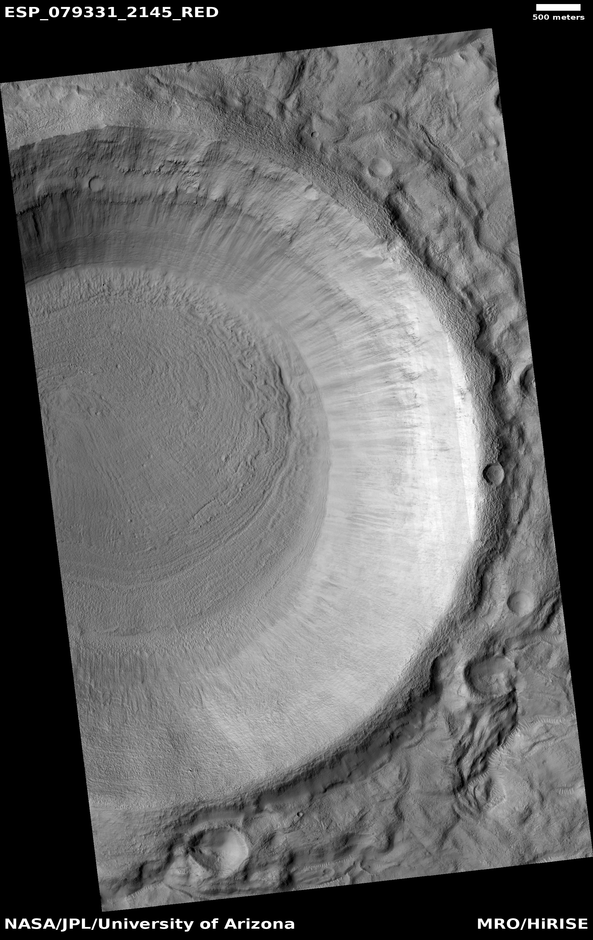
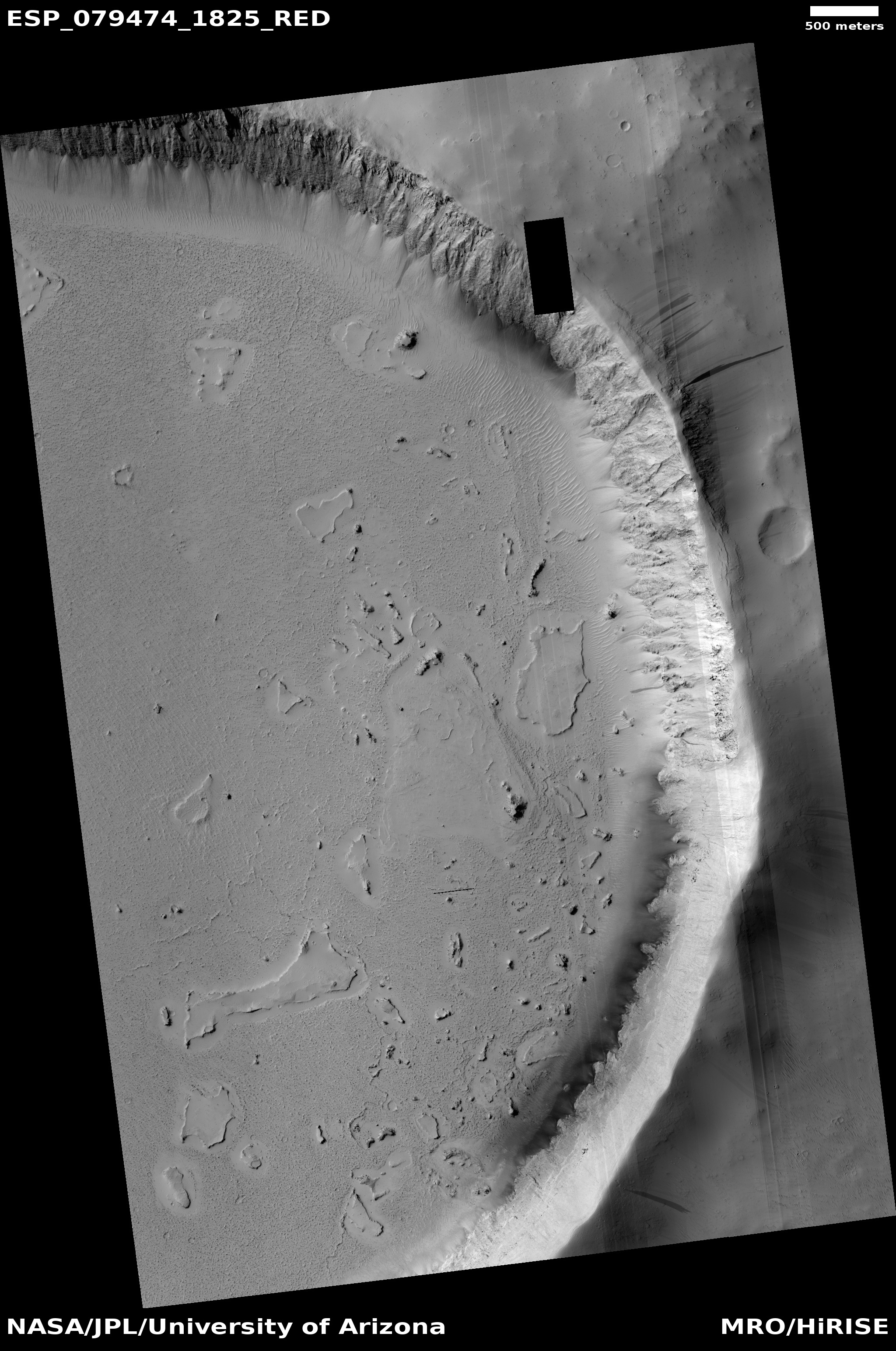
Badlands on the floor of a Martian crater

Badlands on the floor of a Martian crater
Click for full image.

Cool image time! The photo to the right, rotated, cropped, and reduced to post here, shows one small section of a 30-mile-wide unnamed crater in the cratered equatorial regions of Mars northeast of Hellas Basin. Taken on July 21, 2021 by the high resolution camera on Mars Reconnaissance Orbiter (MRO), the science team labeled merely as “Rocky crater fill.”

Being at 17 degrees south latitude, there shouldn’t be any ice features in this crater, and the high resolution image to the right seems to confirm this. All we see is an endless plain made up of innumerable small sharp rock ridges interspersed with small low areas filled with sand dunes. This is bed rock, and if its strange stucco-like appearance was caused by a past glacial era, that era is long gone.

Below is a mosaic showing the entire crater, created from two MRO context camera images.
» Read more

Lozenge-shaped hole in Martian crater

Hole in crater floor
Click for full image.

Cool image time! The photo to the right, rotated, cropped, reduced, and enhanced to post here, was taken on June 7, 2021 by the high resolution camera on Mars Reconnaissance Orbiter (MRO).

The left image shows what the scientists have dubbed a “lozenge-shaped depression” in the middle of an unnamed 60-mile-wide crater in the southern cratered highlands of Mars. The right image shows the same exact depression, but I have brightened the photo in order to see the details in the shadowed depression.

Though the image is inconclusive, the bottom of the darkest spot in that depression cannot be seen, suggesting it could be an entrance into a larger void below.

Even if there is no voids below, why is this depression here? What caused it? The wider view of MRO’s context camera below might give us a hint.
» Read more

An example why scientists think there were catastrophic floods on Mars

Broken mesas on Mars
Click for full image.

Today’s cool image provides a nice illustration why scientists have long assumed that in the distance past there had been catastrophic floods of liquid water on Mars. The photo to the right, rotated, cropped, and reduced to post here, was taken on July 6, 2021 by the high resolution camera on Mars Reconnaissance Orbiter (MRO). It shows an east-west gully cutting between mesas to the north and south.

Because the highest mesas seem to be aligned, this suggests they were once part of the same formation, and something came along to carve that gap and gully between them.

What made the break? The overview map below as usual provides some context, which also provides a possible explanation.
» Read more

Data from Opportunity suggests surface dew periodically appears even in the dry equatorial regions

Using data from the rover Opportunity, scientists now think that the renewal of Martian salt crusts on rock surfaces on the rim of Endeavour Crater could possibly by caused by the appearance of rare thin wetting events, and that such events could have even occurred very recently and be on-going..

The scientists looked at the rate of erosion and renewal of the salt crusts, and found them to be in a steady state. The erosion is slow, taking from 200,000 to 2,000,000 years to remove 1 to 2 millimeters. However, periodically a thin film of water or wetting occurs, not unlike dew on Earth, which quickly acts to renew the crust. As David Mittlefehldt of the Astromaterials Research Office at the Johnson Space Center and the lead author of the paper explained to me,

Taken together, the data leaves open the possibility the salt mobilization has occurred within the last few thousand years. It could be ongoing in the sense that over a period of thousands? or hundreds? of years it might happen again.

In other words, the evidence suggests that every few hundred or thousand years the surface of these rocks gets wet, which results in the placement of a new thin layer of salt crusts.

Mittlefehldt also emphasized to me that these wetting events are rare, and “there is also the case that such an event may never come again because of changing conditions.”

The situation is essentially like on Earth, where in some places hydrologists measure the size of floods by how rare they are. A 1,000 year flood is big, but it happens very rarely. At Endeavour Crater these wetting events are comparably rare, but they do not involve big floods, but a mere moistening of the ground.

The location of Endeavour Crater is about 2 degrees south latitude, so it sits in the dry equatorial regions where no surface or near surface ice has so far been found. However, the cyclic nature of Mars’ orbit and obliquity could have changed this in the past, and could change this again in the future. At this time we simply don’t have enough information to know.

On the edge of Mars’ glacier country

Color dry mesas on Mars
Click for full image.

Today’s cool image sits right on the southern edge of Mars’ northern glacier country, at 29 degrees north latitude. The picture to the right, cropped and reduced to post here, was taken of this location on June 4, 2021 by the high resolution camera on Mars Reconnaissance Orbiter (MRO). It shows what appears to be the exposed and scraped bedrock and mesas on the floor of an unnamed 60-mile-wide crater.

That scraped bedrock is quite beautiful, reminiscent of the bare carved mesas and bedrock one sees throughout the southwest of the United States. To hike from that central valley to the top of the bright mesa would be a fine experience, especially because of the suggested change in colors in the color strip.

The overview map below gives more context.
» Read more

Glaciers and mesas on Mars

Overview map

Cool image time! Today we return to glacier country on Mars, that band of mensae mesas and glaciers that stretches more than 2,000 miles in the northern mid-latitudes, as shown on the overview map above.

No rovers or landers have yet visited this region, nor are any planned. To the west just beyond the map’s left edge is the planned landing site of Europe’s Franklin rover. To the east and south and just beyond the map’s right edge is where America’s Perseverance rover presently travels in Jezero Crater.

Our journey today begins from afar, and will steadily zoom into the area of the red cross and a most intriguing feature seen in a recent picture taken by the high resolution camera on Mars Reconnaissance Orbiter (MRO).

Before we look at that high resolution image, it is better to view the area using MRO’s context camera, as what it shows helps make sense of the features in the close-up.
» Read more

Perseverance’s 2nd drill attempt to get sample appears successful

It appears that Perseverance’s second drill attempt on Mars has successfully obtained sample material in its core.

Data received late Sept. 1 from NASA’s Perseverance rover indicate the team has achieved its goal of successfully coring a Mars rock. The initial images downlinked after the historic event show an intact sample present in the tube after coring. However, additional images taken after the arm completed sample acquisition were inconclusive due to poor sunlight conditions. Another round of images with better lighting will be taken before the sample processing continues.

Once they know for sure if they have a sample, they will store it and then move on, heading to the area that Ingenuity scouted for them in mid-August.

Posted halfway to Las Vegas.

A peanut-shaped crater in the northern plains of Mars

Context camera image of peanut-shaped crater
Click for full image.

Cool image time! The photo to the right, rotated, cropped and reduced to post here, was taken in May 2008 by the wide angle context camera on Mars Reconnaissance Orbiter (MRO). It shows what the scientists have since labeled a “peanut-shaped crater.”

What caused this unusual shape? The obvious and most likely explanation is that this was a double impact that occurred simultaneously. Imagine the ground being hit either by an asteroid with two lobes or by two similar-sized asteroids falling side-by-side.

Fast forward thirteen years to 2021. In the fifteen years since 2006 when MRO begin science operations in orbit around Mars no high resolution images were taken of this crater. Finally, on July 30, 2021, scientists finally decided to take a high resolution image of this crater’s western half. You can see that image below, rotated, cropped, and reduced to post here.
» Read more

Stucco on Mars!

Stucco on Mars
Click for full image.

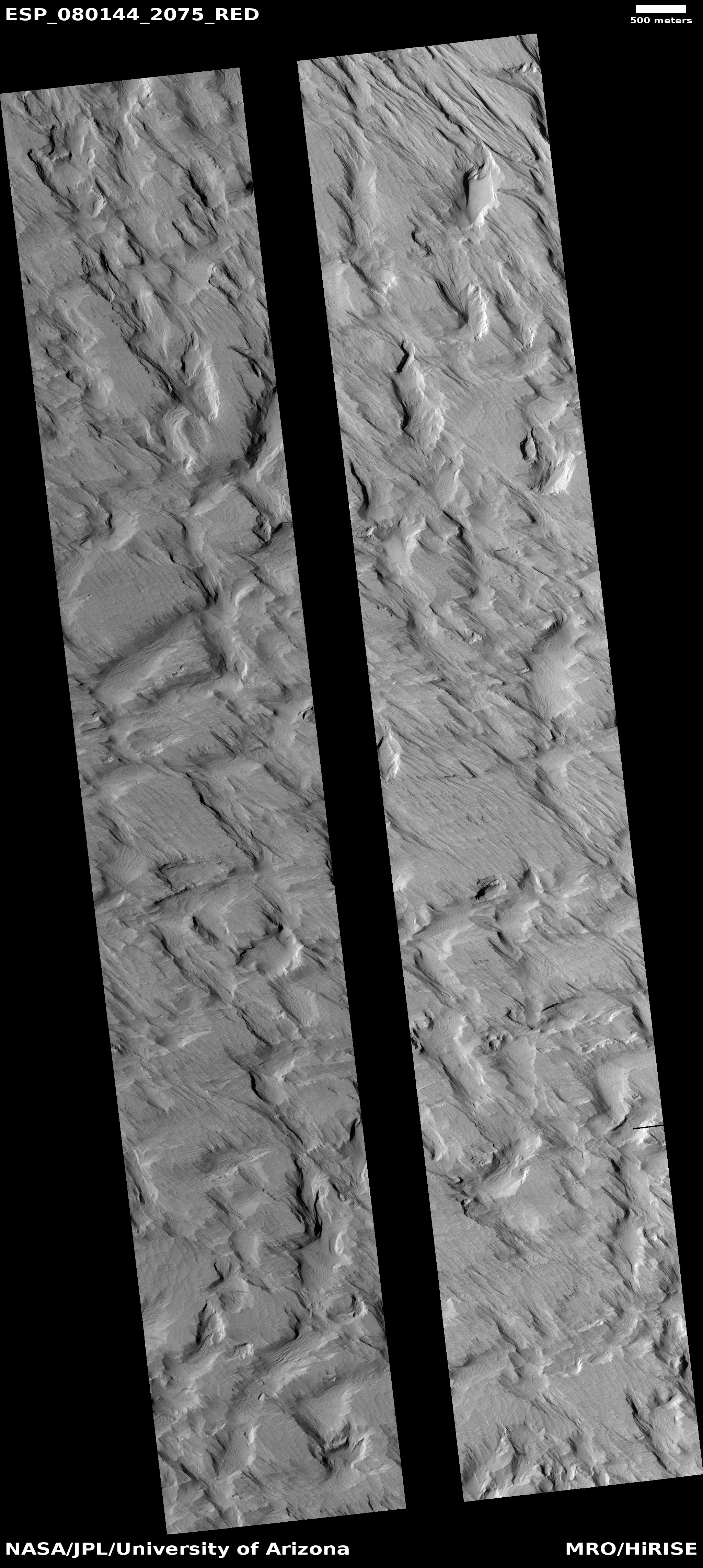
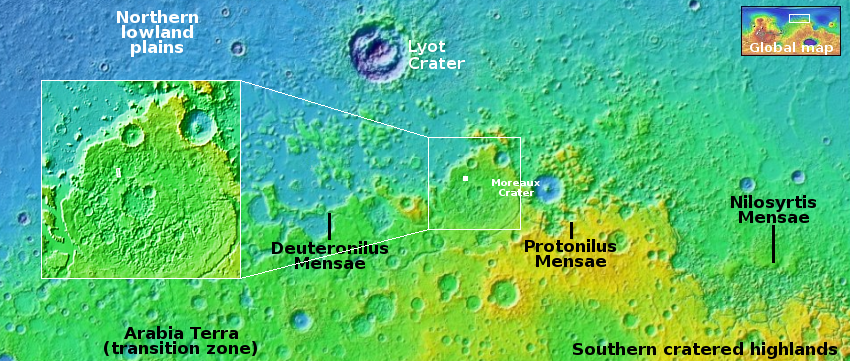
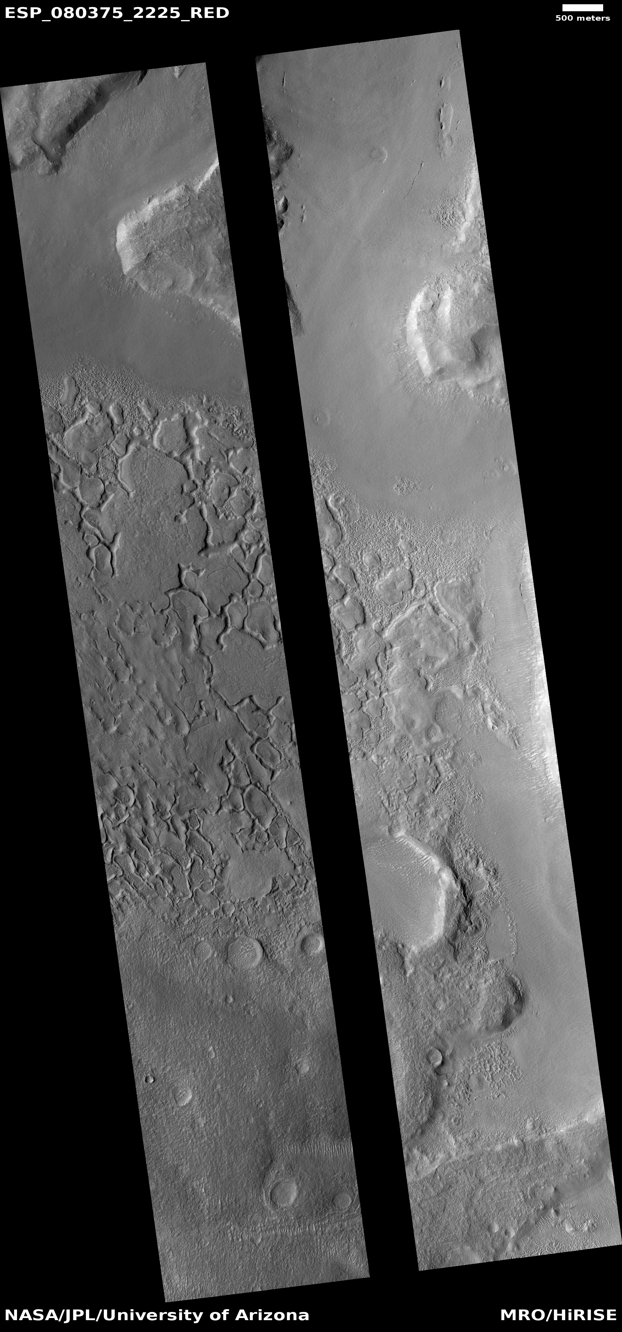
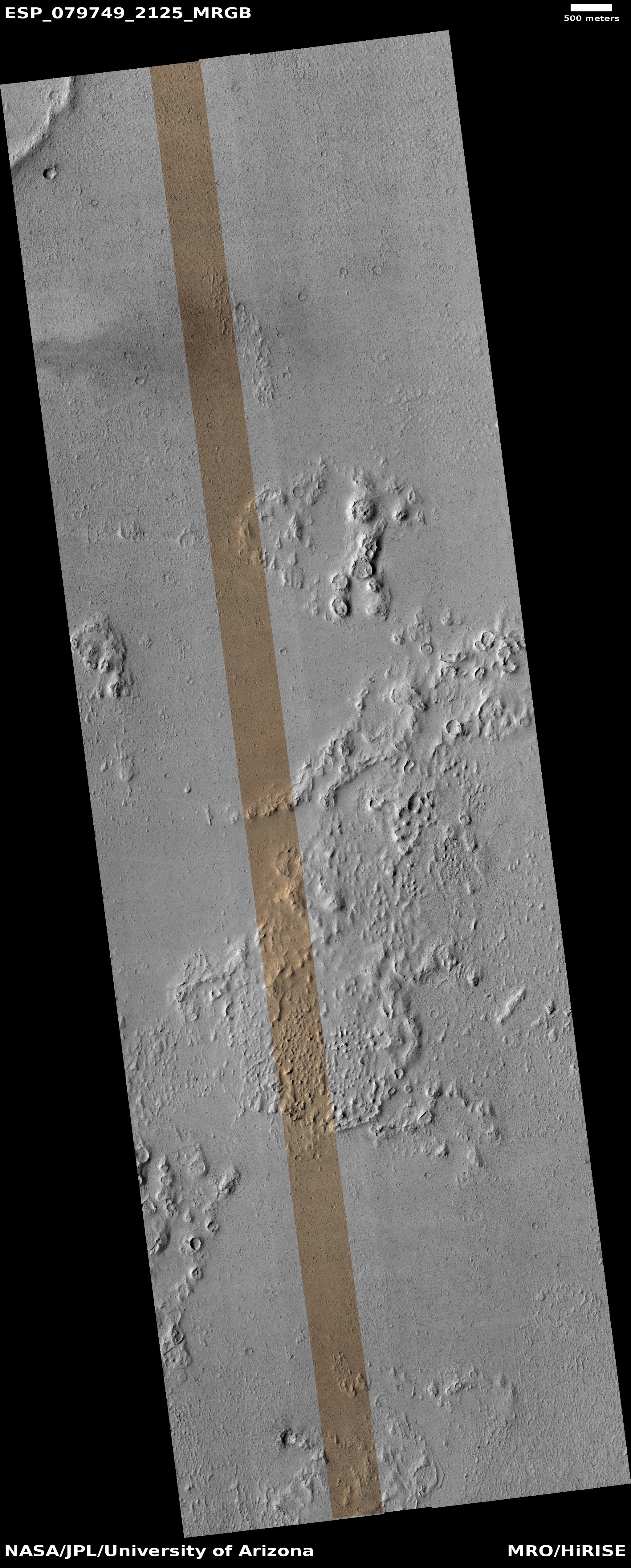
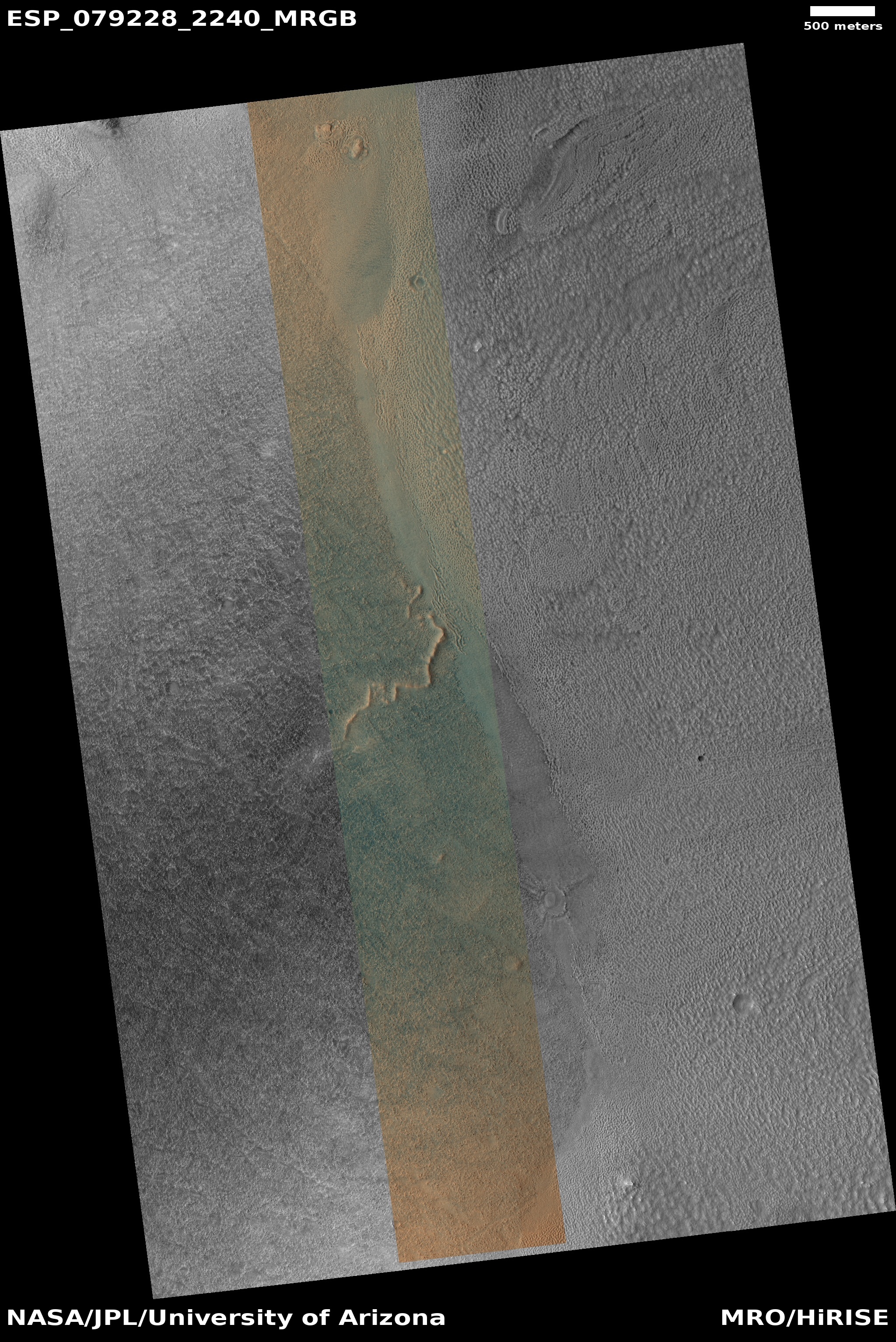
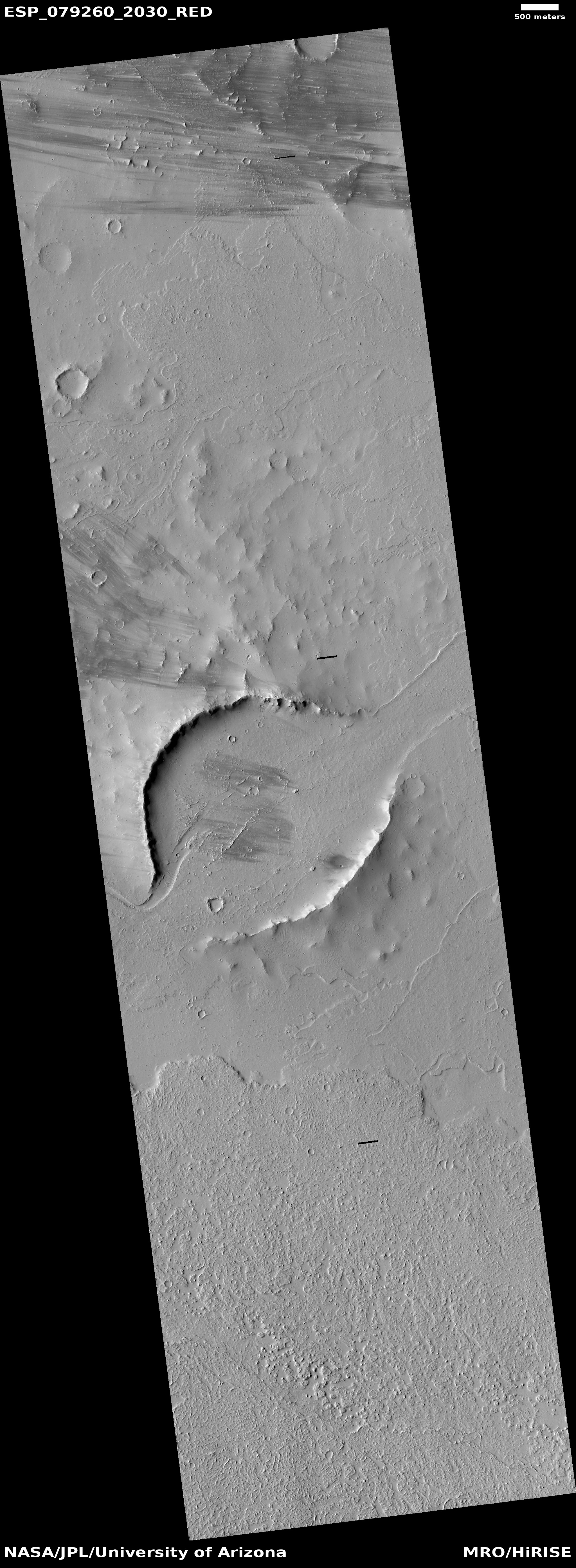
Cool image time! The picture to the right, cropped to post here, was taken on June 8, 2021 by the high resolution camera on Mars Reconnaissance Orbiter (MRO). It shows a strangely flat plain with a complex stucco-type surface of ridges and depressions. The sunlight is coming from the west, which makes the smoother flat areas depressions.

What are we looking at? What causes this strange surface? Make sure you look at the full image, because the section I cropped out doesn’t give a true sense of the terrain’s vastness.

The MRO science team labeled the photo “volcanic terrain,” but that tells only part of the story, since this volcanic terrain is actually part of Mars’ most interesting lava plains, as the overview map below shows.
» Read more

An ancient curving channel on Mars

Context image of curving channels
Click for full image.

Cool image time! The photo to the right, rotated, cropped, and reduced to post here, was taken by the wide angle context camera on Mars Reconnaissance Orbiter (MRO) in April 2019. It shows an area on Mars where a number of meandering curving channels flow downhill from the west to the east.

Earlier MRO images had already spotted these channels, so when this context image was taken the scientists also took a high resolution image of the same channels, with the white box indicating the area covered by the rotated, cropped, and reduced image below.

Both images are today’s MRO image of the day, where the MRO team notes that “The objective of this observation is to examine a complex network of channels. Some parts of the channels are quite curved.”
» Read more

New cracks across old Martian lava flows

New cracks across an old lava flow
Click for full image.

Cool image time! The photo to the right, cropped and reduced to post here, was taken on June 4, 2021 by the high resolution camera on Mars Reconnaissance Orbiter (MRO). It captures one of the many deep straight fissure canyons that make up the feature dubbed Cerberus Fossae in the center of Mars’ volcano country.

The crack is called a graben, and happens when the ground is either stretched from pressure from below, or when two adjacent large blocks of material move sideways relative to each other.

What makes this particular graben interesting are two features. First, the overlapping break suggests something complex took place at this spot when the crack separated. Second, the crack cut across the foot of an older frozen lava flow, meaning it has to be younger than that flow.

The overview map below provides a clue when that lava flow might have occurred, while also suggesting this crack in Cerberus Fossae might be much younger than expected.
» Read more

A weak avalanche season on Mars?

The north pole scarp
Click for full image.

Today’s cool image from Mars is cool both for what is visible in the photo and for what is not, the latter of which might turn out to be a discovery of importance.

The photo to the right, cropped and reduced to post here, was taken on June 24, 2021 by the high resolution camera on Mars Reconnaissance Orbiter (MRO). It shows a section of the edge of Mars’ north polar ice cap, with north at the top.

This scarp is probably more than 2,000 feet high, though that height drops to the south as the upper layers disappear one by one from either long term erosion or sublimation. Those layers represent the visible information in the photo that is cool. They give us tantalizing clues about the geological and climatic history of Mars. Each layer probably represents a climate period when the north icecap was growing because the tilt of the planet’s rotation was even less than the 25 degrees it is now. When that tilt is small, as small as 11 degrees, the poles of Mars are very cold, and water ice migrates from the mid-latitudes to the poles, adding thickness to the icecaps. When the tilt grows, to as much as 55 degrees, the mid-latitudes are colder than the poles, and the water ice migrates back to the mid-latitudes.

What is not visible in this picture, however, might be far more significant.
» Read more

A dry bedrock Martian crater floor?

A dry bedrock crater floor?
Click for full image.

Cool image time! The photo to the right, cropped and reduced to post here, was taken on June 21, 2021 by the high resolution camera on Mars Reconnaissance Orbiter (MRO). The location is a very eroded crater at about 26 degrees north latitude. The image shows the crater’s crater floor, with a variety of bedrock-type features, sharp ridges, abrupt scarps, and flat smooth plateaus, with a hint of lobate glacial flows in the image’s southeast quadrant.

At 26 north latitude, it is unlikely that anything here is icy, unless it is very well protected by debris. Most of these features are almost certainly bedrock, though their formation could very well have been shaped by ice in past eons when this location was more amenable to water ice.

The wider MRO context camera image of the entire crater, plus the overview map, give a larger picture, and raise some interesting questions.
» Read more

Lacy patterns in the high north of Mars

lacy patterns in the high north of Mars

Cool image time! The photo to the right, cropped, reduced, and rotated so that north is up, was taken on May 12, 2021 by the high resolution camera on Mars Reconnaissance Orbiter (MRO). It shows the strange lacy patterns seen routinely in the very high northern latitudes surrounding the Martian north pole.

Located in a region of the vast northern lowland plains dubbed Scandia Tholi, such features are apparently common here. From a 2011 geology paper of the region’s geological history:

We find that Scandia Tholi display concentric ridges, rugged peaks, irregular depressions, and moats that suggest uplift and tilting of layered plains material by diapirs and extrusion, erosion, and deflation of viscous, sedimentary slurries as previously suggested. These appear to be long-lived features that both pre-date and post-date impact craters.

The small circular feature near the bottom of the picture appears to be a mesa, and might be a pedestal crater, so old that the surrounding terrain has worn away and left the hardened-by-impact crater as a butte. To its right is a larger circular mesa with its scarp well eroded into hollows. This might also be a pedestal crater, or not.

The white lacy patterns could be frost, either water ice or dry ice. That the white lace tends to favor the north-facing slopes lends support to this guess. The photo was taken in the early spring, so the thin mantle of carbon dioxide that falls to cover the polar region south to sixty degrees latitude is only beginning to sublimate away.

A Martian river of ice

Glacial flow on Mars?
Click for full image.

Cool image time! The photo to the right, rotated, cropped and reduced to post here, was taken on May 13, 2021 by the high resolution camea on Mars Reconnaissance Orbiter (MRO). It spans the entire 4.7 mile width of the southern hemisphere canyon dubbed Reull Vallis. The white arrow indicates the direction of the downhill grade

The scientists title this image “Lineated Valley Fill.” The vagueness of this title is because they have not yet confirmed that this lineated valley fill is a glacier flowing downhill to the west.

Nonetheless, the material filling this valley has all the features one expects glaciers to exhibit. Not only is the the lineation aligned with the flow, it varies across the width of the canyon as glaciers normally do. At the edge the parallel grooves are depressed, probably because they are torn apart by the canyon walls as the glacier flows past. In turn, at the center of the flow the grooves are thinner and more tightly packed, and appear less disturbed. Here, the flow is smooth, less bothered by surrounding features.

This pattern also suggests the merging of two flows somewhere upstream.

A glance at the spectacular Concordia glacier in the Himalayas near the world’s second highest mountain, K2, illustrates the similarity of this Martian feature to Earth glaciers.

Reull Vallis itself flows down to Hellas Basin, the deepest basin on Mars. As it meanders downhill along its 650 mile length it steadily gets wider and less distinct as it drops into Hellas. Along its entire length MRO has photographed numerous similar examples of this lineated fill, all suggesting that under a thin layer of debris is a thick glacier, slowerly carving this canyon out.

The overview map below illustrates these facts nicely, while further reinforcing these glacial conclusions.
» Read more

A chain of Martian sinkholes

Chain of sinkholes on Mars
Click for full image.

Cool image time! The photo to the right, rotated, cropped, and reduced to post here, was taken on June 17, 2021 by the high resolution camera on Mars Reconnaissance Orbiter (MRO). It shows a somewhat straight depression with several wider and deeper pits along it.

The feature immediately suggests sinkholes that exist because the ground is sagging into voids below ground. Yet, both the straight and circular depressions also appear filled, showing no evidence that they connect to any below ground cavities.

Are the sinks the result of a fissure produced by a graben, when two large blocks shift relative to each other to cause a fissure to appear? Or are they evidence of an underground lava tube? Or maybe they are the filled remains of a now mostly buried canyon carved by water or ice?

As always, a wider view helps clarify things, though whether it answers the question is uncertain.
» Read more

Glacial ice sheets on Mars?

Glacial ice sheets on Mars?
Click for full image.

Cool image time! The photo to the right, rotated, cropped, and reduced to post here, was taken on June 29, 2021 by the high resolution camera on Mars Reconnaissance Orbiter (MRO). The location is in Mars’ glacier country, that strip of chaos terrain that runs about 2,000 miles along the transition zone between the northern lowland plains and the southern cratered highlands at 30 to 47 degrees north latitude. This particular feature is located in Deuteronilus Mensae, the westernmost region of that strip of chaos.

I call this glacier country because practically every image taken by MRO’s high resolution camera in this region suggests the presence of glacial material covered by a protective layer of debris. The photo to the right is typical, though a bit more puzzling because of the depressions that appear to run along highpoints.

As usual, the overview map below helps explain what we are looking at.
» Read more

Peeling thin layers on a Martian plateau

Peeling thin layers on Mars
Click for full image.

Cool image time! The photo to the right, cropped to post here, was taken on May 14, 2021 by the high resolution camera on Mars Reconnaissance Orbiter (MRO). It shows what the science team labels as “light-toned layered deposits.”

Their focus, rightly from a geologist’s perspective, is the contrast in color between different layers, suggesting different composition and thus a different formation history for each layer.

To me, what made this feature appealing is the thinness and number of its layers. It reminded me of fillo pastry, “unleavened flour dough formed into very thin sheets or leaves.”

If you look at the full image you will see that cropped section only covers one edge of a tongue-shaped plateau, with similar layers revealed along its entire cliff wall. It is almost like those layers have been peeling off for eons to leave the plateau behind.

The location below gives some context.
» Read more

White blobs on Mars

White blobs on Mars
Click for full image.

Time for another “What the heck?” image. The photo to the right, cropped to post here, was taken on May 18, 2021 by the high resolution camera on Mars Reconnaissance Orbiter (MRO). It shows what appears to be a series of white circular features aligned with a ridge line.

Are these eroded craters? Maybe, but their alignment with those ridges suggests otherwise. If you look at the full image, you will see further parallel ridges to the north and south, also with similar circular blobs lined along them. Furthermore, the flat surrounding terrain, part of the northern lowland plains north of the resurgences from Valles Marineris, has a scattering of very normal looking craters, with distinct rims and even some glacial material within. As this is at 44 degrees north latitude, the presence of glacial material inside craters is not surprising.

Thus, the white blobs are likely not craters, but some form of eruptive material from below, coming up along those ridges which are probably faultlines. The whiteness suggests that material is water ice, but this of course is unconfirmed.

The question is of course, why? What would cause water ice to erupt along these faultlines? And why are such features not seen elsewhere? Faults and underground ice are common on Mars. Yet, I don’t remember seeing features such as this in any other Martian images.

Martian lava flooded crater?

lava flooded crater?
Click for full image.

A quick cool image! The photo to the right, rotated, cropped and reduced to post here, was taken by the high resolution camera on Mars Reconnaissance Orbiter (MRO) more than a decade ago, on June 1, 2010. I post it now because it is today’s MRO picture of the day, and is definitely cool. The caption:

One of a few “scaly-looking” inselbergs within regional platy-ridged flows in Elysium Planitia. This inselberg has a broken and blocky appearance with some of the blocks being tilted. Could this be the remnant of a once extensive mantling deposit? An inselberg is an isolated hill or mountain rising abruptly from a plain.

The wider image by MRO’s context camera below, also rotated, cropped and reduced to post here, illustrates even more forcefully how isolated this circular set of blocks is.
» Read more

The sublimating surface of Mars’ northern plains?

Sublimating patches on Mars?
Click for full image.

Cool image time! The photograph to the right, cropped and reduced to post here, was taken by the high resolution camera on Mars Reconnaissance Orbiter on May 27, 2021. A sample image, likely taken not as part of any specific scientist’s research but by the camera team in order to maintain the camera’s temperature, shows an area of the Martian northern plains that appears filled with rough scattered depressions, possibly caused by sublimation of buried ice.

The location, at 54 degrees north latitude, is far enough north to easily have a lot of buried ice. It is also only about 40 miles to the east of Milankovič Crater, where scientists have found many scarps that appear to have exposed layers of ice in their cliff faces.

However, the location has other components that must raise questions about this sublimating ice hypothesis.
» Read more

The nearest hill to China’s Zhurong

Pitted cone near Zhurong
Click for full image.

Cool image time! The science team for the high resolution camera on Mars Reconnaissance Orbiter (MRO) today released a pair of images the camera took on June 28, 2021 of the nearest pitted cone to China’s Zhurong rover.

The stereo anaglyph to the right, cropped and reduced to post here, allows you, with blue-red 3D glasses, to see the cone in three dimensions. Quite impressive. As noted by Alfred McEwen of the Lunar & Planetary Laboratory in Arizona in his caption,

This image completed a stereo pair of a region just west of where the Zhurong rover landed in southern Utopia Planitia.

The cutout is from a portion of the stereo anaglyph, showing an enigmatic pitted cone. Is this cone composed of sediments or volcanic materials? The sharp bright features surrounding the cone are aeolian (wind-blown) landforms.

According to McEwan, the hill itself is about 200 to 220 feet high, with the pit at its top about 60-65 feet deep.

While McEwan has told me this cone would be his primary target if he was running Zhurong, it appears the Chinese are instead heading south toward the largest nearby crater, and on the way inspecting the parachute, fairing, and heat shield discarded just prior to landing.

The mosaic below from three MRO context camera images provides a wider overview.
» Read more

Fractured crater close to the Phoenix lander on Mars

Fractured crater on Mars
Click for full image.

Cool image time! The photo to the right, cropped to post here, was taken on May 3, 2021 by the high resolution camera on Mars Reconnaissance Orbiter (MRO). It shows a remarkably fractured crater that lies only a few miles to the southeast of where the now-inactive Phoenix lander put down back in 2008, at the very high latitude of 69 degrees north.

Phoenix was purposely sent to this high latitude to find out what the ground and atmosphere was like there. It found the following:

Phoenix’s preliminary science accomplishments advance the goal of studying whether the Martian arctic environment has ever been favorable for microbes. Additional findings include documenting a mildly alkaline soil environment unlike any found by earlier Mars missions; finding small concentrations of salts that could be nutrients for life; discovering perchlorate salt, which has implications for ice and soil properties; and finding calcium carbonate, a marker of effects of liquid water.

Phoenix findings also support the goal of learning the history of water on Mars. These findings include excavating soil above the ice table, revealing at least two distinct types of ice deposits; observing snow descending from clouds; providing a mission-long weather record, with data on temperature, pressure, humidity and wind; observations of haze, clouds, frost and whirlwinds; and coordinating with NASA’s Mars Reconnaissance Orbiter to perform simultaneous ground and orbital observations of Martian weather.

Below is an overview map showing the location of both this crater and the Phoenix lander.
» Read more

Ice, lava, quakes, and faults, all in one Martian image

A lot of geology in one picture
Click for full image.

Cool image time! The photo to the right, rotated, cropped, and reduced to post here, was taken by the high resolution camera on Mars Reconnaissance Orbiter (MRO) on April 25, 2021. It grabbed my attention because it possibly captures a whole range of Martian geological processes, all in one place, including evidence of quakes, of lava, of faults, and possibly of glaciers.

First, ignore the black rectangle, which is merely a small section of lost data.

The picture itself shows a wide north-south fissure, as indicated by the distinct western cliff and the fainter and less pronounced eastern cliff. This fissure, likely formed along a fault, was created when the crust was pushed and stretched upward by the pressure of underground volcanic magma, part of the long series of eruptions that formed the many similar and parallel north-south fissures south of the shield volcano Alba Mons.

The overview map below illustrates this fissure’s relationship with Alba Mons.
» Read more

The wind-swept volcanic ash plains of Mars

Overview map

Cool image time! In Mars’ volcano country lies the planet’s largest ash deposit, dubbed the Medusae Fossae Formation. Scientists believe that this gigantic deposit, with a size comparable to the nation of India, was laid down by muliple volcanic eruptions over several billion years and is the source of most of the dust seen on the Red Planet.

The overview map on the right shows the location of this ash deposit on Mars. The white cross indicates the location of today’s cool image, found below.
» Read more

Another “What the heck?” photo from Mars

Isolated clump of mounds on Mars
Click for full image.

The cool image to the right, cropped and reduced to post here, was taken a decade ago, on August 25, 2011, by the context camera on Mars Reconnaissance Orbiter (MRO), It shows a flat plain with a sudden clump of mounds or hills at the center.

This is one of those pictures from Mars which I like to call a “What the heck?” image. What caused the mounds, and why are they found only in this concentrated clump, with the rest of the terrain around them generally flat?

Though the context image was taken a decade ago, no follow-up high resolution images were taken of this area until very recently.

Below is the one recent high resolution image taken by MRO on May 12, 2021, cropped and reduced to show the bottom half of the mound clump as shown by the white box. It makes the mystery even more puzzling.
» Read more

Ice-filled craters in Mars’ glacier country?

Craters in Protonilus Mensae
Click for full image.

Today’s cool image returns us to the chaos region dubbed Protonilus Mensae, the middle of three adjacent mensae regions in the northern hemisphere that I like to dub Mars’ glacier country because there is so much evidence of buried ice there.

The photo to the right, cropped to post here, was taken on May 31, 2021 by the high resolution camera of Mars Reconnaissance Orbiter (MRO). Titled “Layered Feature in Crater in Protonilus Mensae,” the section I have posted focuses on several craters, with the one with the central mesa likely the picture’s target. Based on many similar features found in craters in this region, it is somewhat safe to assume that this mesa is made of buried ice.

The overview map below as always provides the context.
» Read more

Cracks, chaos, and maybe caves in one place on Mars

Mosaic of Avernus Cavi fissures
Click for higher resolution. Original images found here and here.

Today’s cool image to the right is a mosaic I have made from two images taken by the context camera on Mars Reconnaissance Orbiter (MRO), showing a most intriguing region on Mars dubbed Avernus Cavi, located in the large volcanic plain called Elysium Planitia between the giant volcanoes Elysium Mons and Olympus Mons, a region I like to call Mars’ volcano country.

The mosaic shows in one picture much of the typical terrain in Avernus Cavi. We see many linear depressions or cracks, created when the ground stretched and cracked at weak points. We also see many depressions that suggest sinkholes, places where the surface sagged down because of a void below ground.

The area of knobs and mesas in the picture’s southeast quadrant is very typical Martian chaos terrain, the later result of long term erosion of these cracks and depressions.

The white box shows the area covered by the image below.
» Read more

First attempts to map the layered geology of Mars

layers in Jiji Crater on Mars
Click for full image.

Today’s cool image illustrates well the central task of much of today’s geological research on Mars, using the orbital images to try to map out the visible geological layers seen, and figure out if those layers mark over wide regions specific geological epochs, as they do on Earth.

The photo to the right, cropped and reduced to post here, was taken on May 4, 2021 by the high resolution camera on Mars Reconnaissance Orbiter (MRO), and featured on July 12th as a captioned image entitled “Layers Blanket a Crater Floor.” From the caption:

This image shows a layered rock formation within Jiji Crater that has eroded into buttes and stair-like layers.

This formation extends west and east. Similar layered rocks are within several craters in Arabia Terra and Meridiani Planum, including [nearby] Sera and Banes craters. The similarities suggest that the same process was forming deposits over a large geographic area long ago. Our image also indicates that much of the formation has eroded away relative to what has remained.

As you can see in the photo, the layers form a neat staircase of terraces descending from the south crater rim to the crater floor. They suggest that once the crater was filled with this material, which over time eroded away.

An image of similar layered buttes and mesas in Sera crater, only about 20 miles away, was featured here on Behind the Black in December 2020 The overview map below shows the relationship between Jiji, Sera, and Banes craters.
» Read more

New images from Zhurong on Mars

Zhurong's view north
Click for full image.

China today released three new images from its Zhurong Mars rover, showing that since their last release in late June the rover has traveled about 1,000 feet to the south to reach the parachute and backshell (or entry capsule), both released just before landing.

The image to the right, cropped and reduced to post here, is the color panorama from that release, looking north. According to a translation of the Chinese press release, provided at this Space.com report, the image shows:

“The complete back cover structure after aerodynamic ablation, the attitude control engine diversion hole on the back cover is clearly identifiable,”

Below is an annotated orbital picture of this location taken by Mars Reconnaissance Orbiter (MRO) in mid-June.
» Read more

1 13 14 15 16 17 29