Click for original image.
The Webb Space Telescope has taken its first infrared image of Supernova SN1987A, the closest supernova to Earth in five centuries at a distance of 168,000 light years away in the nearby Large Magellanic Cloud.
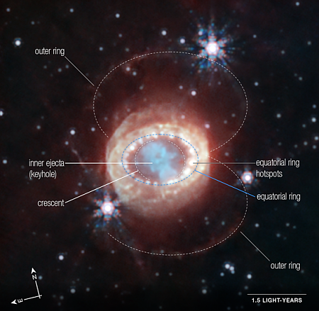
The annotated image to the right, cropped, reduced, and sharpened to post here, shows that supernova remnant as Webb sees it. Most of the structures identified here have been observed now for decades as the material from the explosion has been expanding outward. However,
While these structures have been observed to varying degrees
by NASA’s Hubble and Spitzer Space Telescopes and Chandra X-ray Observatory, the unparalleled sensitivity and spatial resolution of Webb revealed a new feature in this supernova remnant – small crescent-like structures. These crescents are thought to be a part of the outer layers of gas shot out from the supernova explosion. Their brightness may be an indication of limb brightening, an optical phenomenon that results from viewing the expanding material in three dimensions. In other words, our viewing angle makes it appear that there is more material in these two crescents than there actually may be. [emphasis mine]
I highlight that one word because it is unnecessary, and is only inserted to punch up Webb’s abilities for public relations purposes. Moreover, the rest of the text of the full press release at the link is even worse. It provides little information about the evolution of this supernova since its discovery more than three decades ago, but instead waxes poetic again and again about how wonderful Webb is.
Though Webb certainly has much higher resolution than the earlier infrared space telescope Spitzer and can do far more, this tendency of NASA press releases to use these superlatives only devalues Webb. The images themselves sell the telescope. No need to oversell it in the text.
Meanwhile, the significance of SN 1987A is not explained. Since the development of the telescope by Galileo in the early 1600s, there has been no supernova inside the Milky Way. SN 1987A has been the closest, so it has been photographed repeatedly in multiple wavelengths to track the evolution of the explosion’s ejecta. Webb now gives us a better look in the infrared, though in truth the small amount of new details is actually somewhat disappointing.