An inactive volcanic vent on Mars

An inactive volcanic vent on Mars
Click for full image.

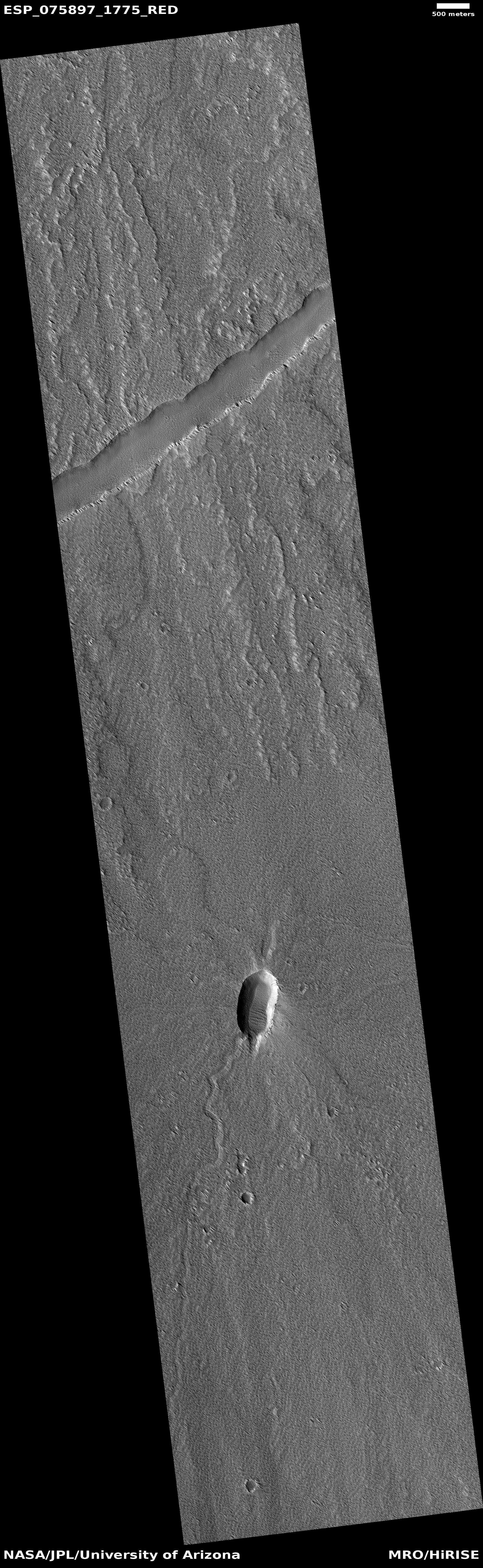
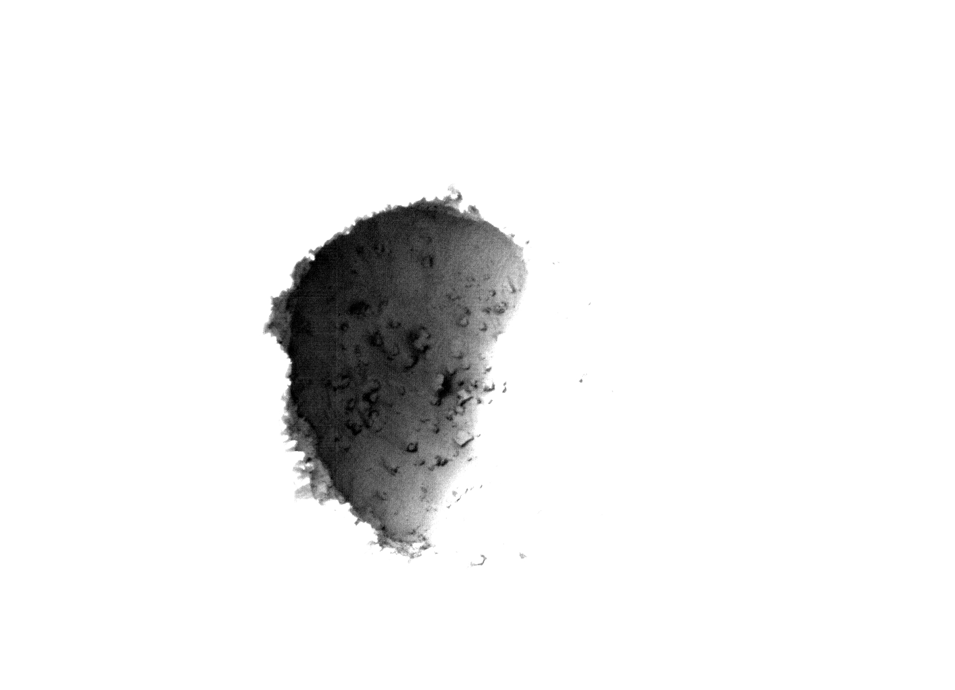
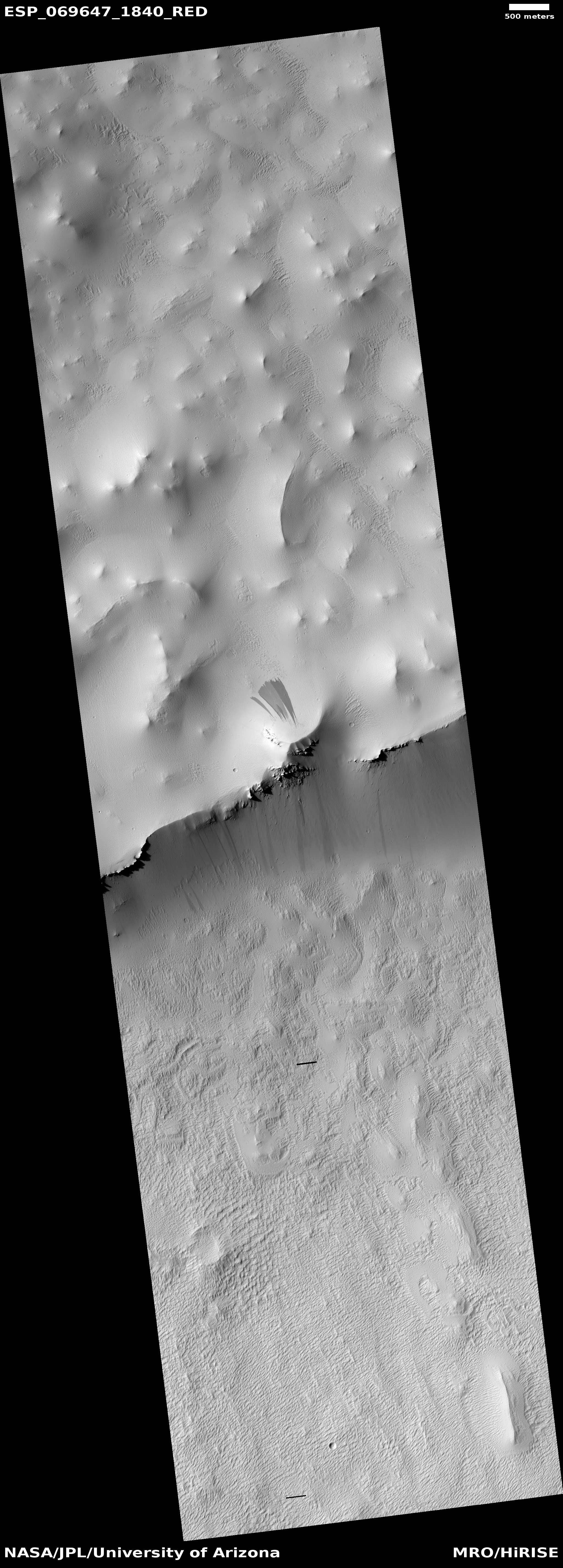
Cool image time! The picture to the right, rotated, cropped, and reduced to post here, was taken on October 5, 2022 by the high resolution camera on Mars Reconnaissance Orbiter (MRO). Labeled by the science team as “Vents and Lava Flows on Flank of Pavonis Mons,” the section to the right shows the picture’s largest vent. The downhill grade is to the south.

In the full photo you can see that this vent sits on top of a flat mound of hardened lava, all of which flowed from the vent in the distant past. The main flow of course went to the south, out the channel and down the flanks of Pavonis Mons, the middle volcano in the line of three just to the west of Mars’ giant Valles Marineris canyon. The caldera peak of Pavonis Mons is about 35 miles away, and sits at a height of 47,000 feet elevation, far higher than Mount Everest but still only the fourth highest Martian volcano.

In the full picture, the entire surface also generally flows south, except for a crack that goes from northeast to southwest, possibly caused when the mountain flank sagged to the south.
» Read more

Slope streaks in frozen lava flows on Mars

Slope streaks on frozen lava
Click for full image.

Cool image time! The photo to the right, cropped and reduced to post here, was taken on June 5, 2021 by the high resolution camera on Mars Reconnaissance Orbiter (MRO). It shows a ridgeline at the base of the giant volcano Pavonis Mons, with slope streaks on ridge’s north and south sides.

Slope streaks are a mysterious phenomenon unique to Mars. While they resemble an avalanche, they do not change the topography of the surface at all. They appear to occur randomly year round, fading slowly with time. Also, while most are dark, scientists have also spotted bright slope streaks as well.

Slope streaks also only appear on surfaces covered with a layer of fine dust, something that is obviously the case in the cool image to the right. There is so much dust on the surface here that bedrock only appears at the top of the ridge, peeking out in only a few places.

The location of this image, as shown in the overview map below, adds some additional details.
» Read more

A lonely dry lava spring on Mars

A lonely dry lava spring on Mars
Click for full image.

Today’s cool image from Mars takes us to the southern flank of the giant volcano Pavonis Mons. The photo to the right, rotated, cropped, and reduced to post here, shows what appears to be a volcanic vent from more than a billion years ago when it is believed Pavonis was actively erupting. The picture was taken on March 2, 2021 by the high resolution camera on Mars Reconnaissance Orbiter (MRO). The grade is mostly downhill to the east and south east.

It is very possible that this is the resurgence of a lava tube, the point where the underground flow either emerged to the surface or got so close to the surface that the ceiling was thin enough to later collapse, creating this depression. No pits or skylights are visible in this high resolution picture, however, so whether there is an underground lava tube here is not known, an unknown that is amplified by the wider MRO context camera image below.
» Read more

Two pits at opposite ends of Mars’ big volcanoes

Overview map

Regular readers of Behind the Black know that since 2018 I have regularly documented all the images of pits taken by the high resolution camera on Mars Reconnaissance Orbiter (MRO). (See my last pit post in January for a full list of these previous articles.) The black dots on the map to the right shows the location of all the pits near the volcanoes Arsia and Pavonis Mons that have so far been highlighted here.

The two white dots are the two most recent MRO pits, and are the subject of today’s cool image. They also happen to be the farthest north and south pits so far documented. The southernmost pit, which I am saving till last, is the most interesting.
» Read more

Martian impact into lava crust?

Impact crater north of Pavonis Mons
Click for full image.

Cool image time! The photo on the right, cropped to post here, was taken by the high resolution camera on April 23, 2019. It shows a quite intriguing impact crater on the northern lava slopes of Pavonis Mons, the middle volcano in the chain of three gigantic volcanoes to the west of Valles Marineris.

What makes this image cool is what the impact did when it hit. Note the circular depression just outside the crater’s rim. In the southeast quadrant that ring also includes a number of additional parallel and concentric depressions. Beyond the depression ground appears mottled, almost like splashed mud.

What could have caused this circular depression? Our first clue comes from the crater’s location, as shown in the overview map below and to the right.
» Read more

Taking a look back at a Martian pit

Pavonis Mons pit
Click for full image.

The pit to the right could almost be considered the first “cool image” on Behind the Black. It was first posted on June 20, 2011. Though I had already posted a number of very interesting images, this appears to be the first that I specifically labeled as “cool.”

The image, taken by the high resolution camera on Mars Reconnaissance Orbiter (MRO), had been requested by a seventh grade Mars student team at Evergreen Middle School in Cottonwood, California, and shows a pit on the southeastern flank of the volcano Pavonis Mons, the middle volcano in Mars’ well-known chain of three giant volcanoes. A close look at the shadowed area with the exposure cranked up suggests that this pit does not open up into a more extensive lava tube.

What inspired me to repost this image today was the release of a new image from Mars Odyssey of this pit and the surrounding terrain, taken on July 31, 2019 and shown below to the right.
» Read more

Volcanic vent between Arsia and Pavonis Monsa

volcanic vent on Mars

Cool image time. The photo on the right, rotated, cropped, and reduced to post here, was taken in September by the high resolution camera of Mars Reconnaissance Orbiter (MRO) and was part of the November image release. Click on the image to see the entire photograph at full resolution.

The uncaptioned release dubs this feature as “Small Eruptive Vents South of Pavonis Mons.” In truth, these vent pits are located almost exactly the same distance from both Pavonis Mons, the middle volcano in the line of three giant Martian volcanoes, and Arsia Mons, the southernmost of the three.

The image is interesting for several reasons. First, note the bulge surrounding the vent, making this look almost like a miniature volcano all its own. In fact, that is probably what it is. When it was active that bulge was likely caused by that activity, though it is hard to say whether the bulge was caused by flow coming from out of the vent, or by pressure from below pushing upward to cause the ground to rise. It could even have been a combination of both.

To my eye, most of the bulge was probably caused from pressure from below pushing upward. The edge of the bulge does not look like the leading edge of a lava flow. Still, this probably happened so long ago that Martian wind erosion and dust could have obscured that leading edge.

That this is old is indicated by the dunelike ripples inside the large pit, and the pond of trapped dust in the smaller pit. Because of the thinness of the Martian atmosphere it takes time to gather that much dust, during which time no eruptions have occurred.

One more interesting detail: If you look at the pits in full resolution, you will see that, based on the asymmetrical wind patterns between the west and east rims, the prevailing winds here are from the west. Located as it is just to the east of the gigantic saddle between Arsia and Pavonis Mons, this wind orientation makes sense, as a saddle between mountains tends to concentrate the wind, much like a narrowed section in a river produces faster water flow and rapids. As for why the wind blows mostly from the west, my guess (which should not be taken very seriously) is that it is probably caused by the same meteorological phenomenon that causes this generally on Earth, the planet’s rotation.

Volcanic rills and lava tubes on Mars

Rills and lava tubes on Pavonis Mons

Cool image time! The image on the right, cropped somewhat to show here, was taken by Mars Odyssey of the southwestern slope of Pavonis Mons, the middle volcano of the line of three giant volcanoes located between the biggest volcano in the solar system, Olympus Mons, and the biggest canyon in the solar system, Marineris Valles. The slope goes down to the south, from the top to the bottom of the image. As noted on the image page,

The channel and nearby oval depressions are both related to the flow of lava. Narrow lava flows can create channels. The cooling of the top of the channel will form a roof over the flow, creating a tube beneath the surface. After the lava stops flowing the tube can empty, leaving a subsurface void. The roof will then collapse into the void forming the oval surface features.

I have added arrows to the image to draw your eye to the features that extend south in line with those oval depressions, eventually widening out to resemble a river delta, with the obvious rill probably indicating the lowest point in that delta.

Though the oval depressions are likely sections of a lava tube that collapsed, the features in line with those depressions suggest that the tube itself might still exist below the surface to the south, feeding into that delta where the rill meanders. It is also possible that my desire to find underground voids here, where glacier ice might possibly exist, might be skewing my conclusion. It could also be that the lava tube ended at these depressions, and what the features indicate is a wide surface flow, later embellished by the smaller flow of the meandering rill.

Martian craters go splat!

Overview of the volcanic Tharsis Bulge on Mars

Cool image time! In continuing my exploration of this month’s Mars Reconnaissance Orbiter (MRO) image release, I found two interesting images of small craters, one as part of that image release, the other found completely by accident.

The map on the right, taken from the MRO HiRISE archive page, shows the locations of these two images. Both are located in the lava plains that surround the giant volcano Pavonis Mons, the central volcano of the three volcanoes to the east of Olympus Mons. Previously, I have done posts focusing specifically on both Pavonis Mons and Arsia Mons. Not only is the geology of these gigantic volcanoes fascinating, there is evidence that ancient glacial ice lurks in lava tubes on their slopes, making them potentially prime real estate for future explorers.

The first image, labeled #1 on the image above, was taken in January 2018 to get a better look at a small crater on the surrounding lava plains, and was part of the MRO March image release. I have cropped it to post here, focusing on the crater itself.

My first reaction on seeing the image was, “Did this impact not go splat when it hit?”
» Read more

Exploring one of Mars’ giant volcanoes

Master index

For the past two weeks JPL’s image site has been releasing a string of images taken by Mars Odyssey of the smallest of Mars’ four giant volcanoes.

Pavonis Mons is one of the three aligned Tharsis Volcanoes. The four Tharsis volcanoes are Ascreaus Mons, Pavonis Mons, Arsia Mons, and Olympus Mars. All four are shield type volcanoes. Shield volcanoes are formed by lava flows originating near or at the summit, building up layers upon layers of lava. The Hawaiian islands on Earth are shield volcanoes. The three aligned volcanoes are located along a topographic rise in the Tharsis region. Along this trend there are increased tectonic features and additional lava flows. Pavonis Mons is the smallest of the four volcanoes, rising 14km above the mean Mars surface level with a width of 375km. It has a complex summit caldera, with the smallest caldera deeper than the larger caldera. Like most shield volcanoes the surface has a low profile. In the case of Pavonis Mons the average slope is only 4 degrees.

The image on the right is the context image, annotated by me to show where all these images were taken. The images can accessed individually below.

Each of these images has some interesting geological features, such as collapses, lava tubes, faults, and flow features. Meanwhile, the central calderas are remarkable smooth, with only a few craters indicating their relatively young age.

The most fascinating geological fact gleaned from these images is that they reveal a larger geological trend that runs through all of the three aligned giant volcanoes to the east of Olympus Mons.

The linear and sinuous features mark the locations of lava tubes and graben that occur on both sides of the volcano along a regional trend that passes thru Pavonis Mons, Ascreaus Mons (to the north), and Arsia Mons (to the south).

This trend probably also indicates the fundamental geology that caused all three volcanoes to align as they have.

Arsia Mons is of particular interest in that water clouds form periodically above its western slope, where there is also evidence of past glaciation. Scientists strongly suspect that there is a lot of water ice trapped underground here, possibly inside the many lava tubes that meander down its slopes. These facts also suggest that this might be one of the first places humans go to live, when they finally go to live on Mars.