Webb launch delayed four days because of “incident” during stacking

NASA management has decided to delay the launch of the James Webb Space Telescope for four days while engineers investigate whether an “incident” that occurred during the telescope’s stacking on top of an Ariane 5 rocket could have long term consequences.

Technicians were preparing to attach Webb to the launch vehicle adapter, which is used to integrate the observatory with the upper stage of the Ariane 5 rocket. A sudden, unplanned release of a clamp band – which secures Webb to the launch vehicle adapter – caused a vibration throughout the observatory.

A NASA-led anomaly review board was immediately convened to investigate and instituted additional testing to determine with certainty the incident did not damage any components. NASA and its mission partners will provide an update when the testing is completed at the end of this week.

The launch had been scheduled for December 18th. They have now pushed it back to December 22nd.

11 comments

Video of Ingenuity’s 13th flight

Using the high resolution camera on Perseverance, the science team has now released two videos taken of Ingenuity’s 13th flight on Mars, on September 4, 2021.

One is a very wide view, which makes it hard to see the helicopter. The closer view can be seen here.

At the beginning of the video, Ingenuity is near the lower left of frame, at a distance of about 980 feet (300 meters) from the rover. It climbs to an altitude of to 26 feet (8 meters) before beginning its sideways translation. The helicopter leaves the camera’s field of view on the right. Soon after, the helicopter returns into the field of view (the majority of frames that did not capture helicopter after it exited the camera’s field of view were purposely not downlinked from Mars by the team) and lands at a location near its takeoff point.

1 comment

Lucy update: Instruments all working, no action yet on solar array

According to an update from the Lucy science team today, they have completed the checkout of the asteroid probe’s instruments, and found them all operating properly. However, no action has yet been taken to try to correct the partially deployed solar panel.

The team has used an engineering model of the solar array motor and lanyard to replicate what was observed during the initial solar array deployment. The test data and findings suggest the lanyard may not have wound on the spool as intended. Testing continues to determine what caused this outcome, and a range of scenarios are possible. The team isn’t planning to attempt to move or further characterize the current state of the solar array deployment before Wednesday, Dec. 1, at the earliest.

It appears the spacecraft is still on its planned course.

1 comment

Hubble’s 2021 survey of the outer solar system

Jupiter in 2021 by Hubble
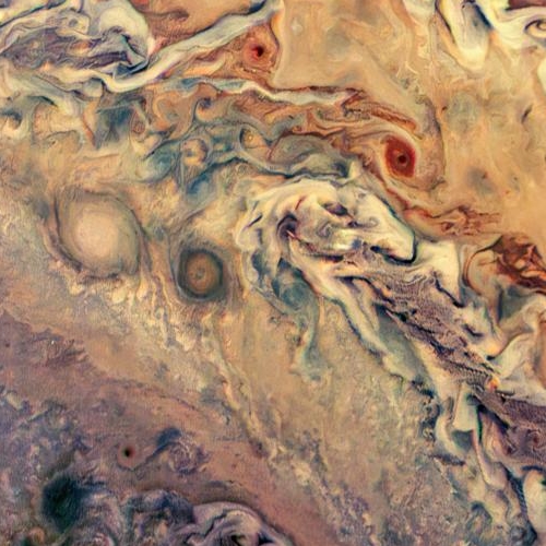
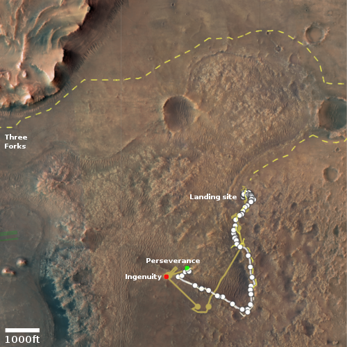
Click for full Jupiter image.

Saturn in 2021 by Hubble
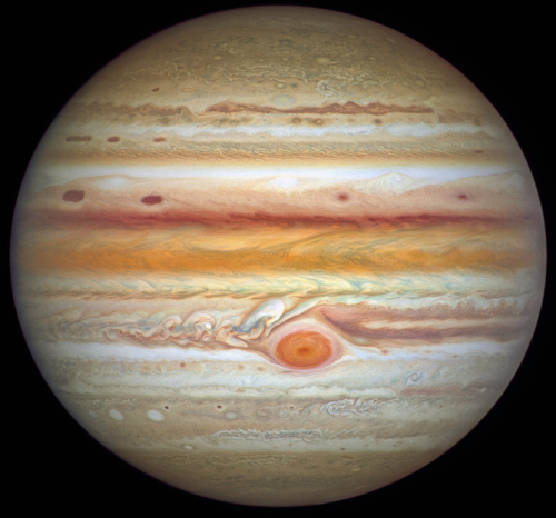
Click for full Saturn image.

Uranus in 2021 by Hubble
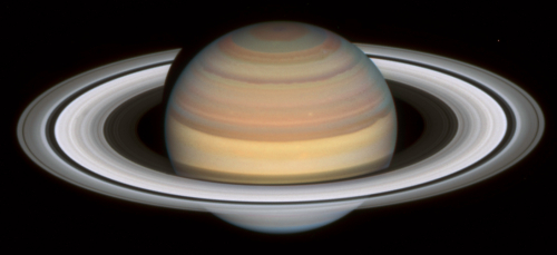
Click for full Uranus image.

Neptune in 2021 by Hubble
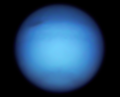
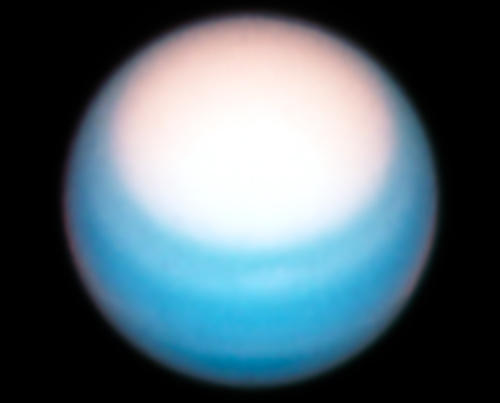
Click for full Neptune image.

NASA today released the annual survey of images taken each year by the Hubble Space Telescope of the large planets that comprise the outer solar system, Jupiter, Saturn, Uranus, and Neptune.

These Hubble images are part of yearly maps of each planet taken as part of the Outer Planets Atmospheres Legacy program, or OPAL. The program provides annual, global views of the outer planets to look for changes in their storms, winds, and clouds. Hubble’s longevity, and unique vantage point, has given astronomers a unique chance to check in on the outer planets on a yearly basis. Knowledge from the OPAL program can also be extended far beyond our own solar system in the study of atmospheres of planets that orbit stars other than our Sun.

The four photos, all either cropped or reduced slightly to post here, are to the right. Each shows some changes in these planets since the previous survey images the year before.

On Jupiter for example the equatorial region shows several new storms, with that band remaining a deep orange color longer than expected.

On Saturn the various bands have continued to show the frequent and extreme color changes that the telescope has detected since it began these survey images back in the 1990s.

The photo of Uranus meanwhile looks at the gas giant’s northern polar regions, where it is presently spring. The increased sunlight and ultraviolet radiation has thus caused the upper atmosphere at the pole to brighten. The photo also confirms that the size of this bright “polar hood” continues to remain the same, never extending beyond the 43 degree latitude where scientists suspect a jet streams acts to constrain it.

The image of Neptune, the farthest and thus hardest planet for Hubble to see, found that the dark spot in the planet’s northern hemisphere appears to have stopped moving south and now appears to be heading north. Also,

In 2021, there are few bright clouds on Neptune, and its distinct blue with a singular large dark spot is very reminiscent of what Voyager 2 saw in 1989.

2 comments

Europe’s Solar Orbiter to make last flyby of Earth

Solar Orbiter, the European Space Agency’s (ESA) probe to work in tandem with NASA Parker Solar Probe in studying the inner regions surrounding the Sun, will make last flyby of Earth on November 27, 2021, thus putting it into its planned science orbit.

While the press release gives a good overview of the mission, it focuses on the risk during that fly-by of the spacecraft hitting something during its close approach.

Solar Orbiter’s Earth flyby takes place on 27 November. At 04:30 GMT (05:30 CET) on that day, the spacecraft will be at its closest approach, just 460 km above North Africa and the Canary Islands. This is almost as close as the orbit of the International Space Station.

The manoeuvre is essential to decrease the energy of the spacecraft and line it up for its next close pass of the Sun but it comes with a risk. The spacecraft must pass through two orbital regions, each of which is populated with space debris.

The first is the geostationary ring of satellites at 36 000 km, and the second is the collection of low Earth orbits at around 400 km. As a result, there is a small risk of a collision. Solar Orbiter’s operations team are monitoring the situation very closely and will alter the spacecraft’s trajectory if it appears to be in any danger.

While there is a risk, it seems to me that ESA is taking advantage of the recent news outburst in connection with the Russian anti-sat test and the space junk it created to sell this mission. The risk of impact during this fly-by is very low, especially in the geostationary ring.

0 comments

NASA awards Intuitive Machines another contract to deliver science instruments to Moon

Capitalism in space: NASA yesterday awarded Intuitive Machines its third contract to use its Nova-C lander to deliver four science instruments in 2024 to an unusual geological feature on the Moon.

The investigations aboard Intuitive Machines’ Nova-C lander are destined for Reiner Gamma, one of the most distinctive and enigmatic natural features on the Moon. Known as a lunar swirl, Reiner Gamma is on the western edge of the Moon, as seen from Earth, and is one of the most visible lunar swirls. Scientists continue to learn what lunar swirls are, how they form, and their relationship to the Moon’s magnetic field.

…Intuitive Machines will receive $77.5 million for the contract and is responsible for end-to-end delivery services, including payload integration, delivery from Earth to the surface of the Moon, and payload operations. This is Intuitive Machines’ third task order award, the first of which is a delivery to Oceanus Procellarum on the Moon during the first quarter of 2022. This award is the seventh surface delivery task award issued to a CLPS partner.

Below is the present schedule for these commercial unmanned lunar landers:

  • 2022: Astrobotic to deliver 11 instruments to the crater Lacus Mortis.
  • 2022: Intuitive Machines to deliver 6 payloads to Oceanus Procellarum.
  • 2022: Intuitive Machines to deliver a drill and two instruments to the lunar south pole.
  • 2023: Firefly to deliver 10 instruments to Mare Crisium.
  • 2023: Masten to deliver nine instruments to the lunar south pole region.
  • 2023: Astrobotic to deliver VIPER rover to lunar south pole region.
  • 2024: Intuitive Machines to deliver 4 payloads to Reiner Gamma.

No one should be surprised if some of these landers fail. The goal of this program is to jumpstart a commercial industry of private lunar landers, which is why NASA is awarding so many contracts. Some will fail. Some will succeed. In the end both NASA and the general public will have several competing options for landing payloads on the Moon.

0 comments

Volcanic vent on Mars

Overview of Arsia Mons pits

To understand today’s cool image we really should start from a distance and zoom in. The overview map to the right focuses in on the two southernmost giant volcanoes in the string of three that sit to the east of Mars’ biggest volcano, Olympus Mons, and to the west of the planet’s biggest canyon, Valles Marineris.

The black dots mark the locations of the many high resolution photos taken by Mars Reconnaissance Orbiter that I have featured previously on Behind the Black. Many are isolated openings with no related geological features. Others appear to be skylights into a more extensive lava tube, hinted at by either a continuing surface depression or a series of similar skylights.

The white dot marks the location of today’s cool image, about 350 miles south of Arsia Mons’ caldera.
» Read more

2 comments

UAE Al-Amal Mars orbiter finds surprising variations in Mars atmosphere

Oxygen variations in Martian atmosphere
Click for full graphic.

The United Arab Emirates Al-Amal (“hope” in English) Mars orbiter has discovered unexpected variations of oxygen and carbon monoxide in the Martian atmosphere.

The EMM team had expected to observe a relatively uniform emission from oxygen at 130.4 nm across the planet and yet here we are, faced with unpredicted variations of 50% or more in the brightness.

The image to the right, cropped and reduced to post here, shows the variations in oxygen on Mars’s dayside. Though the map does not indicate the geography below, the concentration of oxygen in the northern latitudes appears to correspond to the planet’s northern lowland plains. In fact, the variations should not have been a surprise, since the surface of Mars has such a stark dichotomy between its northern and southern hemispheres.

0 comments

Craters in the soft Martian northern lowland plains

Craters in the soft Martian northern lowland plains
Click for full image.

Cool image time! The photo to the right, cropped and reduced to post here, was a featured image today from the high resolution camera on Mars Reconnaissance Orbiter (MRO).

The caption, written by Carol Weitz of the Planetary Science Institute in Arizona, focused on the wind patterns created within these craters.

These impact craters in the northern middle latitudes have interesting interiors: all of them have wind-blown (aeolian) ripples.

Outside of the craters and along the crater floors, the ripples are all oriented in the same direction. However, along the walls of some of the larger craters, the ripples are situated radially away from the center, indicating the winds moving inside the larger craters can be influenced by the topography of the crater wall.

Additionally, many of the larger craters have layered mesas along their floors that are likely sedimentary deposits laid down after the craters formed but prior to the development of the aeolian ripples.

I am further intrigued by the rimless nature of these craters, as well as the lack of significant rocky debris at their edges. They all look like the bolides that created them impacted into a relatively soft surface that, rather than break up into rocks and boulders, melted, flowed, and then quickly refroze into these depressions.

The location, as always, provides us a possible explanation.
» Read more

2 comments

Zhurong’s continuing travels on Mars

Zhurong overview map
Click for original map.

This past week the Chinese press released a new but limited update on the status of both its Mars orbiter Tianwen-1 and its Mars rover Zhurong.

The map to the right uses as its background a high resolution picture from Mars Reconnaissance Orbiter. I have superimposed Zhurong’s route in green. You can get an idea of how far the rover has traveled since resuming communications with Earth in late October by comparing this map with the one I posted then. After stopping at a small sand dune (the crescent-shaped white features), it curved around to head to the southeast towards a rough area and a trough that is thought to be filled with sediment.

Meanwhile, the orbiter has shifted its orbit, changing from one dedicated mainly as providing a communications relay between Zhurong and Earth to one that now allows it to begin a two-year photographic survey of Mars.

To supplement the resulting gaps in communications for Zhurong, China and the European Space Agency (ESA) have made their first test using ESA’s Mars Express satellite as a relay satellite. Both hope to know soon whether it worked.

In either case, Zhurong’s travels will likely be slowed somewhat due to the reduction in communications access.

0 comments

Snow on Martian dunes

Snowy dunes near the Martian north pole
Click for full image.

Close-up of snowy dunes
Click for full image.

Cool image time! The first photo to the right, rotated, cropped, and reduced to post here, was taken on September 19, 2021 by the high resolution camera on Mars Reconnaissance Orbiter (MRO), and shows what appears to be snow nestled in the hollows of many dunes.

The second photo, cropped to post here, shows in high resolution the area in the white box.

Is that snow water, or dry ice? The location is very far north, 76 degrees latitude, so it could be either. Since the photo was requested by Candice Hansen of the Planetary Science Institute in Arizona, I emailed her to ask. Her answer:

Early in the spring all the bright stuff is dry ice. As it gets later in the spring it is probably still mostly dry ice but with HiRISE images alone we cannot really distinguish the composition of the ice. In-between the dunes it is almost certainly bare ground late in the spring, but since the dunes are dark the surface just looks bright in contrast

This picture was taken in summer, which suggests the snow is probably water, not dry ice. Yet, all the snow is found in the north-facing hollows, places that will remain mostly in shadow at this high latitude, 76 degrees north. Thus, it is possible that the snow is the last remaining traces of the thin dry ice mantle that covers the Martian poles down to about 60 degrees latitude during the winter, and sublimates away in summer.

Hansen had requested a whole bunch of similar images of such snowy dunes. As she explained,
» Read more

2 comments

Scientists: Asteroid in an orbit entwined with the Earth might be Moon rock

Data obtained by scientists using ground-based telescopes now suggests that the small asteroid Kamo`oalewa, which has an orbit that makes it a quasi-Moon of the Earth, might have originally come from the Moon.

From their paper’s abstract:

We find that (469219) Kamoʻoalewa rotates with a period of 28.3 (+1.8/−1.3) minutes and displays a reddened reflectance spectrum from 0.4–2.2 microns. This spectrum is indicative of a silicate-based composition, but with reddening beyond what is typically seen amongst asteroids in the inner solar system. We compare the spectrum to those of several material analogs and conclude that the best match is with lunar-like silicates. This interpretation implies extensive space weathering and raises the prospect that Kamo’oalewa could comprise lunar material.

Kam’oalewa — which is only about 150 feet across — is one of five such quasi-Earth-moons. All orbit the Sun in orbits that are similar to the Earth’s and are such that the asteroids periodically loop around our planet each year.

This data will be useful to the Chinese, who are planning a mission to Kamo-oalewa in ’24 to grab samples.

0 comments

The stormy atmosphere of Jupiter

Jupiter's South South Temperate Belt
Click for full image.

Cool image time! The photo to the right, cropped to post here, was created by citizen scientist Thomas Thomopoulo from a Juno image taken during its 16th close pass of Jupiter in 2018. To bring out the different colors of the clouds he enhanced the resolution and color contrast.

We have no scale, but I would guess the distances seen exceed several thousand miles. The area covered is what is called Jupiter’s South South Temperate Belt, the visible belt at about 40 degrees south latitude that circles the South Polar Region (which is the darker purple swirls in the bottom left). This belt is difficult to observe from Earth because of its high latitude, with the curve of Jupiter’s limb beginning to bend away from view.

1 comment

A volcanic extrusion on the floor of Valles Marineris?

A volcanic extrusion on the floor of Valles Marineris?
Click for full image.

Cool image time! The photo to the right, rotated, cropped, and reduced to post here, was taken on August 31, 2021 by the high resolution camera on Mars Reconnaissance Orbiter (MRO). It shows what the science team labels a “possible contact between two units.”

I think that contact is the point where that eroded mountain touches the surrounding smooth canyon floor. The mountain itself looks to me to be a very eroded extrusion of lava that was placed there from below a very very long time ago, covered later by material, and now exposed for a long enough period that its surface appears to have been carved by wind and even possibly flowing water or ice.

Because it is lava it is more resistant to erosion, which is why it sits higher than the smooth terrain around it. Even though both experienced the same processes of wear over time, the mountain’s surface was only carved away partly, while the material that had been in the floor was washed away entirely.

This is all a guess. However, a look below at the overview map, showing this mountain’s location on Mars, as well as MRO’s wider view from its context camera, I think strengthens my hypothesis.
» Read more

0 comments

Lucy’s solar panel problem could be due to strap

According to the engineering team for the Lucy asteroid mission, they now think the incomplete deployment of one of the probe’s solar panels was caused by a strap.

The joint Anomaly Response Team has been studying the array using an engineering model. Initial tests indicate that the lanyard that pulls out the solar array may not have completed the process successfully; however, it is still uncertain what caused this condition. The team is conducting more tests to determine if this is indeed the case, and what the root cause might be.

An attempt to characterize the array deployment by attempting to move it would occur no earlier than Nov. 16.

Meanwhile, they have been turning on Lucy’s instruments one by one, with everything functioning as planned, except for that one solar panel. The panel however is a serious concern, as the spacecraft is heading out to the orbit of Jupiter, where it will need every inch of solar panel surface area to get enough power to operate. At the moment it appears the panel is deployed somewhere between 75% to 95%.

5 comments

Hubble camera back in operation

Good news! As engineers work to fix the problem that caused the Hubble Space Telescope to shut down on October 25th, they have now successfully returned Hubble’s most important camera back to doing science.

The Hubble team successfully recovered the Advanced Camera for Surveys instrument Nov. 7. The instrument has started taking science observations once again. Hubble’s other instruments remain in safe mode while NASA continues investigating the lost synchronization messages first detected Oct. 23. The camera was selected as the first instrument to recover as it faces the fewest complications should a lost message occur.

This success strongly suggests they have pinpointed the software issue that caused the shutdown, and can now step-by-step reactivate all the other instruments in the coming week.

0 comments

Frozen lake bed in the Martian high latitudes?

Frozen lakebed in the Martian high latitudes?
Click for full image.

Today’s cool image comes from today’s Mars Reconnaissance Orbiter’s (MRO) high resolution picture of the day, rotated and cropped to post here. The original was taken back on March 28, 2017.

What formed those strange circular ridges and the many small cracks and hollows? The caption provided is somewhat vague and I think confusing:

This formation looks like a crater from a meteor impact rather than an ancient caldera of a volcano. Connected to the crater is a carved-out area that resembles a lake bed. At high resolution, we might be able to determine the likelihood of a water lake bed or lava bed. This observation will give insight into some of the interesting geology of this area.

The crater this caption is referring to is not visible in the image provided. It can be seen to the west of this location, in the MRO context camera picture below.
» Read more

0 comments

Curiosity: Approaching the saddle

The saddle ahead
Click for full image.

Cool image time! The photo to the right, reduced to post here, was taken on November 5, 2021 by Curiosity’s high resolution camera, and looks forward at its planned route up onto the saddle ahead, where the rover will turn right and climb up into Maria Gordon Notch. (See this October post for a map outlining the rover’s future travels.) I think that cliff face is between 40 to 60 feet high, though this is a very wild guess.

As noted by Abigail Fraeman of JPL on the Curiosity blog on November 3, 2021,

The terrain is beginning to steepen as Curiosity gets close to the end of this region, so even though we’re only a few drives away from our last drill site … we’ve already climbed 25 m higher!

The route ahead looks equally steep, though the ground actually appears less rough, with fewer large jagged boulders that Curiosity must avoid to protect its wheels.

It will likely be at least one to three weeks however before Curiosity gets to that saddle. The science team has begun a drilling campaign at the present location, and this will take time, depending on how many holes they decide to drill.

1 comment

Ingenuity completes 15th flight

Ingenuity landing on November 6th
Click for full image.

No details have been released, but based on the latest raw images downloaded from the Mars rover Perseverance today, the helicopter Ingenuity successfully completed its 15th flight in Jezero Crater yesterday.

The image to the right is the last of five released this morning, showing the helicopter’s shadow on the ground, just before Ingenuity touched down. Note how the shadow of Ingenuity’s four legs appear oriented level relative to the ground. While the first of the five images shows the shadow tilted, as if the helicopter is making a last turn, the last four photos all show the legs oriented properly.

We will have to wait now for official confirmation.

7 comments

Ingenuity next flight will begin route retracing its path

Overview map

The Ingenuity engineering team has revealed that the helicopter’s 15th flight on Mars will have it begin retracing its steps, following approximately the same flight route as it heads back towards Perseverance’s landing site in Jezero Crater.

Flight #15 is the start of our journey back to Wright Brothers Field [the helicopter’s initial flight test area just north of the landing site]. Taking place no earlier than Saturday, Nov. 6 at 9:22 a.m. PT, or 12:03 LMST (local Mars time), the 254th sol (Martian day) of the Perseverance mission, Flight #15 will return Ingenuity back to the Raised Ridges region, imaged in Flight #10. In this flight the helicopter will traverse 1,332 feet (406 meters) during 130 seconds of flight, travelling at 11.1 mph (5 mps) groundspeed. We’ll capture color return-to-earth (RTE) high resolution (13MP) images, one post-takeoff pointed to the SW, and nine pointed toward the NW along the flight-path. Nominal altitude for the flight is expected to be 39.3 feet (12 meters) above ground level.

This will be the second flight of Ingenuity during Mars’ summer low air-density, requiring that the rotor blades are spun at 2,700 RPM to compensate. This flight will generate critical high-RPM motor performance, which the team will use to design and tailor upcoming low-density flights in the months ahead.

Perseverance is presently sitting in an area they have dubbed Seitah, a region the rover skirted around to get to this point. I had hoped both the helicopter and rover would return to the north cutting across Seitah and thus scout out new terrain. Instead, it appears that both the rover and helicopter will return as initially planned, traveling over the same ground both took to get where they are today.

In other words, the teams have decided to take the safest route, though it will provide them much less new science data. While this might seem prudent, it really appears overly cautious, based on the capabilities of Perseverance and the roughness of the terrain in Seitah. Curiosity is presently traveling across far more difficult terrain in the mountains at the foot of Mt Sharp, and it is doing so with wheels that are damaged and not as well designed as Perseverance’s. Not roving in uncharted terrain seems a waste of Perseverance’s capabilities.

1 comment
1 124 125 126 127 128 438