Images of Ceres from Dawn’s lowest orbit

The Dawn science team has now released new high resolution images of Ceres taken from the spacecraft’s lowest orbit.

Dawn took these images of the southern hemisphere of Ceres on Dec. 10, at an approximate altitude of 240 miles (385 kilometers), which is its lowest-ever orbital altitude. Dawn will remain at this altitude for the rest of its mission, and indefinitely afterward. The resolution of the new images is about 120 feet (35 meters) per pixel.

Among the striking views is a chain of craters called Gerber Catena, located just west of the large crater Urvara. Troughs are common on larger planetary bodies, caused by contraction, impact stresses and the loading of the crust by large mountains — Olympus Mons on Mars is one example. The fracturing found all across Ceres’ surface indicates that similar processes may have occurred there, despite its smaller size (the average diameter of Ceres is 584 miles, or 940 kilometers). Many of the troughs and grooves on Ceres were likely formed as a result of impacts, but some appear to be tectonic, reflecting internal stresses that broke the crust.

Make sure to click on the link. The images show that Ceres is not the dull boring surface that the wider shots have suggested.
1 comment

Bright spots on Ceres likely salt deposits

Based on an analysis of Dawn images scientists now believe that the bright spots on Ceres are salt deposits, not water ice.

Le Corre and colleagues, using images from Dawn’s framing camera, suggest that these salt-rich areas were left behind when water-ice sublimated in the past. Impacts from asteroids would have unearthed the mixture of ice and salt. β€œThe location of some bright spots also coincide with places where water vapor was detected by other spacecraft,” said Reddy, a PSI Research Scientist. β€œThis gives us confidence that the bright spots are likely salt deposits left over by sublimating salty water.”

While the bright spots themselves are not ice, they are what is left over after salty water evaporates.

0 comments

Oblique view of Ceres’s bright spots

Occator Crater on Ceres

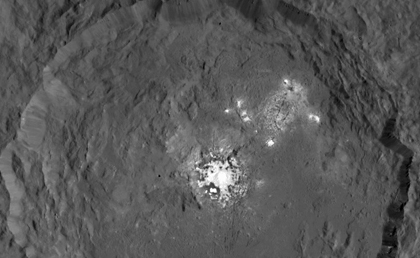
Cool image time! The image above is a newly released image of Occator Crater on Ceres, the location of the dwarf planet’s double bright spots, taken by Dawn in October.

I have cropped the image to focus on the crater and the bright spots. Unlike most previous images, this one is taken from an angle to bring out the topography, which also confirms what other data had shown, that the bright spots are not on top of any peaks. If anything, they appear to be located at low spots in the crater, as that previous data had suggested.

Though the spots are not really very bright, they are very bright relative to the dark surface of Ceres. This is why it is difficult to get a good image of them. Either you have to over-expose the spots to see the surface details around them, or under-expose the surface around them to see some detail in the spots. This image tries to find a middle ground.

Eventually they will move Dawn in very close to try to get higher resolution images of the spots alone. At that time we might finally be able to get a better understanding of what causes them.

0 comments

The first Ceres atlas

Ceres's first atlas

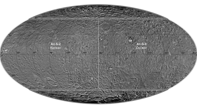
Using data during Dawn’s first orbit of Ceres German scientists have compiled a global atlas of the dwarf planet.

The images used for this are the wide angle survey images, which won’t show the smallest objects because they were taken from about 2,700 miles above the surface. Nonetheless, this atlas gives scientists a baseline for studying the giant asteroid.

1 comment

Dawn’s first close look at Ceres’s poles

Ceres's poles

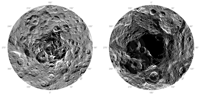
The Dawn science team have released their first images of the north and south poles of Ceres.

The region around the south pole appears black in this view because this area has been in shade ever since Dawn’s arrival on March 6, 2015, and is therefore not visible. At the north polar region, craters Jarovit, Ghanan and Asari are visible, as well as the mountain Ysolo Mons. Near the south pole, craters Attis and Zadeni can be seen.

0 comments

Dawn begins descent to final orbit around Ceres

Engineers have fired up Dawn’s ion engine and have begun lowering the spacecraft’s orbit downward.

The spacecraft is now on its way to the final orbit of the mission, called the low-altitude mapping orbit. Dawn will spend more than seven weeks descending to this vantage point, which will be less than 235 miles (380 kilometers) from the surface of Ceres. In mid-December, Dawn will begin taking observations from this orbit, including images at a resolution of 120 feet (35 meters) per pixel.

They’ve also released a nice mosaic showing the double bright spots in Occator Crater as well as the surrounding terrain.

0 comments

3D image of Comet 67P/C-G

Do you own red-blue 3-D glasses? Get them out and go to this link. Rosetta scientists have created a 3-D image of Comet 67P/C-G, including the jets of material shooting out from its surface.

[C]reating a 3d anaglyph of dynamic events like this is notoriously difficult: often the jets are too faint or their duration is too short to find two high-quality images taken several minutes apart that are suitable to pair together to create this type of view. However, the OSIRIS team got lucky with this particular event, capturing two images separated by about two-and-a-half minutes.

The image shows a bright, collimated jet embedded in a broader emission structure. The three dimensional perspective also reveals the conical shape of the jet and that the collimated feature is emitted towards the observer.

0 comments

Sunlight rolled the rocks on an asteroid

Scientists studying the rounded rocks on the surface of the asteroid 25143 Itokawa, photographed by the Japanese probe Hayabusa, have concluded that sunlight combined with the asteroid’s tiny gravity caused them move and thus erode themselves.

As sunlight bounced off the orbiting boulders, photons provided a tiny push. As they radiated back outward as heat, they triggered a recoil effect that added a gentle spin. Over time, these slowly spinning boulders bumped into each other with enough force to wear their edges into smooth surfaces.

Warning! This is only a model, and thus could very well be wrong. It is reasonable however and worth considering as a factor in studying the early formation history of asteroids.

0 comments

A new map of Ceres

The Dawn science team has released several new false color maps of Ceres, showing the dwarf planet’s topographic and compositional differences.

They have also assigned names to many of the features that Dawn has discovered, including Ysolo Mons for that large peak near the north pole.

0 comments

NASA pulls funding from private asteroid hunter

Because of a failure to meet its developmental deadlines, NASA has cut its ties with the privately funded Sentinel satellite, designed to spot 90% of all near Earth asteroids that might pose a threat to the Earth.

The problem for the B612 Foundation, the private company committed to building Sentinel, is that they haven’t clearly laid out a way any investors could make money from the satellite. Thus, they have so far raised only $1.6 million from private sources. They need almost half a billion to build it, according to their own budget numbers.

1 comment

Changes on the surface of Comet 67P/C-G

In a science paper now accepted for publication, the Rosetta science team have described changes that have occurred on the surface of Comet 67P/C-G from May through July of this year as the comet moved closer to the Sun and activity increased.

The changes were seen in a smooth area dubbed Imhotep.

First evidence for a new, roughly round feature in Imhotep was seen in an image taken with Rosetta’s OSIRIS narrow-angle camera on 3 June. Subsequent images later in June showed this feature growing in size, and being joined by a second round feature. By 2 July, they had reached diameters of roughly 220 m and 140 m, respectively, and another new feature began to appear.

By the time of the last image used in this study, taken on 11 July, these three features had merged into one larger region and yet another two features had appeared.

Be sure to click on the link to see the images. The changes look like a surface layer is slowing evaporating away.

1 comment

Rivers and lakes on Pluto?

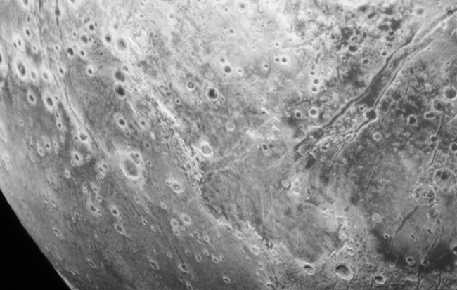
Cool image time! Though the New Horizons science team will likely not issue their next press release until Friday, they appear to be posting new images on their website on a daily basis. From those images I pulled out the one below, which to fit I have cropped and reduced slightly in size. Be sure to go to the full image.

Do you see what I see? It appears that there are meandering braided dry streambeds on Pluto, draining into what appears to be a large basin.

Rivers and lakes on Pluto?

Assuming my guess of what this is is correct, this is obviously not a streambed created by water. Earlier images showed nitrogen ice flows and glacier-like geology. It is possible this new image is observing evidence of past nitrogen riverbeds and nitrogen lakes.

Expect a very interesting press release from New Horizons later this week.

0 comments

Closing in on Ceres’s bright spots

Ceres's bright spots

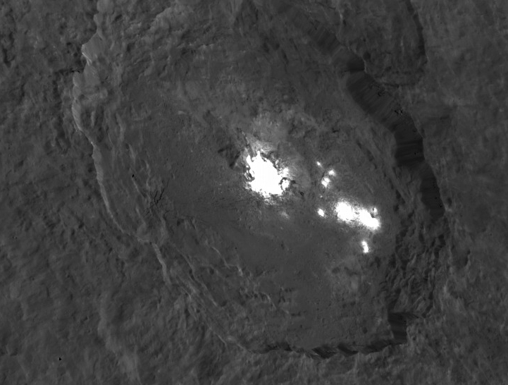
Cool image time! The Dawn science team has released a new close-up of Ceres’s Double Bright Spot.

The new up-close view of Occator crater from Dawn’s current vantage point reveals better-defined shapes of the brightest, central spot and features on the crater floor. Because these spots are so much brighter than the rest of Ceres’ surface, the Dawn team combined two different images into a single composite view — one properly exposed for the bright spots, and one for the surrounding surface.

They have also released a detailed topographic map of the crater as well as a fly-around video, which I have posted below the fold. The interesting take-away from this new data is that, while the bright spots look at first glance remarkably like the snow-cap on a mountain-top, they are actually at the low spots in the crater. This suggests that they are instead material that has either bubbled up from below, or flowed downward to the crater bottom.

Be sure you click on the link and look at the full resolution image.
» Read more

0 comments

Data from New Horizons does not match what is seen from Earth

The uncertainty of science: Planetary geologists are presently baffled by a conflict in the atmospheric data between New Horizons and data gathered from Earth.

On 29 June, a few weeks before the fly-by, Young organized astronomers across New Zealand and Australia to watch Pluto as it passed in front of a distant star. Tracking how the star’s light faded during the passage provided information on how much gas is in Pluto’s atmosphere. Using the same method, planetary scientists have seen the atmosphere grow denser since 1988 β€” and analysis of the 29 June observations shows that the trend remains intact. Young calculates that the current atmospheric pressure at Pluto’s surface is 22 microbars (0.022 pascals), or 22-millionths the pressure at sea level on Earth.

But on 14 July, New Horizons measured Pluto’s surface pressure as much lower than that Β­β€” just 5 microbars. β€œHow we link the two, we’re still working on,” says Cathy Olkin, a deputy project scientist for New Horizons at SwRI.

The difference could simply be that Pluto’s atmosphere is not smooth, that some regions are dense while others are thin, and New Horizons happened to look at a thin place. The Earth observations don’t have the resolution to separate the two.

There are other proposals to explain the problem. Regardless, the answer is likely hidden in the data from New Horizons that has still not been downloaded back to Earth. In a few months, all might very well become clear.

Or not, as is the natural state of science.

0 comments

New Horizons team picks its next Kuiper Belt target

The New Horizons science team has picked its next Kuiper Belt fly-by target beyond Pluto.

New Horizons will perform a series of four maneuvers in late October and early November to set its course toward 2014 MU69 – nicknamed β€œPT1” (for β€œPotential Target 1”) – which it expects to reach on January 1, 2019. Any delays from those dates would cost precious fuel and add mission risk. β€œ2014 MU69 is a great choice because it is just the kind of ancient KBO, formed where it orbits now, that the Decadal Survey desired us to fly by,” said New Horizons Principal Investigator Alan Stern, of the Southwest Research Institute (SwRI) in Boulder, Colorado. β€œMoreover, this KBO costs less fuel to reach [than other candidate targets], leaving more fuel for the flyby, for ancillary science, and greater fuel reserves to protect against the unforeseen.”

The press release includes some silly gobbly-gook about how the science team can’t announce this as its official target because they still have to write up a proposal to submit to NASA, which then must ponder their decision and decree it valid. We all know this is ridiculous. Will NASA sit and ponder and make them miss their target? I doubt it.

The fly-by itself will be really exciting, because this object will truly be the most unusual we will have ever gotten a close look at, as it has spent its entire existence far out in the dim reaches of the solar system.

7 comments
1 27 28 29 30 31 47