Has Aerojet Rocketdyne lost engine race with Blue Origin?

Aerojet Rocketdyne financial documents suggest that it has given up the bidding competition with Blue Origin to supply a rocket engine for ULA’s Vulcan rocket.

The latest financial release from aerospace manufacturer Aerojet Rocketdyne reveals that the company spent none of its own money on development of the AR1 rocket engine this spring. Moreover, the quarterly 10-Q filing that covers financial data through June 30, 2018 indicates that Aerojet may permanently stop funding the engine with its own money altogether—a sign the company has no immediate customers.

Although Aerojet will continue to receive some funding from the US military through next year to develop its large, new rocket engine, this money won’t be enough to bring it to completion. Instead of having a flight-ready engine for use by the end of 2019, the filing indicates that Aerojet now intends to have just a single prototype completed within the time frame.

Essentially this means ULA will have no choice but to pick Blue Origin’s engine, unless the Air Force pulls its weight and demands it take Aerojet rocketdyne, even if that means a significant delay before Vulcan can launch.

Dust storms spotted on Titan

Scientists reviewing Cassini data have identified dust storms for the first time of Saturn’s moon Titan.

When Rodriguez and his team first spotted three unusual equatorial brightenings in infrared images taken by Cassini around the moon’s 2009 northern equinox, they thought they might be the same kind of methane clouds; however, an investigation revealed they were something completely different. “From what we know about cloud formation on Titan, we can say that such methane clouds in this area and in this time of the year are not physically possible,” said Rodriguez. “The convective methane clouds that can develop in this area and during this period of time would contain huge droplets and must be at a very high altitude — much higher than the 6 miles (10 kilometers) that modeling tells us the new features are located.”

The researchers were also able to rule out that the features were actually on the surface of Titan in the form of frozen methane rain or icy lavas. Such surface spots would have a different chemical signature and would remain visible for much longer than the bright features in this study, which were visible for only 11 hours to five weeks.

In addition, modeling showed that the features must be atmospheric but still close to the surface — most likely forming a very thin layer of tiny solid organic particles. Since they were located right over the dune fields around Titan’s equator, the only remaining explanation was that the spots were actually clouds of dust raised from the dunes.

Obviously there are large uncertainties here. Nonetheless, the conclusion is a reasonable one, as it is expected that such dust storms would occur on Titan.

Posted just outside Zion National Park in the town of Springdale.

Greenhouse in Antarctica survives winter for 1st time

A greenhouse in Antarctica that is partly maintained remotely from Germany has survived through the polar winter for the first time.

Regularly withstanding temperatures below minus 40 degrees Fahrenheit (minus 40 degrees Celsius), the greenhouse provided herbs, lettuce and other vegetables to 10 people who were riding out the winter in the remote station, called the Alfred Wegener Institute’s Neumayer Station III. It’s the first time the greenhouse operated through the winter. “After more than half a year of operation in Antarctica, the self-sufficient greenhouse concept appears to be effective for climatically demanding regions on Earth, as well as for future manned missions to the moon and Mars,” DLR officials said in the statement.

“The harvests are now so plentiful that some of it does not always make it straight to the table, and we now have the luxury of spreading out our consumption of some refrigerated lettuce and herbs over several days,” Paul Zabel, a DLR researcher who works with EDEN ISS, said in the statement. “The overwintering team members are always looking forward to their next fresh meal.”

From a space exploration perspective, the most interesting aspect of this story is that, when the weather was too hostile for its Antarctic maintainer to reach it, the greenhouse was then maintained remotely from Germany, for up to three consecutive days. Clearly hands-on maintenance is necessary for such a facility, but to design it so that remote maintenance can occur is a technical capability that space-colonists are definitely going to want to have.

Japan successfully launches unmanned cargo ship to ISS

Japan today used a Mitsubishi H-2B rocket to successfully launch an unmanned cargo ship to ISS.

The cargo ship will take five days to rendezvous and dock with ISS. Its most interesting piece of cargo is a small capsule with a heat shield, designed to return experiment samples to Earth.

JAXA says the the capsule has an internal volume of about 30 liters, and astronauts could load up to 44 pounds (20 kilograms) of specimens inside the landing craft, which features a thermos-like container to store refrigerated biological samples. That is a fraction of the carrying capacity of the Dragon capsule, but the new HTV Small Return Capsule will offer station managers a new way to make sure time-critical items can return to Earth for analysis.

Astronauts will assemble the return capsule after the HTV arrives at the station, and mount it into position over the HTV’s forward hatch for deployment once the supply ship leaves the station.

The capsule, which carries no engines of its own, will jettison after the HTV completes its deorbit burn. The re-entry craft will deploy a parachute and splash down in the Pacific Ocean, where recovery teams will retrieve it and bring it back to Japan for inspections.

The leaders in the 2018 launch race:

25 China
16 SpaceX
8 Russia
7 ULA
5 Europe (Arianespace)
5 Japan

For Japan to be tied with Europe this late in the year either indicates that Europe is sagging, or Japan is growing. I suspect it is partly both. In the national rankings China still leads the U.S. 25 to 24.

Minerva probes send back first pictures

Ryugu's surface

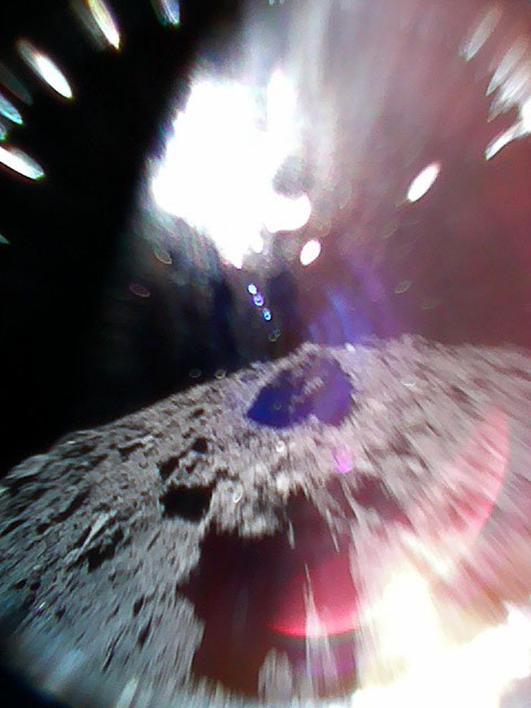
Super cool images! The two Minerva probes released two days ago from Hayabusa-2 have both sent back spectacular images from the surface of Ryugu.

The image on the right was captured by the rover dubbed 1A. I have rotated it to show the surface on the bottom, but the actual picture was taking during one of the rover’s bounces while it was moving, so the returned picture had the surface on left. The white brightness is from sunlight. From the press release:

We have confirmed both rovers landed on the surface of asteroid Ryugu. The two rovers are in good condition and are transmitting images and data. Analysis of this information confirmed that at least one of the rovers is moving on the asteroid surface.

MINERVA-II1 is the world’s first rover (mobile exploration robot) to land on the surface of an asteroid. This is also the first time for autonomous movement and picture capture on an asteroid surface. MINERVA-II1 is therefore “the world’s first man-made object to explore movement on an asteroid surface”. We are also delighted that the two rovers both achieved this operation at the same time.

Other released images were taken just after release. One shows a blurred picture of Hayabusa-2, while the other sees Ryugu’s surface below.

Both of these rovers are designed to travel on the surface by a series of hops, taking advantage of Ryugu’s tiny gravity. There will be more images I’m sure from them in the coming days.

Russia considering getting out of Gateway

The new colonial movement: In expressing a desire not to play a secondary role in its next space station, Roscosmos head Dmitry Rogozin said today that Russia might pull out of its partnership with NASA in building its Gateway lunar station.

Russia agreed last year to work with the U.S. National Aeronautics and Space Administration (NASA) on plans for the moon-orbiting Deep Space Gateway, which will serve as a staging post for future missions.

But the head of Russian space agency Roscosmos, Dmitry Rogozin, said Russia might exit the joint program and instead propose its own lunar orbit space station project. “The Russian Federation cannot afford to play the second fiddle role in it,” he was quoted as saying by the RIA news agency, without much further elaboration.

A spokesman for Roscosmos said later that Russia had no immediate plans to leave the project.

Russia’s problem is that they simply don’t have the cash to build their own lunar station. They could build a new station of their own in Earth orbit, and that might be what they end up doing. In fact, based on the knowledge they gained from both Mir and ISS, they might be able to design that station for short interplanetary flights, such as to the Moon and back, once built.

If I was Rogozin, that is exactly what I would do. Get out of NASA’s boondoggle, and build something in Earth orbit that will really demonstrate interplanetary travel.

Mountains on the Moon

Mountains on the Moon

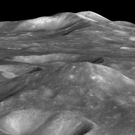
Cool image time! The image on the right, reduced slightly to post here, shows several high mountains on the far side of the Moon. If you click on the image you can see it at full resolution.

The summit of the unnamed peak in the foreground (50.2° S, 236.6° E) has an elevation of 6710 meters, about 7000 meters (about 23,000 feet) of relief relative to the low point at the bottom of the image. The two peaks on the horizon, 200 kilometers in the distance (about 125 miles), have summit elevations of 4320 meters (14,200 feet) and 4680 meters (15,350), respectively and both rise more than 6000 meters (almost 20,000 feet) above their surroundings.

In the Lunar Reconnaissance Orbiter (LRO) science team release in June, they noted that the high peak here is actually taller than Denali (Mount McKinley), the highest peak within the U.S. And it has no name. They also note that the peak is likely 4 billion years old, and has experienced extensive erosion in that time, meaning that it is also likely shorter than it once was.

I don’t have anything to add, other than this would be an amazing place to put up a resort, with trails taking you to the top of the mountains. In the lighter gravity, the hike would actually be somewhat easy, even wearing a spacesuit. And you wouldn’t have to worry about a thinning atmosphere as you climbed higher, as you do on Earth. You’d be carrying it with you.

Want to look at every planetary map ever made? You can!

Two Polish academics have created a web-available catalog intended to contain every planetary map ever created, beginning in 1600 through the present.

“Our catalogue is being updated regularly with both newly resurfaced historic maps and new additions. For the future, we plan to add maps that have been published in journal articles and digitize maps that do not yet include GIS formats,” added Hargitai. “We live in a transition period where static maps that characterized the last 400 years may become extinct, replaced by dynamic digital map services and tools. In the digital platforms it is becoming difficult even to define what we consider to be a ‘map’, and not just layers of spatial data. Maps are used for mission planning, surface operation, and post-mission analysis. In the near future, they will be key components of planning and operating new human missions.”

The website is here. At the moment the catalog seems significantly incomplete, with only several hundred maps available. Hopefully this will expand with time.

Stratolaunch considering launching hypersonic rocket tests from its Roc airplane

Capitalism in space: Stratolaunch is now considering building and launching hypersonic rocket test program using its giant Roc airplane.

In the concept study presented this week, Corda and his colleagues provide a detailed description of a delta-wing testbed plane called the Hyper-Z. It would be 83.4 feet long, with a wingspan of 32.4 feet and a launch weight of about 65,000 pounds.

Stratolaunch’s hydrogen-fueled PGA rocket engine would serve as the plane’s main propulsion system, but it could also be equipped with an air-breathing propulsion system, such as a scramjet engine. The flight profiles could accommodate a maximum speed of Mach 11, or a maximum altitude of 477,000 feet.

Hyper-Z would be launched from Stratolaunch’s mammoth twin-fuselage carrier airplane [Roc], which has a record-setting wingspan of 385 feet.

I must emphasize that this is only a concept proposal at this point. The company still has to verify the operation of Roc.

What this proposal does suggest to me is that the company is still struggling to find a profitable use for Roc, and customers to go along with it. This concept appears to be a lobbying effort to both the military and NASA, offering them Roc as a testbed for such flight tests.

NOAA awards three more experimental commercial weather contracts

Capitalism in space: NOAA this week awarded three commercial companies contracts to provide the agency weather data in its expanding effort to get this data not from government satellites but from private sources.

In the Sept. 17 announcement, NOAA said it was issuing contracts to GeoOptics, PlanetIQ and Spire to provide GPS radio occultation weather data from satellites currently in orbit or planned for launch in the coming months. That technique measures the refraction of GPS signals as they pass through the atmosphere and are received by the companies’ satellites, which can provide temperature and pressure profiles to support weather forecasting models.

The awards represent round two of NOAA’s Commercial Weather Data Pilot program, an effort by the agency to experiment with buying data from commercial providers to determine its usefulness, as well as to examine various technical and programmatic issues with such data buys.

NOAA’s management bureaucracy has resisted this transition to private enterprise, much as NASA’s bureaucracy has. Nonetheless, NOAA’s inability to built and launch weather satellites at a reasonable cost and in a practical timeframe is forcing it to change.

Rocket Lab signs another satellite launch contract

Capitalism in space: Rocket Lab has signed another satellite launch contract, this time with the Luxembourg-based company Kleos Space.

US orbital launch provider Rocket Lab has signed a contract with Luxembourg-based satellite technology company Kleos Space to launch the scouting mission satellites that will geolocate maritime radio to guard borders, protect assets and save lives.

The multi-satellite system of the Kleos Scouting Mission (KSM) will form the cornerstones of a 20-system constellation that will geolocate VHF transmissions from marine vessels to provide global activity-based intelligence data as a service. The Kleos Space constellation will detect radio transmissions and pinpoint their origin and timing, enabling governments and organizations to detect activity such as drug and people smuggling, illegal fishing and piracy, and also identify those in need of search and rescue at sea.

The contract is for launches in mid-2019, which suggests that Rocket Lab is increasingly confident that it will be able to ramp up operations significantly once it makes its next two launches in November and December.

Hayabusa-2 sees its shadow

Ryugu, with Hayabusa-2's shadow

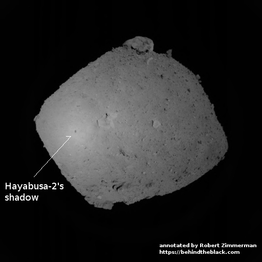
During its aborted landing rehearsal last week Hayabusa-2 imaged its own shadow as it approached within 600 meters of Ryugu.

The shadow is only a little dot on the surface of the asteroid, but to have resolved it is quite impressive. The image on the right has been annotated by me to indicate the shadow.

They have not said when they will do another landing rehearsal. Meanwhile, two of the spacecraft’s mini-landers are expected to be released sometime in the next few days.

Update: Based on the raw navigation images being released in real time from Hayabusa-2, the release of the MINERVA-II-1 has begun, with Hayabusa-2 moving in towards Ryugu in preparation for that release.

Curiosity has problem sending back its stored data

The science team running Curiosity found this week that the rover is suddenly unable to send back its stored data.

Over the past few days, engineers here at JPL have been working to address an issue on Curiosity that is preventing it from sending much of the science and engineering data stored in its memory. The rover remains in its normal mode and is otherwise healthy and responsive.

The issue first appeared Saturday night while Curiosity was running through the weekend plan. Besides transmitting data recorded in its memory, the rover can transmit “real-time” data when it links to a relay orbiter or Deep Space Network antenna. These real-time data are transmitting normally, and include various details about the rover’s status. Engineers are expanding the details the rover transmits in these real-time data to better diagnose the issue. Because the amount of data coming down is limited, it might take some time for the engineering team to diagnose the problem.

On Monday and Tuesday, engineers discussed which real-time details would be the most useful to have. They also commanded the rover to turn off science instruments that were still on, since their data are not being stored. They’re also preparing to use the rover’s backup computer in case they need to use it to diagnose the primary computer. That backup computer was the rover’s primary one until Sol 200, when it experienced both a hardware failure and software issue that have since been addressed.

In other words, the rover is functioning, they can communicate with it in real time, but any data stored on board for some reason is not being transmitted.

The volcano Llullaillaco

Llullaillaco volcano in South America

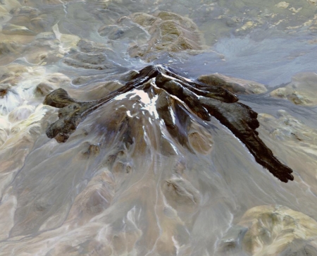
Cool image time! The image on the right, cropped and reduced to post here, shows a volcano not on Mars or the Moon or any of the moons of Jupiter or Saturn, but here on Earth in South America!

Llullaillaco is a stratovolcano at the border of Argentina and Chile. It lies on a high plateau close to the Atacama Desert. At an elevation of 6723 m ASL, it is the second highest active volcano in the world. About 150,000 years ago the volcano’s southeastern flank collapsed, producing a debris avalanche that traveled 25 kilometers. The youngest dated rocks are about 5600 years old; but there are local reports of activity from the 1800s. The perspective image looking east was acquired December 19, 2014.

If you click on the link you can see the full image. It was taken by one of the instruments on the Earth-observation satellite Terra, launched in December 1999. Though the website for this image does not state so, I suspect that some of the colors we see here are false colors, as some of the data comes from the infrared.

Update on SpaceX and Boeing’s private commercial crew capsules

Link here. The key piece of news is that both companies now believe they meet NASA’s safety requirements.

[D]uring a panel discussion at the American Institute of Aeronautics and Astronautics (AIAA) Space Forum here Sept. 18, executives of the two companies said they now believed their vehicles met that and related safety requirements.

John Mulholland, vice president and program manager for the commercial crew program at Boeing, said the company was assessing three separate requirements, including the overall loss of crew as well as ascent and entry risks and loss of mission. “Our teams have been working that for a number of years,” he said, noting those analyses have driven changes to the vehicle design, such as increased micrometeoroid and orbital debris protection. “Where we are now is that our analysis shows we can exceed the NASA requirements for all three of those criteria,” he said.

Benjamin Reed, director of commercial crew mission management at SpaceX, said his company was in a similar situation. “We’re looking right now to be meeting the requirements,” he said.

Kathy Lueders, NASA’s commercial crew program manager, didn’t confirm that the companies have, in fact, met those safety requirements. “We’re learning from a NASA perspective about how to understand the assessments that we’re getting from each of the contractors and how to apply it,” she said. “We at the NASA team are assessing the modeling that each of the providers has done.”

It should be understood that the requirements being discussed here really have nothing to do with actual engineering, but are based on a statistical analysis that estimates the risk to any passenger. In other words, it is a pure guess, and can be manipulated any way anyone wants. This is why NASA’s manager above is so vague. What she is really saying is that NASA is slowly being forced to accept the analysis of the contractors.

The article at the link also details the present schedule, which appears mostly unchanged (though Musk indicated there might be a slight delay in Dragon during his BFR presentation earlier this week), and the efforts by both companies to make their capsules reusable.

British test satellite uses net to capture target

A British test satellite has successfully used a net to capture a cubesat target, demonstrating the technology that someday could be used to clean space junk from Earth orbit.

“It worked just as we hoped it would,” said Prof Guglielmo Aglietti, director of the Surrey Space Centre. “The target was spinning like you would expect an uncooperative piece of junk to behave, but you can see clearly that the net captures it, and we’re very happy with the way the experiment went.”

If this were a real capture, the net would be tethered to the deploying satellite, which would then tug the junk out of the sky. As this was just a demonstration, the net and the box (which was actually pushed out from RemoveDebris to act as a target) will be allowed to fall to Earth on their own. Their low altitude means it should take only a couple of months before they burn up in the atmosphere.

I have embedded below the fold a video showing the net capture. It is quite spectacular. This was one of three different experiments on RemoveDebris that are testing space junk removal methods. The next is the use of a harpoon.
» Read more

China’s Long March 3B rocket successfully launches two GPS-type satellites

The new colonial movement: China today successfully launched two more of its Beidou GPS-type satellites, using its Long March 3B rocket.

The rocket launched from the Xichang Satellite Launch Center in southwest China, and almost certainly dropped its stages near habitable regions, as happened in June. The question is whether China has successfully clamped down on the distribution of any images of such events, taken by local residents. It failed to do so in June.

The leaders in the 2018 launch race:

25 China
16 SpaceX
8 Russia
7 ULA
5 Europe (Arianespace)

This launch puts China once again in the lead over the U.S. in the national rankings, 25 to 24. Moreover, with every launch this year China extends its new record for the most launches by that nation in a year.

All instruments check out on the Parker Solar Probe

The initial check out of the Parker Solar Probe, now on its way to the Sun, has shown all instruments are functioning properly.

“All instruments returned data that not only serves for calibration, but also captures glimpses of what we expect them to measure near the Sun to solve the mysteries of the solar atmosphere, the corona,” said Nour Raouafi, Parker Solar Probe project scientist at the Johns Hopkins University Applied Physics Lab in Laurel, Maryland.

The mission’s first close approach to the Sun will be in November 2018, but even now, the instruments are able to gather measurements of what’s happening in the solar wind closer to Earth.

The spacecraft will make its first fly-by of Venus in October.

New data says going to Mars involves significant radiation exposure

New data from Trace Gas Orbiter, part of Europe’s ExoMars project, says a journey to Mars will expose humans to significant radiation.

The results imply that on a six-month journey to the Red Planet, and assuming six-months back again, an astronaut could be exposed to at least 60% of the total radiation dose limit recommended for their entire career.

The ExoMars data, which is in good agreement with data from Mars Science Laboratory’s cruise to Mars in 2011–2012 and with other particle detectors currently in space – taking into account the different solar conditions – will be used to verify radiation environment models and assessments of the radiation risk to the crewmembers of future exploration missions.

This data was gathered during the spacecraft’s journey to Mars during a time of falling solar activity. Thus, the radiation exposure came more from cosmic rays than from solar activity.

A Martian shoreline?

Collapsing cliff in Tempe Fossae

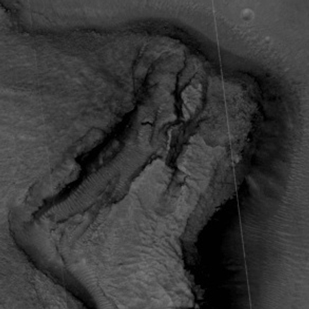
Cool image time! The image on the right, reduced and cropped to post here, was part of the August 31 image release from the high resolution camera of Mars Reconnaissance Orbiter (MRO). (Click on the image to see the full image.) It shows a slowly separating cliff feature in a region dubbed Tempe Fossae

As part of that monthly mass release, no caption was provided for this image. However, we can gain some understanding by looking at the larger context.

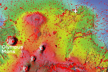
Tempe Fossae is located at the margins between the low flat northern plains and the high southern highlands. The location is also part of the vast drainage region to the east of Mars’ gigantic volcanoes. This is obvious from the overview image below and on the right. The location of this image is indicated by the white cross.

Mars overview

In this area of that drainage the canyons appear to follow southwest to northeast trending fault lines. Tempe Fossae is one of the smaller of these canyon complexes. All however appear to drain out into the northern plains.

Most of the MRO images of features in this area focus on the canyon cliffs. This image however focused on this one isolated small cliff in the middle of the canyon. To my eye it appears that these features document the slow drying of that vast intermittent ocean in Mars’s northern plains. The cliff is actually two steps, with the higher one appearing to mark an older shoreline. The lower cliff is abutted by a low flat area where it appears as if there had once been ponded water, now dried.

close-up of cracked area

The cracks in the cliff itself suggest it is slowly breaking apart and falling down towards that low flat area. In fact, the entire feature reminds me of the sand cliffs that are sometimes found along shorelines. The sand is not very strong structurally, and with time sections will separate and then fall down. The image to the right zooms in on this cracked region. The presence of sand dunes reinforces my impression.

I imagine that as the water drained down from the glaciers on the sides of the volcanoes and filled that intermittent sea, the shoreline regions would have had the most water. At Tempe Fossae the canyons might have been partly filled. As the water level drained out and lowered, first the upper cliff edge was exposed, then the lower. The draining water probably helped created these cracks as it flowed down through them.

Finally, the last remaining pits of water ponded at the base of the cliff, eventually drying out. With time, the weakly structured sand cliffs, already carved partly by the flowing water, began to slump apart and fall downward, producing the cracks we now see. I expect that some time in the near future, on geological time scales, there will be a landslide and the outer section will collapse downward.

Vulcan found?

Scientists have found a super-earth orbiting 40 Eridani-A, a star located sixteen light years away and proposed by Gene Roddenberry in 1991 as the home star for his race of logical Vulcans.

It turns out the letter authors’ prediction was right — a world really does orbit the primary star of the three-star 40 Eridani system. (Whether it’s home to a logic-based alien society, though, is anyone’s guess!)

The world is a super-Earth, the most common type of planet in the galaxy (though a type that’s missing from our solar system). At twice Earth’s radius and eight to nine times its mass, 40 Eridani b sits on the line that divides rocky super-Earths from gaseous ones. The planet orbits its star every 42 days, putting just inside the system’s habitable zone — in other words, where it’s nice and hot. At 16 light-years away, it’s the closest super-Earth known and therefore a good potential target for followup observations.

The discovery was made by a survey taking place using a relatively small telescope right here in the Tucson area, on top of Mount Lemmon. Most cool!

Instrument on GRACE-FO fails

The U.S/German science two-satellite constellation, launched in May, has not gathered any science data since July because one instrument on one satellite has shut down.

It appears the problem is related to an electrical problem. The article provides little information, though they say they will switch to a back up system later this month. I wonder why this has taken so long.

The article at the link calls this “a glitch.” That is a lie and bad journalism. Any failure that shuts down a spacecraft for months and requires the use of a back up is a major failure, not a mere “glitch.” I wish news organizations would stop using that word, as it only exists to help minimize the seriousness of a problem.

Curiosity fails again to drill into Vera Rubin Ridge

For the third time Curiosity has failed to drill into the rock on top of Vera Rubin Ridge.

Last night we learned that our drill attempt on “Inverness” was not successful, reaching only 4 mm into the rock.

The only successful drill attempt on the ridge occurred when they moved down off the top of the ridge to a slightly lower geological layer.

They are moving Curiosity to another candidate drill site on the ridge, where they will try again. While they imply in their reports that it is solely the hardness of the ground that is stopping them, I still wonder if the improvised drill technique, using the robot arm to push down rather than the drill’s jammed feed mechanism, is partly to blame. I would think that they have placed limits on how hard the arm can push to protect it.

SpaceX’s first BFR passenger is Yusaku Maezawa, owner of Japanese fashion company

Yusaku Maezawa

Capitalsm in space: SpaceX’s first BFR passenger will be Yusaku Maezawa, the owner of Japanese fashion company, shown on the right.

Maezawa began his statement by echoing John Kennedy with these words, “I choose to go to the Moon.” He purchased the entire first flight, and will invite six to eight artists to join him on the flight and ask them to create art afterward inspired by the flight. They are aiming for a launch in 2023.

BFR

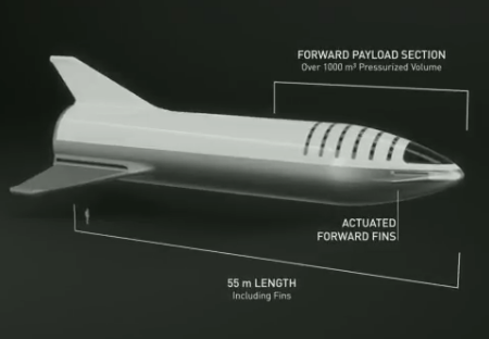
Musk began the presentation tonight with an overview of the status of BFR, noting that they plan unmanned test launches before putting humans on the rocket. The image an the right shows the habitable upper stage.

During the question and answer session after the announcement Musk was asked questions about the present stage of BFR design, and whether it has been finalized. He said they plan “a lot of test flights” and are aiming for first orbital flights in 2 to 3 years, “if things go really well.”

Musk made it clear that Maezawa chose SpaceX for the flight, rather than the other way around. Musk also said that Maezawa was paying them a lot of money for the flight, though they were not going to reveal the amount. Musk did note that the price was not trivial, and that Maezawa has already made a significant deposit. Maezawa had first approached them for a Dragon/Falcon Heavy flight, but because of the limitations of of those spacecraft, they decided it better to go with the bigger rocket.

Musk noted that the first test hops of the upper stage to test its landing capabilities will take place at Boca Chica in Texas. The launch site for the orbital missions is not yet decided.

Musk estimated that the cost for developing BFR is going to probably be around $5 billion, which he also noted rightly is quite small for this kind of project. He also said that right now they are only devoting 5% of SpaceX’s resources to this mission. As they complete the crew Dragon project, they will then begin to shift resources to BFR. He estimated that will happen sometime late next year.

Overall, it strikes me that they really do not have all the details yet worked out, with the rocket or their flight schedule. As Musk openly admitted when asked if they are sure about the schedule, “We are definitely not sure.” This is not necessarily a bad thing, since it is often better to keep an open-mind in planning something this ambitious. At the same time it tells us not to expect any of this to happen, as described.

One final point: Musk at one point said he wants a base on the Moon. “It’s 2018, why don’t we have a base on the Moon?” To me, this was an almost direct dig at NASA’s Gateway/FLOP-G project, which isn’t a base but locks us in lunar orbit. Musk was being very careful to avoid criticizing NASA, his biggest customer, but anyone who knows what is going on will quickly recognize that BFR is in direct competition with SLS/Orion/Gateway.

Based on SpaceX’s history, going from first orbit flight to flying the world’s largest rocket in only ten years, I am very confident that this company could get that first base on the Moon, long before NASA even gets Gateway launched.

Cryo-volcanism had less influence on shaping Ceres than predicted

The uncertainty of science: A careful analysis of the Dawn data has found that though cryo-volcanism has occurred repeatedly on Ceres, it had less influence on the dwarf planet’s surface than previous models had predicted.

At the same time, the data also suggests that Ceres has been more active throughout its history than predicted. They found about 22 domes that are apparently past cryo-volcanoes that have flattened out.

“Given how small Ceres is, and how quickly it cooled off after its formation, it would be exciting to identify only one or two possible cryovolcanoes on the surface. To identify a large population of features that may be cryovolcanoes would suggest a long history of volcanism extending up to nearly the present day, which is tremendously exciting,” said Sizemore. “Ceres is a little world that ought to be ‘dead,’ but these new results suggest it might not be. Seeing so much potential evidence for cryovolcanism on Ceres also lends more weight to discussions of cryovolcanic processes on larger icy moons in the outer solar system, where it’s likely more vigorous.”

Multiple launches today

Two launches today:

  • ULA’s last Delta 2 rocket launches ICESat-2 icecap tracking satellite for NASA
  • Indian’s PSLV rocket launches two British satellites

More details about ICESat-2 can be found here.

The PSLV launch raises India’s 2018 launch total to 4, tying Japan. The leaders in the 2018 launch standings:

24 China
16 SpaceX
8 Russia
7 ULA
5 Europe (Arianespace)

The U.S. and China are once again tied at 24 each.

Russians considering spacewalk as part of airleak investigation

The Russians are now considering having their astronauts on ISS do a spacewalk to inspect the outside of the Soyuz capsule for evidence of sealant work at the location of the drill hole that caused the airleak.

If the spacewalk is attempted, the cosmonauts would have to get to the Habitation Module, peel off soft thermal layers blanketing the spacecraft and then cut through the meteoroid shielding bordering this section of the spacecraft at a distance of around 1.5 centimeters from its pressurized hull.

To access the area of the hole on the exterior of the Soyuz, Russian officials are developing a spacewalk scenario relying on the available Strela boom, GStM. The telescopic device can be used to carry a cosmonaut secured to a special anchor at the end of the boom to a location aboard the station otherwise inaccessible to spacewalkers due to lack of railings.

The spacewalk would take place sometime in November or December. The goal is to help confirm that the sealant work was done on the ground, as well as help pinpoint when.

Soyuz capsule was drilled after it was fully assembled

The investigation into the drillhole leak in the Soyuz capsule docked to ISS has revealed that it had to have been done after the capsule was fully assembled.

“During the analysis of those images, traces of drilling were found on the anti-meteorite shield,” the source said, adding that “the top of the drill came through the pressure hull and hit the non-gastight outer shell.”

According to another industry source, the non-gastight anti-meteorite protection is installed right before the spacecraft is taken to the final assembly workshop. “When Soyuz MS-09 has just arrived to the final assembly workshop, it was photographed in details. No hole and no signs of drilling… were found. The spacecraft was drilled later, when it was fully assembled,” the source said. He added that the anti-meteorite shield was also photographed before being installed, and no traces on it were found as well.

The source suggested that the spacecraft could be damaged either during the very last stage of works or during its 90-day stay in the checkout stand, adding that it was highly unlikely that the damage occurred during the transportation to the Baikonur space center in Kazakhstan or at the launch facility.

This narrowing of the time frame for the drilling will increase the chances that the Russians will be able to identify who did.

1 229 230 231 232 233 453