Big mountains everywhere inside Valles Marineris

Big mountains in Valles Marineris
Click for original image.

While the giant canyon Valles Marineris on Mars is known best as the biggest known canyon in the solar system — large enough to cover the continental United States several times over — that size tends to diminish the mountainous nature of its interior. Today’s cool image attempts once again (see for example these earlier posts here, here, here, here, and here) to illustrate that stupendous and mountainous nature.

The picture to the right, rotated, cropped, reduced, and sharpened to post here, was taken on May 15, 2023 by the high resolution camera on Mars Reconnaissance Orbiter (MRO). The goal of the picture was to get a better view of the numerous layers of this terraced cliff wall. What I see, however from my tourist’s perspective, is a steep wall that descends almost 4,500 feet from the high to the low point in just over three miles. This is as steep if not steeper than the walls of the Grand Canyon.
» Read more


2 comments

Where the Martian landscape begins to dry out

Where Mars begins to dry out
Click for original image.

Today’s cool image to the right, cropped, reduced, and sharpened to post here, provides us a glimpse at the lower mid-latitudes of Mars where the terrain is beginning to dry out as we move south. The picture was taken on April 29, 2023 by the high resolution camera on Mars Reconnaissance Orbiter (MRO), and shows what the scientists label “large linear features.”

The main north-south ridge is only about 20-25 feet high, and its meandering nature (which can be seen more clearly in the full image) suggests it is possibly an inverted channel, formed when the bed of a former canyon gets compressed by the water or ice that flows through it, and when the surrounding terrain gets eroded away that channel bed becomes a ridge.

These ridges however could also possibly be volcanic dikes, where magma had pushed up through fractures and faults to form these more resistant ridges.
» Read more

0 comments

The very tip of a thousand-mile-long crack on Mars

The very tip of a 1000-mile-long Martian crack
Click for original image.

Cool image time! The picture to the right, rotated, cropped, reduced, and sharpened to post here, was taken on June 22, 2023 by the high resolution camera on Mars Reconnaissance Orbiter (MRO). It shows what the scientists label as “The tip of Cerberus Fossae,” a thousand-mile-long crack in the surface of Mars formed when the ground was pulled apart by underground forces.

If you look closely at the picture’s right edge, you can see that beyond the end of the fissure it actually continues but appears filled with material. In the full picture this however is the end of the crack. Beyond this point the ground is as smooth and as generally featureless as seen within the picture itself, and as also shown in this MRO context camera view of the same area.

Cerberus Fossae is actually three parallel cracks, with this the northernmost one. The eastern tip of the middle crack was previously highlighted in a cool image in July 2022.
» Read more

0 comments

A Martian wedding cake surrounded by brain terrain

Brain terrain surrounding a Martian wedding cake
Click for original image.

Of all many cool images I’ve posted, today might take the cake (pun intended) for the best illustration of the alien nature of Mars. The picture to the right, cropped, reduced, and sharpened to post here, was taken on June 28, 2023 by the high resolution camera on Mars Reconnaissance Orbiter (MRO), and shows what the scientists simply label as “flow features.”

I personally don’t see any obvious flow features in the full image, unless one wants to call the brain terrain that covers this entire plain a flow feature. Brain terrain is a feature unique to Mars whose origin remains a mystery to geologists. As noted by scientists in captioned MRO image in 2019:

You are staring at one of the unsolved mysteries on Mars. This surface texture of interconnected ridges and troughs, referred to as โ€œbrain terrainโ€ is found throughout the mid-latitude regions of Mars.

…This bizarrely textured terrain may be directly related to the water-ice that lies beneath the surface. One hypothesis is that when the buried water-ice sublimates (changes from a solid to a gas), it forms the troughs in the ice. The formation of these features might be an active process that is slowly occurring since HiRISE [MRO’s high resolution camera] has yet to detect significant changes in these terrains.

The wedding cake inside the small crater to the upper right only adds to the alienness of this terrain.
» Read more

1 comment

Watch the landing attempt of Chandrayaan-3’s Vikram lander on August 23, 2023


Click for interactive map.

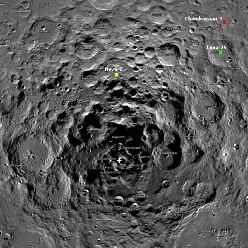
After separating from its Chandrayaan-3 propulsion module on August 17, 2023, India’s Vikram lunar lander has been slowly making orbital adjustments in preparation for its landing attempt on August 23rd.

I have embedded the live stream of that landing attempt below. As it is scheduled for 6:04 pm (India time), in India, in the U.S. that landing will occur in the early morning hours of August 23rd.

Following the failed crash on the Moon of Russia’s lunar lander Luna-25 yesterday, this landing attempt is likely to garner a lot more interest. It is also India’s second attempt, having failed in 2019 when its Vikram lander ran out of fuel before landing and crashed.
» Read more

4 comments

Mars’ endless cycles of glacial activity

Overview map

Mars' endless cycles of glacial activity
Click for original image.

While the images being sent to us from Mars Reconnaissance Orbiter (MRO) repeatedly show features that appear convincingly like glaciers, the data is also beginning to tantalize us with evidence of the endless glacial cycles that have occurred on Mars.

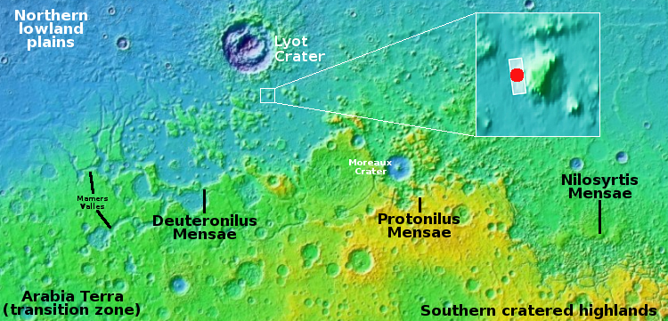
The picture to the right, cropped, reduced, and sharpened to post here, was taken on June 27, 2023 by MRO’s high resolution camera. The red dot in the inset of the overview map above shows the location, the western flanks of an apron that surrounds a 3,800-foot-high mesa in the chaos region Deuteronilus Mensae, the western end of the 2,000-mile-long mid-latitude strip of chaos regions I dub glacier country, because every image seems to show some form of glacial feature.

Today’s picture is no different. The apron shown here drops the last 1,000 feet of the mesa’s total 3,800-foot height, during which it shows dozens of what the scientists label “parallel lines.” These lines likely reveal the layers of glacial ice in this apron, with the older layers larger and more extensive. Apparently, with each growth cycle the glacier obtained less snow from the atmosphere, so the more recent layers grew less.

In other words, the amount of water on Mars has been declining with time.

Untangling these numerous layers will undoubtedly give us a remarkably detailed history of Mars entire geological history. Unfortunately, that untangling cannot happen until we have boots on the ground, on Mars, able to drill core samples from many different places.

0 comments

Luna-25 takes first image of lunar surface

Luna-25's first lunar image
Click for interactive map. Zeeman is located on the lower left.

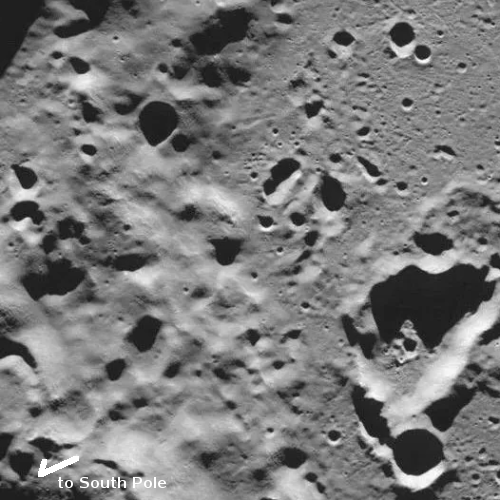
Russia’s state-run press today issued the first picture taken by Luna-25 after entering lunar orbit two days ago. That picture, to the right and cropped and reoriented to post here, shows part of Zeeman Crater at 75 degrees south latitude and 135 degrees west, on the far side of the Moon. From the TASS announcement:

“The Luna-25 spacecraft, flying in a circular orbit as the Moon’s artificial satellite, has taken pictures of the lunar surface with television cameras of the STS-L system. The image, taken today at 08:23 Moscow time, shows the southern polar crater Zeeman on the far side of the Moon. The coordinates of the crater center are 75 degrees south and 135 degrees west,” the state corporation said. Roscosmos said the Zeeman crater is of great interest to researchers. Its rim rises eight kilometers above its relatively flat floor.

The picture shows Zeeman’s southern rim to the left, with its pockmarked crater floor to the right. The crater the lander is targeting, Broguslawsky Crater, sits in the opposite hemisphere of Zeeman, slightly closer to the south pole but on the Moon’s near side.

3 comments

The inexplicable behavior of Martian dust devils

The inexpicable behavior of Martian dust devils
Click for original image.

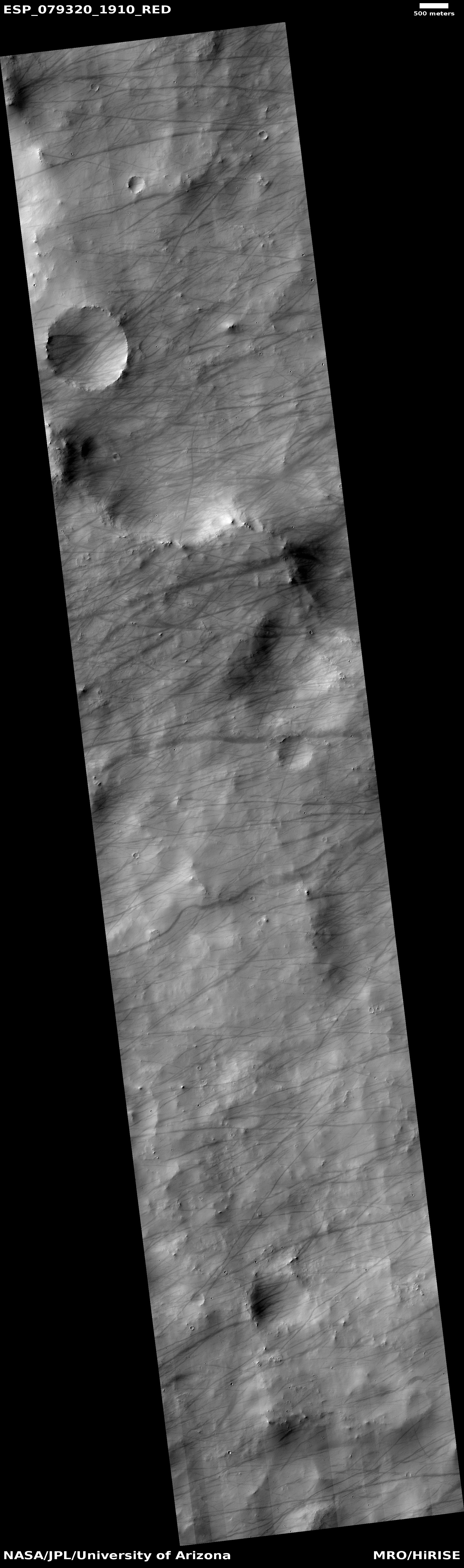
Today’s cool image illustrates the puzzling inclination of Martian dust devils to strongly favor specific regions on the Martian surface, for reasons that at present no one can confidently explain.

The picture to the right, rotated, cropped, reduced, and sharpened to post here, was taken on June 28, 2023 by the high resolution camera on Mars Reconnaissance Orbiter (MRO). It shows a plethora of dust devil tracks, almost all of which have an east-west orientation. Moreover, the tracks seem uninfluenced by the surface topography, continuing on their path without deviation, even as they cross cliffs, craters, and mounds. The orientation tells us the direction of the prevailing winds, though I don’t know if those winds blow to the east or to the west.

What makes this image revealing is that a gathering of such dust devil tracks is seen so rarely in other MRO high resolution photographs. I look at a lot of MRO pictures, and though dust devil tracks are not rare, most images don’t show this many. Apparently, there are specific conditions on Mars that cause a lot of tracks to appear in specific locations, either because atmospheric conditions create a lot more dust devils, or the ground conditions allow the tracks to become more visible.
» Read more

6 comments

Chandrayaan-3’s Vikram lander separates from its propulsion module; Luna-25 in lunar orbit


Click for interactive map.

The two probes aiming to land in the high southern latitudes of the Moon in the next week are now both in lunar orbit and preparing for their planned landings.

First India’s Chandrayaan-3: With its propulsion module having completed the job of getting Chandrayaan-3 from Earth to lunar orbit, the Vikram lander today separated from that module in preparation for firing its own engines on August 23, 2023 and landing on the Moon.

Vikram needs to make several orbital adjustments before that landing attempt.

Second, Russia’s Luna-25 probe entered lunar orbit yesterday, where it will spend the next few days making its own orbital adjustments before attempting its landing on August 21st.

Vikram carries a small rover, Pragyan. Luna-25 is only a lander, though it has a scoop and will do analysis of the lunar soil below it. Neither is landing “near the south pole”, as most news sources are saying. They are landing at latitudes comparable to landing in the Arctic on Earth, on the northern coast of Alaska. As such, neither will find out anything about the question of remnant ice in south pole’s permanently shadowed regions.

5 comments

An avalanche in the West Virginia of Mars

An avalanche in the West Virginia of Mars
Click for original image.

Cool image time! The picture to the right, rotated, cropped, and reduced to post here, was taken on June 27, 2023 by the high resolution camera on Mars Reconnaissance Orbiter (MRO).

I have cropped it to focus on this one hill, about 900 feet high (though the elevation data from MRO is somewhat uncertain at this resolution), because of that major landslide on its northern slopes. At some point in the past a major piece of the exposed bedrock at the top broke off and slide about halfway down the mountain, almost as a unit, settling on the alluvial fill that comprises the bottom half of the hill’s flanks.

The bedrock surrounding the peak is also of interest because of its gullies, all of which were created by downward flowing material. Was it ice? Water? Sand? Or maybe a combination of two or three? If water or ice was involved it was a very long time ago, as this location is in the dry equatorial regions of Mars. There is little known near-surface ice here.
» Read more

1 comment

The impact that almost cracked Mars open

An irregular pit chain on Mars
Click for original image.

Cool image time! The picture to the right, rotated, cropped, reduced, and sharpened to post here, was taken on June 25, 2023 by the high resolution camera on Mars Reconnaissance Orbiter (MRO). It shows what the scientists label an “irregular pit chain,” made up of a series of depressions scattered along a line that extends more than sixty miles to the northeast and to the southwest, beyond the edges of this high resolution close-up.

The chain likely indicates the existence of a fault line, or crack that created a void underground in which surface material is sinking. What makes this crack or fault line significant is how it and other similar fissures or cracks map across the Martian surface, extending for thousands of miles far beyond this particular pit chain and covering almost half the planet. In aggregate they imply the occurrence of past geological events so stupendous they are difficult to comprehend.
» Read more

7 comments

Ingenuity’s 55th flight completed

Overview map
Click for interactive map.

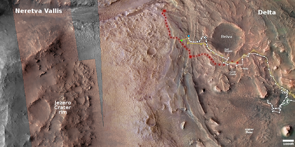
The Ingenuity engineering team today updated the helicopter’s flight log, showing that the 55th flight occurred on August 12, 2023, one day later than originally planned, and flew 881 feet for 143 seconds, 61 feet and 9 seconds longer than planned.

The overview map above shows the present locations of both Perseverance and Ingenuity. The green dot marks Ingenuity’s new position, while the blue dot marks where Perseverance presently sits in Jezero Crater. Based on this map, the main goal of the flight was apparently to fly Ingenuity over a route that Perseverance will likely use to return to its planned route, as indicated by the red dotted line.

0 comments
1 59 60 61 62 63 89