Residual ice on the shaded north-facing slope of northern Martian crater

Residual ice on Mars?
Click for original image.

Cool image time! The picture to the right, rotated, cropped, reduced, and sharpened to post here, was taken on April 10, 2023 by the high resolution camera on Mars Reconnaissance Orbiter (MRO). In the headline I am speculating a bit when I call that pile of material bunched up against the interior slope of this unnamed 18-mile-wide crater residual ice. No data is available to me that proves that assumption, but the look, the location, and the general previous data from Mars all tell me that this is what it is.

First, the location within the crater. Everyone who has lived in the northern latitudes where snow falls knows that snow will remain in the shaded slopes that face north — where less direct sunlight falls — much longer than in places where there is more sunlight. You can sometimes even find this residual snow as late as June and July in some such spots.

This phenomenon will be no different on Mars. In those alcoves this material, which looks exactly like glacial features found in many other places in the mid-latitudes of Mars (such as inside the small half-mile-wide crater in the lower left), is well protected, so that even when the rest of the ice sublimated away within the crater it remained. The cliff wall rises five hundred feet to the south, blocking sunlight so that for most of the year little directly sunlight touches this surface.
» Read more
0 comments

Chandrayaan-3 completes next-to-last orbital maneuver before releasing Vikram lander


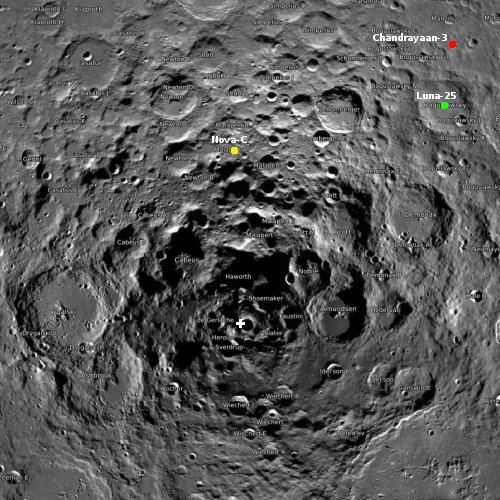
Click for interactive map.

According to India’s ISRO space agency, its Chandrayaan-3 spacecraft has successfully completed the next-to-last orbital maneuver burn before releasing Vikram lander, lowering the spacecraft’s orbit around the Moon to 150 by 177 kilometers.

Today’s maneuver can be considered the second last vital maneuver. The one that takes place on August 16, will set the course for the Vikram lander.

Based on how today’s and August 16’s manoeuvres are executed, ISRO will get to decide where the Vikram lander touches down, among three predesignated spots on the Moon’s surface.

It had been my understanding that the landing zone was as indicated by the red dot on the map to the right. It might be instead that was only one of three potential landing sites. If so, I will update the map when more data is released.

0 comments

The flat and mostly featureless flood lava plains of Mars

The flat and mostly featureless lava plains of Mars
Click for original image.

Cool image time! The picture to the right, rotated, cropped, reduced, and sharpened to post here, was taken on July 3, 2023 by the high resolution camera on Mars Reconnaissance Orbiter (MRO). Dubbed a “terrain sample” by the camera team, it was likely taken not as part of any scientist’s specific research program but to fill a gap in the camera’s schedule in order to maintain its proper temperature. When the camera team needs to do this they try to pick something of interest that is below during that gap.

In this case MRO was over the vast flood lava plains of Mars where for many hundreds of miles the only features are small variations produced from different overlapping lava flood events. The layers of lava in this region in fact appear so thick that there are relatively few places where the older topography still sticks up through the lava. In the case of this picture, the ridges might indicate such buried topography, but they also might simply be dikes of lava, pushed up through fissures from underground.
» Read more

0 comments

The icy mountains close to where SpaceX hopes to land Starship on Mars

The icy mountains near Starship's landing site on Mars
Click for original image.

Cool image time! The photo to the right, rotated, cropped, reduced, and sharpened to post here, was taken on June 25, 2023 by the high resolution camera on Mars Reconnaissance Orbiter (MRO). Labeled as showing “flow features” by the scientists, it gives us a nice example of many of the different types of glacial and near-surface ice features seen routinely in the Martian latitudes above 30 degrees, especially in the northern hemisphere.

First there is the apron around the mound. Its layering suggests the many cycles that Mars’ climate has undergone as its rotational tilt swung back and forth from as low as 11 to as much as 60 degrees (it is presently at 25 degrees).

The mound, with those two depressions at its peak, suggests the possibility that it is some form of ice/mud volcano, similar to the suspected ice/mud volcanoes routinely seen in the northern lowland plains of Utopia Basin.
» Read more

4 comments

Martian craters or volcanoes?

Martian craters or volcanoes?
Click for original image.

Cool image time! The picture to the right, cropped and reduced to post here, was taken on June 30, 2023 by the high resolution camera on Mars Reconnaissance Orbiter (MRO). The scientists label these features “cones” because many of the depressions sit on top of a mound or hill, suggesting some form of volcanic feature, either from erupting lava, ice, or mud.

Yet, are they volcanoes? Some or even many could instead be impact craters, created when a asteroid broke up during infall, creating a spray of bolides. Erosion of surrounding terrain can create what scientists call pedestal craters, but if all these craters were from an impact than all would either be pedestal craters, or not. Instead, we have a mix of some craters above and others level with the terrain.
» Read more

1 comment

Ingenuity completes 54th flight, a short hop after previous flight ended prematurely

Overview map
Click for interactive map.

According to the Ingenuity engineering team, Ingenuity has successfully completed its 54th flight on Mars, a short 25 second hop up and down that was done to try to figure out why the previous flight previous flight, #53, had ended prematurely.

Flight 53 was planned as a 136-second scouting flight dedicated to collecting imagery of the planet’s surface for the Perseverance Mars rover science team. The complicated flight profile included flying north 666 feet (203 meters) at an altitude of 16 feet (5 meters) and a speed of 5.6 mph (2.5 meters per second), then descending vertically to 8 feet (2.5 meters), where it would hover and obtain imagery of a rocky outcrop. Ingenuity would then climb straight up to 33 feet (10 meters) to allow its hazard divert system to initiate before descending vertically to touch down.

Instead, the helicopter executed the first half of its autonomous journey, flying north at an altitude of 16 feet (5 meters) for 466 feet (142 meters). Then a flight-contingency program was triggered, and Ingenuity automatically landed. The total flight time was 74 seconds.

This explains why, after the 53rd flight, the engineering team had not immediately added that flight to the helicopter’s flight log. That log is now updated to include both the 53rd and 54th flights, but the data from the 53rd flight was held back until after the 54th flight was completed.

The green dot in the overview map above shows Ingenuity’s present position, only a few feet to the west from its previous position shown here. The blue dot indicates Perseverance’s present position. The red dotted line indicates the planned route of the rover.

1 comment

Curiosity under the shadow of a Martian mountain

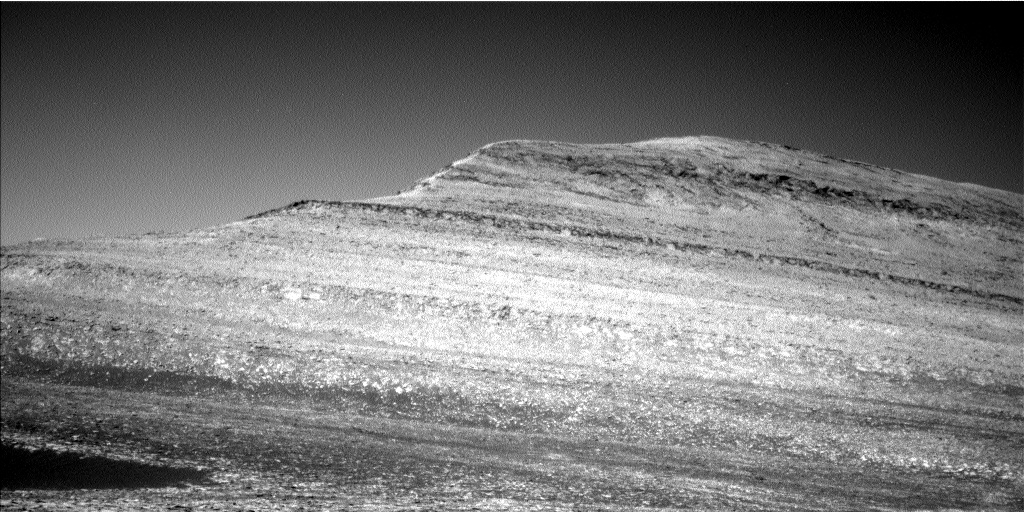
Panorama showing Kukenan on August 8, 2023
Click for full resolution. For original images, go here and here.

Overview map
Click for interactive map

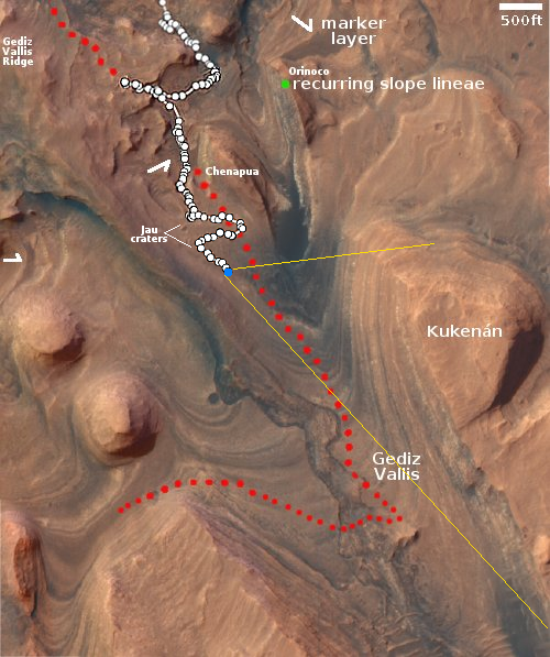
Another cool image to start the week! The panorama above was created using two navigation images taken by Curiosity on August 8, 2023. It looks almost due west at the dramatic western wall of 400-foot-high Kukenan butte.

The blue dot on the overview map to the right marks Curiosity’s present location. The yellow lines indicate approximately the area covered by the panorama above. The red dotted line indicates the rover’s planned route.

Recently JPL issued a press release touting the efforts of its engineers to overcome the very steep and rocky terrain that Curiosity is presently traversing, an effort that I have documented repeated in the past few months (see posts here and here). They had been trying to send Curiosity straight up the mountain, to no success, and finally decided to do what every hiker and trail-maker does routinely, do back and forth switchbacks to reduce the grade per step.

In June they headed slowly uphill going east. In July they turned back and worked their way uphill going west, heading back to the Jau crater complex to get a quick look at these craters, then turned again in August to head back east, slowly working uphill along the contour lines. As they do this the rover is moving closer and closer to Kukenan, the largest butte so far studied in the foothills of Mount Sharp.

This panorama is one of the best illustrations of the very complex geological history of Mars. Each layer signals a past cycle in Mars’ very cyclic history, created because of the red planet’s wide swings of rotational tilt over time. Once underground, these layers have become exposed because erosion over the eons has slowly removed the material that once buried it, leaving the butte behind.

0 comments

SpaceX conducts static fire test of Superheavy and its launchpad systems

SpaceX yesterday conducted a static fire test of Superheavy and its launchpad systems at Boca Chica.

After a couple of hours of chilling the fuel lines, filling of the liquid oxygen and liquid methane tanks aboard Booster 9 began at T-Minus 67 minutes. The liquid oxygen tank was fully filled with the liquid methane only partially filled with what was required for the test.

After a smooth countdown, Booster 9 lit all 33 Raptor engines, however, 4 shut down early during the 2.74-second duration test. The test was intended to last 5 seconds.

The new water deluge system seemed to work as intended, albeit with a very short firing of the engines. Instead of a giant dust cloud that is usually formed after a static fire test, this test created a steam cloud that dissipated fairly quickly following the test.

The premature shutdown and the even earlier shut down of four engines suggests SpaceX still has kinks it needs to work out. No surprise. It will now probably switch out those four engines, analyze the test, and do it again. It will do so partly because it needs to before the orbital test flight, and partly because it can’t do that test flight because the FAA has still not issued a launch license.

I have embedded the video of that test below the fold.
» Read more

3 comments

ISRO releases first images of the Moon from Chandrayaan-3

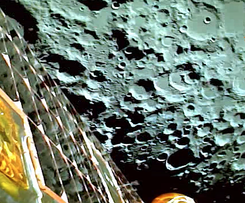
The Moon as seen by Chandrayaan-3

India’s space agency ISRO yesterday released the first images taken of the Moon by Chandrayaan-3, soon after entering lunar orbit.

The picture to the right is a screen capture from the short movie the agency compiled from those images, available at the link. The pictures were taken on August 5th, during the engine burn that put the spacecraft into lunar orbit. A solar panel can be seen on the left, with the cratered lunar surface to the right.

Chandrayaan-3 is presently undergoing a series of engine burns to lower its orbit in preparation for a planned August 23rd lunar landing in the high southern latitudes of the Moon.

0 comments

Chandrayaan-3 enters lunar orbit


Click for interactive map.

India’s Chandrayaan-3 spacecraft today successfully entered lunar orbit, where it will spend the next week or so slowly lowering its orbit in preparation for a landing attempt by its Vikram lander on August 23rd.

Chandrayaan-3 began a roughly 30-minute burn around 9:30 a.m. Eastern, seeing the spacecraft enter an elliptical lunar orbit, the Indian Space Research Organization (ISRO) stated via social media. “MOX, ISTRAC, this is Chandrayaan-3. I am feeling lunar gravity,” ISRO Tweeted. “A retro-burning at the Perilune was commanded from the Mission Operations Complex (MOX), ISTRAC, Bengaluru.”

The spacecraft will gradually alter its orbit with a burn to reduce apolune Sunday, Aug. 6. It will settle into a 100-kilometer-altitude, circular polar orbit on Aug. 17. From here, the Vikram lander will separate from the mission’s propulsion module and enter a 35 x 100-km orbit in preparation for landing.

If the landing attempt is successful, the Pragyam rover will roll off Vikram to operate for about two weeks on the lunar surface in the high southern latitudes of the Moon.

Meanwhile, the Russian lander Luna-25 will launch on August 10th. Since the rocket that launches it and engines it carries are larger than that used by Chandrayaan-3, it will likely land in Boguslawsky crater, before Vikram touches down nearby.

1 comment

A hiking paradise on Mars!

A hiking paradise on Mars
Click for original image.

Cool image time! The picture to the right, cropped, reduced, sharpened, and annotated to post here, was taken on May 21, 2023 by the high resolution camera on Mars Reconnaissance Orbiter (MRO). It shows one of Mars’ more impressive mountains with the Sun somewhat low in the western sky, resulting in the long dark shadows on the eastern slopes.

The line is my quick attempt to mark the obvious route that would be taken along that ridge line to get from the bottom to the top. This could be a hiking trail, or a road. In either case, the elevation gain from the bottom of the ridge to the plateau on top would be about 3,900 feet in about a mile and a half, very steep for Earth — at approximately a 26 degree grade — but probably quite doable in the one-third Martian gravity.

The lower end of my proposed route however is hardly the bottom of the mountain. The slope, now alluvial fill made up of dust and debris from above, continues downhill for another 5,400 feet. All told, from top to bottom the elevation gain is about 9,300 feet over 8.5 miles.
» Read more

4 comments

Scientists release infrared image of the Ring nebula, taken by Webb

The Ring Nebula, in false color by Webb
Click for original image.

Scientists yesterday released the first false-color infrared image of the Ring nebula taken by the Webb Telescope. That image, cropped to post here, is to the right. From the press release, which is heavy with platitudes but little information:

Approximately 2,600 lightyears away from Earth, the nebula was born from a dying star that expelled its outer layers into space. What makes these nebulae truly breath-taking is their variety of shapes and patterns, that often include delicate, glowing rings, expanding bubbles or intricate, wispy clouds. These patterns are the consequence of the complex interplay of different physical processes that are not well understood yet. Light from the hot central star now illuminates these layers.

Just like fireworks, different chemical elements in the nebula emit light of specific colours. This then results in exquisite and colourful objects, and furthermore allows astronomers to study the chemical evolution of these objects in detail.

It appears this image was produced using Webb’s near infrared instrument. Further data from its mid-infrared instrument has not yet been released. For a Hubble image of the Ring Nebula, in optical light that the human eye sees, go here.

1 comment
1 60 61 62 63 64 89