NASA agrees to let Axiom fly a fourth private manned mission to ISS

NASA and Axiom have now signed a new agreement allowing Axiom to fly a fourth private manned mission to ISS, tentatively scheduled for no earlier than August 2024.

Through the mission-specific order, Axiom Space is obtaining from NASA crew supplies, cargo delivery to space, storage, and in-orbit resources for daily use. The order also accommodates up to seven contingency days aboard the space station. This mission is subject to NASA’s pricing policy for the services that are above space station baseline capabilities.

The order also identifies capabilities NASA may obtain from Axiom Space, including the return of scientific samples that must be kept cold and other cargo, and the capability to use the private astronaut mission commander’s time to complete NASA science or perform tasks for the agency.

The company has already hired SpaceX to provide the transportation to and from ISS, using its Falcon 9 rocket and one of its fleet of four manned Dragon capsules.

1 comment

Despite good first images from Euclid, the orbiting telescope has a problem

Even though the first light images from Euclid have been sharp and exactly what astronomers want, the orbiting telescope designed to make a 3D map of billions of galaxies has an issue that will likely put some limits to that map.

When the telescope started booting up, ESA observers were concerned by the appearance of light markings on the first images relayed to Earth. This, it confirmed, was due to sunlight filtering into the telescope, “probably through a tiny gap”.

A correction to Euclid’s position was able to offset this issue. It means that while the ESA is confident Euclid will be fine to proceed with its mapping mission, particular orientations for the telescope may not be possible.

A limitation like this means that the telescope will not being able to look in some directions and get mapping images. Thus, the overall map will have gaps, though it appears at this moment that the scientists think those gaps will not seriously impact the telescope’s overall work. We shall see.

1 comment

The dry and mountainous terrain west of Jezero Crater

The dry and mountainous terrain west of Jezero Crater
Click for original image.

Since my earlier update today about Perseverance and Ingenuity mentioned the very diverse and strange geology known to exist west of Jezero Crater and where the rover is eventually headed, I thought it worthwhile to post another cool image of that terrain.

The picture to the right, rotated, cropped, reduced and sharpened to post here, was taken on May 22, 2023 by the high resolution camera on Mars Reconnaissance Orbiter (MRO). Labeled a “terrain sample” image, the location was likely chosen by the camera team in order to fill a gap in the camera’s schedule so that they can maintain its proper temperature. Having a gap that put the spacecraft over this region to the west of Jezero was however a great opportunity to get another look at this rocky, mountainous, and very parched terrain, located in Mars’ very dry equatorial regions.
» Read more

0 comments

Perseverance snaps new close-up of Ingenuity

Overview map
Click for interactive map.

Ingenuity as seen by Perseverance on August 2, 2023
Ingenuity as seen by Perseverance on August 2, 2023.
Click for original image.

Cool image time! With Perseverance and Ingenuity in the past week getting close together for the first time in months, the Perseverance team naturally turned its high resolution mast cameras at the helicopter. The picture to the right, cropped, reduced, and sharpened to post here, was taken on August 2, 2023 by the rover’s left mast camera, showing Ingenuity only about two hundred feet away.

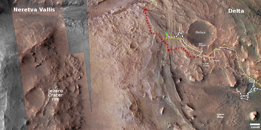
The blue dot on the overview map above shows Perseverance’s present location, with the green dot marking Ingenuity’s. The picture to the right is therefore looking almost due south. The red dotted line indicates the rover’s planned route, moving towards Neretva Vallis, the gap in the rim of Jezero Crater from which the delta had flowed, eons ago. The rover’s goal is to eventually enter that gap and explore the very diverse and strange geology known to exist outside the crater to the west.

We should also expect even better images of Ingenuity in the next week. Its 54th flight is scheduled for today, in which the engineering team wants to send the helicopter on a simple straight up and down hop of sixteen feet in order to better “localize” the helicopter. With Perseverance less than two hundred feet away, its cameras should be able to assemble a great movie of that flight.

1 comment

New software detects its first potentially dangerous asteroid

New software designed to detect asteroids, developed for use with the Rubin Observatory presently being built in Chile, has successfully discovered its first potentially hazardous asteroid (PHA) using data from another smaller operational ground-based telescope.

The discovered asteroid is 600 feet long, large enough to pose a real threat should it ever hit the Earth. Fortunately, the data says that though its orbit can take it as close as 140,000 miles there is no impact likely in the foreseeable future.

When the Rubin telescope begins its planned ten year survey of the entire night sky in 2025, this software is expected to almost triple the number of known potentially-hazardous-asteroids, from 2,350 to almost 6,000.

Funded primarily by the U.S. National Science Foundation and the U.S. Department of Energy, Rubin’s observations will dramatically increase the discovery rate of PHAs. Rubin will scan the sky unprecedentedly quickly with its 8.4-meter mirror and massive 3,200-megapixel camera, visiting spots on the sky twice per night rather than the four times needed by present telescopes. But with this novel observing “cadence,” researchers need a new type of discovery algorithm to reliably spot space rocks.

Thus, the development of this new software.

3 comments

The first glacial evidence found on Mars back in 2007

Glaciers on Mars?
Click for original image.

Cool image time! The picture to the right, cropped, reduced, sharpened, and annotated to post here, was taken on January 3, 2023 by the high resolution camera on Mars Reconnaissance Orbiter (MRO). It shows the eastern wall of what the scientists call a graben, a large depression caused when the ground inside the depression suddenly shifted downward.

The elevation difference between the high and low points is about 3,500 feet. The streaks on the lower half of the cliff wall are slope streaks, a phenomenon unique to Mars that remains at this moment unexplained. Though the streaks resemble avalanches, they do not change the topography in any way, have no debris pile at their base, and appear instead to be a stain that appears at random times of the year that fades with time.

What is intriguing about this picture however is the wavelike floor on its western half. At first glance these waves suggest some form of dust dunes or lava flows, but neither conclusion appears correct. Instead, we are looking at what was one of the first discoveries on Mars of what scientists have determined to be glacial features.
» Read more

0 comments

NASA detects weak signal from Voyager 2

Though communications with Voyager 2 have not been re-established, JPL engineers using NASA’s Deep Space Network of antennas have detected a weak signal from Voyager 2 that indicates the spacecraft is still functioning.

Using multiple antennas, NASA’s Deep Space Network (DSN) was able to detect a carrier signal from Voyager 2. A carrier signal is what the spacecraft uses to send data back to Earth. The signal is too faint for data to be extracted, but the detection confirms that the spacecraft is still operating. The spacecraft also continues on its expected trajectory. Although the mission expects the spacecraft to point its antenna at Earth in mid-October, the team will attempt to command Voyager sooner, while its antenna is still pointed away from Earth. To do this, a DSN antenna will be used to “shout” the command to Voyager to turn its antenna. This intermediary attempt may not work, in which case the team will wait for the spacecraft to automatically reset its orientation in October.

The hope is that new commands to re-orient, sent by the strongest signal possible, might be heard by the spacecraft, causing it to obey now. If not, this weak signal from Voyager 2 still suggests that the October reset will occur as normal and engineers will be able to recover communications then.

2 comments

The wind-scoured dusty and cratered dry tropics of Mars

The wind-scoured dusty and cratered dry tropics of Mars
Click for original image.

Cool image time! The picture to the right, cropped, reduced, and sharpened to post here, was taken on June 2, 2023 by the high resolution camera on Mars Reconnaissance Orbiter (MRO), and shows one small area in Martian equatorial regions where the main features are a dusty plain interspersed with craters, not entirely dissimilar to the Moon .

In the picture the northwest-to-southeast orientation of ridge-lines, plus the position of divots with their steep and deep end all on the northwest side, all suggest the prevailing winds here blow in the same direction, from the northwest to the southeast.

We are looking at a very ancient terrain. Many of these craters likely date from the early bombardment period of the solar system, just after the planets had formed but there was still a lot of objects around crashing into them.
» Read more

1 comment

Monitoring the gullies on Mars for changes

Monitoring the gullies on Mars
Click for original image.

Cool image time! The picture to the right, cropped and reduced to post here, was taken on March 24, 2023 by the high resolution camera on Mars Reconnaissance Orbiter (MRO) as part of a long term monitoring program of the many Martian gullies scientists have found above 30 degrees north latitude on a variety of slopes.

Martian gullies are small, incised networks of narrow channels and their associated downslope sediment deposits, found on the planet of Mars. They are named for their resemblance to terrestrial gullies. First discovered on images from Mars Global Surveyor, they occur on steep slopes, especially on the walls of craters. Usually, each gully has a dendritic alcove at its head, a fan-shaped apron at its base, and a single thread of incised channel linking the two, giving the whole gully an hourglass shape. They are estimated to be relatively young because they have few, if any craters.

…Most gullies occur 30 degrees poleward in each hemisphere, with greater numbers in the southern hemisphere. Some studies have found that gullies occur on slopes that face all directions; others have found that the greater number of gullies are found on poleward facing slopes, especially from 30° to 44° S. Although thousands have been found, they appear to be restricted to only certain areas of the planet. In the northern hemisphere, they have been found in Arcadia Planitia, Tempe Terra, Acidalia Planitia, and Utopia Planitia. In the south, high concentrations are found on the northern edge of Argyre basin, in northern Noachis Terra, and along the walls of the Hellas outflow channels.

Orbital data has identified almost 5,000 gullies on Mars. Based on their shape and the Martian climate, scientists generally think these gullies were formed by some form of water flow, possibly coming from an underground aquifer at their top.
» Read more

1 comment

Euclid’s first images look good

Scientists have determined that the first test images from the two cameras on the recently launched orbiting Euclid space telescope are sharp and as expected.

Both VIS and NISP provided these unprocessed raw images. Compared to commercial products, the cameras are immensely more complex. VIS comprises 36 individual CCDs with a total of 609 megapixels and produces high-resolution images of billions of galaxies in visible light. This is how astronomers determine their shape. The first images already give an impression of the abundance that the data will provide.

NISP’s detector consists of 16 chips with a total of 64 megapixels. It operates in the near-infrared at wavelengths between 1 and 2 microns. In addition, NISP serves as a spectrograph, which splits the light of the captured objects similar to a rainbow and allows for a finer analysis. These data will allow the mapping of the three-dimensional distribution of galaxies.

Knowing that 3D distribution will allow scientists to better determine the nature of both dark energy (related to the acceleration of the universe’s expansion) and dark matter (related to an undiscovered mass that affects the formation and shape of galaxies).

1 comment

Meandering ridge exiting glacier on Mars

Overview map

Meandering ridge exiting glacier on Mars
Click for original image.

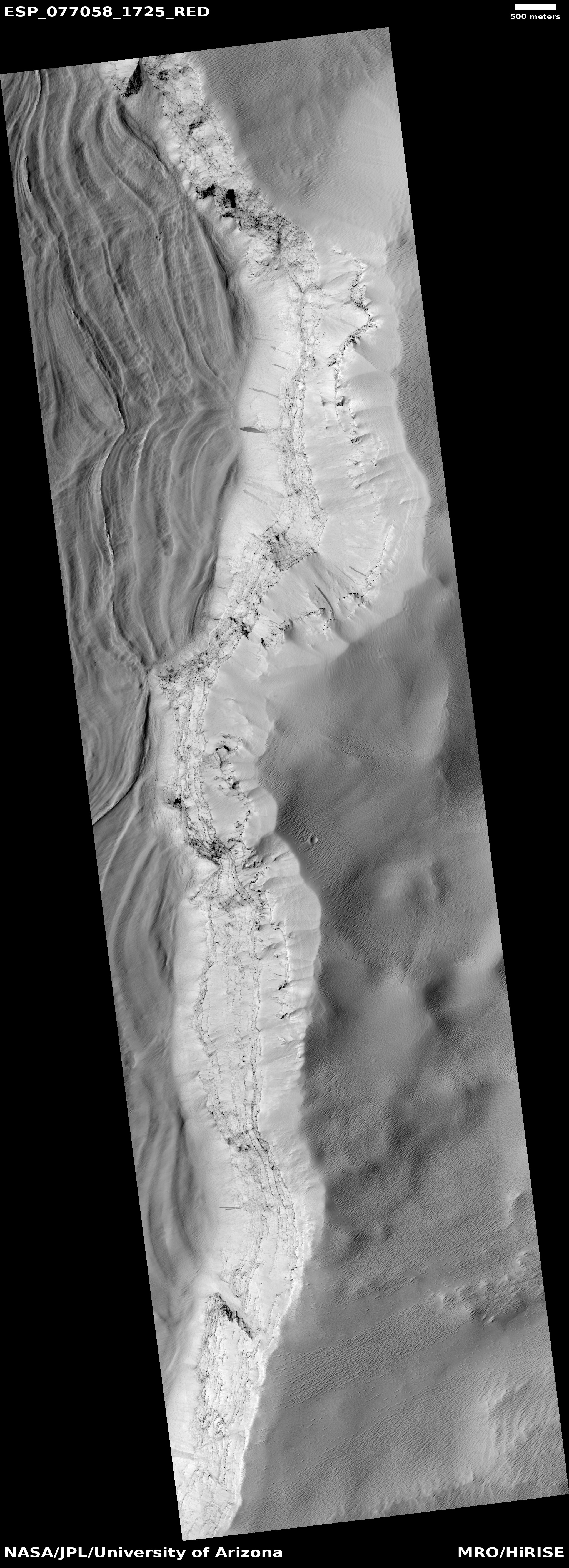
Today’s cool image illustrates the complex explanations scientists sometimes have to come up with explain the strange geology seen on Mars. The picture to the right, cropped, reduced, and sharpened to post here, was taken on May 30, 2023 by the high resolution camera on Mars Reconnaissance Orbiter (MRO). It shows what the scientists label as a whitish “ridged flow-like feature” that appears to exit out of the massive hill to the west.

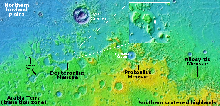
The white dot on the overview map above as well as in the inset marks this location, smack dab inside the 2,000-mile-long strip of glacier country in the Martian northern mid-latitudes. As you can see from the inset, that massive hill is actual the foot of a large apron of material, likely ice-infused, that has sagged down from the large 5,400-foot high mesa to the west.

The white material is likely what the scientists call an inverted river. Once it was a channel in which either water or ice flowed. With time the weight of that material compacted the riverbed so that it was denser than the surrounding terrain, much of which was likely soft anyway because of a high ice content. When that surrounding terrain eroded away, the riverbed resisted that erosion, and instead became the raised ridge we now see.

0 comments

Contact lost with Voyager 2, hopefully temporarily

New but planned commands to Voyager 2, presently flying beyond the solar system, caused the spacecraft to point its antenna incorrectly so that communications with Earth have been lost.

A series of planned commands sent to NASA’s Voyager 2 spacecraft on July 21 inadvertently caused the antenna to point 2 degrees away from Earth. As a result, Voyager 2 is currently unable to receive commands or transmit data back to Earth.

Voyager 2 is located almost 12.4 billion miles (19.9 billion kilometers) from Earth and this change has interrupted communication between Voyager 2 and the ground antennas of the Deep Space Network (DSN). Data being sent by the spacecraft is no longer reaching the DSN, and the spacecraft is not receiving commands from ground controllers.

The spacecraft is also programmed to periodically reset its orientation so that its antenna points to Earth, with the next reset scheduled for October 15th. Engineers hope that at that point contact will be recovered.

If not, this incident will mark the end of the mission, which launched in 1977 and has been functioning for 46 years as it has made close fly-bys of Jupiter, Saturn, Uranus, and Neptune, and then eventually entering interstellar space.

4 comments
1 61 62 63 64 65 89