More direct images released of exoplanet 87.5 light years away
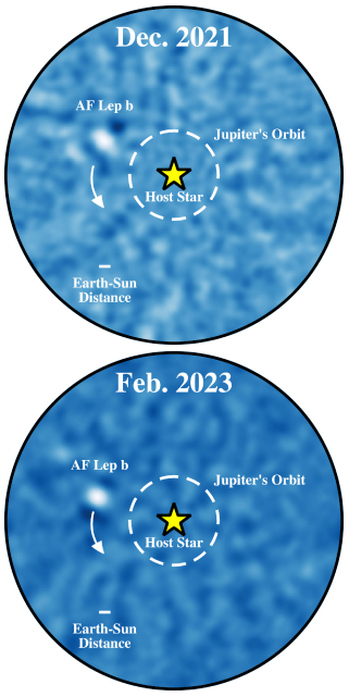
Keck images of exoplanet over time

The Keck Observatory in Hawaii has now released its own image of the exoplanet AF Leporis b, following up the images produced by the Very Large Telescope (VLT) released in February.

The direct images Franson’s team captured revealed that AF Lep b is about three times the mass of Jupiter and orbits AF Leporis, a young Sun-like star about 87.5 light-years away. They took a series of deep images of the planet starting in December 2021; two other teams also captured images of the same planet since then.

What make the Keck observations most interesting is that they captured over time the motion of the exoplanet as it orbited its star. The two images to the right show this motion.

The paper, available here, was published today in Astrophysical Journal Letters. This particular star also has a debris disk surrounding it, suggesting it is a young solar system still in the process of forming. From the paper’s conclusion:

AF Lep joins other young planet hosts with debris disks such as β Pic, HR 8799, HD 206893, and HD 95086, reinforcing indications of a higher frequency of long-period planets orbiting stars hosting debris disks.

0 comments

A lava flow on a Martian lava plain

A lava flow on a Martian lava plain
Click for original image.

While much of surface of the Martian equatorial regions is comprised of volcanic flood lava, the place where it is most obvious and evident is on the flanks of the three giant volcanoes of the Tharsis Bulge. Here, lava did not simple spout from surface vents to flood low-lying large areas, filling those depressions quickly almost like water. Instead it issued from vents on the slopes of those mountains, or from their calderas at their peaks, and flowed downhill almost like tsunamis of magma.

The picture to the right, rotated, cropped, reduced, and sharpened to post here, is a great example. Taken on March 11, 2023 by the high resolution camera on Mars Reconnaissance Orbiter (MRO), it shows the foot of one such flow, frozen in place as it oozed down hill from the Arsia Mons, about 300 miles away to the northwest.
» Read more

0 comments

BepiColumbo completes third Mercury flyby

Mercury as seen by BepiColumbo
Click for original image.

On June 19, 2023, the European Mercury orbiter BepiColumbo made the third of six planned flybys of Mercury on its way to orbit around that planet in 2025.

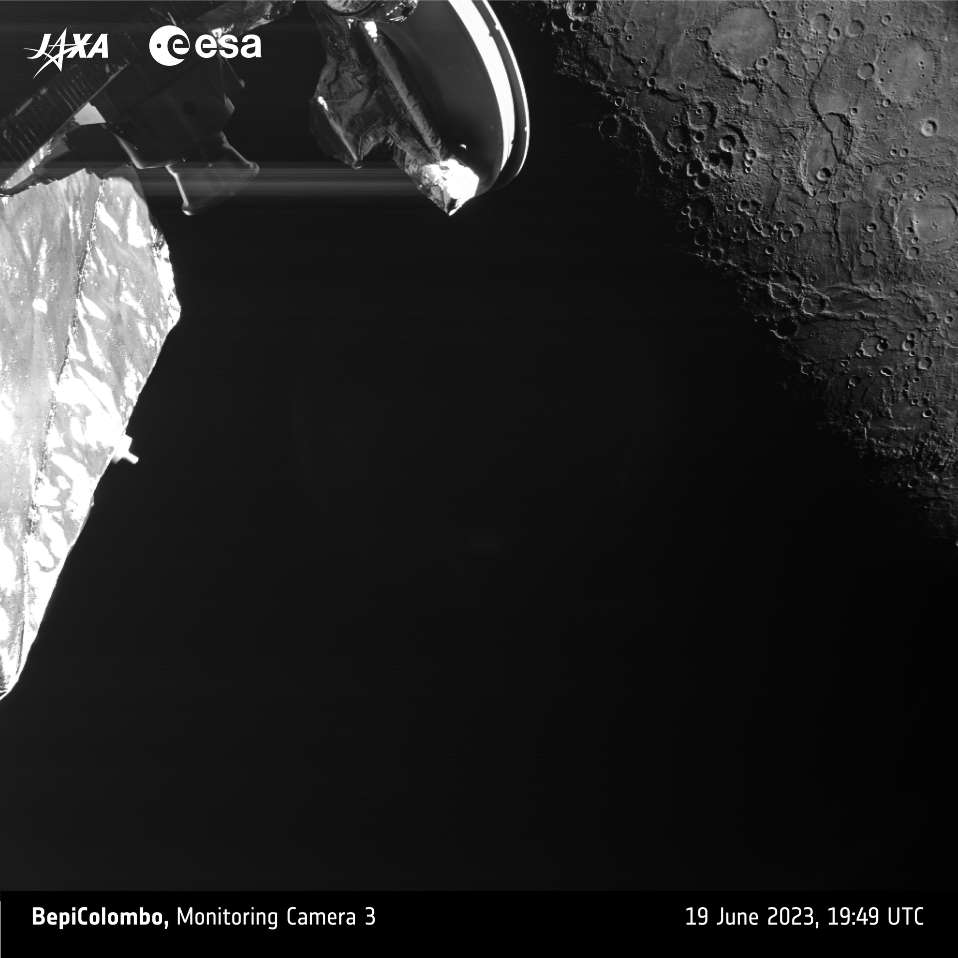
The closest approach was only 146 miles above the planet’s surface. Though no pictures were taken at that point because it was Mercury’s night side, as the spacecraft moved away it used one of its monitoring cameras, designed primarily to monitor the spacecraft itself, to look back at the planet. The picture to the right, cropped, reduced, and sharpened to post here, is one of the first taken. From its caption:

The image was taken at 19:49 UTC (21:49 CEST) by the Mercury Transfer Module’s monitoring camera 3, when the spacecraft was about 2536 km from the planet’s surface. Closest approach took place at 19:34 UT (21:34 CEST) on the night side of the planet at about 236 km altitude. The back of the Mercury Planetary Orbiter’s high-gain antenna and part of the spacecraft’s body is also visible in front of Mercury in this image.

Despite the dark nature of the image, several interesting geological features are seen in beautiful detail. Of particular interest is Beagle Rupes, a 600 km-long scarp that snakes over the surface. In this view it is seen cutting through a distinctive elongated crater named Sveinsdóttir, which likely got its shape from an impactor striking the surface at an angle.

The next flyby will occur on September 5, 2024.

1 comment

Looking down a canyon on Mars

Looking down a canyon on Mars
Click for original image.

Cool image time! The picture to the right was taken on June 17, 2023 by Curiosity’s high resolution camera, looking back down Gediz Vallis and out across the distant floor of Gale Crater, far below. The white dotted line shows the route within this image where Curiosity had previously traveled inside this canyon, coming up around that shadowed mesa and then off to the west to try to get to terrain that it had earlier retreated because it was too rough on the rover’s wheels. Its subsequent path to the spot where this picture was taken was off to the left of the image, out of view.

This picture illustrates well the steepness and roughness of the mountainous canyon through which Curiosity presently travels. The small mountains visible on the floor of Gale Crater, about sixteen miles away, are no more than 450 feet high. The floor of the crater is 1,900 feet below where Curiosity present sits.
» Read more

7 comments

A Martian crater with a wake of lava

Overview map

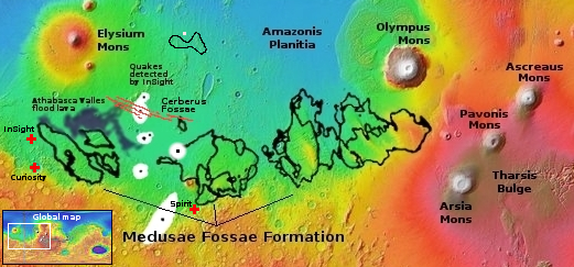
Cool image time! Today’s cool image begins with the overview map to the right. The white dot marks its location, on the western edge of Amazonis Planitia and about 1,000 miles east of the giant shield volcano Elysium Mons.

This is a region of numerous flood lava events that appear to cover the knobby mountainous terrain that was once here. We know that past terrain was knobby because in the black outline just south of this picture the knobs are everywhere, short peaks sticking up from a very flat flood lava plain. The region is also on the northern edge of the dry equatorial regions of Mars, at 27 degrees north latitude. It is likely there is little near surface ice here.

These details will help explain the cool image itself.
» Read more

0 comments

The icy mesas of Mars’ glacier country

Overview map

The ice mesas of Mars' glacier country
Click for original image.

Cool image time! The picture to the right, rotated, cropped, and reduced to post here, was taken on March 25, 2023 by the high resolution camera on Mars Reconnaissance Orbiter (MRO). The science team labeled this image “Cross-Section of Glacier-Like Form,” probably because the mesa in the center of the picture clearly shows numerous layers as you descend from its peak to the surrounding plains, an elevation difference of about 200 feet.

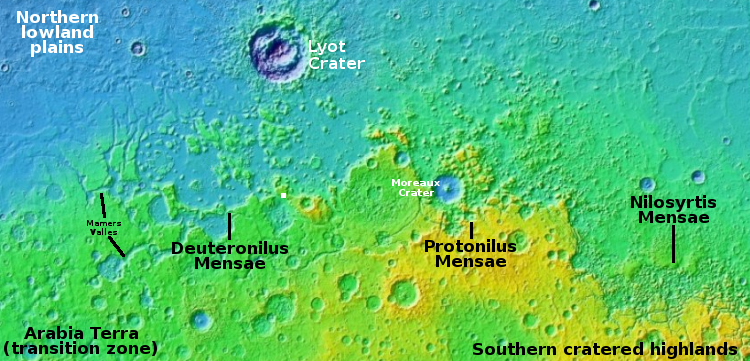
The white dot about 250 miles due south of Lyot Crater on the overview map above marks the location of this mesa, inside the chaos terrain of Deuteronilus Mensae that is the western section of the 2,000 long strip in the northern mid-latitudes of Mars that I call glacier country, since practically every image, like today’s, suggests the presence of glaciers.

The oblique mosaic below, created using MRO’s context camera images, illustrates this fact even more spectacularly.
» Read more

0 comments

Lightning on Jupiter

Lightning on Jupiter
Click for original image.

Cool image time! The picture to the right, cropped and reduced to post here, was taken on December 30, 2020 by Juno during its 31st close fly-by of Jupiter, and was enhanced and processed by citizen-scientist Kevin Gill.

In this view of a vortex near Jupiter’s north pole, NASA’s Juno mission observed the glow from a bolt of lightning. On Earth, lightning bolts originate from water clouds, and happen most frequently near the equator, while on Jupiter lightning likely also occurs in clouds containing an ammonia-water solution, and can be seen most often near the poles.

Juno was about 20,000 miles above Jupiter’s clouds when it took this picture, located at about 78 degrees north latitude.

4 comments

Drainage channel between two Martian hollows

Drainage channel between two Martian hollows
Click for original image.

Cool image time! The picture to the right, cropped, reduced, and sharpened to post here, was taken on April 28, 2023 by the high resolution camera on Mars Reconnaissance Orbiter (MRO). Dubbed a “terrain sample” by the camera team, it was likely taken not as part of any specific research project but to fill a gap in the camera’s schedule so as to maintain that camera’s proper temperature. When they have to do this, they try to pick interesting targets, though there is no guarantee the result will be very interesting.

In this case the camera snapped what appears to be a drainage channel between two deeper hollows. The channel sits about 100 feet above the western hollow and 260 feet above the eastern hollow. This makes some sense, as the overall drainage in this region is going from the west to the east, and then to the north.
» Read more

0 comments

Astronomers detect vaporized elements in atmosphere of hot Jupiter-sized exoplanet

Using the Gemini telescope in Hawaii, astronomers have detected several elements in atmosphere of hot Jupiter-sized exoplanet, dubbed WASP-76b, that would normally be found in rocks, but here are vaporized because the exoplanet orbits so close to its star.

In 2020 and 2021, using Gemini North’s MAROON-X (a new instrument specially designed to detect and study exoplanets), Pelletier and his team observed the planet as it passed in front of its host star on three separate occasions. These new observations uncovered a number of rock-forming elements in the atmosphere of WASP-76b, including sodium, potassium, lithium, nickel, manganese, chromium, magnesium, vanadium, barium, calcium, and, as previously detected, iron.

Due to the extreme temperatures of WASP-76b’s atmosphere, the elements detected by the researchers, which would normally form rocks here on Earth, are instead vaporized and thus present in the atmosphere in their gaseous forms. While these elements contribute to the composition of gas giants in our Solar System, those planets are too cold for the elements to vaporize into the atmosphere making them virtually undetectable.

The data not only suggests such elements exist in the solar system’s gas giants, but that such elements are common in solar systems elsewhere. That possibility increases the chances of other planets like Earth, capable of sustaining life as we know it, in addition to sustaining life as we don’t know it.

2 comments

BepiColumbo about to do third Mercury flyby

In its long journey to get into orbit around Mercury, BepiColumbo needs to do nine different flybys of the inner planets, with third fly-by of Mercury coming up on June 19, 2023.

The mission launched into space on an Ariane 5 from Europe’s Spaceport in Kourou in October 2018 and is making use of nine planetary flybys: one at Earth, two at Venus, and six at Mercury, to help steer into Mercury orbit.

After this flyby, the mission will enter a very challenging part of its journey to Mercury, gradually increasing the use of solar electric propulsion through additional propulsion periods called ‘thrust arcs’ to continually brake against the enormous gravitational pull of the Sun. These thrust arcs can last from a few days up to two months, with the longer arcs interrupted periodically for navigation and manoeuvre optimisation.

The spacecraft will zip past Mercury at a height of 147 miles. If all goes well, this dual orbiter mission, carrying both a European and a Japanese orbiter will arrive in 2025, beginning a planned three year mission in different complementary orbits.

5 comments

Rimstone dams in Mars’ youngest lava deposit

Rimstone dams in Mars' youngest lava deposit
Click for original image.

Cool image time! The picture to the right, rotated, cropped, reduced, and sharpened to post here, was taken on April 23, 2023 by the high resolution camera on Mars Reconnaissance Orbiter (MRO).

The scientists dub the features here merely as “land forms,” probably because it is difficult to explain the origins of many of these strange features. For example, why is the half-mile-wide crater filled that knobby terrain, far different than the surrounding plains? Similarly, what caused the small meandering ridges (less than five feet high) that appear to closely resemble the cave formation called rimstone dams?

And why is this terrain so generally flat and smooth?

As usual, the overview map helps explains some of this, but not all.
» Read more

0 comments

Eroding glacier on Martian slope?

Eroding glacier on Martian slope?
Click for original image.

Cool image time! The picture to the right, enhanced, cropped, reduced, and sharpened to post here, was taken on April 1, 2023 by the high resolution camera on Mars Reconnaissance Orbiter (MRO). It shows what the science team labels as “Rough Ground and Bright Exposures” on the flanks of a wide mountain range on Mars, whose highest point is about 4,400 feet higher to the northeast and about 30 miles away.

The arrow indicates the downhill grade. Notice the smooth flat areas that seem to only partially cover much rougher terrain below. To my eye this top layer resembles an Earth glacier that has partly sublimated or melted away, exposing the rougher bedrock below that has been ground and scraped by the glacier previously.

However, this is not on Earth, so assuming it is like an Earth glacier is dangerous.
» Read more

0 comments
1 66 67 68 69 70 89