A Martian crater with a very weird rim

A Martian crater with a very weird rim
Click for original image.

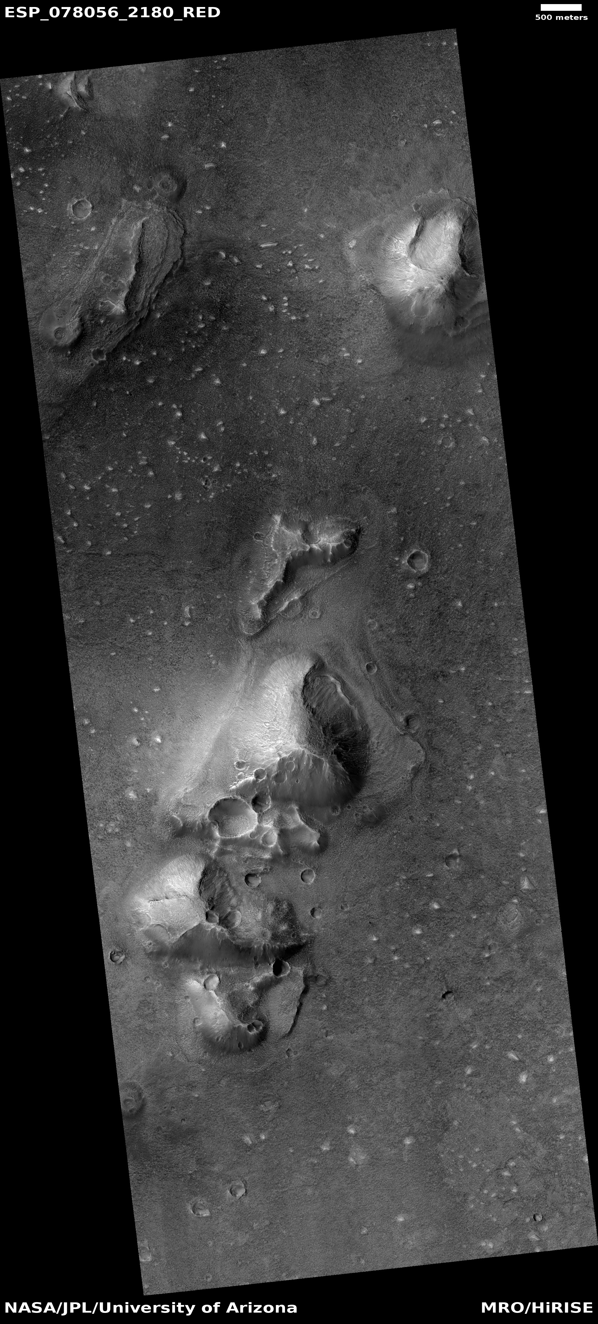
In looking through new images from Mars Reconnaissance Orbiter (MRO), I sometimes stumble some very strange things, with today’s cool image an example. The picture to the right, rotated, cropped, and reduced to post here, was taken on May 7, 2023 by MRO’s high resolution camera, and shows the western half of a two-mile-wide crater with a very weird rim, almost as if a person had decided he wanted to reshape it with a filigree pattern.

Though only two-miles wide, this crater actually has been named Johnstown. I suspect this is because of its strange rim, prompting a research effort and the need to provide it a name. Why the rim has this repeating pattern of gaps, however, is beyond my pay grade to explain, and I have been unable to track down any research papers about it. The nearby surrounding surface suggests vaguely the possibility that this is a caldera, not an impact crater, but even so why would the rim of the caldera have these regular breaks?
» Read more
1 comment

Zhurong found Mars drier than expected and less eroded than the Moon

According to a new paper, Chinese scientists using data from their Zhurong Mars rover have found little or no evidence of water in the immediate underground, while also finding the surface less eroded than the surface on the Moon.

A layer of regolith covers the surface of Mars, which is the result of geologic processes that occurred over millions to billions of years. Compared to the observations from satellites, the Zhurong rover of China’s first Mars mission (Tianwen-1) had a closer look at the properties of the regolith layer in the explored region within southern Utopia Planitia. There is evidence that the exposed materials might be related to aqueous activities. Local landforms on the surface suggest the possible presence of buried volatiles, like water ice. The radar instrument (RoPeR) on board the rover can expose subsurface structures and the dielectric properties of the regolith layer at high-resolution, to assess their composition. The loss tangent results suggest that water ice is not the main component of the local martian regolith at some depth. The scattering distribution of radar profile along the traveling path and heterogeneous subsurface features show more diverse surface processes and weaker space weathering effects on Mars than those on the airless Moon.

Since Zhurong landed in the equatorial regions, its data about the lack of water simply confirmed other data from orbit and from other rovers/landers. Though there are features even here that suggest the presence of water, that water made those features a long time ago, and is now gone.

The data suggesting the regolith is less eroded than the Moon, however, is a surprise, and counter-intuitive.

4 comments

The inconceivable scale of Mars’ canyons

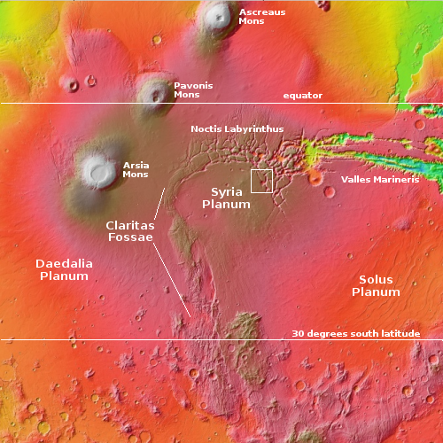
Overview map

Today’s cool image takes us to one of Mars’ biggest canyon systems that while linked to Valles Marineris, the biggest Martian canyon of them all, is considered a separate canyon system because it is made up of a labyrinth of criss-crossing canyons instead of a single major canyon line.

In fact, its name is Noctis Labyrinthus, as shown on the overview map to the right. In many ways its complex pattern is reminiscent of the chaos terrain seen mostly in Mars’ mid-latitudes, but there are major differences. The rectangle marks the area we shall zoom into below to show these differences as well as to feebly illustrate the grand scale of these canyons.

First, the formation of these canyons is closely linked to the volcanic events that formed the three giant volcanoes to the west. They are also strongly linked (in ways not yet fully understood) with the suspected catastrophic floods that drained from Noctis, through Valles Marineris, and out into the northern lowland plains to the east, eons ago when this dry equatorial region could have been wet.
» Read more

4 comments

Puzzling crater on alien Mars

Puzzling crater on alien Mars
Click for original image.

Today’s cool image once again illustrates that the things that orbiters photograph on the Martian surface are not always what they seem at first glance. The picture to the right, cropped, reduced, and sharpened to post here, was taken on March 23, 2023 by the high resolution camera on Mars Reconnaissance Orbiter (MRO). It shows what the scientists label as “layering” in this small mile-wide crater.

That layering, seen on both the interior and exterior slopes of its circular rim, is what makes this crater puzzling. It suggests this crater was not formed by an impact, but by volcanism. The layers suggest repeated eruptive events. That the crater sits above the surround plain by about 100 feet strengthens this conclusion.

And yet, a look at the overview map below suggests this conclusion is premature.
» Read more

1 comment

Swirls draining into a Martian crater

Swirls draining into a Martian crater
Click for original image.

Cool image time! The picture to the right, rotated, cropped, reduced, sharpened, and annotated to post here, was taken on April 8, 2023 by the high resolution camera on Mars Reconnaissance Orbiter (MRO).

The picture shows a terrain of swirls and terraced mesas. Because the shadows are deceptive, I have annotated the picture to show the actual drainage pattern of those swirls, suggesting that whatever material forms these swirls is not only draining about 200-250 feet down into the low point at the picture’s center, the swirls are also draining toward the small 1,000-foot-wide crater in the upper left. That crater however appears to lie on top of the swirls, which means it came after them.

What are the swirls made of?
» Read more

0 comments

Alien Mars

Alien Mars
Click for original image.

Today’s cool image illustrates again the alien geology of Mars, often disguised as geological features that at first glance seem familiar. The picture to the right, cropped and reduced to post here, was taken on April 9, 2023 by the high resolution camera on Mars Reconnaissance Orbiter (MRO). Its most distinct feature, the mile-wide double crater in the center bottom, at first appears typical of such craters found on the Moon and elsewhere, suggesting that the bolide that caused it broke in two as it cut through the Martian atmosphere.

This double crater however is not like lunar double craters, in that the shape of both craters is deformed, and the deformation is not quite the same in each. Moreover, the crater does not appear to have an upraised rim or to have thrown out any obvious ejecta. Instead, the two objects hit what looks like soft ground, such as when you drop a pebble into snow.

There’s more.
» Read more

0 comments

Curiosity’s most damaged wheel appears to be surviving the rough terrain on Mount Sharp

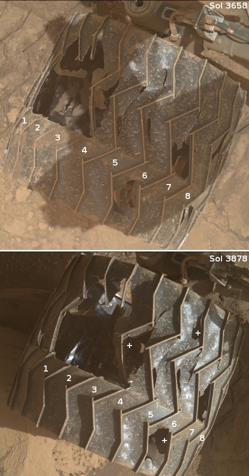
Curiosity's middle left wheel, from November 2022 to July 2023
For original images go here and here.

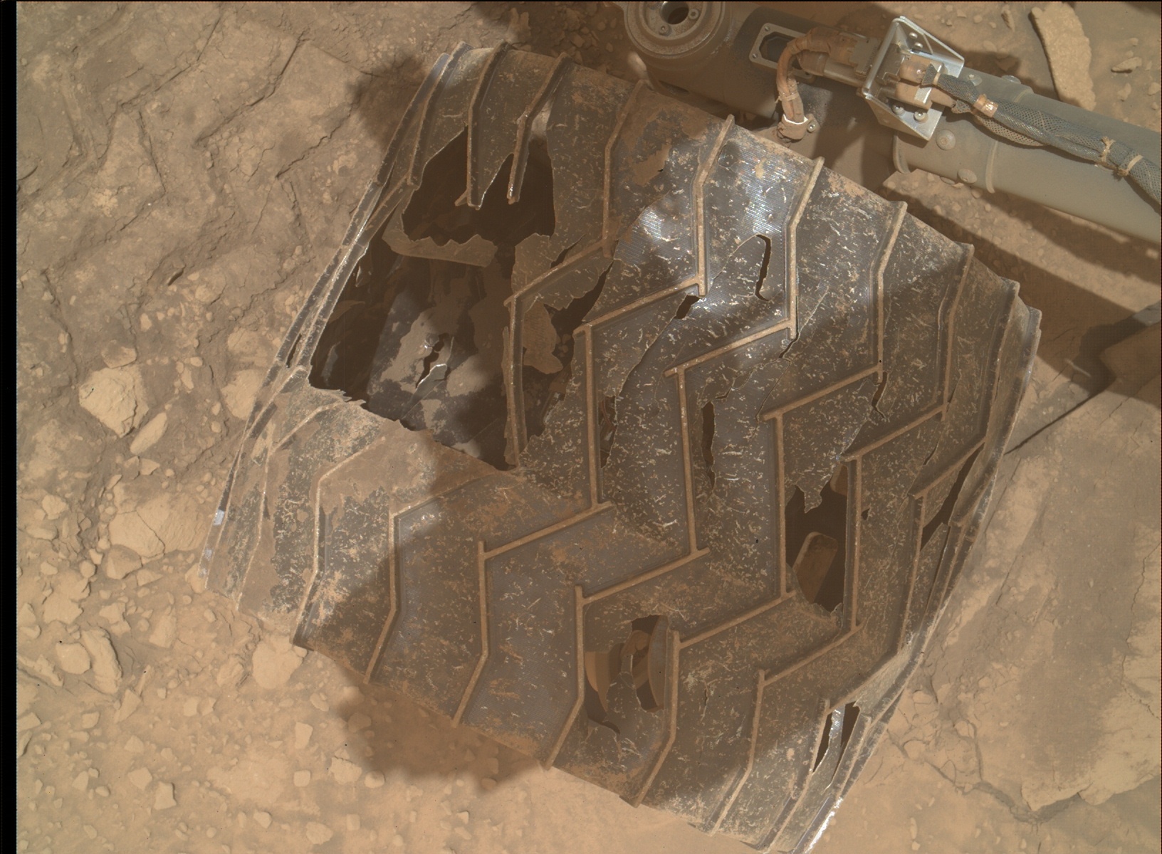
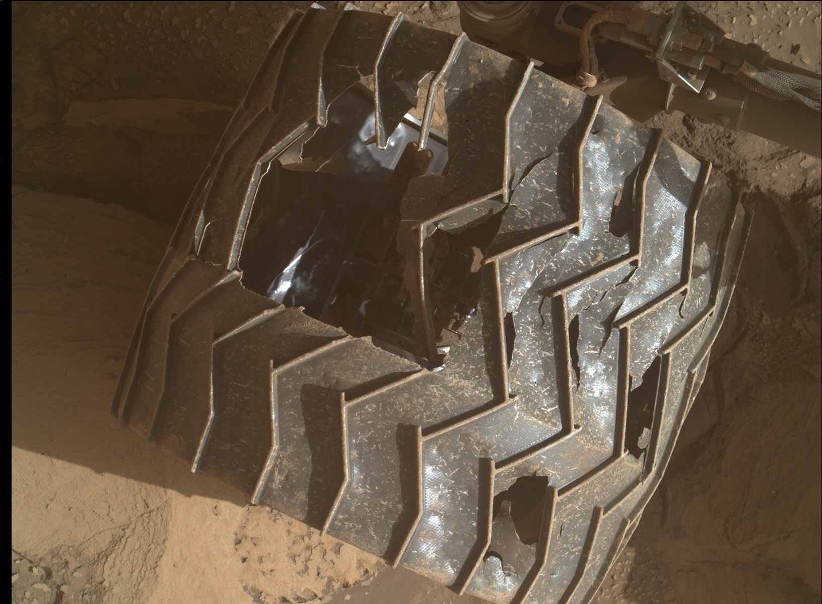
In today’s download of images from Curiosity was a set of pictures taken by its Mars Hand Lens Imager (MAHLI) of the rover’s wheels, as part of the science team’s routine inspection procedures after every 500 meters of travel.

The picture to the right shows what I think is the rover’s left middle wheel, its most heavily damaged, comparing what that wheel looks like now versus what it looked like in November 2022. At that time five of the wheel’s zig-zag grouser treads were broken, three of which are visible in both pictures. The numbers indicate identical wheel treads.

As you can see, after more than seven months of travel across some of the roughest and rockiest ground so far seen on Mars, no more grousers have broken in the new picture. The plus (“+”) signs indicate places where I think some additional metal between the grousers appears to have broken away, but even here the additional damage appears minimal.

Based on past wheel inspections, I expect more images will be taken in the next day or so. We shall see if those pictures indicate any further damage elsewhere. Based on this new picture, however, it appears that the care the science team takes in picking Curiosity’s route, as well as its software (designed to avoid the worst terrain), is continuing to preserve the wheels from further significant damage.

2 comments

A Martian volcanic ash field covering an ancient lava flow

A Martian volcanic ash field covering an ancient lava flow
Click for original image.

Cool image time! The picture to the right, rotated, cropped, reduced, and sharpened to post here, was taken on April 16, 2023 by the high resolution camera on Mars Reconnaissance Orbiter (MRO). It shows in the center an ancient tongue of lava flow that is surrounded by thick dust fields on the north and the south.

The arrow indicates the downhill grade. It also shows the direction of the prevailing winds, downhill to sculpt the volcanic ash into long streamers of parallel grooves, with obvious eddies forming around bits of older lava that still stick up through the ash. On the lava flow can also be seen one small volcano cone, on the picture’s right edge, suggesting that either during this flow or after it hardened magma bubbled up from below.

The location is fascinating, and in fact puts this picture into its much more spectacular context.
» Read more

0 comments

A spiral galaxy as seen by Hubble

A spiral galaxy as seen by Hubble
Click for original image.

Cool image time! The picture to the right, cropped, reduced, and sharpened to post here, was taken as part of a research project to use the Hubble Space Telescope to photograph galaxies where supernovae had recently occurred. From the caption:

UGC 11860 lies around 184 million light-years away in the constellation Pegasus, and its untroubled appearance can be deceiving; this galaxy recently played host to an almost unimaginably energetic stellar explosion.

A supernova explosion β€” the catastrophically violent end of a massive star’s life β€” was detected in UGC 11860 in 2014 by a robotic telescope dedicated to scouring the skies for transient astronomical phenomena; astronomical objects which are only visible for a short period of time. Two different teams of astronomers used Hubble’s Wide Field Camera 3 to search through the aftermath and unpick the lingering remnants of this vast cosmic explosion.

This Hubble image once again illustrates the vastness of the universe. Note that every single dot surrounding UGC 11860 in this picture is another far more distant galaxy. As much as UGC 11860 is in our local intergalactic neighborhood, it is still so distant that this field of view is small enough that it contains no stars.

2 comments

Ingenuity responds after 63 days of silence

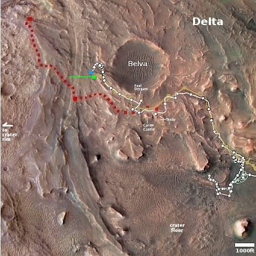
Overview map
Click for interactive map.

For the past two months the science and engineering teams for the Perseverance rover and the Ingenuity helicopter in Jezero Crater have been very silent as to the status of Ingenuity. On April 25, 2023 the Ingenuity team had posted their flight plan for the helicopter’s 52nd flight, with an expected flight date the next day.

Until today, however, no information about the results of that flight had been released. Except for one update in late May describing earlier issues with communications after flight 49, the science and engineering teams maintained radio silence about that 52nd flight in April.

Today’s update finally explained that silence:

The flight took place back on April 26, but mission controllers at NASA’s Jet Propulsion Laboratory in Southern California lost contact with the helicopter as it descended toward the surface for landing.

The Ingenuity team expected the communications dropout because a hill stood between the helicopter’s landing location and the Perseverance rover’s position, blocking communication between the two. The rover acts as a radio relay between the helicopter and mission controllers at JPL. In anticipation of this loss of communications, the Ingenuity team had already developed re-contact plans for when the rover would drive back within range. Contact was re-established June 28 when Perseverance crested the hill and could see Ingenuity again.

The flight plan for the 52nd flight in April had been to fly 1,191 feet to the west. Though the Ingenuity team has not yet released the actual flight details, I have indicated with the green line on the overview map above the estimated distance and direction planned. The green dot marks Ingenuity’s position before the flight, with the blue dot marking Perseverance’s present location. The red dotted line indicates the planned route for Perseverance.

11 comments

Another layered mesa in the Cydonia region of Mars

Another layered mesa in the Cydonia region of Mars
Click for original image.

Cool image time! The picture to the right, cropped, reduced, and sharpened to post here, was taken on March 22, 2023, and shows a 100-foot-high many-layered mesa in the Cydonia region of Mars.

The shadows in this picture are deceptive. The mesa’s high point is not the narrow ridge-line, but at the green dot just beyond that ridge’s northern terminus. In fact, if you were walking south from that dot and then along the crest of that ridge you would be walking downhill the entire length.

Cydonia is in the Martian northern lowland plains, in the mid-latitudes. Thus, there are many features in this picture suggesting near surface ice, such as the mounds with craters at their peak. All could be mud volcanoes as seen in many places in the northern lowland plains.
» Read more

1 comment

Curiosity tops a ridge to see its rough path forward

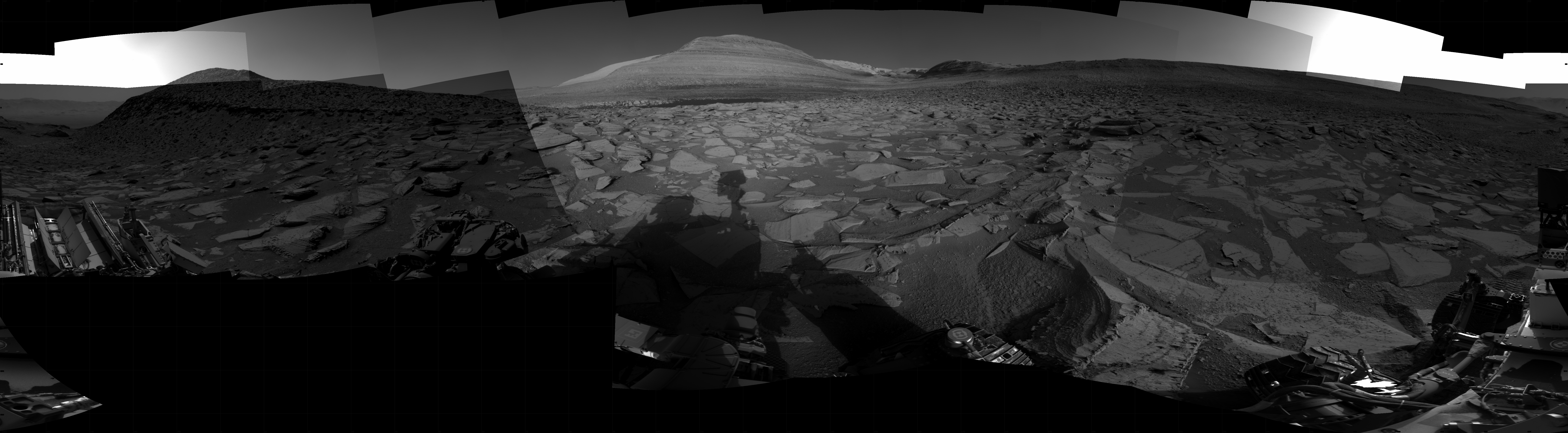
Curiosity's view ahead on June 29, 2023
Click for original image.

Overview map
Click for interactive map

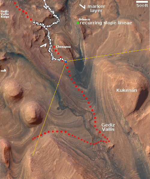
After more than a month of struggle to get Curiosity to maneuver uphill through a very rocky and steep terrain, the science team today finally announced that the rover had topped the ridge and could once again see its way forward into Gediz Vallis, the slot canyon it plans to use as its route up Mount Sharp.

The panorama above, cropped, reduced, sharpened, and annotated to post here, was taken on June 29, 2023 following Curiosity’s last move forward. The yellow lines on the overview map to the right indicate the approximate area covered by this panorama. The red dotted line on both images indicates Curiosity’s planned route, with the white dotted line its actual course.

The white ridge to either side of the central peak dubbed Kukenan is actually the higher flanks of Mount Sharp. The peak of Kukenan is about a half mile away and about 400 feet higher, with those white flanks about 2.5 miles beyond. The actual peak of Mount Sharp is about 25 miles farther south and about 17,000 feet higher.

The panorama makes clear that the path forward is not going to be any less rough for Curiosity and its damaged wheels. Expect progress to be slow for many months to come.

0 comments
1 64 65 66 67 68 89