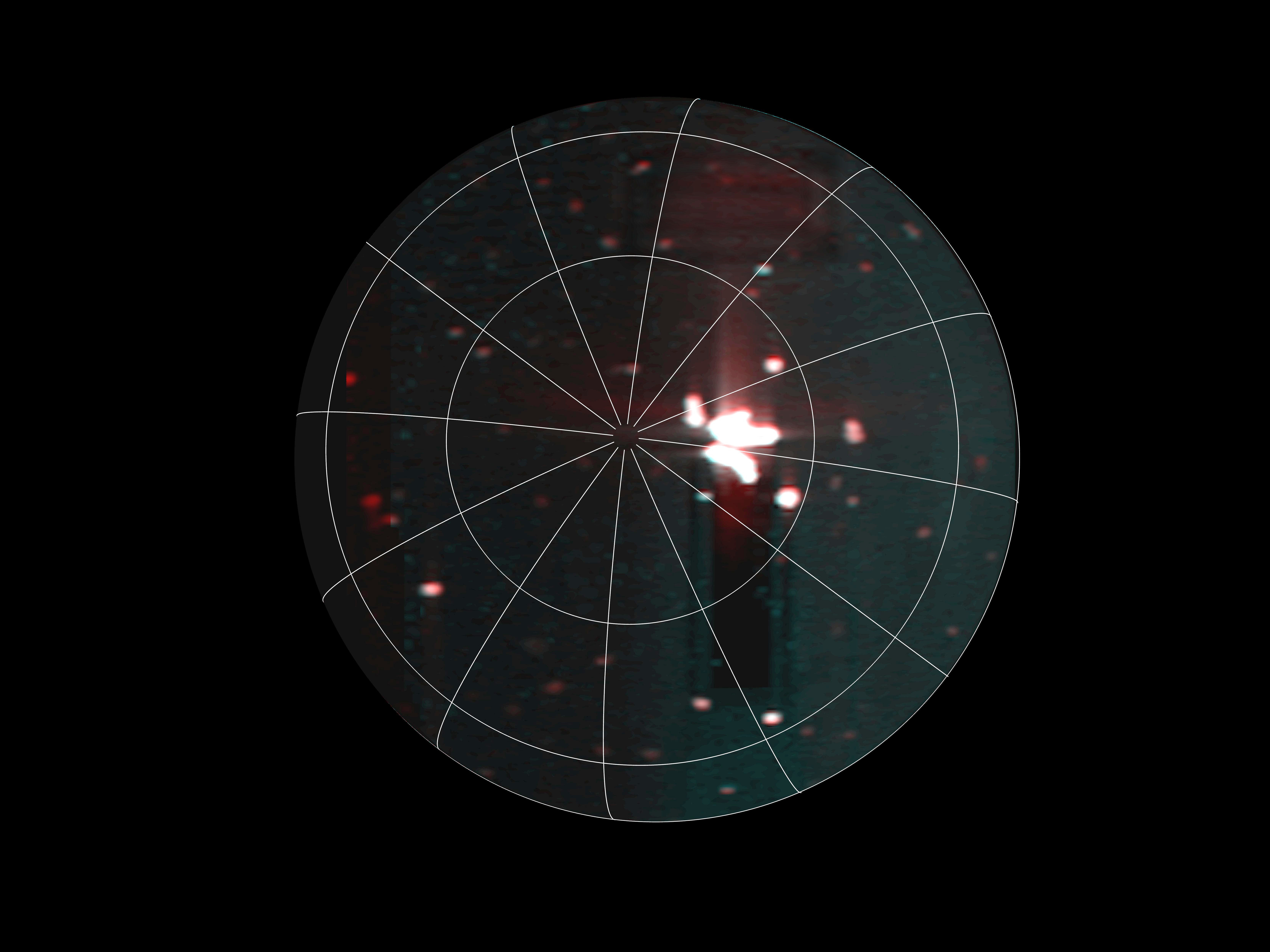
A cluster of strange terrain in Martian glacier country

Overview map

A cluster of strange terrain on Mars
Click for original image.

Cool image time! The picture to the right, rotated, cropped, reduced, and sharpened to post here, was taken on October 21, 2023 by the high resolution camera on Mars Reconnaissance Orbiter (MRO).

The science team labels this “patterned ground.” I see instead a whole range of inexplicable Martian geological features that, while each has been documented previously, each remains puzzling as to its formation process.

First there is the stucco-like peaks of all sizes on the upper left. This surface really looks like it had been wet plaster covered with Saran Wrap that had its peaks pulled up when that wrap was pulled off quickly.

Then there is brain terrain on the right. Always associated with glacier features on Mars, these convolutions are unique to Mars and as yet not entirely understood.

Next there is the circular arc on the middle left. It appears to be the remains of an impact crater now filled partly, but if so why has its northern rim disappeared so completely?

If you look close at the image above as well as the full image, you will find other mysterious features as well.

The location is the white dot on the overview map above. The rectangle in the inset shows the area covered by this picture, part of the floor of an unnamed eighteen-mile-wide and one-mile deep crater. The glacial material that appears to fill its interior as well as the splash apron that surrounds it all suggest the ground here is impregnated with water ice. Located as it is on the western end of the 2,000-mile-long north mid-latitude strip I dub glacier country — where practically every image shows glacial features — this conclusion is not surprising.

In fact, this photo illustrates well the alieness of Mars. We understand glaciers and ice, but on Mars, with its very cold temperatures, one-third Earth gravity, and thin atmosphere, those glaciers and ice are able to do things that we don’t yet understand. Untangling these geological processes will take decades of work, and likely will not be completed until people can walk the Martian surface and study it up close.

And won’t that be fun?

Double-ringed crater near the Starship landing zone on Mars

Double-ringed crater
Click for original image.

Cool image time! The picture to the right, rotated, cropped, reduced, and sharpened to post here, was taken on September 10, 2023 by the high resolution camera on Mars Reconnaissance Orbiter (MRO). It shows what the scientists label simply as a “double-rim crater.”

If you look close you might not be unreasonable to call this instead a triple-rim crater, as there appear to be two rings on each side of the highest crater rim.

Multple rings in craters are not rare. We see many on the Moon. Most however are associated with very large impacts, and are an expression of the ripples formed at impact, not unlike the ripples seen when you drop a pebble in water. Unlike water ripples, the ripples formed in rock are impact melt that quickly refreezes, thus capturing those ripples as concentric rings.

In this case, these rings likely signal not freezing rock but freezing ice.
» Read more

Endless ash fields on Mars

Endless ash fields on Mars
Click for original image.

Cool image time! The picture to the right, cropped, reduced, and sharpened to post here, was taken on September 18, 2023 by the high resolution camera on Mars Reconnaissance Orbiter (MRO).

It shows the very typical surface on a high plateau in Mars’ dry tropical regions. The dunes you see here, in this very small slice, cover a region about 80 miles square, with the prevailing winds appearing to consistently blow from the northeast to the southwest and forming these endless striations.

The dunes are made of volcanic ash, and the size of this particular ash field gives us a sense of the past volcanic activity that once dominated the red planet. Once, the atmosphere was filled with ash, which covered the ground across large regions. In the subsequent eons the thin Martian atmosphere has reshaped and piled that ash into giant mounds hundreds of miles across, with the surface striated as we see here.
» Read more

The Surt volcano on Io

The Surt volcano on Io in close-up
Click for original image.

Cool image time! The picture to the right, rotated, reduced, and sharpened to post here, was taken by Juno during its 57th close-fly of Jupiter on December 30, 2023. It shows of one of the many volcanoes that cover and continually recoat the surface of the Jupiter moon Io.

The picture was initially processed by citizen scientist Gerald Eichstädt. Thomas Thomopoulos then zoomed in and added additional enhancements to this particular area. (I thank Thomas for his additional help in making this post happen.)

The location is an active volcano named Surt, which has been observed to erupt several times since the 1970s, with its February 2001 eruption the most powerful yet observed on Io, though the pictures by the Jupiter orbiter Galileo taken before and after revealed few significant surface changes.

The picture itself shows a region where major changes have definitely occurred. The large arc of mountains across the photo’s center suggests the remaining half of a large caldera, its northern half now either buried or destroyed. The deep obvious hole inside that crescent appears to be the main vent from which the recent eruptions have spewed, as indicated by the light-colored apron surrounding it.

In the southwest section of that large mountain arc is a distinct ridgeline with a small circular curve in its middle that suggests a former volcanic cone, its northern half now gone.

To put it mildly, Io appears a very alien place, shaped entirely and continuously by endlessly volcanic eruptions that spread lava across its entire surface repeatedly.

Layered volcanic vent on Mars

Layered volcanic vent on Mars
Click for original image.

Cool image time! The picture to the right, rotated, cropped, reduced, and sharpened to post here, was taken on August 31, 2023 by the high resolution camera on Mars Reconnaissance Orbiter (MRO), and shows what the science team labels as a “vent near Olympica Fossae.”

The grade within the fissure is downhill to its center. Outside the vent the grade is downhill to the north and south, with the overall grade sloping to the west as well. Note the layers on each side of the depression. Each indicates another volcanic flood event that laid down another layer of lava. At some point this vent either blew up through those layers, or it had remained opened during all those many events, the lava flowing out and acting like water to erode the layers on the north and the south.

As always, the scale of Martian geology is daunting, as shown by the overview map below.
» Read more

Canyons formed from the giant crack that splits Mars

Canyons formed by the giant crack that splits Mars
Click for original image.

Cool image time! The photo to the right, cropped, reduced, and sharpened to post here, was taken on September 22, 2023 by the high resolution camera on Mars Reconnaissance Orbiter (MRO). It shows a complex of north-south trending canyons, with easternmost cliff about 400 feet high (though the full drop to the large canyon on its east is closer to 800 feet).

These canyons however have nothing to do with ice or water flow. They were formed by underground tectonic forces that pushed the ground upward, forced it to split and form cracks. Those cracks in turn produced these canyons. In some cases, such as the depression on top of the central ridge, the formation process probably occurred because fissures formed below ground, causing the surface to sag.

As always, the hiker in me wants to walk up the nose of that ridge and then along its western edge, with the western canyon on my left and that smaller depression on my right.

The larger context of this location is in itself even more spectacular.
» Read more

The mining potential on Mars

The mining potential on Mars
Click for original image.

Cool image time! The picture to the right, cropped, reduced, and sharpened to post here, was taken on October 30, 2023 by the high resolution camera on Mars Reconnaissance Orbiter (MRO). Labeled simply as a “terrain sample,” it was probably taken not as part of any specific research project but to fill a gap in the schedule in order to properly maintain the camera’s temperature.

Nonetheless, the larger region where this photo is located is one of great interest to scientists as well as to future explorers. First note the colors. The wide variations between the bright orange of that peak (only a few tens of feet high) and the light orange and aqua-green of the bedrock to the north and south suggest a terrain with a lot of different materials within it.

The location is in the dry equatorial regions, so the swirls visible on the plateaus north and south of that small peak are not related to near surface ice. Instead, this is warped bedrock, with those swirls also suggesting material of a varied nature, exposed to the surface by erosion processes.
» Read more

Dunes on the floor of Valles Marineris

Overview map

Dunes on the floor of Valles Marineris
Click for original image.

Cool image time! The picture to the right, cropped, reduced, and sharpened to post here, was taken on September 26, 2023 by the high resolution camera on Mars Reconnaissance Orbiter (MRO). It shows a field of scattered elongated dunes on a flat older surface with craters and what appear to be smaller ripple dunes (in the lower left). The large elongated dunes tend to be oriented in an east-west manner, while the older tiny ripple dunes appear to have a north-south orientation.

Very clearly the larger dunes appear to be traveling across that flat older surface, though whether there is any documented movement is unknown. Generally (though there are exceptions) scientists have found most of the dunes on Mars to be either inactive, or if they are moving because of the wind that movement is very tiny per year. In this case there is one dark spot on the dunes, near the center of the picture, where it appears a collapse might have occurred, suggesting recent change.

On the center right of the picture is the end point of a long ridgeline extending 10 to 12 miles to the east and rising about 7,300 feet, as shown in the overview map above. The small rectangle in the inset shows the area covered by the photograph.

At the base of that ridgeline can be seen a series of terraces descending to the west, suggesting that this hill might be volcanic in nature, with each terrace indicating a separate lava flow. The location is in the dry equatorial regions, so near-surface ice is likely not an explanation.

In the inset the mountain wall to the north is the large mountain chain that bisects this part of Valles Marineris. It overwhelms this small 7,300-foot-high ridge, rising more than 22,000 feet from these dunes with its high point still one or two thousand feet below the rim of Valles Marineris itself.

Once again, the grand scenery of Mars amazes. Imaging hiking a trail along that ridgeline, with the mountains rising far above you to the north and south.

First Juno images of Io from December 30th fly-by

Io as seen by Juno on December 30, 2023
For original global image go here. For original of inset go here.

The first raw Juno images taken of the Jupiter moon Io during its close fly-by on December 30, 2023, the closest in more than twenty years, have been released by the science team and citizen scientists have begun processing them.

The global picture to the right, rotated and reduced to post here, was processed by Kevin Gill. The inset of the volcanic mountains near the terminator was processed by Thomas Thomopoulos. As he notes, to obtain better detail he enhanced the colors and image and then zoomed in.

In the inset, note the northeast flows coming off the two mountains near the center. With the lower mountain, this flow appears to lie on top of a larger flow that extended out almost to the mountain to the right.

Io is a planet of continuous volcanic activity. For example, when the global image above was taken, the plume of a volcano eruption was visible on the right horizon, as shown in this version, its exposure adjusted by Ted Stryk. Catching such eruptions on Io is not unusual, considering its continuous volcanic activity generated by the tidal forces the planet undergoes from its orbit around Jupiter. In fact, the very first plume was imaged in 1979 by Voyager 1 during its short fly-by, and proved a hypothesis of such activity that scientists had only published one week earlier.

The ancientness of rocks on Mars

Ancient rocks on Mars
Click for original image.

Cool image time! The picture to the right, cropped, reduced, and enhanced to post here, was taken on December 27, 2023 by the high resolution camera on the Mars rover Curiosity. It shows what is a somewhat typical rock found on the ground as Curiosity climbs Mount Sharp in Gale Crater.

Two features stand out. First, the many layers illustrate again the cyclical nature of Martian geology. Many sedimentary events occurred over a long time to create this rock, each cycle putting down a new layer, with some intervening time periods possibly removing layers as well. Such layering has now become evident in both ground photos taken by rovers as well as orbital images.

Second, the delicate nature of some layers indicates the incredibly slow erosion process on Mars, enhanced by the red planet’s one-third gravity. The atmosphere is incredibly thin, less than 0.1% of Earth’s. Yet given time the wind had been able to wear away the edges of this rock. The thin atmosphere and light gravity has also allowed some material to remain in a delicate manner that would be impossible on Earth.

Thus, for these thin flakes to have formed has required a great deal of time. The very nature of this rock speaks of an ancient terrain, shaped slowly by inanimate processes with no active life around to disturb things.

Curiosity science team releases movies of Mars from dawn to dusk

Using its front and rear hazard avoidence cameras, the Curiosity science team had the rover take two full sets of images looking in one direction for twelve hours straight in order to create two movies of Mars that show an entire day, from dawn to dusk.

I have embedded both movies below. From the press release:

When NASA’s Curiosity Mars rover isn’t on the move, it works pretty well as a sundial, as seen in two black-and-white videos recorded on Nov. 8, the 4,002nd Martian day, or sol, of the mission. The rover captured its own shadow shifting across the surface of Mars using its black-and-white Hazard-Avoidance Cameras, or Hazcams.

Instructions to record the videos were part of the last set of commands beamed up to Curiosity just before the start of Mars solar conjunction, a period when the Sun is between Earth and Mars. Because plasma from the Sun can interfere with radio communications, missions hold off on sending commands to Mars spacecraft for several weeks during this time.

The first looks forward, into Gediz Vallis, where Curiosity will eventually travel. The second looks back down Mt Sharp and out across the rim of Gale Crater.
» Read more

Mapping the major lava flood events in Mars’ volcano country

The volcanic events in Mars' volcano country
Click for original map.

In a paper just released, scientists have used the orbital data from Mars Reconnaissance Orbiter (MRO) to map on Mars forty different past volcanic eruptions of extensive flood lava covering large regions, all within the region I dub “volcano country” because its entire surface seems mostly shaped by flows of lava.

The map above, figure 1 from the paper, shows the study area (within the white rectangle), with its global context and additional information added by me on the right. Most of the largest earthquakes detected by InSight ran from north-to-south down the center of the white box. The named features are all large flood lava events, with the youngest being Athabasca. Within the Cerburus Plains feature the researchers mapped many smaller events which brought the total up to forty. From the abstract:

An area almost as large as Europe was investigated. The study revealed the products of more than 40 volcanic events, with one of the largest flows infilling Athabasca Valles with a volume of 4,000 km3. The surface appearance and material properties suggest that Elysium Planitia is composed of basalt, the most common type of lava on Earth. The area also experienced several large floods of water, and there is evidence that lava and water interacted in the past. However, while there could be ice in the ground today, it likely occurs in small patches.

None of these flood lava events involved the gigantic volcanoes that surround this region. Instead, the lava erupted from vents within this region, and then flowed downgrade to flood large areas, sometimes covering over parts of earlier lava floods. All also flowed much faster than lava on Earth, flooding vast regions — comparable to entire countries — often in mere weeks.

Juno’s closest image of Europa suggests recent surface activity

Juno's best image of Europa
Click for original image.

Analysis by scientists of the closest image of Europa taken during Juno’s close-fly on September 29, 2022 suggests that a particular strange feature, dubbed the “platypus” due to its shape, might be very young and indicate recent surface activity that could be related to underground liquid water.

That picture, reduced and sharpened to post here, is to the right. It is figure 2 of the paper. The description of this photo from the abstract:

Intricate networks of cross-cutting ridges and lineated bands surround an intriguing 37 km (east-west) by 67 km (north-south) chaos feature with a concentric fracture system, depressed matrix margins, and low-albedo materials potentially associated with brine infiltration. The morphology and local relief of the chaos feature are consistent with formation in the collapse of ice overlying a salt-rich lens of subsurface water. Low-albedo deposits, similar to features previously associated with hypothesized cryovolcanic plume activity, flank nearby ridges. The SRU’s high-resolution view of many types of features in a single image allows us to explore their regional context and greatly improve the geologic mapping of this part of Europa’s surface. The image reveals several relatively youthful features in a potentially dynamic region, providing baselines for candidate locations that future missions can investigate for present day surface activity.

SRU is Juno’s Stellar Reference Unit camera, designed to take pictures using only the low light of Jupiter reflected onto nighttime surfaces of Jupiter’s moons. It took this photo when Juno was only 256 miles above the surface.

This feature will obviously become a prime target for Europa Clipper when it arrives into orbit around Jupiter in April 2030. From this vantage point — safer than continuous exposure to Jupiter’s magnetosphere while in orbit around Europa — the spacecraft will do 44 close-flys of the moon.

Isolated mesa on Mars

An Isolated mesa on Mars
Click for original image.

Cool image time! The picture to the right, cropped, reduced, and sharpened to post here, was taken on August 13, 2023 by the high resolution camera on Mars Reconnaissance Orbiter (MRO).

The central butte is about 100 feet high. Not only are its flanks terraced, suggesting sedimentary layers, note the many black dots on its northern slopes. Those dots appear to be many boulders that appear to have rolled down the slopes to settle mostly near the mesa’s base.

The boxwork ridges to the west and south suggest the ground was fractured in some event to produce cracks, which were later filled with material that was erosion resistent. As the terrain was worn away by wind it left these ridges behind.

The prevailing winds in this region are believed to blow mostly to the south, which might explain the parallel ridges south of the mesa. Or not. On this I am guessing entirely.
» Read more

Curiosity takes a close-up of distant cliffs

Panorama on December 20, 2023
Panorama on December 20, 2023. Click for full image.

Close-up of a distant cliff
Click for original image.

Cool image time! The picture to the right, reduced and sharpened to post here, was taken on December 21, 2023 by the chemistry camera (ChemCam) on the rover Curiosity. Originally designed to take close-ups of rocks very nearby the rover, the science team over time discovered that they could also use this camera to get close-ups of very distant objects, providing them another way to study the geology in Gale Crater and on Mount Sharp.

The picture to the right I think shows the horizon area indicated by the arrow on the panorama above, taken the day before. Note the many many layers, a geological feature that Curiosity has discovered is ubiquitous on Mars. Over eons the entire surface of the red planet has been layered repeatedly by cyclical geological events, producing layers within layers within layers. I guarantee that when Curiosity gets closer to this cliff it will see layers inside the smallest layers ChemCam can see now.

The red dotted line on the panorama above indicates the approximate planned route that Curiosity will eventually take, cutting across in front of that mountain and turning south somewhere near but to the west of where the cliff in this picture is located.
» Read more

A glacial lake on Mars?

A glacial lake in a
Click for original image.

Cool image time! The picture to the right, rotated, cropped, reduced, and sharpened to post here, was taken on August 30, 2023 by the high resolution camera on Mars Reconnaissance Orbiter (MRO).

It shows what appears to be a glacial flow of ice, flowing downhill to the southwest and inside a wide canyon about three miles across. The canyon rims to the north and south are about 2,000 to 2,100 feet above the canyon’s lowest point, indicated by the string of “+” signs.

This close-up view immediately suggests a canyon whose glacier flows outward to the southwest into open lowland terrain, though the three craters, because they are undistorted, suggests that this flow is presently not active. That suggestion however would be wrong. It is always necessary to understand Martian geology to not only take close-in views at high resolution, but to zoom back and see the terrain in context.
» Read more

Ingenuity’s engineers explain what they have learned flying the helicopter on Mars

Link here. The essay details carefully the problems they have faced, and how they have not only overcome them but used them to refine operations to squeeze far more capabilities out of the helicopter, beyond its initial design.

Saving flight time saves energy, reduces heating, and provides more freedom to use slower speeds to tiptoe around disruptive terrain that might otherwise endanger or significantly degrade the landing accuracy of the helicopter. Higher speeds and higher accelerations reduce the time needed to execute a given flight path. Higher altitudes permit higher speeds, as the wider field of view helps to keep ground features in view of Ingenuity’s navigation camera longer, counteracting the effect of increased speed. Expanding Ingenuity’s flight envelope had the potential to relax flight planning constraints and allow Ingenuity to operate more effectively alongside Perseverance.

As a result, beginning with flight 45 the team has made changes to increase flight speeds and acceleration at every point of every flight, thus allowing the helicopter to fly higher and farther with less strain.

This report however does not provide any information on Ingenuity’s last two flights, especially its 68th, which did not go as planned. The helicopter appears to be in good shape (the team has already planned the 69th flight, which was supposed to happen two days ago), but a more detailed update would be appreciated.

Glacial layers in Mars’ glacier country

Glacial layers in Mars' glacier country
Click for original image.

Cool image time! The picture to the right, cropped, reduced, and sharpened to post here, was taken on August 20, 2023 by the high resolution camera on Mars Reconnaissance Orbiter (MRO). It features a 250-foot-high north-south cliff that appears to have numerous horizontal layers within it.

Moreover, both on the plateau above the cliff as well as the floor below it, the entire surface seems to resemble a thick snow/ice field, made even more evident by the distortion of many craters and the apparent glacial material inside each crater.

The layers suggest that this ice was laid down in a series of cycles. During cold periods snow fell and accumulated as ice over time. When things became warmer some of that ice sublimated away, but not all. With the next cold cycle a new layer was put down.

The many layers suggest many climate cycles on Mars, none of which were caused by SUVs or coal-firing electrical power stations.
» Read more

A land of buttes on Mars

A land of buttes on Mars
Click for original image.

Cool image time! The picture to the right, cropped, reduced, and sharpened to post here, was taken on October 4, 2023 by the high resolution camera on Mars Reconnaissance Orbiter (MRO). Labeled a “terrain sample” by the science team, it was likely shot not as part of any specific research project but to fill a gap in the schedule so as to maintain the camera’s proper temperature. When the camera team has to do this they try to pick targets that are of some interest. Usually they succeed, considering the enormous gaps we presently have of Mars’ geological history.

This picture is no different. It shows a land of buttes and mesas, all ranging from 20 to 200 feet high, surrounded by canyons filled with ripple dunes of Martian dust. If you look at the floor of those canyons closely, you will notice that where there are no ripple dunes the ground is slightly higher and smooth. It is as if that ground was a kind of sandstone that was eroded away by wind into sand, which then formed the dunes.
» Read more

Another minor canyon on Mars that would be a world wonder on Earth

Another minor canyon on Mars
Click for original image.

Cool image time! The picture to the right, rotated, cropped, reduced, and sharpened to post here, was taken on August 6, 2023 by the high resolution camera on Mars Reconnaissance Orbiter (MRO). It shows the steep north canyon wall of one small part of the Martian canyon complex dubbed Noctis Labyrinthus

The elevation drop in this picture is about 8,000 feet, but the canyon’s lowest point is several miles further south and another 7,000 feet lower down. What is most intriguing about the geology here is its age. If you look at the full resolution image, you will see that there are scattered small craters on the smooth slopes that resemble sand that gravity and wind is shaping into those long streaks heading downhill.

Those craters, however tell us that these smooth slopes are very old, and have not changed in a long time. Furthermore, though the material appears to look like soft sand, the craters also tell us it long ago hardened into a kind of rock. If wind is shaping this material, it must be a very slow process.

The light areas on the rim as well as the ridge peaks below the rim suggest the presence of geological variety, which fits with other data that says Noctis Labyrinthus has a wide variety of minerals.
» Read more

Perseverance looks at Jezero Crater in high resolution

Perseverance's future route
Click for full image.

The Perseverance science team earlier this week released a mosaic taken by the rover’s high resolution over three days in November, showing the entire 360 degree view of Jezero Crater from where Perservance sat during the month long solar conjunction that month, when communications with Mars was cut off due to the Sun being in the way.

Part of that panorama, significantly reduced, cropped, and enhanced, is posted above, focusing on the western rim of Jezero Crater and the route that Perseverance will likely take in the future. Below is an overview map that indicates by the yellow lines the approximate area covered by this picture. The light blue dot marks Perseverance’s present location, while the dark blue dot marks where it took the mosaic and was also stationed during that solar conjunction. The dotted red line on both images marks the approximate proposed route that the science team is considering for leaving Jezero crater. Instead of going out through Neretva Vallis, they are instead considering heading south to go over the crater’s rim itself.

Ingenuity’s present position is marked by the green dot. This is where it landed after flight 67 on December 2nd. On December 8th the helicopter’s engineering team had released the flight plan for flight 68, scheduling it for December 9th, but as of this date it appears that flight has not occurred. I suspect the delay is because communication between Ingenuity and Perseverance is presently spotty, though the Ingenuity team has released no information.

Overview map
Click for interactive map.

The end of a 400-mile-long Martian escarpment

The end of a 400-mile-long escarpment
Click for original image.

Cool image time! The picture to the right, cropped, reduced, and enhanced to post here, was taken on August 14, 2023 by the high resolution camera on Mars Reconnaissance Orbiter. It shows the cracked top of a enscarpment, with the bottom point to the west about 2,400 feet lower in elevation.

The north-south cracks at the top of the cliff indicate faults. They also suggest that the cliff itself its slowly separating from eastern plateau. North from this point, beyond the edge of this picture, are several places where such a separation has already occurred, with the collapsed cliff leaving a wide pile of landslide debris at the base.

This cliff actually continues north for another 400 miles, suggesting that the ground shifted along this entire distance, with the ground to the east going up and ground to the west going down. Because the cliff is such a distinct and large feature, it has its own name, Claritas Rupes, “rupes” being the Latin word for cliff.
» Read more

Stripped screws preventing access to Bennu samples

According to the scientists working to extract the samples from the asteroid Bennu brought back by the OSIRIS-REx sample return capsule, the work has been stymied because of two stripped screws.

Last month, researchers at the Johnson Space Center in Houston, Texas, discovered that two of the 35 screws that fasten the lid of the sample-return canister couldn’t be opened — blocking access to the remainder of the space rock. Curators used tweezers to pull out what they could, but NASA is now making new screwdrivers so it can get into the equipment it flew billions of kilometres across the Solar System to the asteroid Bennu and back.

Because the capsule is kept within a sealed glovebox to prevent the samples from being contaminated by the Earth environment, removing the screws requires NASA to manufacture special screwdrivers that will also not contaminate that environment. This work is what is causing the delay.

Martian crater or mud caldera?

Martian crater or volcano?
Click for original image.

Cool image time! The picture to the right, cropped, reduced, and sharpened to post here, was taken on October 18, 2023 by the high resolution camera on Mars Reconnaissance Orbiter (MRO).

The scientists only call this a “feature,” likely because they don’t wish to guess as to its nature without more data. However, the 2.5 mile wide splash apron around the central double crater certainly merits a closer look. That double crater could be from impact, but it also could be a caldera, with the apron the result of material that flowed from the caldera.

That there appear to be fewer craters on the apron than on the surrounding terrain strengthens this last hypothesis. The apron would have erased many earlier impact craters, resulting in this lower count.

The location however suggests that if this feature was volcanic in origin it might not have been spewing out magma.
» Read more

Craters in a row

Craters in a row
Click for original image.

Cool image time from Mars! The picture to the right, rotated, cropped, reduced, and sharpened to post here, was taken on October 13, 2023 by the high resolution camera on Mars Reconnaissance Orbiter (MRO). It highlights a string of craters, all lined up in an almost straight line.

Were these craters caused by the impact of an asteroid that broke up as it burned its way through the thin Martian atmosphere? The lack of any raised rims argues instead that these are sinks produced not from impact but from a collapse into a void below, possibly a fault line.

Yet, almost all of the craters in this image, even those not part of this crater string, show no raised rims. If sinks, the voids below don’t seem to follow any pattern, which once again argues in favor of random impacts, with the string produced by a bolide breaking up just prior to hitting the ground.
» Read more

The steep mountain slopes inside Valles Marineris

Overview map

The steep mountain slopes inside Valles Marineris
Click for full image.

Time for another cool image showing the dramatically steep terrain of Valles Marineris on Mars, the largest known canyon in the solar system. The picture to the right, cropped, reduced, and enhanced to post here, was taken on October 31, 2023 by the high resolution camera on Mars Reconnaissance Orbiter (MRO).

The scientists rightly label this picture “Steep Slopes in West Melas Chasma”. The red dot marks the high point on this ridgeline. The green dot at the upper left marks the lowest point in the picture, about 4,800 feet below the peak. The blue dot on the right edge marks the low point on the ridge’s eastern flank, about 4,600 feet below the peak. The cliff to the east of the peak drops quickly about 1,300 feet in less than a mile.

On the overview map above, the white dot marks the location. The inset is an oblique view, created from a global mosaic of MRO’s context camera images, with the white rectangle indicating approximately the area covered by the picture above.

The immense scale of Valles Marineris must once again be noted. The elevations in this picture are comparable to the descent you make hiking down from the South Rim of the Grand Canyon. They pale however when compared to Valles Marineris. In the inset I have indicated the rim and floor of Valles Marineris in this part of the canyon. The elevation distance between the two is 18,000 feet.

In other words, the canyon to the east of this ridge is quite comparable in size to the Earth’s Grand Canyon, and it is hardly noticeable within the larger canyon of Valles Marineris.

Big Martian gullies partly filled with glacial material

Overview map

Big Martian gullies partly filled with glacial material

Cool image time! The picture to the right, cropped, reduced, and sharpened to post here, was taken on August 18, 2023 by the high resolution camera on Mars Reconnaissance Orbiter (MRO). It shows what the scientists dub as “large gullies with infilled alcoves.”

Gullies on Mars were one of the first discoveries by orbiters of small-scalle potential water-caused features on the Red Planet. The favorite explanation for their formation today involves the seasonal freeze-thaw cycle, combined with the deposition of ice and dry ice frost in the winter. When that ice and dry ice sublimates away in the spring it causes collapse and erosion, widening the gullies.

These gullies also exhibit evidence that underground and glacial ice might contribute as well. The material in the largest gullies looks like a mixture of glacial material and dust and debris. It could also be that there is ice impregnated in the ground, which can cause large collapses when it sublimates away.

The white rectangle on the overview map and inset above marks the location of this picture, on the western rim of a 13-mile-wide unnamed crater inside the western portion of the 2,000-mile-long mid-latitude strip on Mars I dub glacier country, since every image from orbit shows evidence of glaciers.

This picture is no different, as the horizontal cracks at the base of the crater rim suggests the glacier that fills the crater floor is being pulled apart by gravity at its edges. The elevation drop from the top of the rim to the floor is about 3,200 feet, so any ice on that slope will definitely be stressed by gravity. Such cracks are therefore not surprising.

Psyche takes its first pictures

The spacecraft Psyche — going to the metal asteroid Psyche — has successfully taken its first pictures, proving its camera and pointing system work as planned.

The pictures, taken on December 4, 2023 from about 16 million miles from Earth, are actually quite boring, merely showing a field of stars. However,

The imager instrument, which consists of a pair of identical cameras, captured a total of 68 images, all within a star field in the constellation Pisces. The imager team is using the data to verify proper commanding, telemetry analysis, and calibration of the images. …The imager takes pictures through multiple color filters, all of which were tested in these initial observations.

At this moment all looks good for Psyche’s eventual arrival at Psyche in 2029.

Lava-filled Martian crater

Lava-filled Martian crater
Click for original image.

Cool image time! The picture to the right, rotated, cropped, reduced, and sharpened to post here, was taken on July 10, 2023 by the high resolution camera on Mars Reconnaissance Orbiter (MRO). It shows the northeast corner of an unnamed 7-mile-wide crater, located near the equator in the dry Martian tropics.

The MRO science team labels this “crater and lava fill”, suggesting that the crater interior is filled with lava material. The nature of that crater floor reinforces this conclusion, as it is relatively smooth and does not have rough aspects of glacial material found in craters in the mid-latitudes. Instead, it looks like a frozen lake of lava that has the peaks of mostly buried features poking up at various spots.

What makes this crater interesting however are the gullies on the northern interior rim. Gullies on Mars are normally thought to be associated with some water-frost-ice process, probably seasonal, where the thaw-freeze cycle causes small collapses and avalanches. Yet, this crater is almost at the equator, in a very dry region where no evidence of near-surface ice is found. Gullies here suggest the hypothesis for explaining the gullies on Mars have not quite solved the mystery.
» Read more

Thick windblown ash in Mars’ largest mountain region

Thick windblown ash near Mars' largest volcano
Click for original picture.

The cool image to the right, rotated, cropped, reduced, and sharpened to post here, was taken on September 1, 2023 by the high resolution camera on Mars Reconnaissance Orbiter (MRO), and shows what the scientists label as “Erosional Features on Olympus Mons.”

What is eroding? Based on the picture itself the first guess is volcanic ash, as these features strongly resemble the many features seen in the Medusae Fossae Formation, the largest volcanic ash field on Mars — about the size of the subcontinent of India.

Medusae however is many thousand miles away, and is not apparently related to any specific volcano. These features are instead directly linked to Olympus Mons, the largest known volcano in the solar system. However, much of the terrain for many hundreds of miles around Olympus is covered with flood lava, which was deposited and hardened quickly to form smooth featureless plains that have resisted much erosion over the eons. Here the terrain is clearly eroded, which suggests that if the material here is volcanic, it was laid down not by flood lava but by falling ash that got compressed but was easily friable and could be blown away by the winds of Mars’ thin atmosphere.
» Read more

1 8 9 10 11 12 59