Perseverance reaches top of Jezero Crater rim

The view west out of Jezero Crater
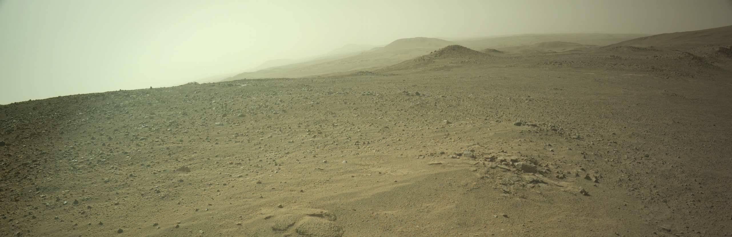
Click for high resolution panorama. For original images, go here and here.

Overview map
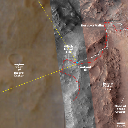
Click for interactive map.

After spending more than three and a half years exploring the floor of Jezero Crater, the rover Perseverance has finally reached the top of the crater’s western rim, and is about to begin exploring the mountainous and potentially rich mining region to the west.

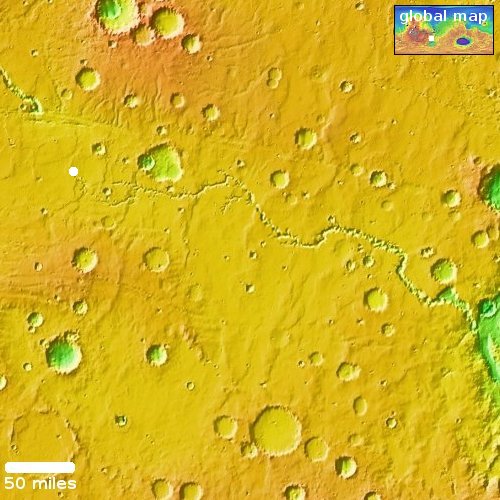
The panorama above, created from two pictures taken by Perseverance’s right navigation camera on December 11, 2024 (here and here), has been cropped, reduced, enhanced, and annotated to post here. It looks west into that mountainous region, with the yellow lines on the overview map to the right indicating the approximate view. The blue dot on that map marks Perseverance’s present position, on top of Lookout Hill, the name the rover team has given to that spot on the rim.

The low resolution of the region beyond the grey strip is unexplained. For some reason the rover team has not yet updated the interactive map showing Perseverance’s travels with the many high resolution pictures that Mars Reconnaissance Orbiter (MRO) has taken of this region, in anticipation of Perseverance’s travels there. I expect however this will change shortly.

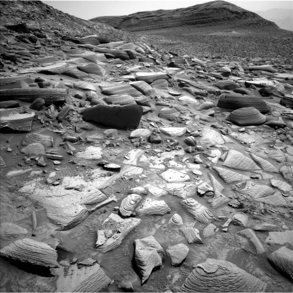
Witch Hazel Hill is the first target beyond the rim, where there is an outcrop 330-feet-high with many layers. The rover will then head downhill and south to check out a spot that the scientists believe might show features existing from before Jezero Crater was formed. The rover will then head back up to the rim further south to look at an outcrop of blocks that might actually be ejecta from another much larger Martian impact.

These blocks may represent ancient bedrock broken up during the Isidis impact, a planet-altering event that likely excavated deep into the Martian crust as it created an impact basin some 745 miles (1,200 kilometers) wide, 3.9 billion years in the past.

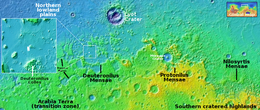
Jezero sits on the northwestern rim of Isidis.

0 comments

Curiosity begins to round the corner out of Gediz Vallis

Curiosity looks ahead
Click for original image.

According to an update yesterday from the rover team, the Mars rover Curiosity has finally begun to round the corner of the northern nose of the long ridge dubbed Texoli that forms the western wall of Gediz Vallis, the slot canyon that the rover has been exploring since August 2022.

The picture to the right, reduced, sharpened, and annotated to post here, was taken on December 10, 2024 and shows the view looking west. The red dotted line indicates the planned route. As the rocky ground indicates, travel forward in the near term will be interesting. As noted in the update:

While we want to head southwest, we had to divert a bit to the north (right of the image shown) to avoid some big blocks and high tilt. The path is very constrained in order to avoid driving over some smaller pointy rocks, scraping wheels along the sides of blocks, or steering into the side of blocks that might cause the steering to fail. And we also needed to worry about our end-of-drive heading to be sure the antenna will be clear to talk to Earth for the next plan. We ended up relying on the onboard behavior to help us optimize everything by implementing a really interesting and curvy 24-meter path (about 79 feet).

» Read more

0 comments

Land of knobs

Land of knobs
Click for original image.

Cool image time! The picture to the right, rotated, cropped, reduced, and sharpened to post here, was taken on July 17, 2024 by the high resolution camera on Mars Reconnaissance Orbiter (MRO). Labeled merely as a “terrain sample,” it was likely taken not as part of any specific research project, but to fill a gap in the camera’s schedule in order to maintain its proper temperature.

When the camera team does this, they try to pick interesting targets. In this case, they targeted this 400-foot-high pointy-topped hill. The smoothness of its slopes suggest this hill is made up largely of packed dust, possibly a hardened former dune. This hypothesis seems strengthened by the erosion on the eastern slopes, which appears to be areas where that packed sand has worn or blow away.

Think of sandstone in the American southwest. It is made of sand that has hardened into rock, but wind and water and friction can easily break it back into dust particles, resulting often in the spectacular and weird geological shapes that make the southwest so enticing.

But is this sand?
» Read more

2 comments

Io’s volcanoes get their lava from separate magma chambers, not a global underground ocean of magma

Io's interior as presently theorized
Click for original animation.

Using data collected from Juno’s multiple fly-bys of the Jupiter moon Io, scientists now hypothesize that the moon does not have a global underground ocean of magma, feeding its many volcanoes, but that instead each volcano is fed its lava from a separate magma chamber.

The graphic to the right illustrates the present conclusion. You can read the paper here [pdf]. From the press release:

The Juno team compared Doppler data from their two flybys with observations from the agencyโ€™s previous missions to the Jovian system and from ground telescopes. They found tidal deformation consistent with Io not having a shallow global magma ocean.

โ€œJunoโ€™s discovery that tidal forces do not always create global magma oceans does more than prompt us to rethink what we know about Ioโ€™s interior,โ€ said lead author Ryan Park, a Juno co-investigator and supervisor of the Solar System Dynamics Group at JPL. โ€œIt has implications for our understanding of other moons, such as Enceladus and Europa, and even exoplanets and super-Earths. Our new findings provide an opportunity to rethink what we know about planetary formation and evolution.โ€ [emphasis mine]

The highlighted words indicate the significance of this data. It possibly suggests that the underground oceans of water that have been theorized for these other moons — where life could possibly exist — might be mistaken. Instead, they might have smaller pockets of water, similar to Io’s many magma chambers.

Everything here however is uncertain, including these new conclusions about Io. We just don’t have enough data from any of these moons to make any definitive conclusions.

0 comments

“Thar’s ice in them hills!”

Overview map

Thar's ice in them hills!
Click for original image.

Cool image time! The picture to the right, cropped, reduced, and sharpened to post here, was taken on September 25, 2024 by the high resolution camera on Mars Reconnaissance Orbiter (MRO). It shows what the camera team labels as a “mound in the southern highlands.”

The mound in question sits in the center of the sunken depression, and at the highest resolution shows its top to be cracked and broken, as if something is attempting to break out by pushing up from below.

Everything about this picture screams near-surface ice. The cracked mound suggests ice sublimating into gas, which applies pressure to the surface and thus the cracks. The depression suggest that much of the near-surface ice at this location has already disappeared, causing the ground to sag. All the craters lack upraised rims. If caused by impacts, the ground here was soft enough that the impactor simply sank into the ground. Imagine dropping a rock you’ve heated into snow. It would simply leave a hole.

But there’s more. The white dot in the overview map above marks the location. In the inset, the lighter area surrounding this depression resembles an ice sheet that is slowly sublimating away. There are also other similar depressions in that lighter area. The lighter area also has fewer craters than the darker regions nearby, suggesting that this ice sheet covers the older impacts.

The location is in the southern cratered highlands in a mid-latitude region where many images indicate the existence of layers of ice deep below ground. This picture is more evidence of the same, but it also indicates the presence of ice very close to the surface as well.

The orbital data continues to tell us that Mars is not a dry desert like the Sahara, but an icy desert like Antarctica. There will be plenty of water for future colonists. All they will have to do is stick a shovel in the ground, dig it up, and process it.

0 comments

Strange flat layers on Mars

Strange layers on Mars

Cool image time! The picture to the right, rotated, cropped, reduced, and enhanced to post here, was taken on July 16, 2024 by the high resolution camera on Mars Reconnaissance Orbiter (MRO). It shows what MRO’s camera team labels as “layers near ridge in Argyre Planitia.”

The layers are strange because there is so little topographic difference between them. Though the ground slopes downward from the south to the north, dropping about 1,300 feet, it does so almost smoothly. The layers show relatively little topographic relief.

And what caused the circular shape? Is it evidence of a buried crater? And if so, why so little relief at its rim?

As always, the overview map provides some answers.
» Read more

0 comments

The strange beginning of a 300-mile-long meandering canyon on Mars

Overview map

Today’s cool image will be unlike most cool images, in that we will begin not with the image but with the overview map to the right. The long meandering canyon at the center of this map is Nirgal Vallis, a 300-mile long canyon on Mars that eventually drains to the east into a much larger drainage system that runs south-to-north several thousand miles into the Martian northern lowland plains.

At first glance Nirgal Vallis invokes a river system. It starts in the west as several branches that combine to form a single major canyon meandering eastward until it enters that south-to-north system. To our Earth eyes, this canyon suggests it was carved by water flowing eastward, the many drainage routes combining as they flowed downhill.

Today’s the cool image, its location indicated by the white dot, tells us however that liquid water might not have been what created this canyon.
» Read more

1 comment

Strange mesas in the glacier country of Mars

Overview map

Strange mesas in the glacier country of Mars

Cool image time! The picture to the right, cropped, reduced, and sharpened to post here, was taken on October 2, 2024 by the high resolution camera on Mars Reconnaissance Orbiter (MRO). The white dot in the overview map above marks the location, inside the chaos terrain of Deuternilus Mensae and part of the 2,000-mile-long mid-latitude Martian strip I label “glacier country,” because practically every image of every part of its landscape has glacial features. For example, the splash apron around the picture’s largest crater as well as the material within it all suggest some form of glacial activity and near-surface ice.

The scientists label what they see here as “Mesas in Small Craters.” These features are located in a low flat plain that geologists think was created when the ground eroded away, leaving behind scattered high plateaus that indicate the previous surface elevation. The geological map [pdf] of this plain describes it as follows:

Smooth, relatively featureless materials with regions of variable albedo north of continuous cratered highlands; exhibits scattered clusters of small circular to irregular knobs.

Based on the many accumulated photos from MRO, the general conclusion is that we are looking at a sheet of ice/dirt and covered by a thin dust layer that acts to protect that ice from sublimating away. When wind blows that dust off and the summer sun hits that near-surface ice, however, it does sublimate in bursts, which thus provides an explanation for the erosion that caused these low featureless plains.

As for these strange terraced mesas inside these distorted hollows, my guess is that the mesas predate the icesheet and are made of material with less ice impregnated within it. As that ice sublimates away it creates the craters within which the mesas remain. The terraces suggest a earlier series of geological sedimentary history.

0 comments

Unusual light-colored Martian dunes

Unusual light-colored Martian dunes
Click for original image.

Cool image time! The picture to the right, cropped, reduced, and sharpened to post here, was taken on September 27, 2024 by the high resolution camera on Mars Reconnaissance Orbiter (MRO).

The picture was simply labeled a “terrain sample,” which usually means it was taken not as part of any specific research request, but to fill a gap in the schedule so as to maintain the camera’s proper temperature. When such gap-filler pictures are necessary, the MRO camera team tries to snap something of interest. Sometimes the pictures end up somewhat boring. This time however the picture highlights a dune field that is unusually light in color.

Since most Martian sand is volcanic in origin, it tends to look dark in orbital pictures. That this sand looks bright could be because it is inherently different, or it could be that lighting conditions make what normally looks dark to look bright instead.
» Read more

0 comments

Etched terrain on Mars

Etched terrain on Mars
Click for original image.

Today’s cool image is another example of what I call a “What the heck!” image. The picture to the right, simply cropped to post here, was taken on September 22, 2024 by the high resolution camera on Mars Reconnaissance Orbiter (MRO).

It shows what the scientists label as “etched terrain,” an incredibly twisted and eroded landscape that to me actually defies description. In trying to research what scientists have learned and theorized about this terrain, it appears they think it is material that flowed over older terrain (thus its lack of many craters) that was subsequently eroded by later processes.

Why it eroded so strangely however is not really understood. It could have been caused by near-surface ice sublimated to the surface and thus causing many breaks, but since this terrain is located right on the equator in the dry tropics, it is a very long time since water was present here.
» Read more

1 comment

Martian mountains amidst a deep sea of sand

Overview

A Martian mountain surrounded by a sea of sand
Click for original image.

Cool image time! The picture to the right, cropped, reduced, and sharpened to post here, was taken on July 9, 2024 by the high resolution camera on Mars Reconnaissance Orbiter (MRO). The white dot on the overview map above marks the location, inside the deep enclosed and very large 130-mile-wide depression dubbed Juventae Chasma.

The mountain in the picture raises above the sand sea that surrounds it from 1,000 to 2,300 feet, depending on direction, as the downhill grade of the sand sea is to the east. Thus, on the west the mountain rises less, while on the east the height is the greatest.

The inset illustrates the extent of the sand sea. It covers the ground for many miles in all directions. The way the sand surrounds these mountains suggests the prevailing winds blow from the west to the east. In fact, the facts suggest that this sand is volcanic ash that was blown into Juventae from many eruptions that occurred over time to the west, where it got trapped. The wind and gravity deposited the sand into the 20,000 to 25,000-foot-deep chasm, where the wind was insufficient to lift it out again.

One wonders how deep that sand sea might be. The lack of any surface features at all suggests it could be quite deep, burying everything but the highest peaks. In fact, if a geologist could drill a core through that sand I suspect he or she might be able to document the entire eruption history of much of Mars.

1 comment

Distinct gully draining the side of a Martian crater

Distinct gully in crater on Mars
Click for original image.

Cool image time! The picture to the right, cropped, reduced, and sharpened to post here, was taken on August 20, 2024 by the high resolution camera on Mars Reconnaissance Orbiter (MRO). The science team labels the entire picture simply as “gully,” obviously referring to that distinct and somewhat deep hollow in the middle of the picture.

Most gullies that have been found on Mars tend to look more eroded and rougher than this hollow. Here, it appears almost as if the process that caused this gully occurred relatively recently, resulting in its sharp borders that have not had time to crumble into softer shapes.

The crater interior slope is about 1,500 feet high. Whatever flowed down it however did not do it in an entirely expected manner. As it flowed it curved to the west, so that the impingement into the glacial material that fills the crater floor is to the west of the gully itself. Either that, or that impingement was caused by a different event at a different earlier time.
» Read more

0 comments
1 16 17 18 19 20 157