Perseverance gets close to its first cliff

Perseverance's first cliff
Click for full image.

Time for some cool images from Perseverance! The rover, now on Mars for more than a year, has finally begun its journey up the delta of material that some time in the past flowed through a gap in the rim of Jezero Crater. In doing so, it has also finally got close to a nearby cliff, within fifty feet or so, and used its high resolution left mast camera (mastcam) to take the photos to the right. The first, cropped and reduced to post here, was a wider shot taken on June 10, 2022, with the red arrow pointing to the part of the cliff featured in the second image below, taken on June 12, 2022, after the rover had moved in closer. This second photo is also cropped and reduced to post here.
» Read more

Dusty Gale Crater in the winter

Curiosity's view to the north, May 25, 2022
Click on image for full resolution panorama. For original photos, go here, here, here, here, and here.

Overview map
Click for interactive map.

Cool image time! The panorama above, created from five images taken by Curiosity’s left navigation camera on May 25, 2022, looks north across the floor of Gale Crater at its rim about 25 miles away.

The butte on the left I think (though I am not certain) is the backside of the same butte seen from the front in December 2021. Then, Curiosity was below it looking up. Now, Curiosity is above it looking down.

For scale, that butte is about ten feet high. Navarro Mountain on the right is about 450 feet high, but looks less impressive because it is farther away.

It is now winter in Gale Crater, a time period when there is more dust in the atmosphere. This fact becomes very evident if you compare this panorama with a similar one taken in December 2021 in the Martian fall. Then, the air is crystal clear, and the rim can be seen in great detail. Now, though visible (barely) on the left, the haze makes the more distant peaks on the right almost invisible.

Curiosity has climbed about 1,750 feet since it landed in 2012. It is still about 12,600 feet below the peak of Mount Sharp. The blue dot and yellow lines in the overview map to the right indicates Curiosity’s location when the panorama was taken, and the approximate area covered by it.

Be sure and look at the full resolution panorama, especially the section near the middle, where the dramatic nature of this terrain is most evident.

Close-up on another flaky Martian rock

Close-up on another flaky Martian rock
Click for full image.

Overview map
Click for interactive map.

Cool image time! The picture above, reduced to post here, was taken by Curiosity’s high resolution camera on June 5, 2022 (sol 3494). It shows a close up of another flaky rock near where the rover is presently sitting (the blue dot on the map to the right), similar to the one that I highlighted on May 28, 2022 but zoomed in closer.

Not only can you seen the layered flakes extending out from the rock’s main body, you can see what appear to be small deposits of material between the flakes, as if at one point the material was being placed here by condensation, either from the atmosphere or liquid.

The curvy rounded edges of the rock’s larger flakes could have been caused by the same process, or by long slow wind erosion over the eons since the flakes were formed.

The photo appears to be part of a larger mosaic that the rover’s science team is having the camera take of the strange geology that now surrounds Curiosity. The science team also appears to be continuing its beeline south towards the rover’s original planned route, indicated by the red dotted line on the map. The green dot marks the approximate location of a seasonal recurring dark streak on the cliffside, suggesting some form of seepage, while the white arrows mark a distinct layer that scientists have identified in many places on the flanks of Mount Sharp.

Spiders galore on Mars!

Spiders galore on Mars
Click for full image.

Cool image time! The photo to the right, cropped to post here, was taken on February 27, 2022 by the high resolution camera on Mars Reconnaissance Orbiter (MRO) and shows a nice collection of what scientists have informally (but permanently) labeled as spiders, strange formations that exists only in the regions of the Martian south pole.

The spiders are believed to have formed because of the coming and going of the dry ice mantle in the polar regions that falls as snow in the winter and then sublimates away come the spring. Because dry ice is mostly clear, the spring sunlight penetrates it and warms the underlying surface, which acts to warm the base of the dry ice mantle. CO2 gas builds up, trapped below the dry ice, until the pressure causes it to break the dry ice at a weak point and spew outward, carrying with it dust that blackens the surface above. You can see three examples in today’s image.

Spiders however only happen at the south pole. In the north much of the terrain is formed by unstable dunes, which change from year to year, thus causing the gas breakage to occur at random and different spots.

In the south however the terrain is more stable, a surface of ice and dirt. The spiders form because the trapped gas always follows the same path from year to year to the same weak points, carving riverlike tributaries until these feeders combine and build up enough gas pressure to crack the overlying dry ice so that the gas can escape.

Though the gas functions much like a river of water, it has one fundamental difference that makes this phenomenon wholly Martian and quite alien. On Earth rivers flow downhill. On Mars, the gas in these spider tributaries is flowing upward, seeking a path into the atmosphere above.

A rock stows away on Perseverance

Perseverance's stowaway
Click for full image.

Since early February the Mars Rover Perseverance has been toting with it a small rock in its front left wheel, as shown in the image to the right, cropped and reduced to post here and taken by the rover’s left hazard avoidance camera on February 6, 2022.

From an update today by the Perseverance science team:

Back on sol 341— that’s over 100 sols ago, in early February— a rock found its way into the rover’s front left wheel, and since hitching a ride, it’s been transported more than 5.3 miles (8.5 km). This rock isn’t doing any damage to the wheel, but throughout its (no doubt bumpy!) journey, it has clung on and made periodic appearances in our left Hazcam images.

You can see the most recent photo of the rock, taken on May 26, 2022, here. It is very clear that the rock’s repeated tumbling inside the wheel well has worn away its sharp edges as well as reduced its overall size. Given enough time its surface could even become somewhat smooth.

As the update notes, when this rock finally drops off it will create a potential mystery for future geologists, who if they are not aware that Perseverance moved it, will wonder how it got where it was, being geologically out-of-place in its new location.

Curiosity on a steep slope

null
Click for full panorama.

Overview map
Click for interactive map.

Cool image time! The panorama above, cropped, reduced, and enhanced to post here, was compiled from 29 photos taken on May 31, 2022 by the right navigation camera on the Mars rover Curiosity. It shows the steepness of the slope that the rover ended up parking on yesterday after it completed its drive. As noted in today’s rover update by Abigail Fraeman, Planetary Geologist at NASA’s Jet Propulsion Laboratory:

Curiosity starts the plan parked at an impressive 17˚ pitch (front up) and 17˚ roll (left up) for a total 24˚ tilt. You can get a bit of a sense of the rover’s non-horizontal position by looking at its orientation with respect to the ground in the above Navcam mosaic. Even though this slope is getting close to the limit of what Curiosity can traverse, we don’t think we’ll have any problems unstowing the arm or driving the rest of the way to the top because of the terrain we’re on – nice smooth bedrock with only a thin sand cover is almost the Martian equivalent of a paved road.

On the far right of the image you can also see Curiosity’s tracks. The rover had first approached this slope about 80 feet to the west, then backed off slightly to parallel the slope as it came east and then turned uphill. In the far far distance can be seen the rim of Gale Crater, about about 30 miles away and obscured by the atmosphere’s winter dust.

The overview map above shows Curiosity’s location with the blue dot. The approximate area covered by the section of the panorama above is indicated by the yellow lines. The red dotted line shows the rover’s original planned route. The white arrows indicate what the scientists have dubbed the “marker horizon,” a distinct layer found in many places on the flanks of Mount Sharp that they are very eager to study up close. The green dot marks the approximate location of a recurring slope lineae, a place where the cliff is seasonally darkened by a streak that appears each spring and then fades.

Flaky Martian rock

Flaky Martian rock
Click for full image.

Overview map
Click for interactive map.

Cool image time! The photo to the right, reduced and enhanced to post here, was taken on May 15, 2022 (sol 3474) by the high resolution camera on the Mars rover Curiosity, and shows a rock that was near the rover at that time that I estimate to be around three to four feet long.

This picture was taken the same day Curiosity also took a panorama and close-up images of a row of teeth-like boulders that sat a short distance in front of the rover. Those rocks, much larger than the one to the right, had numerous large flakes protruding from their sides.

This smaller rock has even more such flakes, all much smaller and clearly more delicate.

The overview map to the right shows Curiosity’s present position with the blue dot. The yellow dot marks where it was when it took this photograph. The red dotted line shows the rover’s original planned route. The white arrows indicate what the scientists have dubbed the “marker horizon,” a distinct layer found in many places on the flanks of Mount Sharp that they are very eager to study up close.

The green dot marks the approximate location of a recurring slope lineae, a place where the cliff is seasonally darkened by a streak that appears each spring and then fades.

The two orange dotted lines are my guesses for the two possible routes the rover will take from here to get back to its planned route, abandoned in mid-April when the Greenheugh Pediment was found too rough for Curiosity’s wheels. Though science team has not published a new route, the direction traveled in recent weeks suggests these are the possibilities. If I had to choose, I would favor the east route, as it bypasses more completely the pediment with its rough terrain.

A high mountain inside Valles Marineris

A high mountain inside Valles Marineris
Click for full image.

Cool image time! The photo to the right, cropped, reduced, and annotated to post here, was taken on January 4, 2022 by the high resolution camera on Mars Reconnaissance Orbiter (MRO). It shows the flat top of a mountain inside Candor Chasma, one of the side canyons of the solar system’s largest canyon, Valles Marineris.

The image was taken when the sun was about 32 degrees above the horizon, to the west, and thus apparently low enough to put the flat top mostly in shadow.

What is most spectacular about this photo is the sense of scale it portrays once you know the overall context. Note the many layered slope to the west. That slope will continue downward far beyond the left edge of this image, dropping for dozens of miles and about 13,000 feet. The overview map below makes this clearer.
» Read more

Martian ridge sticking up out of a lava flood plain

Martian ridge sticking up out of a lava flood plain
Click for full image.

Cool image time! The photo to the right, rotated, cropped, and reduced to post here, was taken on August 9, 2020 by the high resolution camera on Mars Reconnaissance Orbiter (MRO) and was featured today as this camera’s picture of the day. As today’s caption notes:

This observation focuses a ridge that is standing above the old lava surface of the floor of Echus Chasma. What is this ridge doing here? Is it preexisting material surrounded by lava? Is it material pushed up at a restraining bend? If the ridge is not lava, it may have colorful flanks.

The overview map below shows that this location in Echus Chasma is even more interesting, as some scientists believe it once also held a large lake.
» Read more

Mars: Are these eroding glaciers or impacts in lava?

Eroding lava or glaciers?
Click for original image.

Cool image time and a mystery! The photo to the right, cropped to post here, was taken on March 29, 2022 by the high resolution camera on Mars Reconnaissance Orbiter (MRO) of an 18-mile-wide crater in the southern cratered highlands of Mars. The full picture, dubbed “Steep Cliff,” was taken apparently to get a good view of the crater’s northern rim. The rim’s steepness suggests that the floor of the crater is significantly filled.

More intriguing however are the scattering of strange depressions about six miles south of the rim. What caused them? The crater’s location is in a part of Mars where it is not unusual to find both glacial features as well as flood plain lava. In fact, the crater’s northeast and southwest rims appear to have been buried by what appears to be flood lava. The northern rim’s shallowness also suggests the crater is well filled with flood lava.

However, the crater is also at 38 degrees south latitude, a latitude where planetary scientists have found lots of glacial features. Much of this crater fill could be glacial.

The overview map below illustrates this mystery.
» Read more

Dry flows on Mars?

Flows in Orson Welles Crater
Click for original image.

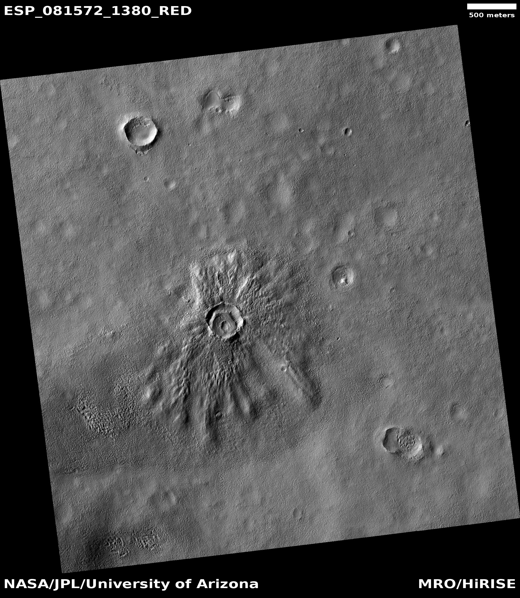
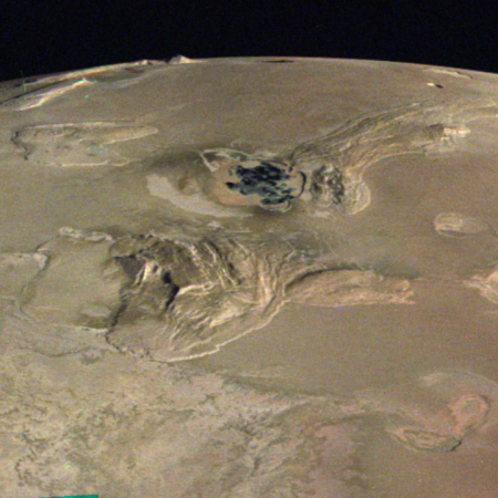
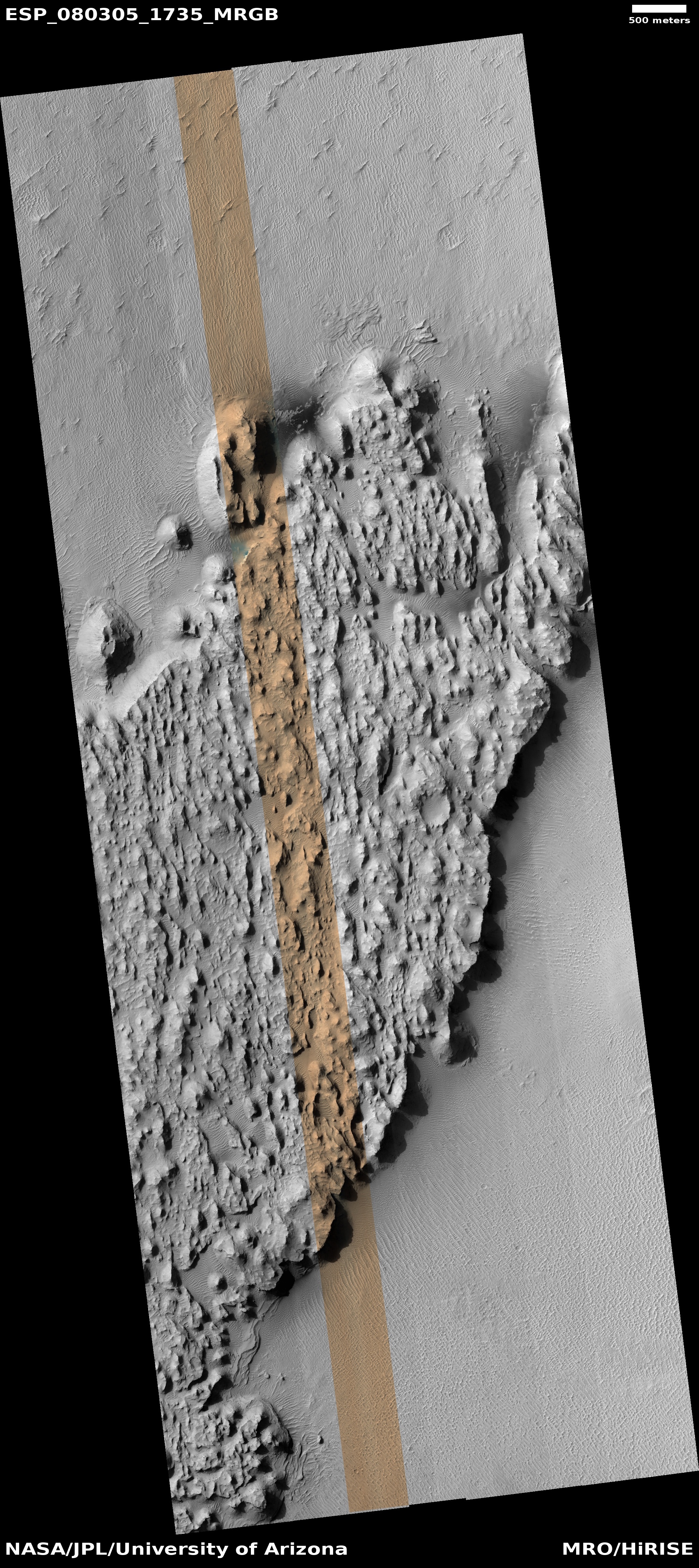
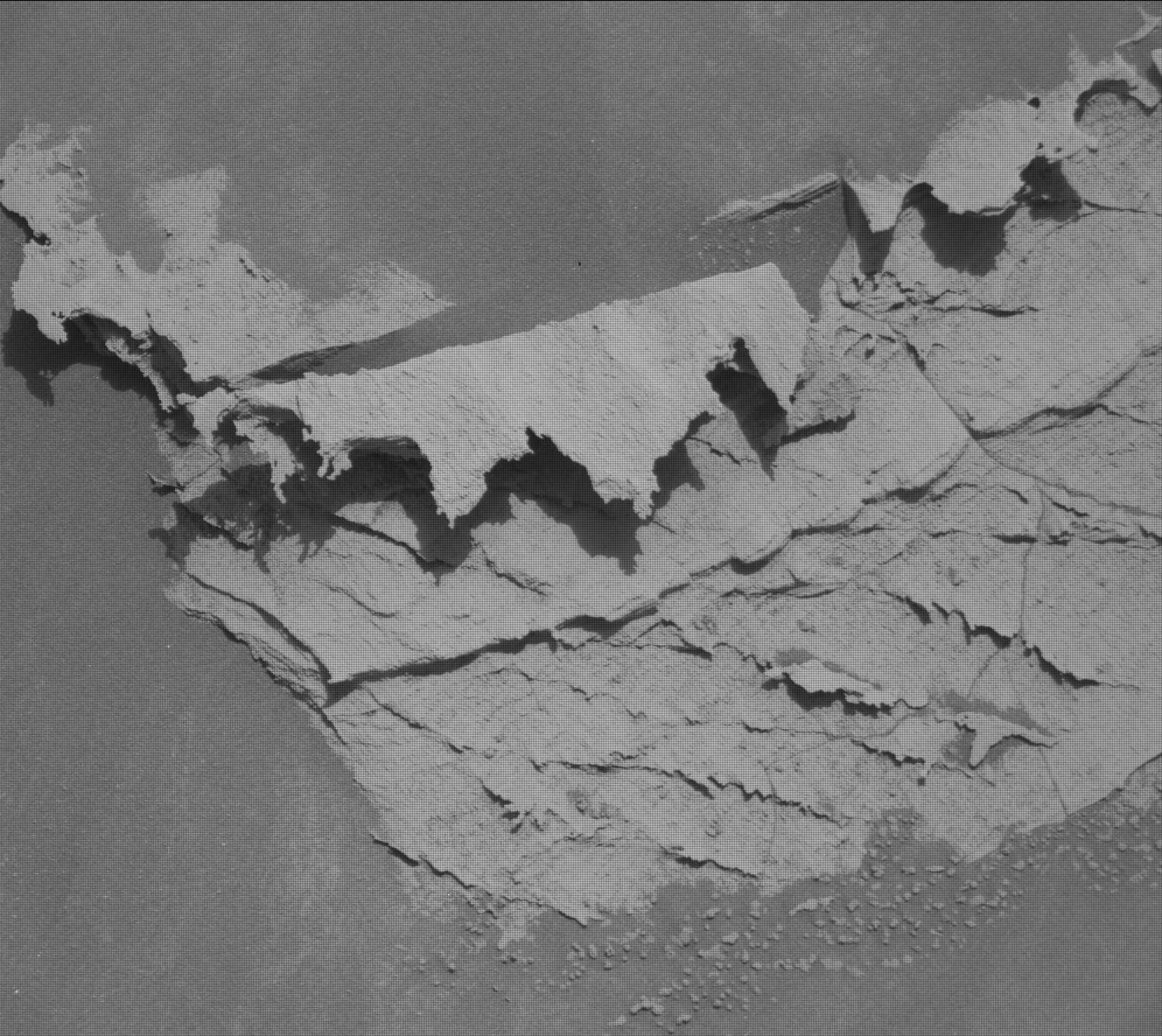
Cool image time! The picture to the right, rotated, cropped, reduced, and annotated to post here, was taken on September 21, 2021 by the high resolution camera on Mars Reconnaissance Orbiter (MRO) and shows what appear to be a variety of flows, from alluvial fill to slope streaks to dust coming down the southeastern interior rim of 77-mile-wide Orson Welles Crater on Mars.

The location is almost right on the equator, so none of these flows are ice- or water-related. Nor are such flows unusual in the meandering 800-mile-long canyon that cuts through Orson Wells crater, dubbed Shalbatana Vallis. I featured similar flows at a spot to the north and downstream from this one in May 2021, also on the canyon’s eastern rim.

The overview map below provides some context.
» Read more

Perseverance’s upcoming travel plans

Overview map
Click for interactive map.

Today’s update from the Perseverance’s science team provided a rough outline of their travel and drill-sampling plans for the Mars rover in Jezero Crater as it begins its climb up onto the delta that once poured into the crater. The route they plan to travel initially is dubbed Hawksbill Gap.

At Hawksbill Gap, however, we may instead carry out the first portion of the sampling sol path (which includes abrasion and collecting observations using our proximity science instruments) at up to 5 locations along our ascent. After that, we’ll turn around and begin a descent back down Hawksbill Gap and collect rock core samples at 3 of our abrasion locations.

This modified sampling strategy is intended to provide the team with valuable contextual information as we climb Hawksbill Gap and interpret the delta stratigraphy around us. With proximity science data in-hand, we can down-select our sampling sites to ensure we’ll be collecting the most scientifically valuable cores along our descent. Of course, we still maintain the option of collecting sample cores at any point during our ascent, if the team decides a particular abrasion site warrants immediate sampling.

The map above shows my guess (the red dotted lines) as to their potential routes uphill. As the science team has so far not published a map indicating exactly where Hawksbill Gap is, I can only guess at this point. The blue dot indicates Perseverance’s present position, the green dot Ingenuity.

As for the helicopter, there is no word yet whether the engineers have successfully gotten its batteries back to full charge. Until then, it cannot fly, and is also at risk of freezing up in the cold Martian winter.

Zhurong goes into hibernation

Overview map

According to a report today in China’s state-run press, the team running its Zhurong Mars rover have placed it into a hibernation mode in order to sit out the Martian winter.

To tackle the dust storms and low-temperature challenges, the Chinese rover went into dormancy on Wednesday. It is expected to wake up and resume work in December when the dust clears and Mars enters its spring season, the administration said in a statement.

The rover sits somewhere in the blue circle in the map to the right, created using elevation data and images from Mars Reconnaissance Orbiter (MRO). This region is about 25 degrees north latitude, so though it is in the dry equatorial regions of Mars, it still gets very cold in winter, down to -180 degrees Fahrenheit at night. Furthermore, the increased winter dust storms block the light from the Sun, which reduces the available power the rover’s solar panels can produce.

Chinese engineers have apparently adapted the hibernation techniques they use on the Moon with their Yutu-2 rover to place Zhurong in hibernation.

The tuffy ground in the foothills of Mount Sharp

Shelfstone on Mars?
Click for original image.

Cool image time! The photo to the right, reduced and enhanced to post here, was taken on May 13, 2022 by the high resolution camera on the rover Curiosity, looking down at some of the unusual features on the ground near the rover.

The lighter circular feature in the center is not natural, but created by Curiosity’s Dust Removal Tool (DRT). As explained on May 16th on the science team’s blog:

When that dust settles on rocks, it can partially mask the chemistry and surface texture of these rocks from APXS and MAHLI in particular [two other Curiosity instruments]. Brushing rock surfaces with the DRT is not always possible, but it does improve scientific assessments of these surfaces.

What attracted me to this photo was the tuff-like look of that uplifted flat rock. It looks just like many surfaces one sees in a cave, where the surface gets covered with calcite flowstone or popcorn, due to either water flow or condensation and then evaporation of calcite-saturated water on the surface. In this case the cave formation this flat rock most resembles visually is shelfstone, though the formation process and chemistry was certainly different. It does suggest strongly however that some form of water process occurred here.

InSight likely to shut down by the end of summer

Martian quake map as seen by InSight
Martian quake map as seen by InSight, adapted from this 2021
presentation [pdf]

According to the InSight science team, the Mars lander and its seismometer will likely shut down operations by the end of the summer due to lack of power.

“Towards the end of summer of ’22, we anticipate our seismometer will be turned off, not because we want to turn it off but unfortunately, we don’t have the energy to run it,” Garcia said. She said the team will use it intermittently after that as long as power is available, but by the end of the year the spacecraft is expected to fall silent.

The intermittent readings of the seismometer will be of extremely limited use, as it will then be pure luck whether it detects a quake, and any detection will not provide the true rate of quakes on Mars.

The loss of power is due to dust on the solar panels. The team had hoped a dust devil would come by periodically to blow the panels clean, as happened routinely with the Spirit and Opportunity rovers, but InSight has not been so lucky.

It appears the safe mode that occurred shortly after InSight detected its largest Mars quake yet on May 10th was very temporary, though right now the seismometer is essentially the only instrument they have power to run.

Overall, this mission has a very spotty history. Its launch was delayed two years when the French attempt to build the seismometer failed. The delay cost NASA’s planetary program $150 million, at a minimum.

Then lander’s second of two main instruments, a German experiment to dig down 16 feet to insert a heat sensor into the ground, failed when its digging tool, dubbed the mole, was unable to penetrate the alien Martian soil.

Fortunately, InSight’s prime instrument, the seismometer (finally completed by JPL) worked, giving us a first look into the structure of Mars’ interior as well as where earthquakes are found on its surface.

Mahma Comparisons – Biggest volcano eruptions known

An evening pause: I run this at 2x speed, but if you aren’t impatient enjoy it as it is. The size difference between the smallest and largest is quite daunting. Note too that this video only lists the known giant eruptions, explosive events that happened suddenly. It does not include some of the Earth’s largest long term volcanic events, such as the Deccan Traps, that happened repeatedly lasting millions of years that is thought to have possibly contributed to the extinction of the dinosaurs.

Hat tip Alton Blevins.

Pointy rocks on Mars

Pointy rocks as seen by Curiosity
Click for full image.

Pointy rocks as seen by Perseverance
Click for full image.

We have two cool images today from both of America’s rovers on Mars, each of which illustrates the alien nature of the red planet.

First on the right, cropped, reduced, and sharpened to post here, is a close-up taken by Curiosity’s high resolution camera on May 14, 2022 of the rightmost jagged boulder in yesterday’s navigation panorama. The number of layers is astonishing, though hardly a unique phenomenon as seen by Curiosity in its travels. Each likely marks one of many climate and geological cycles, each laying down another unique stratum for a relatively short period of geological time. Some might be volcanic ash or lava layers. Some might be layers caused by climatic changes.

The ability of these thin layers to extend outward so much, almost like they were floating, illustrates the weak Martian gravity, as well as the thinness of its atmosphere. On Earth, if the wind and weather didn’t cause these flakes to break, the gravity would.

Second on the right, cropped and sharpened to post here, is a high resolution photo taken by Perseverance on May 15, 2022 of one of the cliff faces seen by the rover looking up into the delta in Jezero Crater. Here again we see many layers and jagged, pointy rocks, illustrating again the many cycles in the past that formed the delta as it flowed into the crater.

The smoothness on the surface of the leftmost pointy rock suggests that it has stood in this position for a long very time, allowing the wind of Mars’ very thin atmosphere to erode its rough surface.

Curiosity climbs on!

Curiosity's view to the southeast, May 15, 2022 (Sol 3474)
Click for full resolution. Original images can be found here, here, and here.

Overview map
Click for interactive map.

Cool image time! The panorama above, created from three photos taken on May 15, 2022 by the right navigation camera on Curiosity, shows the rocky and hilly terrain directly ahead of the rover’s present course. In the far distance in the center left can faintly be seen the lower flanks of Mount Sharp itself. The dust in the winter air acts to partly obscure those distant slopes.

The overview map to the right shows us what we are looking at. The yellow lines are my rough guess at the terrain covered by the panorama. The blue dot marks Curiosity’s present position. The red dotted line the rover’s original planned route. The white arrows indicate one of the more interesting upcoming geological features, dubbed by scientists the “marker horizon,” a distinct layer found in many places on the flanks of Mount Sharp.

The green dot marks the approximate location of a recurring slope lineae, a place where the cliff is seasonally darkened by a streak that appears each spring and then fades.

The navigation panorama taken on May 15th also included four more shots covering terrain to the southwest, so what we see above is not necessarily where the rover is heading. The eventual goal is to get back to that red dotted line, but how the rover does so is apparently still being discussed by the science team. It appears they are trying to decide whether to head west again to reach Gediz Vallis Ridge, or instead cut south heading directly for Gediz Vallis.

Either way, that teethlike row of boulders in the near foreground is certainly impressive.

Scientists grow plants in lunar soil brought by from Apollo missions

In their first attempt, scientists have successfully grown plants in a small lunar soil sample brought by astronauts during the Apollo missions.

Researchers at the University of Florida had spent 11 years requesting permission from Nasa to borrow some of the lunar dust brought back by astronauts on the first manned Apollo 11 and Apollo 12 missions in 1969 and the Apollo 17 mission in 1972. Armstrong and Aldrin brought back 21.6kg of material including 50 rocks, samples of dust and two cores of rock after boring 13cm down into the Moon’s surface. They contained no water and no signs of life.

…The lunar samples are deemed to be of “incalculable historical and scientific significance”, so the scientists were given only 12 grams, just a few teaspoons’ full, to work with and had to design a miniature experiment.

The researchers used thimble-sized wells in a dish usually used for growing cells as miniature plant pots and filled each with about one gram of lunar soil. They moistened the soil with water and a solution of nutrients and added a small number of seeds from the Arabidopsis thaliana plant, a common flowering weed also known as mouse-ear or thale cress. [emphasis mine]

The plants grew, but were smaller and took longer to grow then plants on even the most extreme environments on Earth. The scientists also found that plants did better in buried lunar soil then the material on the surface that had been exposed to the harsh radiation of space, suggesting that plowing the soil before planting will enhance growth.

The highlighted words in the quote above illustrate the madness of NASA’s bureaucracy. These lunar samples were brought back so that scientists could study it, not so that it could be locked away in a vault forever never to be touched. To make this very intelligence experiment wait 11 years before getting permission is absurd.

Mountains, Mesas, and Box Canyons on the floor of Valles Marineris

Mountains, Mesas, and Box Canyons
Click for full image.

Overview map

Cool image time! The photo above, cropped, reduced, and rotated to post here, was taken on March 12, 2022 by the high resolution camera on Mars Reconnaissance Orbiter (MRO). It shows a small section of the floor of the giant 2,550-mile-long and 400-mile-wide Valles Marineris canyon on Mars. In fact, this section, as indicated by the black rectangle in the overview map below, is practically in the center of the canyon, at its widest point.

The geology here hints at several Martian processes. The mesas and closed canyons in the north are typical of chaos terrain, where it erosion appears to form along fault lines to create the random intersecting canyons. In other places on Mars, in the mid-latitudes, that erosion appears mostly formed by glacial activity. Here, in Valles Marineris at only 7 degrees north latitude, little ice had been expected.

However, this spot is also in the dead center of a region where orbital data from Europe’s Trace Gas Orbiter (TGO) suggests there is a surprisingly large underground reservoir of hydrogen, which is assumed could only exist if it was locked in water molecules.

In fact, at this spot the data suggests up to 40% of the near-surface material might be composed of water (by weight). If so, that underground reservoir of ice could be causing the erosion that is creating this massive chaos terrain.

Meanwhile, the light-colored mountain in the south is the westernmost nose of a 50-mile-long ridgeline coming down from the canyon’s rim, about 30,000 feet higher. Its dendritic nature, like the hollows that form in the mountains of wet regions on Earth, suggest rainfall and water flowing downhill, wearing away these hollows over eons.

Rain however is almost certainly not the cause. Instead, we could be seeing erosion from wind, or maybe dry ice snow that fell long ago when this region was at a higher latitude when Mars’ rotational tilt was different.

Either way, the massive geology here illustrates the monumental nature of this largest canyon in the solar system, as well as the difficulties of exploring it.

Scientists propose new theory to explain mysterious slope streaks on Mars

Slope streaks on Mars
Click for full image.

In a paper published earlier this month, scientists have proposed a new theory to explain the the origin of slope streaks on Mars, a unique Martian geological feature that at first glance look like a stainlike avalanches which also appear to do nothing to change the surface topography. (See earlier posts here and here for a description of this strange Martian phenomenon.)

Essentially, data from the orbiters suggests that carbon dioxide frost develops just under the surface during the night. In equatorial regions this frost mixes with dust (allowing it to exist even in these warmer climates). When the morning light hits the frost it causes it to sublimate away, which in turn causes the appearance of slope streaks as the dust is released from the frost.

From the paper’s abstract:

At sunrise, sublimation-driven winds within the regolith are occasionally strong enough to displace individual dust grains, initiating and sustaining dust avalanches on steep slopes, forming ground features known as slope streaks. This model suggests that the CO2 frost cycle is an active geomorphological agent at all latitudes and not just at high or polar latitudes, and possibly a key factor maintaining mobile dust reservoirs at the surface.

The cool image above, cropped and reduced to post here, was taken on October 28, 2020 by the high resolution camera on Mars Reconnaissance Orbiter (MRO) and shows an excellent example of two very spectacular large slope streaks, one long and narrow and another short and wide. Located at 23 degrees, this is an area where no ice has yet been found near the surface.

This new theory joins two other popular theories attempting to explain slope streaks. The others postulate that the streaks are either dust avalanches of a different type or the percolation of a brine of chloride and/or perchlorate in a thin layer several inches thick close to the surface.

None have been proven. None likely fit all the known data at this point.

InSight detects 5 magnitude Martian quake, the largest detected so far

The seismometer deployed by the Martian lander InSight has now detected its largest quake yet on Mars, with an estimated magnitude of 5.

NASA’s InSight Mars lander has detected the largest quake ever observed on another planet: an estimated magnitude 5 temblor that occurred on May 4, 2022, the 1,222nd Martian day, or sol, of the mission. This adds to the catalog of more than 1,313 quakes InSight has detected since landing on Mars in November 2018. The largest previously recorded quake was an estimated magnitude 4.2 detected Aug. 25, 2021.

The timing was very fortunate. Only three days later the power being generated by InSight’s dust-covered solar panels dropped too low, and the lander went into safe mode. Though its mission has been extended through the end of this year, the inability of the solar panels to produce energy because of dust has been predicted to shut down operations sooner. While it might be possible to restart science operations, this most recent safe mode situation could very well be that moment.

Meanwhile, scientists will analyze the data of this most recent large quake to attempt to pinpoint its location. They will also study it to gain a better understanding of the interior structure of Mars.

Curiosity climbing out of Gordon Notch hollow

Panorama showing the upcoming steep climb
Click for full image. For original images go here, here, here, here, and here.

Overview map
Click for interactive map.

Cool image time! The panorama above was created from five photos taken by Curiosity’s right navigation camera on May 4, 2022 as the rover worked its way upward out of Gordon Notch Hollow, the small valley it had left when it attempted to cross the Greenheugh Pediment to the west and was forced to retreat back into when engineers found the rough terrain on the pediment too much for the rover’s wheels.

The overview map to the right provides context. The blue dot marks Curiosity’s present position on Mars, on its 3,465 Sol since landing. The yellow lines mark the area viewed in the panorama, taken two Sols earlier. The red dotted line marks the original planned route, now abandoned. The white arrows indicate one of the more interesting upcoming geological features, dubbed by scientists the “marker horizon,” a distinct layer found in many places on the flanks of Mount Sharp.

On the panorama above the red dotted line is my guess as to the planned route out of Gordon Notch Hollow.
According to the science team’s most recent update on May 4th:
» Read more

Why a big Earth mountain would hardly be noticed on Mars

A big mountain lost on Mars
Click for full image.

Cool image time! The photo to the right, cropped and reduced to post here, was taken on February 13, 2022 by the high resolution camera on Mars Reconnaissance Orbiter (MRO). It shows a cliff escarpment that, based on a rough estimate of MRO’s elevation data, ranges from 10,000 to 13,000 feet high. Because the sun is only about 32 degrees above the western horizon, the shadows are long and distinct and bring out the features quite dramatically.

On Earth, a mountain 13,000 feet high would generally be named, because there are really not that many of them. If it was a cliff face dropping down into a canyon, which this Martian cliff is, it would be quite unique and probably be one of the most popular tourist spots on the globe. For comparison, the rim of the Grand Canyon in the national park, visited by millions, is only 4,000 to 6000 feet in elevation. This cliff on Mars is more than twice as deep, and yet, it is hardly the most spectacular canyon rim on the red planet.

The overview map below explains this.
» Read more

A quake south of Starship’s prime landing sites on Mars

The lowlands south of Starship's prime landing site
Click for full image.

Cool image time! The photo to the right, rotated, cropped, and reduced to post here, was taken on February 23, 2022 by the high resolution camera on Mars Reconnaissance Orbiter (MRO). Though it shows the largely featureless northern lowland plains of Mars, it is particularly interesting for two reasons.

First, according to the photo’s label this scarp/ridge is apparently near a quake detected by the seismometer placed on Mars by the lander InSight, located about a thousand miles to the southwest. Though no information of the strength of this quake is available, it is likely to have been a small and weak one, interesting mostly because it indicates some small underground instability or a recent small impact on the surface. The image favors the former, as it shows no obvious recent features of change. What it does show is one very intriguing flow feature draping the scarp. As the location is at 34 north latitude in a region where scientists have found a lot of evidence of water ice very close to the surface, the flow could very well be glacial in nature, though dismissing a lava origin would be a mistake.

The second reason this location is of interest is what lies relatively nearby, as shown in the overview map below.
» Read more

ESA: ExoMars will likely be delayed till ’28 at the soonest

An official of the European Space Agency (ESA) at a May 3rd science meeting announced that the launch of its ExoMars rover will likely be delayed until 2028 at the earliest because of the partnership breakup with Russia due to its invasion of the Ukraine.

Russia had been providing both the launch rocket as well as the lander on Mars.

Speaking at a May 3 meeting of NASA’s Mars Exploration Program Analysis Group (MEPAG), Jorge Vago, ExoMars project scientist at ESA, said he doubted a new lander could be ready by 2026. “It is theoretically possible, but in practice we think it would be very difficult to reconfigure ourselves and produce our own lander for 2026,” he said. “Realistically, we would be looking at a launch in 2028.”

Launching in 2028 could pose technical challenges for ExoMars. One trajectory would get the rover to Mars relatively quickly, but have it arrive just a month before dust storm seasons starts at the preferred landing site. An alternative trajectory would require traveling for more than two years to each Mars, but get the rover there six months before dust storms start.

“We have been trying very hard to convince the engineering team that the dust storm season is not death,” Vago said. “We should concentrate on making the rover more robust and able to weather a dust storm.”

There are other issues. The rover will need new radioisotope heating units, or RHUs, to provide power, since Russia will no longer providing them. If the U.S. provides, the launch for security reasons will have to take place in the U.S., which means the launch provider will have to be American.

The delay to ’28 also could cause the ExoMars rover mission to be completely changed, repurposed to become part of the sample return mission that the ESA and NASA are partnering to bring back the cached samples that Perseverance is gathering. If so, this repurposing might delay its launch to Mars even further.

Navigating a rover on Mars

16 photos taken by Perseverance's right navigation camera on May 2, 2022

Overview map
Click for interactive map.

Cool image time! The photo to the right is actually a screen capture of 16 consecutive photos taken on May 2, 2022 by the right navigation camera on the Mars rover Perseverance.

The overview map below gives the context. The red dot marks Perseverance’s position when the photos were taken. The green dot marks Ingenuity’s position. The small white dot marks the spot where the rover’s parachute landed. The yellow lines indicate I think the area covered by the sixteen navigation images.

There is a reason for showing this panorama in this somewhat crude form. The engineers who run Perseverance have programmed its navigation cameras to send back its pictures so that they immediately line up in this coherent pattern. There is no need to rearrange them upon arrival. The engineers thus can instantly see how each picture relates to the others, and thus get an immediate sense of the nearby terrain in which they must plot the rover’s next move.

Perseverance is now in its second science campaign, focused on studying the base of the delta. As the science team studies the delta’s cliff face, they are also studying the best route to continue uphill. To do both, they have begun slowly moving along that face, going from west to east.

The rough panorama above thus shows them the ground ahead as they continue that traverse. I expect the rover’s next move will be to the northeast, once again moving along the base of the nearest cliff. The panorama shows that while the ground in this area has a few ridges, none are so high as to cause Perseverance any problems.

Brain terrain in Mars’ glacier country

Brain terrain in glacier country
Click for full image.

Cool image time! The photo to the right, cropped and reduced to post here, was taken on February 10, 2022 by the high resolution camera on Mars Reconnaissance Orbiter (MRO).

It shows what planetary scientists have dubbed “brain terrain”, a truly unique Martian geological feature that is not found on Earth and also remains as yet unexplained. Specifically, the brain terrain is the speckled areas between the larger flow features, all of which are probably ice or glacier related.

What especially drew me to this MRO image however was the particular flow feature in the center left that looks like either a giant squid or something out of Lovecraft horror short story. Talk about a cool image!

The downward grade here is likely to the north, as this spot is inside a north-south canyon, cutting into the southern cratered highlands. The general north-south trend of the depression here reinforce this supposition.

The overview image below provides context.
» Read more

As Curiosity retreats from rough country, scientists look at the future geology it will see

Overview map
Click for interactive map.

Cool image time! For the past two weeks the Curiosity science team has been gingerly and slowing backing the rover off from the very rough terrain of the Greenheugh pediment, as shown on the overview map to the right. The blue dot indicates Curiosity’s present position, with the red dotted line marking its original planned route, now abandoned.

The main question remains: Where to go next? At this point the science team is still debating their exact path forward. As Catherine Weitz of the Planetary Science Institute explained to me in an email today,

The Curiosity team is still working out the details. Maybe in another month or so the new route will be finalized so stay tuned.

No matter what route they eventually choose, the white arrows mark one of the more interesting upcoming geological features that the scientists very much intend Curiosity to reach. In a paper published at the end of March in which Weitz was the lead author, they describe this “marker horizon” as follows:
» Read more

Dunes on Jupiter’s volcano moon Io?

Dunes on Io?
Click for full image.

The uncertainty of science: According to a just published paper, scientists now propose that the dune-like ridges long known to exist on Io, Jupiter’s volcano-covered moon, might actually be dunes, even though Io has no real atmosphere.

The photo to the right, cropped, reduced, and annotated to post here, was taken by the Galileo while it orbited Jupiter from 1995 to 2003. It illustrates what the scientists believe is the proposed process:

McDonald and his colleagues used mathematical equations to simulate the force required to move grains on Io and calculated the path those grains would take. The study simulated the movement of a single grain of basalt or frost, revealing that the interaction between flowing lava and sulfur dioxide beneath the moon’s surface creates venting that is dense and fast moving enough to form large dune-like features on the moon’s surface, according to the statement.

In what might be a monumental understatement about the reality of interplanetary geology, McDonald said this in the press release: “This work tells us that the environments in which dunes are found are considerably more varied than the classical, endless desert landscapes on parts of Earth.”

Damn right. The possibility of unexpected geology of all kinds on the millions of planets, moon, and asteroids not yet studied is endless, and guaranteed.

1 18 19 20 21 22 52