Perseverance spots its parachute

Perseverance spots its parachute
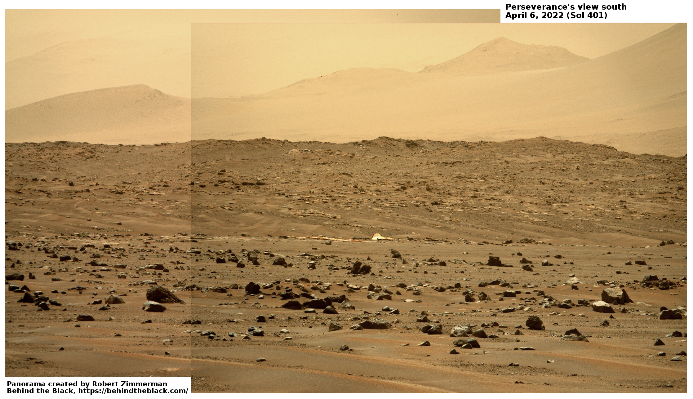
Click for full resolution. Original images found here and here.
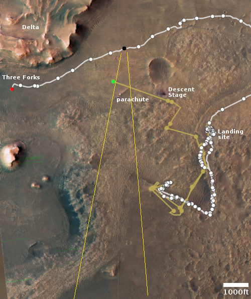
Overview map
Click for interactive map.

Cool image time! Today the Perseverance science team released two photos taken on April 6th that captured the parachute that the rover had used to land on Mars on February 18, 2021. The enhanced panorama above is from those images. The white feature near the center is the parachute. The mountains in the distance are the southern rim of Jezero Crater, about 40 miles away.

The overview map to the right gives the context. The red dot is Perserverance’s location as of yesterday, on sol 413. The black dot marks its location on April 6th, when it took the pictures. The green dot marks Ingenuity’s present position. The yellow lines indicate the approximate area covered by the panorama.

Ingenuity had not completed its 25th flight until April 8th, two days after these photos were taken, so it isn’t actually just off the edge of these photos, it is beyond the near ridgeline out of sight.
1 comment

Dawn on the Moon

Dawn on the Moon's far side
Click for full image.

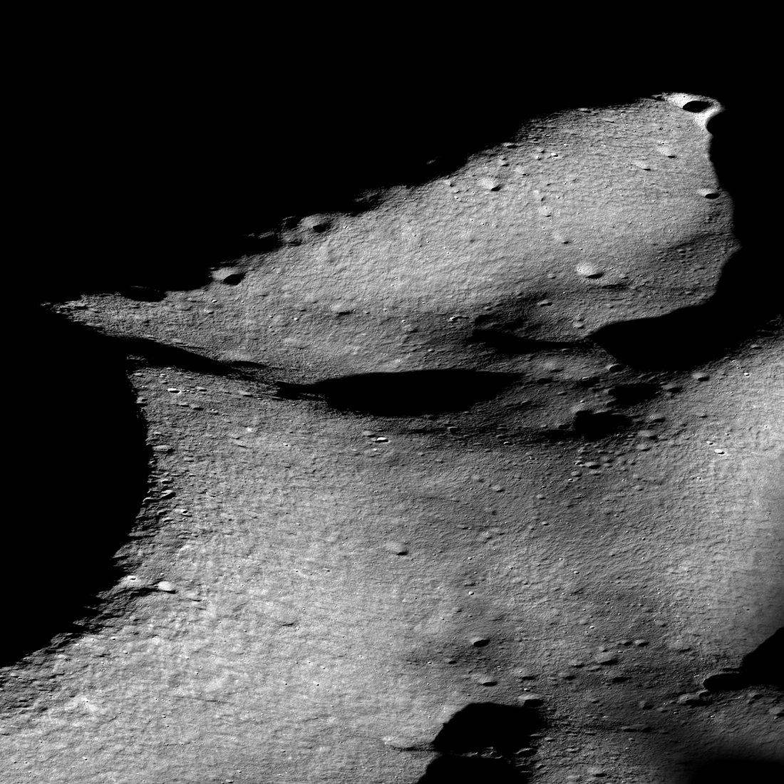
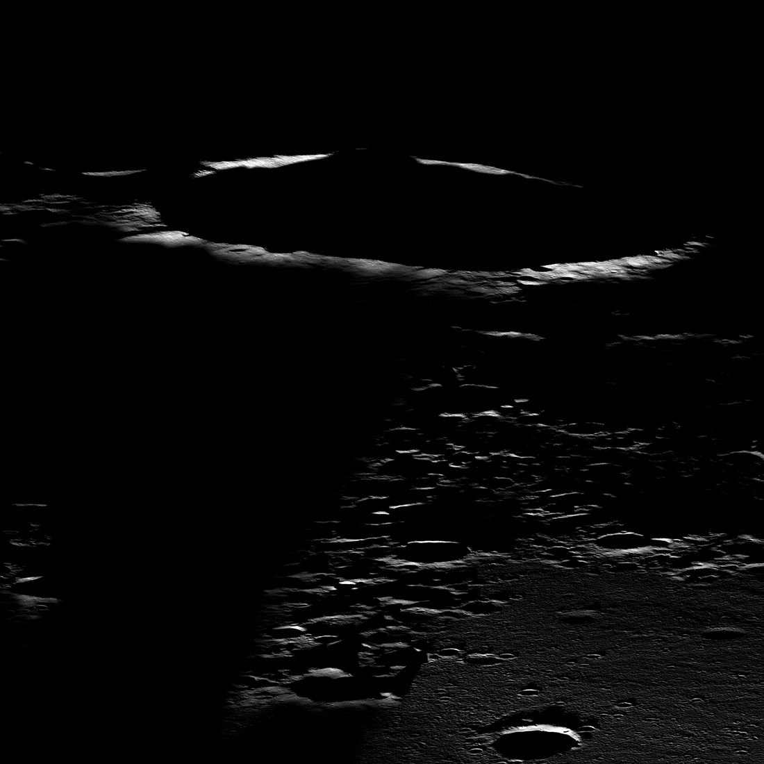
Cool image time! The photo to the right, reduced to post here, was taken on August 25, 2019 by Lunar Reconnaissance Orbiter (LRO). It shows an oblique view looking west just after lunar dawn of an unnamed 13-mile-wide crater in Mare Moscoviense on the far side of the Moon. From the caption:

Mare Moscoviense is one of the few volcanic plains on the farside, which is largely comprised of ancient cratered highland terrain. The fact that the farside was strikingly different from the familiar nearside was a surprise when the Soviet Luna 3 spacecraft returned the first farside images in 1959. The highland crust is thicker on the farside than on the nearside, which is thought to have inhibited magmas from reaching the surface as frequently as they once did on the nearside.

As seen in the image above, Mare Moscoviense lies within a large impact basin, the formation of which thinned the local crust, perhaps making it easier for lavas to erupt that would have otherwise stalled below the surface. But why does this global asymmetry in crustal thickness exist? This is still a mystery, like the origins of the large-scale asymmetries observed on Mars and Mercury, though ideas like a giant impact event that stripped off a portion of the crust or asymmetric overturn of the mantle have been proposed.

Note the dark shadow obscuring the foreground on the left. It appears from the topography in the overhead map at the link that the ridgeline that marks the eastern border of Mare Moscoviense is just high enough at dawn to keep the mare in shadow while allowing the sun’s dawn light to peek over and illuminate the crater’s rim. That ridgeline however only extends so far to the north, thus allowing sunlight to hit the plains on the right sooner.

3 comments

White sediment in Martian slot canyon

White sediment in Martian slot canyon
Click for full image.

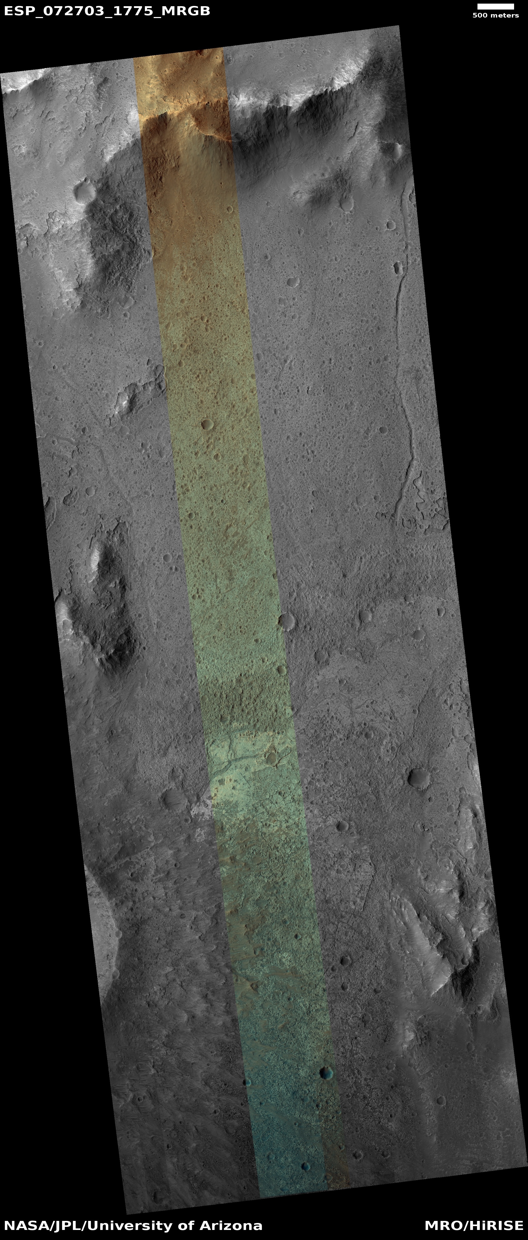
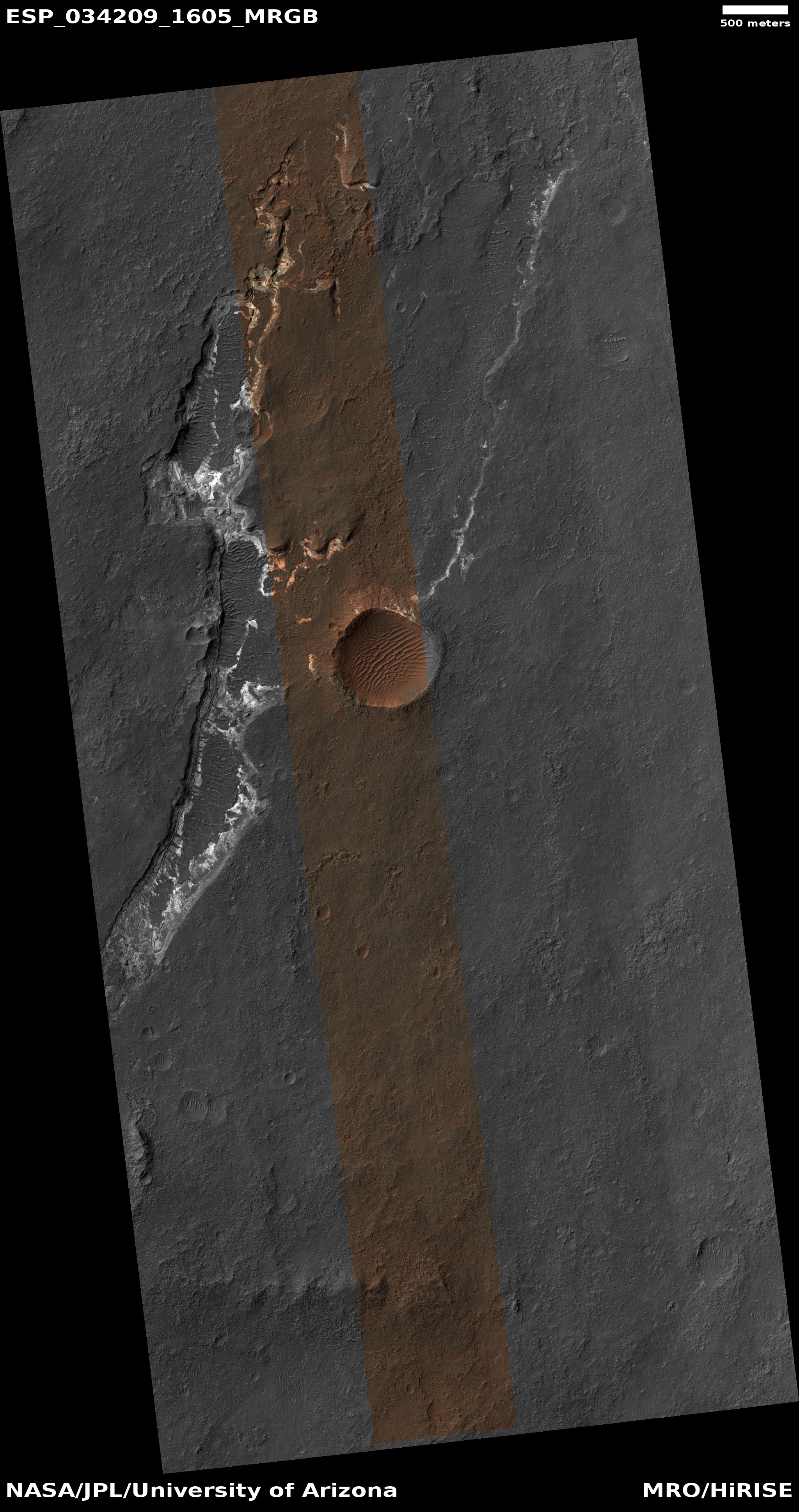
Yesterday’s Picture of the Day from the high resolution camera on Mars Reconnaissance Orbiter (MRO) revisited a captioned image first posted in February 2014 by the science team. That picture, cropped and enhanced, is to the right. From the 2014 caption:

There is a large channel system that flows into the basin, called Ladon Valles, and scientists think that the basin may have once filled with water before another channel to the north formed and drained it. These exposures of light-toned layered sediments provide clues about the environment that existed within Ladon Basin when water may have ponded and deposited these sediments.

Later research has generally concluded that these white sediments are iron and magnesium smectites, often appearing as white tuff material whose deposition is generally associated with precipitation of water or snow and its subsequent evaporation or sublimation.
» Read more

0 comments

Ingenuity completes 25th flight, the longest yet

Overview map
Click for interactive map.

On April 8th the Mars helicopter Ingenuity successfully completed its 25th flight on Mars, traveling 2,310 feet at 18 feet per second while flying for 161.3 seconds.

The long distance was designed to take it out from the rough region dubbed Seitah and near the delta that is the prime geological target of the rover Perseverance.

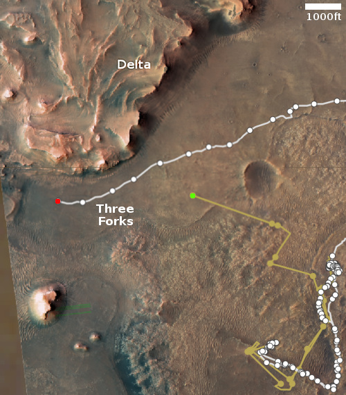
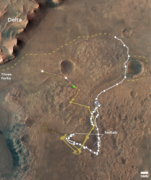
The overview map shows the location of both rover and helicopter as of today. The red dot is Perseverance, the green dot is Ingenuity. The rover has now completed its entire planned travels, as announced in June 2021. Where it goes next has not as yet not been announced. According to the team, they plan to use Ingenuity to scout out possibly routes up onto the delta. This likely means the rover will likely spend some time at the base of the delta, getting as much data as it can, while Ingenuity does this scouting work.

1 comment

The spread of the oceans’ sea floors appears to be slowing

The uncertainty of science: Based on data covering the last 19 million years, scientists now believe that the rate in which the Earth’s ocean sea floors are spreading has been slowing steadily.

Today, spreading rates top out around 140 millimeters per year, but peaked around 200 millimeters per year just 15 million years ago in some places, according to the new study. The study was published in the AGU journal Geophysical Research Letters, which publishes high-impact, short-format reports with immediate implications spanning all Earth and space sciences.

The slowdown is a global average, the result of varying spreading rates from ridge to ridge. The study examined 18 ridges, but took a particularly close look at the eastern Pacific, home to some of the globe’s fastest spreading ridges. Because these slowed greatly, some by nearly 100 millimeters per year slower compared to 19 million years ago, they dragged down the world’s average spreading rates.

You can read the actual paper here.

To put it mildly, the conclusion here is uncertain. The difference between 140 and 200 millimeters is less than two and a half inches. A hundred millimeters is less than four inches. Such small differences over millions of years could simple be caused by random fluctuations over time. Furthermore, the scientists did not actually detect the spreading rates from millions of years ago. They instead inferred it based on the data we do have of the changes in the Earth’s magnetic field over time.

Still, this result is very intriguing indeed. More than anything, it should help geologists develop better theories to explain plate tectonics, and what drives it. At the moment no theory adequate explains it.

7 comments

Frozen lava in Mars’ volcano country

The frozen lava of the Athabasca flood plain
Click for full image.

Cool image time! The photo to the right, cropped and reduced to post here, was taken on January 28, 2022 by the high resolution camera on Mars Reconnaissance Orbiter (MRO). It shows what appears to be at first glance a relatively featureless plain with a lighter material covered by a patchwork of darker material.

Note however the lack of craters. Except for several faint depressions near the image’s center, there are none. And those depressions look like the expression of craters that have been covered by material. Is the two-toned surface here an expression of past lava flows? Or are we seeing an ice-sheeted plain, with the patches representing higher terrain above that plain?

The overview map below answers the question somewhat clearly.
» Read more

0 comments

Curiosity retreating from Greenheugh Pediment

Overview map
Click for interactive map.

Because of the incredible roughness of the ground on the Greenheugh Pediment, the science team for the rover Curiosity has decided to make a major change in their route. Rather than continue their traverse across this terrain, as planned for years, they have decided to back off in order to protect Curiosity’s dinged wheels, and find a more friendly route up Mount Sharp.

“It was obvious from Curiosity’s photos that this would not be good for our wheels,” said Curiosity Project Manager Megan Lin of NASA’s Jet Propulsion Laboratory in Southern California, which leads the mission. “It would be slow going, and we wouldn’t have been able to implement rover-driving best practices.”

The gator-back rocks aren’t impassable – they just wouldn’t have been worth crossing, considering how difficult the path would be and how much they would age the rover’s wheels.

So the mission is mapping out a new course for the rover as it continues to explore Mount Sharp, a 3.4-mile-tall (5.5-kilometer-tall) mountain that Curiosity has been ascending since 2014. As it climbs, Curiosity is able to study different sedimentary layers that were shaped by water billions of years ago. These layers help scientists understand whether microscopic life could have survived in the ancient Martian environment.

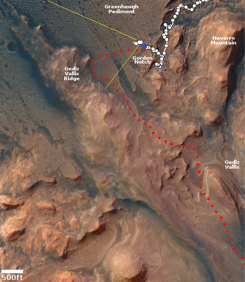
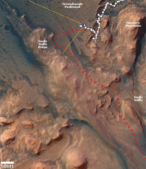
The plan is to retrace the rover’s path back through Gordon Notch and then head uphill though another gap that will take it directly onto the next sedimentary layer, dubbed the sulfate unit. On the overview map above, the red dotted line shows the long-planned route. The yellow lines indicate the area seen in the panorama I posted on April 6th, when Curiosity was at its farthest into the pediment. The blue dot marks Curiosity’s position two days ago. You can see that it has retreated backwards.

This change means the scientists will likely not get a close look at Gediz Vallis Ridge. However, it also means the rover will likely reach Gediz Vallis much sooner that previously planned.

0 comments

Perseverance arrives at Three Forks at the base of Jezero Crater’s delta

Panorama of delta in Jezero Crater
Original images found here, here, here, and here. Click for full resolution.

Overview map
Click for interactive map.

Cool image time! The panorama above was created from four navigation camera images taken by the Mars rover Perseverance on April 10th. Because the lens on Perseverance’s navigation cameras produce slightly curved images which are taken in pairs, the panorama is made of two parts, each a pair perfectly matched images looking from a different angle. I have overlapped the pairs but as you can see, the match at the center is imperfect. While this does not produce a single smooth image, the two paired panoramas show the foot of the entire delta that had flowed into Jezero crater in the past and is the prime geological target of the rover. What is it made of? What caused it to flow into the crater? When did it do it? How was Mars different when it did so? Was the crater wet? Was the delta mud when it flowed, or was it sediment under water, pushed out by that flowing water?

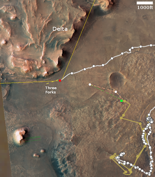
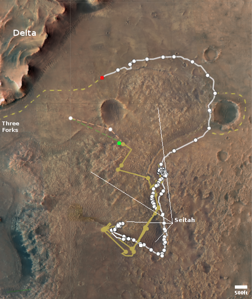
The location map to the right is taken from the “Where is Perseverance?” webpage but annotated to show the planned routes of both Perseverance and Ingenuity, as shown by the tan dashed lines. The red dot marks Perseverance present location, the green dot Ingenuty’s. The yellow lines the approximate area covered by the panorama.

What next? Expect Perseverance to move as close to the base of the delta’s cliff as possible and spend at least several months studying it. Ingenuity meanwhile will be flown to the west to scout the various hollows that are potential routes for Perseverance to climb up onto the delta.

0 comments

Splonk went the crater!

Splonk went the crater!
Click for full image.

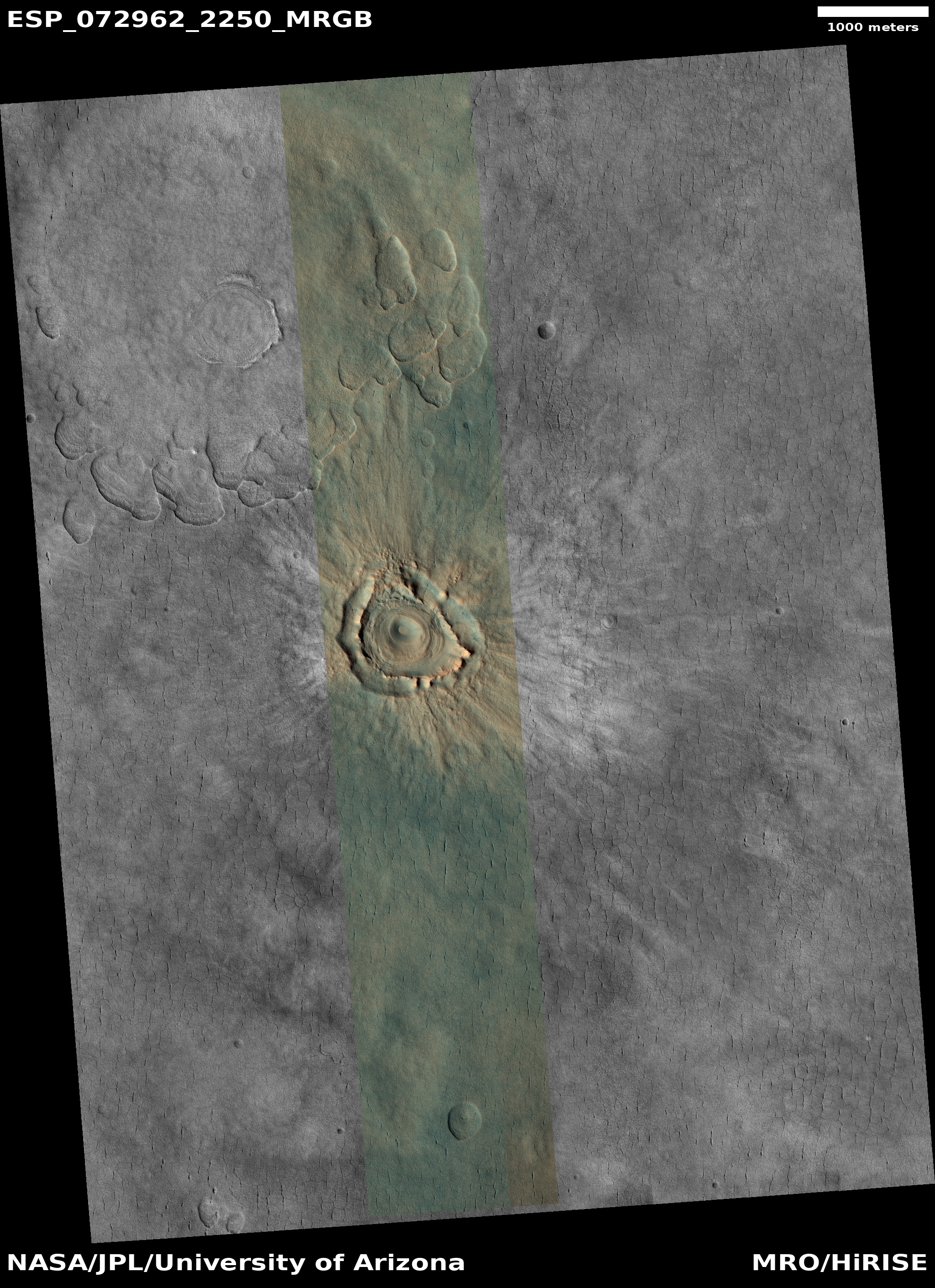
Cool image time! The photo to the right, cropped and reduced to post here, was taken on February 18, 2022 by the high resolution camera on Mars Reconnaissance Orbiter (MRO). It shows what the scientists label as a “degraded crater in Utopia Planitia.”

There is a lot of intriguing geology in this one image. First of course is the crater itself. We have to ask, is it from an impact or from some volcanic process? The location, at 44 degrees north latitude, argues that some form of ice or mud process was involved. Maybe we are looking at a frozen eruption from an underground ice layer. If this was instead caused by an impact, the crater’s ringlike structure could have been created by the ripples of melted ice and mud emanating away but then quickly refreezing.

Surrounding the crater are many small fissures, the largest ones all oriented in a north-south direction. If there is an ice layer near the surface, these cracks might be caused by that ice sublimating away. Why the largest cracks orient in the same direction however is a mystery.

The color variations suggest [pdf] dust (red-orange) as well as a variety of minerals (green). Since no blue appears visible in this version of the photo, if this crater was shaped by melting or erupting ice, that ice is well covered by that layer of dust and debris.

The location map below as always provides context.
» Read more

2 comments

Curiosity’s upcoming rough terrain

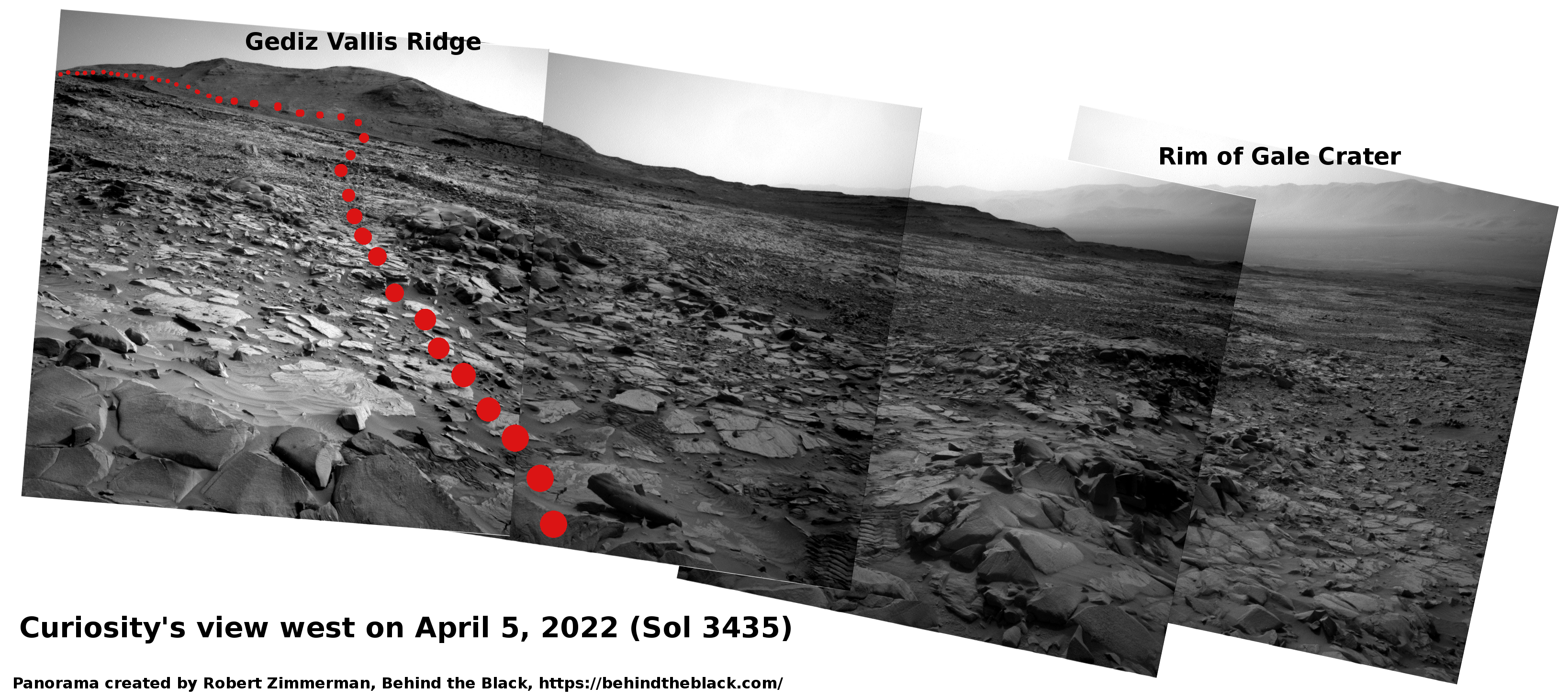
Curiosity's view looking west on April 5, 2022 (Sol 3435)Click for high resolution. For original images go here, here, here, and here.

Overview map
Click for interactive map.

Cool image time! The panorama above, created by me from four photos taken by Curiosity’s right navigation camera on April 5, 2022, reveal much about the alien world of Mars that the rover is exploring. The red dotted line indicates approximately the rover’s upcoming route.

First there is the rough surface of the Greenheugh Pediment, the sloping plateau that Curiosity is presently traversing. Called “gater-back terrain” by the science team, this broken surface apparently is sandstone that was originally a dune field that in the past was periodically washed by water runoff and later hardened into this structurally weak rock.

Second, I have orientated the images so that the rim of Gale Crater, approximately 25 miles away, is horizontal. By doing so, we can see the upward slope of the Greenheugh Pediment. Curiosity is on a tilted surface, and while it will be traversing along a contour line as it heads west towards Gediz Vallis Ridge about 1,000 feet away, when it turns left and heads uphill, the climb will be steady and steep, as it has now been for the past year since the rover entered the mountains at the foot of Mount Sharp.

Taken together, these details indicate why Curiosity has moved very slowly in recent weeks, as shown by the white dots in the overview map to the right. The blue dot marks Curiosity’s present location, with the yellow lines indicate the approximate view in the panorama above.

Traversing the pediment carries real risk to the rover. Though its somewhat dinged wheels have held up well during this last year of traveling in these rough mountains, at any point the severe roughness here could damage one or more wheels significantly, even putting one or more out of commission. The rover team is traveling carefully to avoid this, but these factors illustrate a possible end for the rover, though hopefully still years away.

0 comments

Inspector General: NASA’s lunar rover VIPER mission on schedule, with some cost increases

VIPER's planned route on the Moon

According to a report [pdf] issued today by NASA’s inspector general, the agency’s VIPER lunar rover mission is generally on schedule for its ’23 launch, though it has experienced some cost increases and still carries some scheduling risks, mostly related to the development of Astrobotic’s commercial Griffin lunar lander, and its precursor Peregrine mission that ULA hopes to launch on its first Vulcan rocket test.

Although Astrobotic personnel explained that Griffin’s development schedule is largely independent of its Peregrine mission, the Peregrine Lander—planned to launch in 2022—has multiple systems and subsystems that will also be used on Griffin. Therefore, any technical problems with these systems may adversely affect development of the Griffin Lander because Astrobotic would only have about a year, depending on the Peregrine launch date and start of lunar operations, to resolve the issues prior to NASA delivering VIPER for integration and launch. Furthermore, any failures during the Peregrine mission may lead to Griffin delays as NASA and Astrobotic investigate the failures and develop corrective actions.

In addition, VIPER long-lead acquisitions—such as the rover solar power array and avionics unit—have been affected by aerospace industry supply chain delays caused by COVID-19 as have delivery of computer boards and motor parts. Both of these issues have impacted design verification testing needed for the mission’s Critical Design Review, while COVID-19 also delayed some component development schedules.

Peregrine’s launch has been delayed by a year because Vulcan has been delayed because of Blue Origin’s problems with the BE-4 rocket engine. Though ULA hopes the Vulcan/Peregrine launch can occur late this year, that date remains very much in doubt. Further launch delays would thus threaten the launch of Griffin and VIPER.

As for the cost increases, the IG found that NASA had been forced to increase the budget for VIPER by 18.1%, a relatively minor increase compared to many of NASA’s other big projects. The IG noted however that further cost overruns are very possible, especially if the Peregrine mission experiences problems.

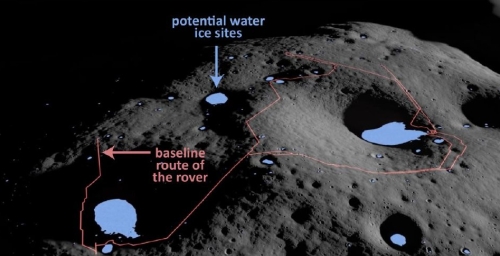
The photo above shows the rover’s presently planned route in the relatively flat area about 85 miles from the Moon’s south pole and near the western edge of Nobile Crater (pronounced No-BEEL-e).

1 comment

Ingenuity completes its 24th flight on Mars

Overview map
Click for interactive map.

Ingenuity today completed its 24th flight on Mars, traveling a short 33 feet for 69.5 seconds in order to place it in a good position for an upcoming record-setting 25th flight.

With Flight 24 in our log book, it is now time to look forward to our upcoming effort that charts a course out of Séítah. Flight 25 – which was uplinked yesterday – will send Ingenuity 704 meters to the northwest (almost 80 meters longer than the current record – Flight 9). The helicopter’s ground speed will be about 5.5 meters per second (another record) and we expect to be in the rarefied Martian air for about 161.5 seconds.

The red dot on the map to the right indicates Perseverance’s present position. The green dot shows where Ingenuity landed today. The tan dashed lines indicate the planned routes for both. Ingenuity’s next flight will take it out of the rough terrain of Seitah and much closer to Three Forks.

0 comments

The most valuable real estate on the Moon

The most valuable real estate on the Moon
Click for full image.

Cool image time! The photo to the right, reduced and annotated to post here, is an oblique view of the terrain near Shackelton Crater and the Moon’s south pole, taken by Lunar Reconnaissance Orbiter (LRO) and released today.

Shackleton-de Gerlache ridge, about 9 miles long, is considered one of the prime landing sites for both a manned Artemis mission as well as the unmanned Nova-C lander from the commercial company Intuitive Machines. To facilitate planning, scientists have created a very detailed geomorphic map [pdf] of this region. As explained at the first link above,

Going back to time-proven traditions of the Apollo missions, geomorphic maps at a very large scale are needed to effectively guide and inform landing site selection, traverse planning, and in-situ landscape interpretation by rovers and astronauts. We assembled a geomorphic map covering a candidate landing site on the Shackleton-de Gerlache-ridge and the adjacent rim of Shackleton crater. The map was derived from one meter per pixel NAC image mosaics and five meters per pixel digital elevation models (DEM) from Lunar Orbiter Laser Altimeter (LOLA) ranging measurements.

Such geology maps guide planning and exploration, but actual images tell us what the first explorers will see. Below is a close-up overhead view of small area at the intersection of the ridge and the rim of Shackleton.
» Read more

5 comments

Strange terrain at the Martian equator

Strange terrain at the Martian equator
Click for full image.

Cool image time! The photo to the right, cropped to post here, was taken on January 29, 2022 by the high resolution camera of Mars Reconnaissance Orbiter (MRO). It shows a small portion of the floor of 41-mile-wide Tuskegee Crater, sitting at the Martian equator on the rim of the outlet to the giant canyon Valles Marineris.

I have purposely focused on a section of the color strip, because of its strange green color. Most MRO images are reddish (indicating dust) or blue (indicating coarse rocks or ice). Green seems to me to be rare, and in fact is not even mentioned in the MRO science’s team explanation [pdf] of the colors the instrument produces. Since green is neither dust nor ice, this suggests some form of hard bedrock, with a mineralogy that produces that color.

The overview map below gives some context.
» Read more

4 comments

A large Martian river basin with delta

Map of Hypanis Valles river basin on Mars
Click for full image.

Cool map time! The map to the right, reduced to post here, is figure 1 in a new paper outlining the known geology of what appears to be a large ancient and now dry river basin with delta on Mars, found north of Valles Marineris and draining into the northern lowland plain dubbed Chryse Planitia where both Viking-1 and Mars Pathfinder landed, in 1976 and 1997 respectively.

The river basin itself is called Hypanis Valles. The white splotch at the river basin’s outlet is dubbed the Hypanis Deposit, and is thought by some scientists to be a delta of material that was placed there when the river was active 3.6 billion years ago and poured into what some scientists believe was an intermittent ocean in Chryse Planitia. From the paper’s conclusion:

As proposed in prior works, Hypanis may have formed subaqueously as a delta, and may record a water level drop of about 500 m[eters, or about 1,600 feet] as a shoreline retreated to the northeast. We identified kilometer-sized cones and mounds which appear to have erupted onto the surface. Characteristics of these features more closely resemble those of outgassing, sedimentary diapirism, and mud volcanism rather than of igneous volcanism.

The intermittent ocean theory has problems however. For this delta to have formed underwater that ocean would have to have been much much larger than estimated based on the present known data, extending out to cover almost all of Chryse Planitia, in some places to a very great depth.

Some scientists have hypothesized that the ocean need not have been that large because a land dam would have confined it to a smaller region at the river’s outlet. This research however found no evidence of such a dam. However, the paper also noted that “Further work could examine the role of ice or glaciers in the formation of Hypanis and determine if an ice dam would be plausible.”

And of course there remains the more fundamental mystery of liquid water on the Martian surface, which makes the river basin itself a puzzle. No generally accepted model allowing for surface liquid water on Mars presently exists. The possibility that ice and glaciers could have done the job comes to mind again. Though the geology in this region reveals what looks like to our Earth eyes to be a very large river system, now dry, this is not Earth but an alien planet. Tributary systems like this might form from different and as yet not understood processes on Mars, some of which might involve glaciers.

0 comments

Active volcanoes on Pluto?

Elevation map of Wright Mons on Pluto

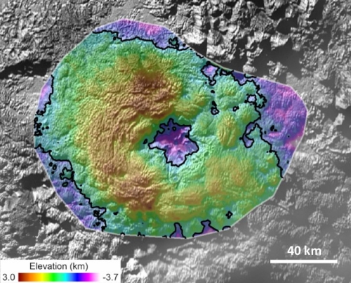
The uncertainty of science: According to new research published yesterday, scientists now posit that there might be recent volcanic activity on Pluto, based on data and images sent back by New Horizons during its fly-by of the planet in 2015.

You can read the paper here. From its abstract:

The New Horizons spacecraft returned images and compositional data showing that terrains on Pluto span a variety of ages, ranging from relatively ancient, heavily cratered areas to very young surfaces with few-to-no impact craters. One of the regions with very few impact craters is dominated by enormous rises with hummocky flanks. Similar features do not exist anywhere else in the imaged solar system. Here we analyze the geomorphology and composition of the features and conclude this region was resurfaced by cryovolcanic processes, of a type and scale so far unique to Pluto. Creation of this terrain requires multiple eruption sites and a large volume of material (>104 km3) to form what we propose are multiple, several-km-high domes, some of which merge to form more complex planforms. The existence of these massive features suggests Pluto’s interior structure and evolution allows for either enhanced retention of heat or more heat overall than was anticipated before New Horizons, which permitted mobilization of water-ice-rich materials late in Pluto’s history. [emphasis mine]

The image to above is Figure 10 in the paper’s supplementary material [pdf]. It shows the volcano-like appearance of Wright Mons on Pluto, a mound approximately 3,000 feet high with a central depression equally deep, with a volume “similar in magnitude to that of the Hawaiian volcano Mauna Loa.”

These conclusions are quite tantalizing, but the amount of data is sparse, and thus it is wise not to take them too seriously. For example, the scientists have no idea how Pluto could presently have any form of liquid or active volcanism. Another mission to Pluto — studying it over a long time from orbit — will be required to determine how active the planet really is, or if it is active at all.

2 comments

Scientists: Ice layers in Burroughs Crater confirm Martian orbital climate cycles

Layering in the west side of Burroughs Crater
Click for full image.

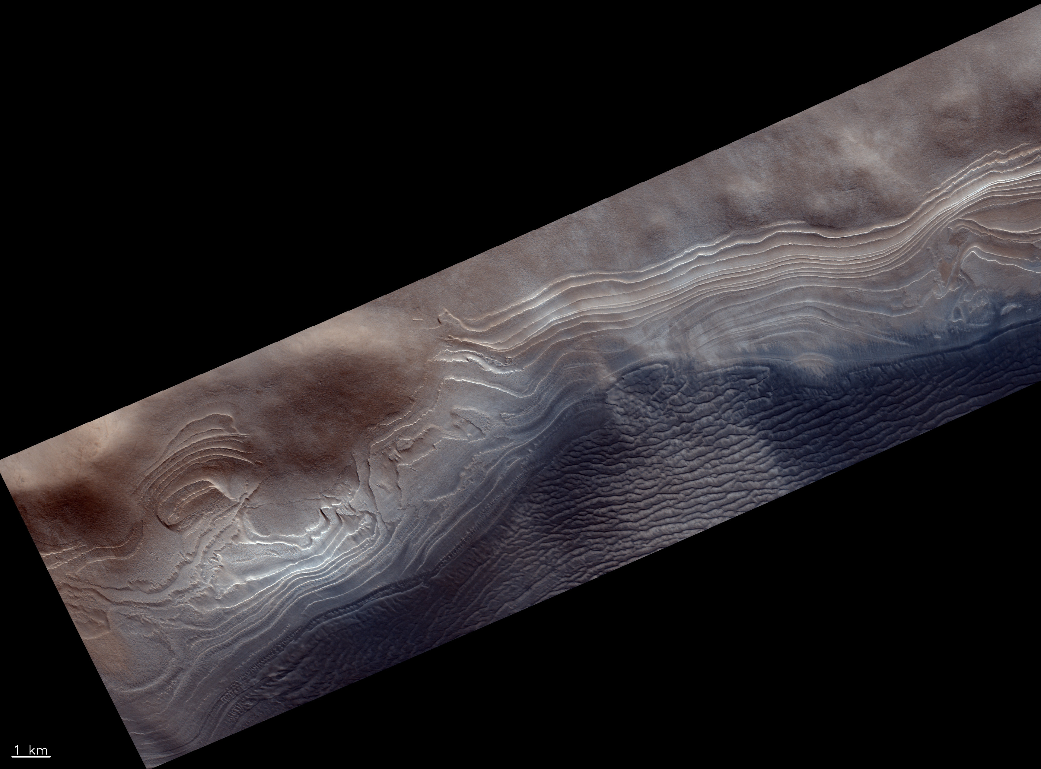
According to a new paper published today, scientists have used the ice layers inside Burroughs Crater on Mars to confirm the theory that the Red Planet has undergone numerous climate cycles during the past four million years, caused by the swings in the planet’s rotational tilt and eccentric orbit. From the press release:

Previously, Martian climate scientists have focused on polar ice caps, which span hundreds of kilometers. But these deposits are old and may have lost ice over time, losing fine details that are necessary to confidently establish connections between the planet’s orientation and motion and its climate.

Sori and his colleagues turned to ice mounds in craters, just tens of kilometers wide but much fresher and potentially less complicated. After scouring much of the southern hemisphere, they pinpointed Burroughs crater, 74 kilometers wide, that has “exceptionally well-preserved” layers visible from NASA HiRISE [Mars Reconnaissance Orbiter’s high resolution camera] imagery, Sori said.

The researchers analyzed the layers’ thicknesses and shapes and found they had strikingly similar patterns to two important Martian orbital dynamics, the tilt of Mars’ axis and orbital precession, over the last 4 to 5 million years.

The photo above of those layers was taken by Europe’s Trace Gas Orbiter on March 13, 2019, cropped and reduced to post here.

This research greatly strengthens the theory that the ice on Mars gets distributed to different latitudes in cycles, depending on the cyclical fluctuations in the planet’s orbit and tilt. However, it does not yet confirm these cycles apply to the glaciers found in craters in lower latitudes. Burroughs Crater is at 72 degrees south latitude, near the southern polar ice cap, well south of the band of glaciers scientists have discovered in the mid-latitudes down to 30 degrees latitude. Nonetheless, this research strongly suggest the same cycles apply in those lower latitudes.

5 comments

Ice sheets on Mars below 30 degrees latitude?

Cracks in Ice on Mars?
Click for full image.

Cool image time! The photo to the right, cropped and reduced to post here, was taken on November 29, 2021 by the high resolution camera on Mars Reconnaissance Orbiter (MRO). It shows a collection of scattered thin surface fractures, grouped in clusters of parallel lines with the orientation of the clusters all somewhat random to other clusters.

The fractures, as well as the material inside the craters, appears to resemble glacial features, suggesting that these fractures are the result of either the past motion of the glacial sheet, or the sublimation of the buried ice, which causes it to crack and shrink as it slowly dissipates away.

The problem with that hypothesis is the location, as shown by the overview map below.
» Read more

0 comments

Curiosity presently traveling over broken sandstone from an ancient dune field

Gator-back terrain on Mars
Click for full image.

According to a new paper, scientists now think that the rough and broken cap layer of the Greenheugh pediment that Curiosity is presently traveling across was originally a dune field periodically washed by water runoff, which with time eventually hardened into sandstone.

That broken terrain, dubbed “gator-back terrain” by the Curiosity science team, is shown clearly in the image to the right, taken on March 20, 2022. From the paper’s abstract:

The Greenheugh pediment is capped by a unit of broadly uniform thickness which represents the remains of the Stimson dune field that existed <2.5 Ga (mid- to late-Hesperian). ChemCam geochemical data shows that the sands deposited at the Greenheugh capping unit were sourced from a nearby olivine-rich unit. Surface waters then cemented the windblown sand deposits, ponding at the unconformity with the underlying mudstone unit, creating concretions towards the base. Episodes of groundwater circulation did not affect the rocks at Greenheugh as much as they did at other Stimson localities with the exception of acid-sulfate alteration that occurred along the unconformity. These results suggest that the ancient Stimson dune field was a dynamic environment, incorporating grains from the surrounding geological units on Mt Sharp. Furthermore, liquid water was stable at the surface in the Hesperian and was available for multiple diagenetic events along bedrock weaknesses.

In other words, material from Mount Sharp formed the dune fields, all of which were reshaped by groundwater circulation, with the dunes higher on the mountain seeing less groundwater.

The biggest uncertainty of these findings is explaining how surface liquid water could exist on Mars. Scientists have yet to develop an accepted model that would allow it. Another possibility would be the recent data that suggests Gale Crater was filled with glaciers. If so, scientists would need to figure out how the interaction of a Martian glacier might have geologically changed those dunes in a manner similar to groundwater.

2 comments

Ingenuity completes 23rd flight on Mars

Overview map
Click for interactive map.

JPL announced tonight in a tweet that Ingenuity today completed its 23rd successful flight on Mars.

23 flights and counting! #MarsHelicopter successfully completed its 23rd excursion. It flew for 129.1 seconds over 358 meters [1,175 feet].

The overview map to the right was taken from the “Where is Perseverance?” webpage and annotated by me to show the planned future routes of both Perseverance and Ingenuity. The white dotted line shows Perseverance’s path, now having almost circled the rough ground on its way to the delta and Three Forks. The tan dotted line indicates Perseverance’s future route. The dashed pink and green lines indicate two possible future flight paths for Ingenuity.

The green dot marks the position the science team marked on the map for where Ingenuity landed after today’s flight. They have not yet calculated the actual flight path, which is why it is shown by the tan dashed line. This also means there is as yet some uncertainty about this landing spot.

Originally, the plan had been to get to this spot in one flight. For reasons not yet explained, when the helicopter took off on its 22nd flight during the March 19-20th weekend, it stopped after only about 100 feet. Today’s flight apparently completed the plan, putting the helicopter where it was supposed to be.

3 comments
1 46 47 48 49 50 95