Mars Reconnaissance Orbiter spots Opportunity through dust

Mars Reconnaissance Orbiter has taken a picture through the fading Martian dust storm that spots Opportunity about halfway down Perseverance Valley in the rim of Endeavour Crater.

Engineers have been increasing the number of times per day they are attempting to communicate with the rover, so far all to no avail. The picture thus only really tells us that the storm is lifting and that MRO’s high resolution camera is operating normally after three months of limited picture taking because of the dust storm.

0 comments

A Martian shoreline?

Collapsing cliff in Tempe Fossae

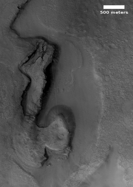
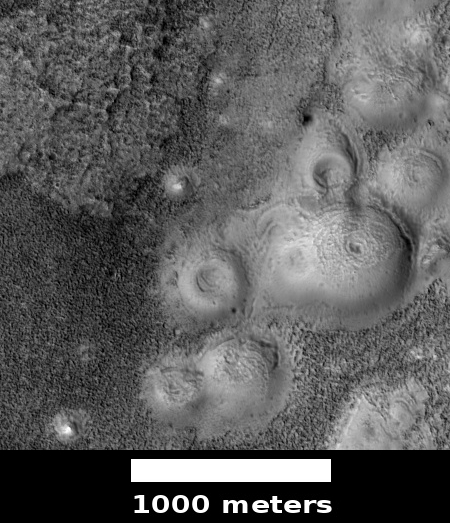
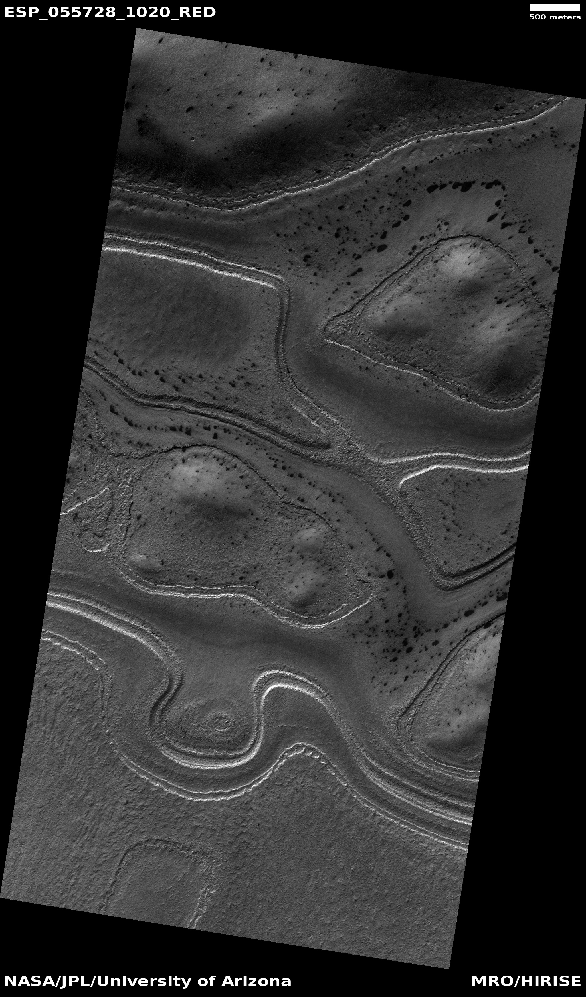
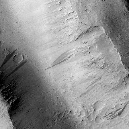
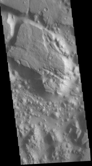
Cool image time! The image on the right, reduced and cropped to post here, was part of the August 31 image release from the high resolution camera of Mars Reconnaissance Orbiter (MRO). (Click on the image to see the full image.) It shows a slowly separating cliff feature in a region dubbed Tempe Fossae

As part of that monthly mass release, no caption was provided for this image. However, we can gain some understanding by looking at the larger context.

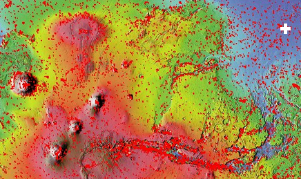
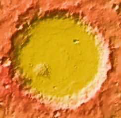
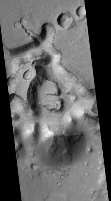
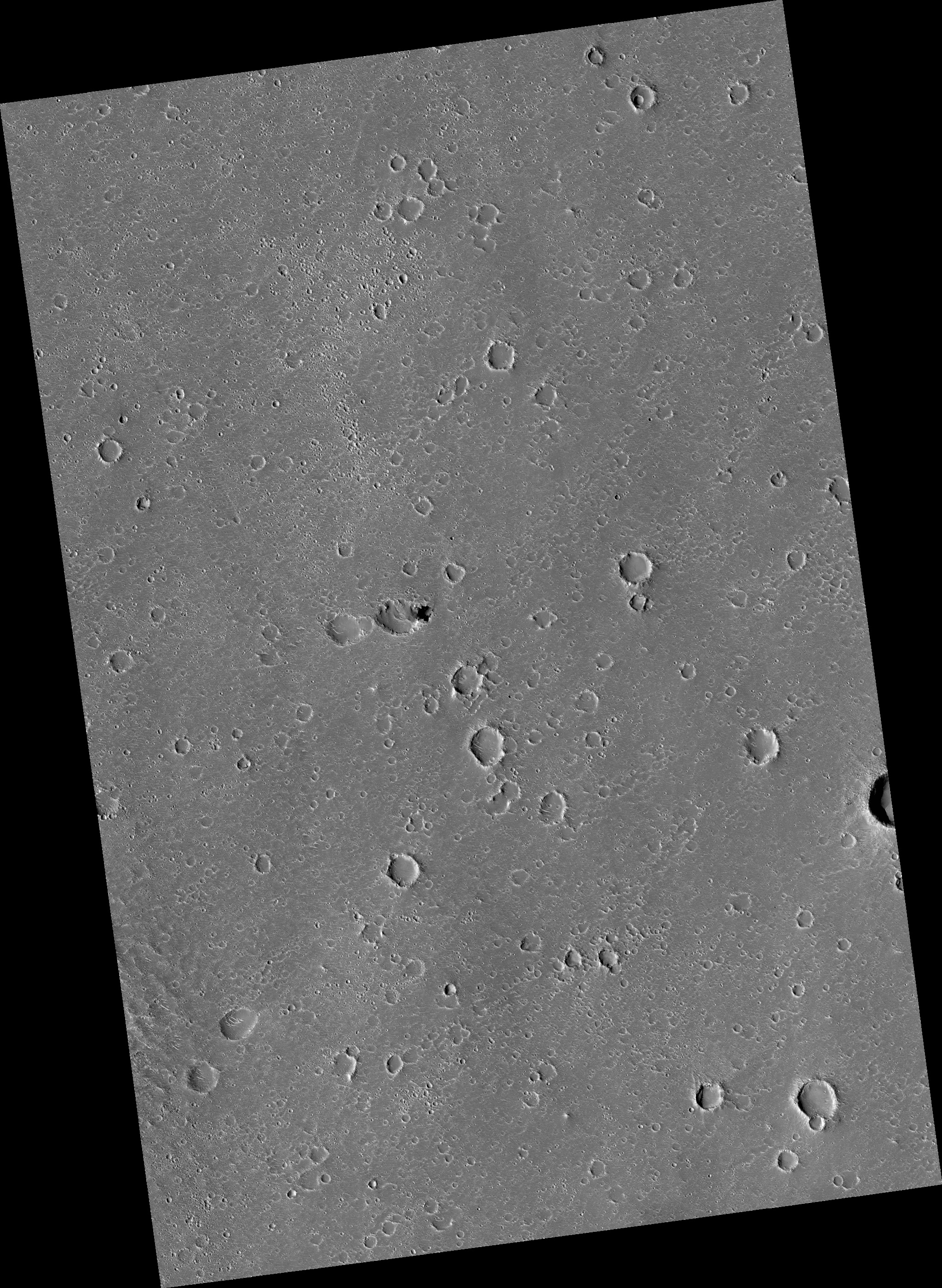
Tempe Fossae is located at the margins between the low flat northern plains and the high southern highlands. The location is also part of the vast drainage region to the east of Mars’ gigantic volcanoes. This is obvious from the overview image below and on the right. The location of this image is indicated by the white cross.

Mars overview

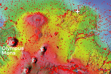
In this area of that drainage the canyons appear to follow southwest to northeast trending fault lines. Tempe Fossae is one of the smaller of these canyon complexes. All however appear to drain out into the northern plains.

Most of the MRO images of features in this area focus on the canyon cliffs. This image however focused on this one isolated small cliff in the middle of the canyon. To my eye it appears that these features document the slow drying of that vast intermittent ocean in Mars’s northern plains. The cliff is actually two steps, with the higher one appearing to mark an older shoreline. The lower cliff is abutted by a low flat area where it appears as if there had once been ponded water, now dried.

close-up of cracked area

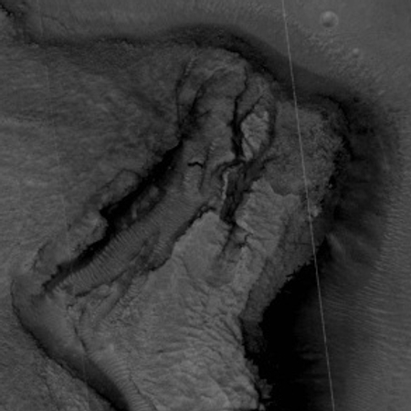
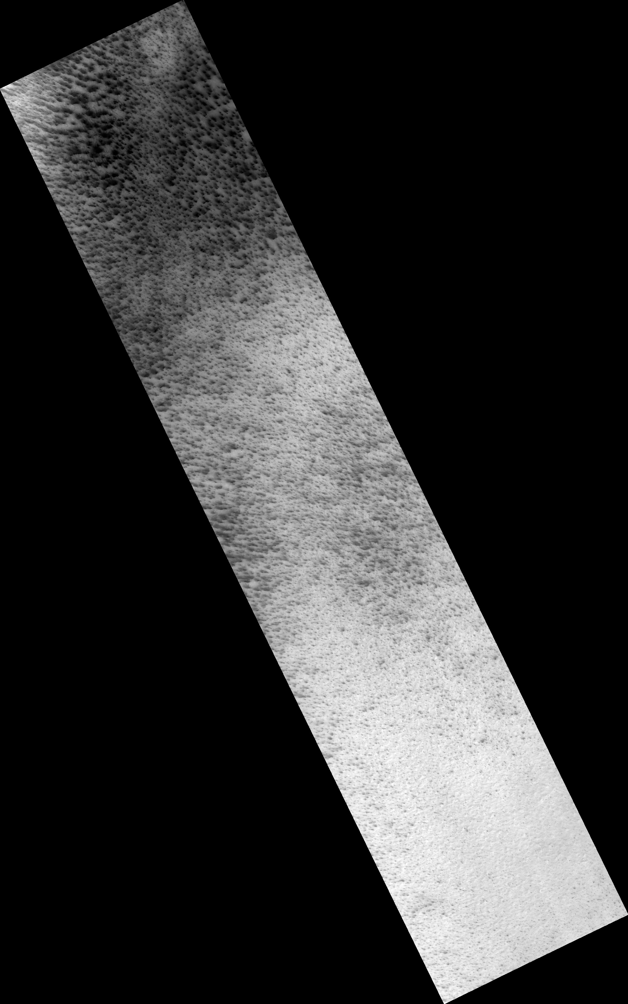
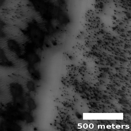
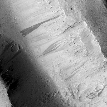
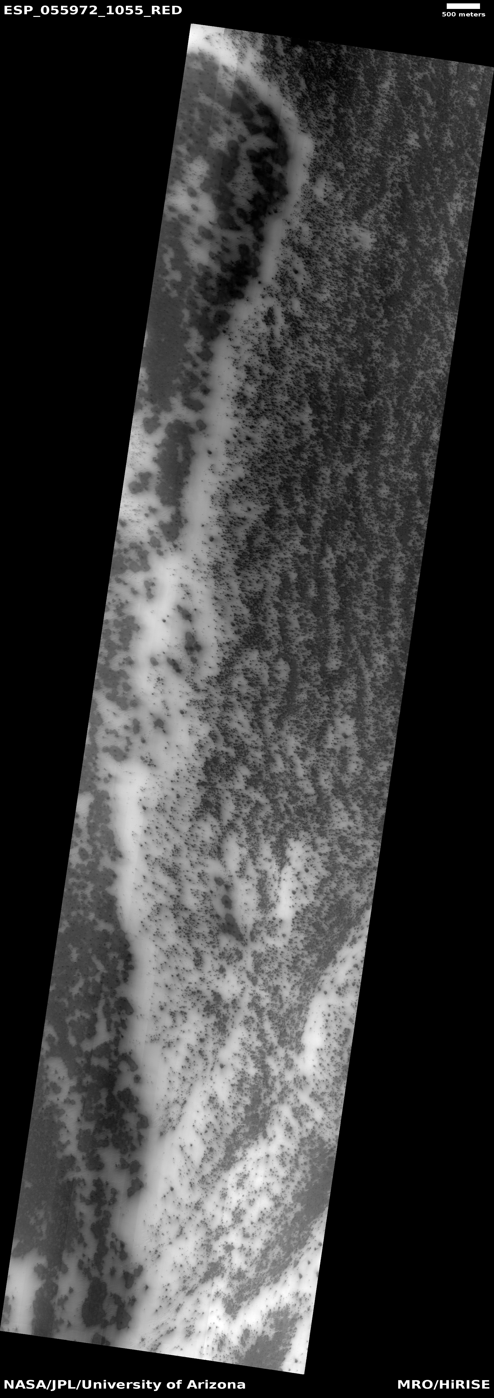
The cracks in the cliff itself suggest it is slowly breaking apart and falling down towards that low flat area. In fact, the entire feature reminds me of the sand cliffs that are sometimes found along shorelines. The sand is not very strong structurally, and with time sections will separate and then fall down. The image to the right zooms in on this cracked region. The presence of sand dunes reinforces my impression.

I imagine that as the water drained down from the glaciers on the sides of the volcanoes and filled that intermittent sea, the shoreline regions would have had the most water. At Tempe Fossae the canyons might have been partly filled. As the water level drained out and lowered, first the upper cliff edge was exposed, then the lower. The draining water probably helped created these cracks as it flowed down through them.

Finally, the last remaining pits of water ponded at the base of the cliff, eventually drying out. With time, the weakly structured sand cliffs, already carved partly by the flowing water, began to slump apart and fall downward, producing the cracks we now see. I expect that some time in the near future, on geological time scales, there will be a landslide and the outer section will collapse downward.

1 comment

Baby volcanoes on Mars

Pitted cones on Mars

Most people are very aware of Mars’ giant volcanoes. This week the science team for Mars Reconnaissance Orbiter (MRO) decided to highlight instead a location on Mars filled with relatively tiny volcanoes. The image on the right is only one small section from the full image, and shows some of these pitted cones, as well the strange nearby badlands. From their caption:

The origins of these pitted mounds or cratered cones are uncertain. They could be the result of the interaction of lava and water, or perhaps formed from the eruption of hot mud originating from beneath the surface.

These features are very interesting to scientists who study Mars, especially to those involved in the ExoMars Trace Gas Orbiter mission. If these mounds are indeed mudโ€“related, they may be one of the long sought after sources for transient methane on Mars.

The age of these pitted cones is not known. They might be still active, or have sat on Mars unchanged for eons.

Overview map

As always, context is crucial for gaining a better understanding of what we are looking at. The map on the right shows that these particular cones, indicated by the white cross, are located in an area of those plains dubbed Chryse Planitia, part of the vast northern plains of Mars, an area where some scientists think an intermittent ocean might have once existed. As you can see, this is also the region that took most of the apparent drainage running off the slopes of the planet’s giant volcanoes.

Nor are these cones unique in this region. MRO has taken a good scattering of images at this general location (41 degrees north, 332 degrees east), and throughout the surrounding terrain are many more of these pitted cones.

If these cones are a source of the transient methane on Mars, then the Trace Gas Orbiter should eventually see a concentration of methane above them. This would not prove them to be the source, but it would make them a much more intriguing target for a later rover mission.

0 comments

The search for Mars Polar Lander

A small section where Polar Lander might have crashed

In December 1999 the U.S. lander Mars Polar Lander was to set down near the southern polar cap of Mars. After an almost routine eleven month journey to Mars, all efforts to contact the spacecraft after its landing failed. A NASA review eventually concluded that the spacecraft had prematurely shut down its landing engines while the spacecraft was still far above the surface, and had therefore crashed to the ground.

Since then there have been extensive efforts to locate the lander’s remains on the surface, all to no avail. Though Mars Global Surveyor, in orbit at the time, tried to find it, its resolution was not sufficient. In recent years Mars Reconnaissance Orbiter (MRO) has taken several dozen high resolution images of the estimated landing area, two of the most recent were included in the August 2018 image release. The image on the right is a cropped section of one of those images, illustrating the difficulty of the search. (If you click on the image you can explore the full version.) The other image is quite similar.

As the southern polar cap shrinks and grows seasonally, it produces endless numbers of black spots from the release of underground dust as the carbon dioxide dry ice sublimates into gas. Moreover, the growth and retreat of the dry ice cap changes the landscape, periodically covering any remains of the rover as well as quickly removing many of the ground disturbances that the crash might have caused. In the almost two decades since the lander’s crash landing, about ten Martian years have passed, meaning that cap has melted and frozen ten times over this region in that time.

Images taken by MRO of Mars Polar Lander landing area

The image on the right shows the footprint of all the images that MRO has so far taken of the Mars Polar Lander landing area. If you are ambitious and want to get your name in the news, all you have to do is spend some time combing through those images and find the lander there. Every one of these images is available for public download at full resolution. Go to HiRise image archive, hover your mouse over latitude 77 degrees south, longitude 166 degrees east, and click several times to zoom in. You then change the selector icon at the top from “+” to “the arrow”. When next you click on any portion of that footprint it will show you a bunch of the images taken, all of which you can now download and inspect.

If you are successful and find the lander, please let me know. It would be nice to make that announcement here on Behind the Black.

0 comments

Inexplicable high latitude Martian terrain

Inexplicable high southern latitude Martian terrain

Strange image time! The image on the right, reduced in resolution to post here, comes from the August 1, 2018 image release from the high resolution camera on Mars Reconnaissance Orbiter (MRO). (If you click on the image you can see the full resolution version.) I have not cropped this image at all, so that you can see all of its swirling terrain.

This image did not come with a caption. The image site merely describes this terrain as having an “interesting morphology.” The location, in the very high southern latitudes (78 degrees south) just outside the southern rim of a very large crater, provides a slight explanation, as the growth and retreat of the Martian carbon dioxide polar caps is known to create very strange landforms. These swirling flows are obviously an example of one such landform.

The crater rim is just off of the top of the image and parallel with it. Therefore, the apparent erosional flows going around the hills and mesas are running parallel to the rim, not down from it. The black specks scattered about are probably points where dust was released as the carbon dioxide turned from ice to gas, a process that at the high latitudes on Mars often causes what planetary scientists call “spiders.”

I will not even try to make a guess at the process that formed what we see here. The image itself was taken on June 16, 2018 as part of a seasonal monitoring effort, which means scientists expect there to be changes occurring here from year to year as the polar cap shrinks and grown. An almost identical image had been taken two years ago, on December 18, 2016, and shows almost no black specks, probably because of the different time in the Martian year. A much closer comparison of both high resolution images would be necessary to tease out any more subtle changes.

4 comments

A strange bulge on Mars

Pollack Crater

Cool image time! The image on the right is not the cool image, but a context image of 59-mile-wide Pollack Crater, located slightly south of the Martian equator in the planet’s southern cratered highlands. What makes this crater intriguing to planetary scientists, and has prompted them to take many images over the decades, is the bulge in the southwest part of the crater’s floor. You don’t normally see a rise off-center like this inside craters. If there were any peaks, you’d expect them to be in the center, formed during the impact, when the crater floor melts and acts more like water in a pond when you drop a pebble into it, forming ripples with an uplifting drop in the dead center.

It therefore isn’t surprising that planetary scientists have taken a lot of pictures of this bulge, going back to the Mariner 9 orbiter in 1972, which first discovered it. Scientists then dubbed it “White Rock” because in the first black & white images it looked much brighter than the surrounding terrain. Later color images revealed that it is actually somewhat reddish in color, not white. As noted at this Mars Global Surveyor webpage,
» Read more

0 comments

Cryptic terrain in Martian high southern latitudes

Cryptic terrain in Reynolds Crater near Mars south pole

Cool image time! The image on the right is a small cropped section from a larger image taken of the floor of Reynolds Crater, near the margins of the Martian southern polar carbon dioxide icecap.

The image was part of the August 1, 2018 image release from the high resolution camera on Mars Reconnaissance Orbiter (MRO) and was taken on July 5, 2018. Because that was during the peak of now clearing global dust storm, a large majority of MRO’s images were obscured. Only images taken at high latitudes appeared clear and sharp.

The image link, which has no caption, calls this “cryptic terrain.” Since this is at the margin of the polar cap, the white areas are almost certainly still-frozen dry ice. The white strip down the center of the image appears to be a low drainage gully, made even more evident on the full image.

What are the dark spots however? These are probably related to the dark spiders that appear wherever the carbon dioxide starts to melt and evaporate into gas, releasing the darker dust from below to coat the surface. The dark spots in this image are probably that same darker dust, but why it is scattered about as spots and splotches is a mystery. It does appear that the dark areas more completely cover the higher terrain, but why and if so is definitely unclear.

Back in 1999 I attended a press conference just prior to the failure of Mars Polar Lander. One of the mission’s investigators explained that, based on the orbiter images available at the time, they expected the lander to see some very weird land forms once it reached the surface, shaped in ways that are not seen on Earth. Unfortunately, contact with the spacecraft was lost just before it entered the Martian atmosphere, and was never recovered.

This image however remains me of that scientist’s lost expectation. The seasonal growth and retreat of the Martian icecaps will likely create some strange geology, which is only hinted at in this particular MRO image.

0 comments

Mars dust storm blocks Mars Reconnaissance Orbiter images

In my normal routine to check out the periodic posting of new high resolution images from Mars Reconnaissance Orbiter (MRO), the August 1 update brought what at first was a disturbing surprise. If you go to the link you will see that a large majority of the images show nothing by a series of vertical lines, as if the high resolution camera on MRO has failed.

Yet, scattered among the images were perfectly sharp images. I started to look at these images to try to figure out the differences, and quickly found that the sharp images were always of features in high latitudes, while the blurred images were closer to the equator.

The August 1 image release covered the June/July time period, when the on-going Martian dust storm was at its height. The images illustrate also where the storm was most opaque, closer to the equator.

The next few updates, which occur every three weeks or so, should show increasing clarity as the storm subsides. And the storm is subsiding, according to the latest Opportunity update. The scientists have still not re-established contact with the rover, and do not expect to for at least a month or more, but they are finding that the atmospheric opacity at Endeavour Crater seems to be dropping.

0 comments

Another skylight entrance pit found on Mars

Pit in Hephaestus Fossae

Cool image time! In my routine monthly review of the hundreds of new images released from the high resolution camera on Mars Reconnaissance Orbiter (MRO), I came across another most intriguing geological feature, the image of which is posted to the right, after cropping.

As the scale shows, the pit is about 300 feet across. Calculating the pit’s depth would require someone with better math skills than I. The website provides information about the sun angle, which can be used to extrapolate the shadows and then roughly calculate the depth.

The most fascinating aspect of this pit is the impression of incredible thinness for the pit’s overhung edges. All of the pit’s edges appear significantly overhung, and the thickness of the overhang seems incredibly paper-thin. This thinness is likely only an illusion, though in Mars’s light gravity it is perfectly possible for the overhang to be far thinner and more extended than anything you would find on Earth.

The image itself is in color, though the only color visible is within the pit itself. In that blueness at the base it seems to me that there is a pile of dust/debris, but once again, that conclusion should not be taken very seriously.

If you take a look at the full image, what is impressive is the bland flatness of the surrounding terrain. There is no hint that there might be underground passages hidden here. While most of the scattered craters are probably impact craters, many (especially those with unsymmetrical shapes) could be collapse features indicating the presence of underground voids. None however is very deep. Nor is there any other pits visible.

Below is a global map of Mars with the location of this pit indicated by a black cross. It is just on the edge of the transition zone between the lower northern plains and the southern highlands, where the shoreline of an intermittent sea is thought by some scientists to have once existed. This is also an area where not a lot of high resolution images have been taken, mostly because of its apparent blandness as seen in previous imagery.

This image demonstrates however that Mars is going to have interesting geology everywhere, and that we won’t really know it well until we have explored it all.
» Read more

11 comments

A dark dust avalanche on Mars

No dust avalanche

After dust avalanche

Cool image time! The two images to the right, both cropped to post here, were taken six years apart by Mars Reconnaissance Orbiter (MRO) of the western lava slopes of the giant volcano Olympus Mons. They show the appearance of a dark dust avalanche during the interim. As noted by members of the MRO science team.

Dust avalanches create slope streaks that expose darker materials usually hidden below a lighter-toned layer. Cascading fine-grained material easily diverts around boulders or alters direction when encountering a change in slope. The dark steak … is approximately 1 kilometer in length that we didnโ€™t see in a previous image. Past avalanche sites are still visible and fading slowly as dust settles out of the atmosphere and is deposited on the dark streaks over time.

We also see boulders and their shadows that are a meter or greater in size. Movement of any of these boulders down the slope could trigger future avalanches.

The appearance of these Martian dark streaks on slopes is actually not uncommon. As more pictures are taken of Mars scientists are beginning to accumulate a large number all across the Martian surface.

What I find fascinating is the wet look of these dark streaks. Below is a close-up of the new avalanche, near its head.
» Read more

4 comments

Spiders on Mars!

spiders on Mars

Cool image time! Today’s release of new captioned images from the high resolution camera on Mars Reconnaissance Orbiter (MRO) included a wonderful image of the melting carbon dioxide cap of Mars’s south pole. On the right is a cropped portion of the full image, showing what the MRO scientists nickname spiders, features that appear as the CO2 begins to turn into gas.

But these arenโ€™t actual spiders. We call it โ€œaraneiform terrain,โ€ to describe the spider-like radiating channels that form when carbon dioxide ice below the surface heats up and releases. This is an active seasonal process we donโ€™t see on Earth. Like dry ice on Earth, the carbon dioxide ice on Mars sublimates as it warms (changes from solid to gas) and the gas becomes trapped below the surface.

Over time the trapped carbon dioxide gas builds in pressure and is eventually strong enough to break through the ice as a jet that erupts dust. The gas is released into the atmosphere and darker dust may be deposited around the vent or transported by winds to produce streaks. The loss of the sublimated carbon dioxide leaves behind these spider-like features etched into the surface.

The image above shows older spiders, formed during past seasonal events. If you click on the image you can see the full image, which shows darker spiders produced by this season’s cycle.

0 comments

The mysterious chaos terrain of Mars

In one of my weekly posts last month (dated May 14th) delving into the May image release from Mars Reconnaissance Orbiter’s (MRO) high resolution camera, I featured an image of what planetary geologists have labeled chaos terrain, a hummocky chaotic terrain that has no real parallel on Earth but is found in many places on Mars.

This month’s image MRO release included two more fascinating images of this type of terrain. In addition, the Mars Odyssey team today also released its own image of chaos terrain, showing a small part of a region dubbed Margaritifer Chaos. Below, the Mars Odyssey image is on the right, with one of the MRO images to the left. Both have been cropped, with the MRO image also reduced in resolution. The full MRO image shows what the MRO science team labels “possibly early stage chaos” on the rim of a canyon dubbed Shalbatana Vallis.

young chaos in Shalbatana Vallis

Margaritifer Chaos

» Read more

5 comments
1 83 84 85 86 87 90