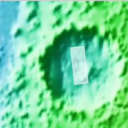
Strange crescent-shaped pit near Martian south pole

crescent-shaped pit near Martian south pole

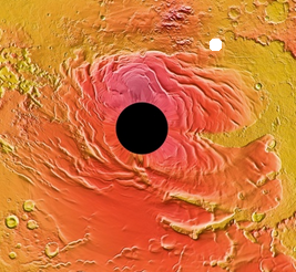
Cool image time! The south polar cap of Mars is a strange place. It is largely ice, with a seasonal cap of frozen carbon dioxide, or dry ice. Because the dry ice sublimates away during the summer months, the cap undergoes regular changes that reshape it, producing alien features that are not seen on Earth.

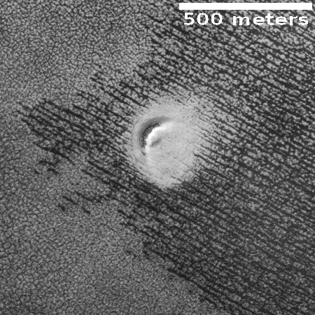
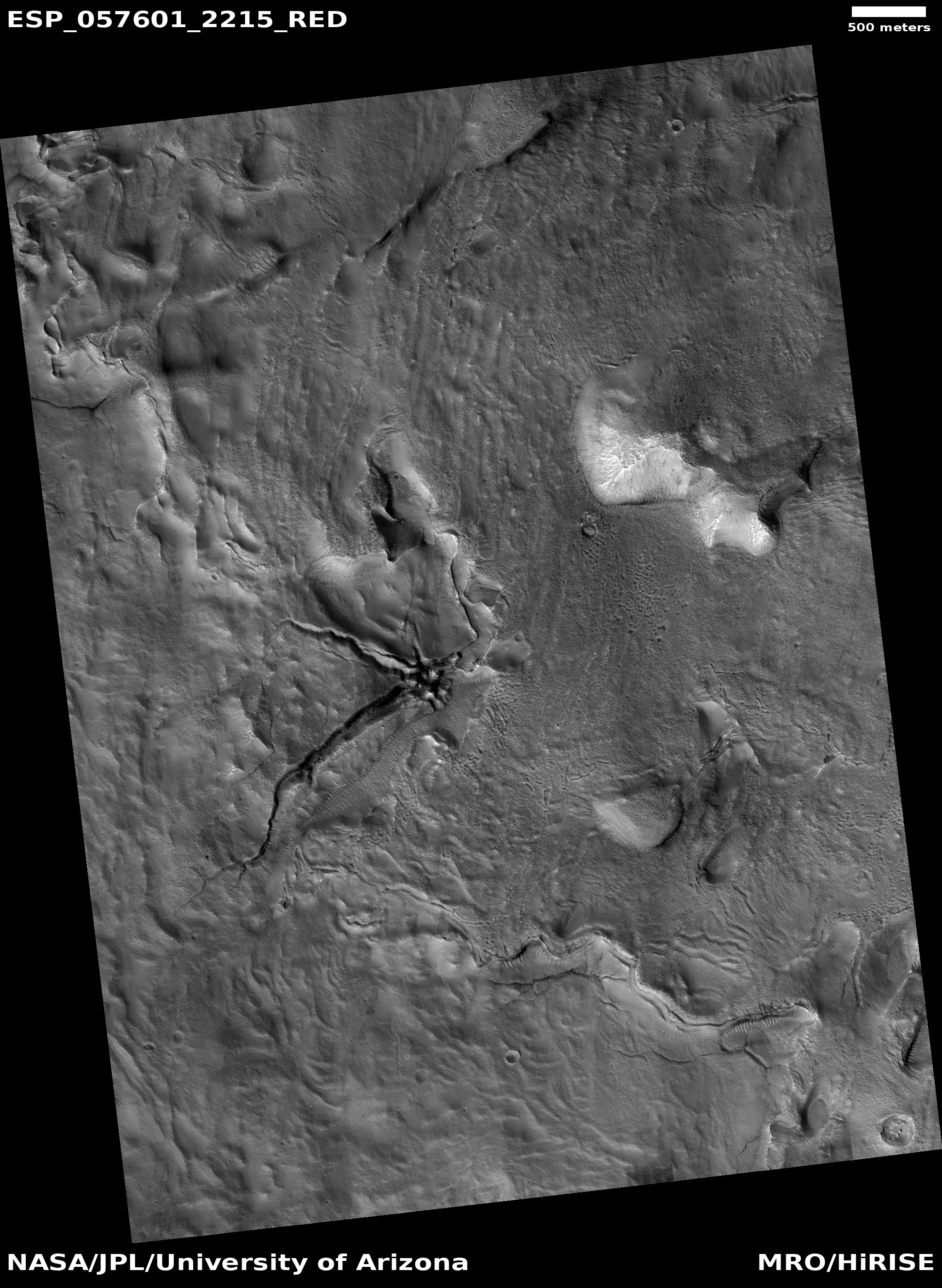
The image on the right is another example of these alien features. I found it in the February image release from the high resolution camera on Mars Reconnaissance Orbiter. I have merely cropped the full image to focus at full resolution on its primary feature, a region of stippled-like surface surrounding an area of black striping that in turn surrounds a crescent-shaped pit outlined by whiter material.

Why is there a pit here? Why is it crescent-shaped? Why is it surrounded by that whiter material? I could guess and say that the pit is a vent from which water vapor from the lower cap of water sprays out onto the upper cap of frozen carbon dioxide, staining it with white ice, but I am most likely wrong.

Moreover, what causes the black striping, as well as the stippled material surrounding it? The black stripes are probably related to a similar process that forms the spider formations found in the polar regions, except that these are not spiders. Why the parallel straight lines?

A lot of questions with no answers. While many features on Mars are strange, the features near the poles are probably stranger still, as they form in a place with chemistry, temperatures, gravity, and materials in a combination and scale that we on Earth have no experience with.

3 comments

Mysterious dark-toned Martian terrain

Dark toned ridge in Martian southern highlands
Click for full resolution image

Cool image time! The picture on the right, cropped and reduced to post here, was part of the January image release from the high resolution camera of Mars Reconnaissance Orbiter (MRO). It shows an area in the Martian southern highlands where the surface suddenly gets darker, for no obvious reason.

The uncaptioned release image is titled “Dark-Toned Ridge at Junction with Dark-Toned Plain.” From the image itself it is hard to understand this title. In the full image the darkest terrain is a strip in the center, with slightly lighter dark terrain on either side, and the lightest terrain to the north or south. The photograph however does not show us how far this dark terrain extends to the west or east.

Two Mars Odyssey image strips of less resolution, here and here, show that this region is filled with several large patches of dark-tone surface. With this particular patch the center dark ridge is surrounded by that slightly lighter dark area.

MRO itself has not taken many images of this region, as shown in the overview image below. The red rectangles indicate MRO’s high resolution photographs, with this image indicated by the cross. At this low resolution this region seems somewhat nondescript. The Mars Odyssey image strips show that there many features here, but with little significant relief.

Location of dark toned ridge

At high resolution there does not appear to be much difference between the darker and lighter areas. The lighter areas in general seem less rough and at a slightly lower elevation, but both areas are dominated by ridges and dunes trending southwest-to-northeast.

Why is this slightly higher region darker? Let’s assume that this darker material was a lava flow overlaying the surface. Over eons wind erosion, trending southwest-to-northwest, roughly eroded both it and the lower layers around it, leaving behind this rough corroded terrain. The different make-up of the darker material allows it to erode in a rougher manner.

While possibly correct, I would not bet much money on this guess. It is not clear it is lava. It is not clear that it is a flow. It does not explain why there are two areas of different darkness. And it certainly not clear what the make-up of any of this stuff is.

This is simply another cool mystery on the Martian surface.

1 comment

Strange fernlike ridges on Mars

Fernlike ridges on Mars

Cool image time! The two images on the right, cropped, rotated, and reduced in resolution to post here, were both taken by the high resolution camera on Mars Reconnaissance Orbiter (MRO). To see the full resolution version of each, go to the 2009 and 2018 releases.

The 2009 release was a captioned release, whereby scientist Alfred McEwen of the science team provided his explanation of these strange features.

The dark branched features in the floor of Antoniadi Crater look like giant ferns, or fern casts. However, these ferns would be several miles in size and are composed of rough rocky materials.

A more likely hypothesis is that this represents a channel network that now stands in inverted relief. The channels may have been lined or filled by indurated materials, making the channel fill more resistant to erosion by the wind than surrounding materials. After probably billions of years of wind erosion the resistant channels are now relatively high-standing. The material between the branched ridges has a fracture pattern and color similar to deposits elsewhere on Mars that are known to be rich in hydrated minerals such as clays.

These strange fernlike features do not appear to be very common on Mars. In fact, I suspect that while Mars does have many inverted channels like this, the fernlike nature of these particular channels is unique on Mars. They are located on the floor of Antoniadi Crater, a large 240-mile-wide very ancient and eroded crater located in the Martian southern highlands but near the edge down to the northern lowlands.

In seeing the new 2018 image, I was immediately compelled to place it side by side with 2009 image to see if anything had changed in the ensuring near-decade. There are color differences, but I suspect these are mostly caused by different lighting conditions or post-processing differences. Still, the dark center to the crater in the upper left of both images suggests a change in the dust dunes there, with the possibility that some of the dust has been blown from the crater over time. Also, you can see two horizontal tracks cutting across the center of the 2018 image, which I would guess are dust devil tracks, with one more pronounced.

I can imagine some planetary geologists have spent the last few months, since the second image was taken, pouring over both photographs, and have might even located other interesting changes. And if they find no significant changes, that in itself is revealing, as it gives us a sense of the pace at which the Martian surfaces evolves.

3 comments

The many pits/caves of Mars

Sinkhole in Martian northern lowlands with dark seep

Time for many cool images! Over the years I have written frequently about the pits/caves on Mars, in both magazine articles and the many posts here at Behind the Black. The following posts are the most significant, with the June 9, 2015 providing the best geological background to many of these pits, especially the many located near the giant volcanoes of Mars.

As I wrote in that June 9, 2015 post:
» Read more

1 comment

Weird Martian fracture feature

Fractured collapse feature on Mars

Cool image time! When I first looked at the high resolution Mars Reconnaissance Orbiter (MRO) image on the right, my immediate reaction was, “What the heck is that?” The image to the right is cropped and reduced, but if you click on it you can see the full image at high resolution.

The fractured terrain appears to be all within a collapse. To my eye it appears that while the overall surface has sunk, the fractures indicate an area where there has been an eruption upward, which after the eruption collapsed again, so that the fractured area remains at the apparent bottom of the collapse sink. I was immediately reminded of Upheaval Dome in Yellowstone National Park, which some geologists believe was formed by a “salt bubble” rising upward to create a salt dome.

A thick layer of salt, formed by the evaporation of ancient landlocked seas, underlies much of southeastern Utah and Canyonlands National Park. When under pressure from thousands of feet of overlying rock, the salt can flow plastically, like ice moving at the bottom of a glacier. In addition, salt is less dense than sandstone. As a result, over millions of years salt can flow up through rock layers as a “salt bubble”, rising to the surface and creating salt domes that deform the surrounding rock.

Context image for fracture feature

The process and materials involved were certainly different on Mars. Nonetheless, it does appear we are looking at an eruptive feature unrelated to molten lava. The context image to the right, showing this feature’s location in Mars’ vast northern lowlands, also shows that it has occurred on terrain that has bulged upwards relative to the surrounding lowlands. Nearby MRO images also show similar bulge/collapse features.

To decipher the geological mystery here, we would also need to know when this happened and whether there ever was a liquid ocean residing on top of it, before, during, or after the eruption. We also do not know well the make-up of the underground materials, including whether any frozen water and salt is present.

To be honest, we really don’t know much. I am sure a planetary scientist studying this feature could fill us in on some of these details, such as information provided by the colors in the color image. Even so, I am sure any good scientist would also admit to unknowns.

To get some real answers, we need to be there. It is as simple as that.

0 comments

Martian glacier with moraine?

Glacier flow on Mars, with moraine

Cool image time! In the past two decades numerous images and studies of the Martian terrain produced by orbiters have shown us landslides, lava flows, water and ice produced flows, and many glacial features, all vaguely familiar but often having components reminding us of the alien nature of the Martian landscape. I have posted many here at Behind the Black. (Just do a search here for the words “Mars flow” and you will have a wealth of cool images and alien geological features to explore.)

The image on the right, rotated, cropped, and reduced to post here, shows another such feature, but this time it is less alien and more resembling a typical Earth glacier, flowing downhill slowly and pushing a moraine of debris before it. The picture was taken by the high resolution camera on Mars Reconnaissance Orbiter (MRO) and was part of the January image release. If you click on the image you can see the complete photograph at full resolution.

The release has no caption, but is titled “Tongue-Shaped Glacier in Centauri Montes,” referring to the largest tongue-shaped flow on the left. This feature, more than any other in the image, resembles closely many glaciers on Earth. It even has an obvious moraine at its head. As the glacial flow pushed downward slowly it gathered a pile of material that eventually began to act almost like a dam.

The location of this feature is intriguing in its own right.
» Read more

0 comments

New impact on the Martian south polar cap

New impact on Mars' south pole

Cool image time! The image to the right, cropped to post here, was taken on October 5, 2018 by the high resolution camera on Mars Reconnaissance Orbiter (MRO) and shows a recent meteorite impact that occurred sometime between July and September of 2018 on the Martian polar cap . If you click on the image you can see the entire photograph. As noted in the captioned press release,

Itโ€™s notable because it occurred in the seasonal southern ice cap, and has apparently punched through it, creating a two-toned blast pattern.

The impact hit on the ice layer, and the tones of the blast pattern tell us the sequence. When an impactor hits the ground, there is a tremendous amount of force like an explosion. The larger, lighter-colored blast pattern could be the result of scouring by winds from the impact shockwave. The darker-colored inner blast pattern is because the impactor penetrated the thin ice layer, excavated the dark sand underneath, and threw it out in all directions on top of the layer.

Location on edge of south polar cap

It is not known yet the size of this meteorite. The location is shown in the overview image to the right, with the impact indicated by the white dot. The black circle in the middle of the image is the south pole itself, an area where MRO’s orbit does not allow imagery. This location, on the edge of the Martian polar cap, is helpful to scientists because it has excavated material from below the cap, providing them a peek into previously unseen the geology there. Had the impact been farther south, on the thicker cap, that hidden material below the cap would likely not have been exposed.

The cap itself is made up of both ice and frozen carbon dioxide, though the CO2 is mostly seen as frost during winter months that evaporates during the summer.

2 comments

Volcanic vent between Arsia and Pavonis Monsa

volcanic vent on Mars

Cool image time. The photo on the right, rotated, cropped, and reduced to post here, was taken in September by the high resolution camera of Mars Reconnaissance Orbiter (MRO) and was part of the November image release. Click on the image to see the entire photograph at full resolution.

The uncaptioned release dubs this feature as “Small Eruptive Vents South of Pavonis Mons.” In truth, these vent pits are located almost exactly the same distance from both Pavonis Mons, the middle volcano in the line of three giant Martian volcanoes, and Arsia Mons, the southernmost of the three.

The image is interesting for several reasons. First, note the bulge surrounding the vent, making this look almost like a miniature volcano all its own. In fact, that is probably what it is. When it was active that bulge was likely caused by that activity, though it is hard to say whether the bulge was caused by flow coming from out of the vent, or by pressure from below pushing upward to cause the ground to rise. It could even have been a combination of both.

To my eye, most of the bulge was probably caused from pressure from below pushing upward. The edge of the bulge does not look like the leading edge of a lava flow. Still, this probably happened so long ago that Martian wind erosion and dust could have obscured that leading edge.

That this is old is indicated by the dunelike ripples inside the large pit, and the pond of trapped dust in the smaller pit. Because of the thinness of the Martian atmosphere it takes time to gather that much dust, during which time no eruptions have occurred.

One more interesting detail: If you look at the pits in full resolution, you will see that, based on the asymmetrical wind patterns between the west and east rims, the prevailing winds here are from the west. Located as it is just to the east of the gigantic saddle between Arsia and Pavonis Mons, this wind orientation makes sense, as a saddle between mountains tends to concentrate the wind, much like a narrowed section in a river produces faster water flow and rapids. As for why the wind blows mostly from the west, my guess (which should not be taken very seriously) is that it is probably caused by the same meteorological phenomenon that causes this generally on Earth, the planet’s rotation.

0 comments

Weird erosion in large Martian craters

Central pit in Asimov Crater

Cool image time! In reviewing the images in the December image release from the high resolution camera on Mars Reconnaissance Orbiter (MRO, I came across the image to the right, cropped, rotated and reduced to post here, showing the western half of the central pit of Asimov Crater. (Click on the link for the entire photograph.) The eastern half can be seen here.

It is unusual to see central pits in craters. One instead expects to see central peaks. The pit itself is intriguing because of its sinkhole appearance. In both the northwest and southwest corners you can clearly see drainages flowing down into the pit, including recent faint darkened streaks indicative of past seep avalanches. The same can been seen for the pit’s eastern half. Along the pit’s western rim are parallel cracks suggesting that the plateau itself is slowly shifting downward into the pit.

Furthermore, the rim cliff has multiple drainage gullies, all beginning just below the initial top layers. The look of those cliffs is very similar to what sees on the walls of the Grand Canyon, where the top of the cliffs show layers with the bottom of the cliffs buried under a slope of alluvial fill, material that has fallen to slowly form those slopes. The drainage gullies however would have come later, and suggest that some form of seepage is coming out of the contact between the layers at the top of the slope.

A look at the context image below and to the right reveals the greater mystery of this crater, as well as nearby Maunder Crater, the subject of a recent captioned image release from Mars Odyssey.

context map showing Asimov and Maunder Craters

In both cases a circular interior gully separates the crater floor from the crater’s rim. In fact, the crater floor almost appears raised. This is especially striking with Asimov Crater, where the central floor appears like a very flat plateau, except for that central pit and the surrounding gully.

The MRO team has taken a lot of images of the gullies, which you can see if you zoom in to latitude -46.843ยฐ longitude 4.831ยฐ on the map image at this website. It is clear that they want to know more about the origins of this geology. It suggests water flow, even though these craters are located in the Martian southern highlands, a place that is more reminiscent of the Moon, with many ancient craters and far less evidence of significant change.

What the geology in these two craters suggest is that some erosion process is eating away at the crater floors, beginning at its edges as well where there are voids below that allow the surface to sink. While that erosion is certainly helped by wind, it also implies the presence of underground water, either as ice or liquid, in the past and even possibly today.

0 comments

Lopsided ejecta from Martian crater

Crater with unequal ejecta

Cool image time! The image on the right, reduced and cropped to post here, comes from the December image release from the high resolution camera of Mars Reconnaissance Orbiter (MRO). (If you click on the image you can see the full resolution uncropped photograph.) Released without a caption, the release itself is intriguingly entitled, “Crater with Preferential Ejecta Distribution on Possible Glacial Unit.

The uneven distribution of ejecta material around the crater is obvious. For some reason, the ground was preferentially disturbed to the north by the impact. Moreover, the entire crater and its surrounding terrain look like the impact occurred in a place that was saturated somewhat with liquid, making the ground soft like mud.

That there might have been liquid or damp material here when this impact occurred is reinforced by the fact that this crater is located in the middle of Amazonis Planitia, one of the larger regions of Mars’ vast northern lowland plains, where there is evidence of the past existence of an intermittent ocean.

This however really does not answer the question of why most of the impact’s ejecta fell to the north of the crater. From the release title is appears the planetary geologists think that this uneven distribution occurred because the impact occurred on a glacier. As the ground has a lighter appearance just to the south of the crater, I suspect their reasoning is that this light ground was hard bedrock while the darker material to the north was that glacial unit where the ground was more easily disturbed.

This is a guess however (a common requirement by anyone trying to explain the strange features so often found on the Martian surface). Other theories are welcome of course, and could easily be correct as well.

5 comments

Flowing cracked mud on Mars?

mud cracks in crater?

Cool image time! The image on the right, rotated, cropped, and reduced to post here, comes from the December image release of the high resolution camera of Mars Reconnaissance Orbiter (MRO. Uncaptioned, the release titles this image “Cracks in Crater Deposit in Acheron Fossae.” If you click on the image you can see the entire photograph at full resolution.

Clearly the cracks appear to be caused by a downward slumping to the north, almost like a glacier made of mud. We can also see places on the image’s right edge where the mud appears to have flowed off a north-south trending ridge, then flowed downhill to the north. All of this flow is away from the crater’s central peak, which is only partly seen in the photograph near the bottom. That section is the central peak’s southwestern end, with the whole peak a ridge curving to the northeast beyond the edge of the image.

At the north edge of this mud flow the cracks become wider canyons, as if long term erosion is slowing washing the mud away. The flow then stair steps downward in a series of parallel benches. Meanwhile, in the flat central area of the mud flow above can be seen oblong depressions suggesting sinks that also flow to the north.

crater context overview

You can get a better idea of the crater’s overall floor and central peak by the low resolution context image to the right. The white rectangular box indicates the area covered by the full image above. A close look at this part of the crater floor suggests to me a circular feature like a faint eroded smaller crater that includes as its eastern rim the larger crater’s central peak. This impression suggests that the flows seen in the full resolution image are heading downhill into the lowest point of this smaller crater, that upon impact had reshaped the larger crater’s floor.

This impression however is far from conclusive. The features in the large crater could simply be the random geology that often occurs in the floors of impact craters.

What makes this particular mud slide most interesting, as is usually the case for most Martian terrain, is its location.
» Read more

0 comments

Dust devil tracks on the Martian southern highlands

Dust devil tracks

Today’s cool image is cool because of how little is there. The image to the right, cropped to post here, was part of the December image release from the high resolution camera on Mars Reconnaissance Orbiter (MRO). The uncaptioned release labeled this image simply as “Southern Intercrater Plains.” Located in the Martian southern highlands, this location is located almost due south of Arsia Mons, the southernmost in the chain of three giant volcanoes to the west of Marineris Valles (as indicated by the white dot on the overview image below).

If you click on the image you can see the entire photograph, though in this case it won’t show you much else than in the excerpt to the right. The terrain here appears flat. The only features of note are some small knobs and the random dark lines that are almost certainly accumulated dust devil tracks. There are also many dark spots, which might also be the shadows of even smaller knobs, but could also be instrument artifacts. I am not sure.

Location of dust devil image

The southern highlands are mostly cratered, with few signs that water ever flowed there. This image for example gives the impression of a vast lonely terrain that has changed little since the very earliest days of Mars’ history.

I expect that scientists could possibly assign some age to this terrain, merely by studying the dust devil tracks. If we calculate how often dust devils might traverse this place, and then count the tracks, assigning their order by faintness, with the faintest being the oldest, it could be possible to obtain a rough age of the oldest tracks.

Still, all that would do would tell us the approximate length of time in which a dust devil track can remain visible. And even if this is a long time, it doesn’t constrain the age of the surface very much, as the weather on Mars has certainly changed with time, especially because we think the atmosphere was once thicker.

What formed this flat terrain? My first guess would be a lava flow, caused when the numerous nearby craters were formed by impact. These craters were likely created during the great bombardment between 3 and 4 billion years ago, and while they have certainly been modified more than lunar craters because of the presence of an atmosphere on Mars, they are likely to have not changed much during that time. Similarly, this flat terrain is likely much like it was, several billion years ago. Dust devils have deposited dust and their tracks, but the hard bedrock remains as it was soon after it solidified.

6 comments
1 81 82 83 84 85 90