Another intriguing pit on Mars

pit on Mars

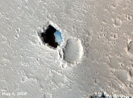
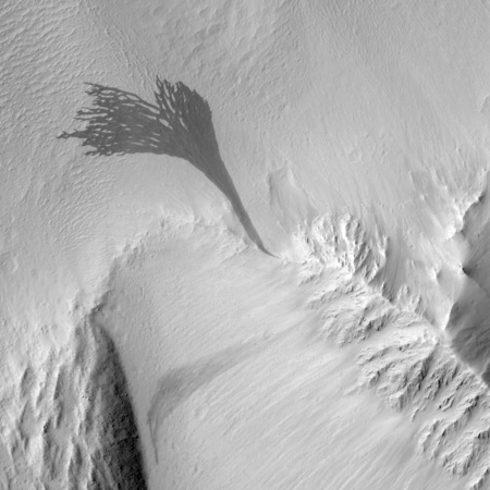
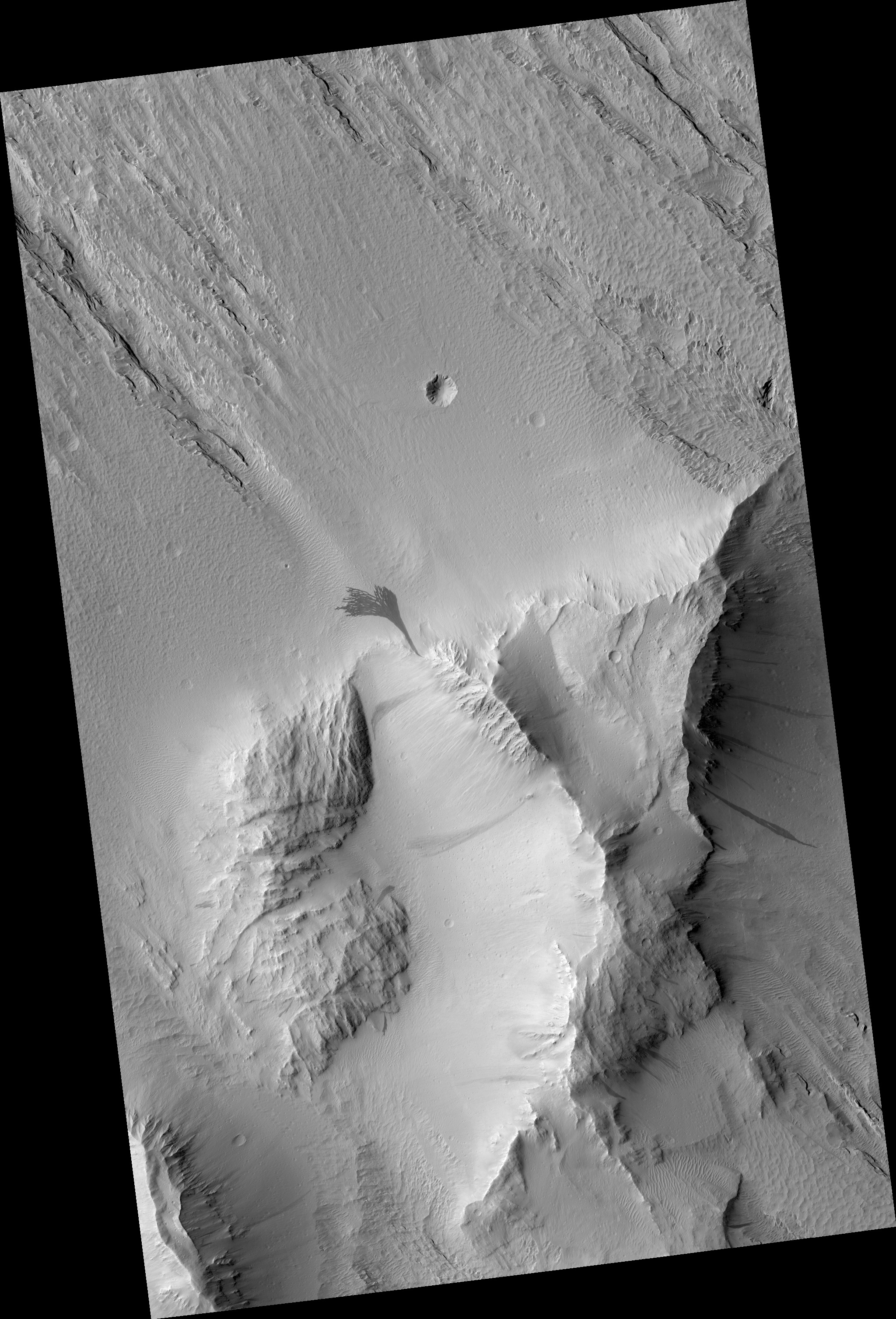
Cool image time! In the June release of images from the high resolution camera on Mars Reconnaissance Orbiter, I came across the image on the right, cropped slightly to post here, of a pit in a region dubbed Hephaestus Fossae that is located just at the margin of Mars’s vast northern plains.

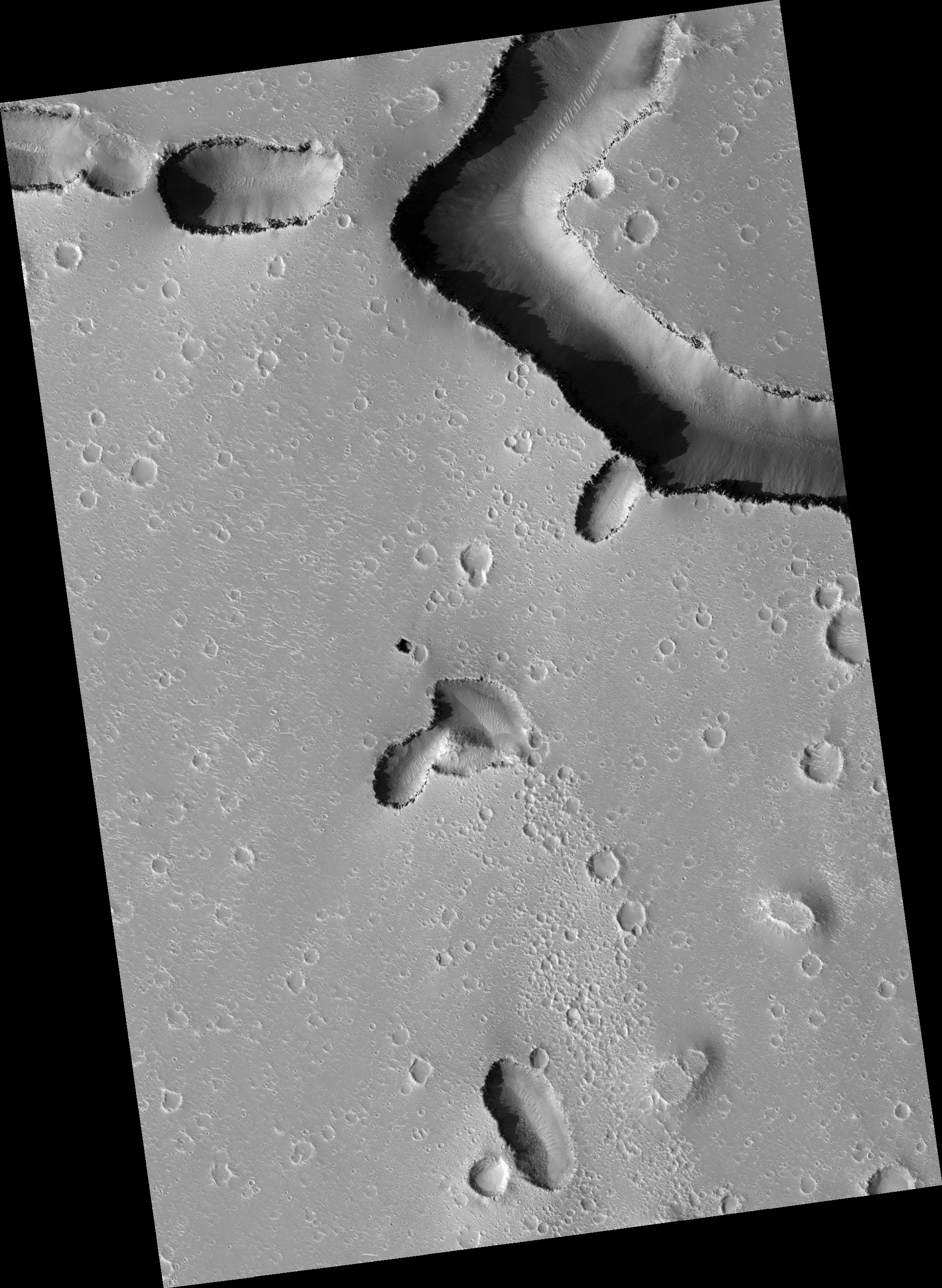
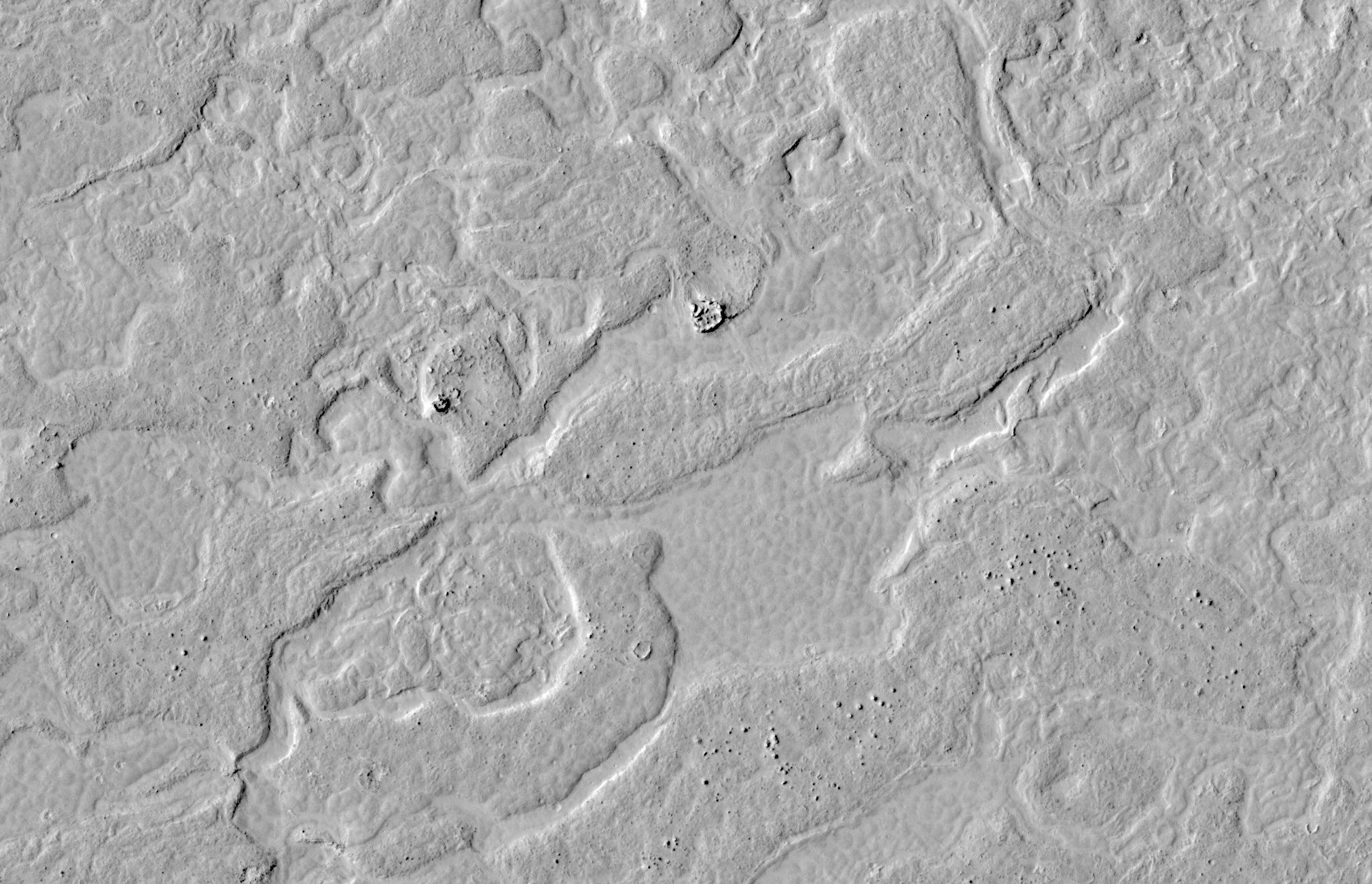
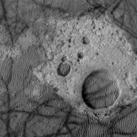
Below and to the right is an annotated second image showing the area around this pit. If you click on it you can see the full resolution image, uncropped, and unannotated.

wider view of pit

The scale bar is based on the 25 centimeter per pixel scale provided at the image link. Based on this, this pit is only about ten to fifteen meters across, or 30 to 50 feet wide. The image webpage says the sun was 39 degrees above the horizon, with what they call a sun angle of 51 degrees. Based on these angles, the shadow on the floor of the pit suggests it is about the same depth, 30 to 50 feet.

The shadows suggest overhung walls. This, plus the presence of nearby aligned sinks, strongly suggests that there are extensive underground passages leading away from this pit.

For a caver on Earth to drop into a pit 30 to 50 feet deep is nowadays a trivial thing. You rig a rope (properly), put on your vertical system, and rappel in. When you want to leave you use that same vertical system to climb the rope, using mechanical cams that slide up the rope but will not slide down.

On Mars such a climb would be both easier and harder. The gravity is only one third that of Earth, but the lack of atmosphere means you must wear some form of spacesuit. Moreover, this system is not great for getting large amounts of gear up and down. Usually, people only bring what they can carry in a pack. To use this Martian pit as a habitat will require easier access, preferable by a wheeled vehicle that can drive in.

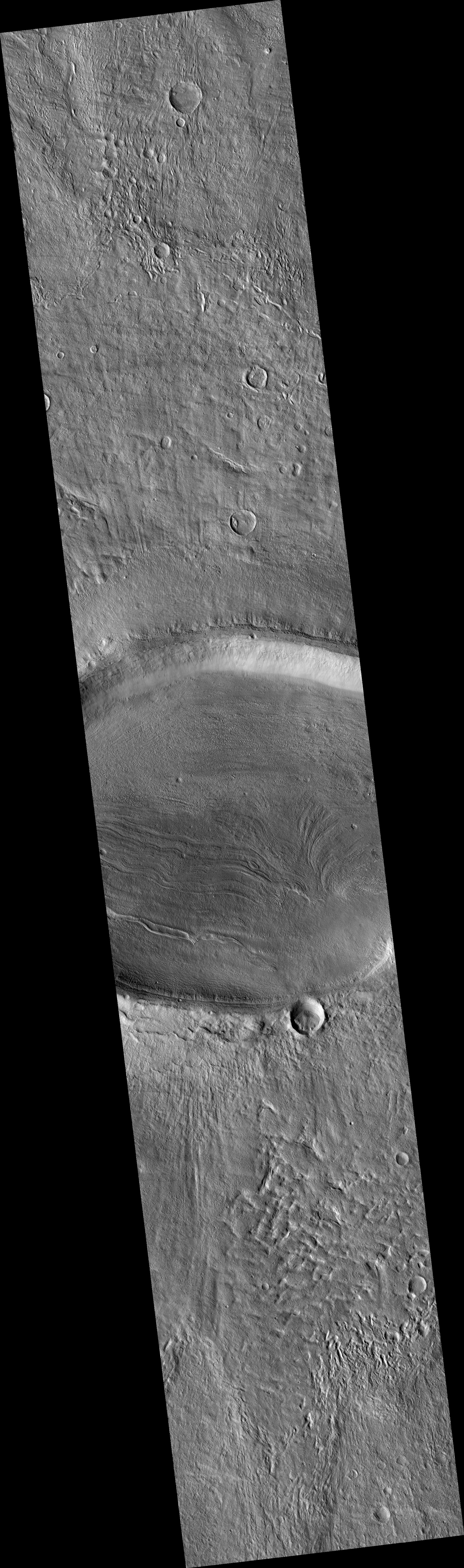
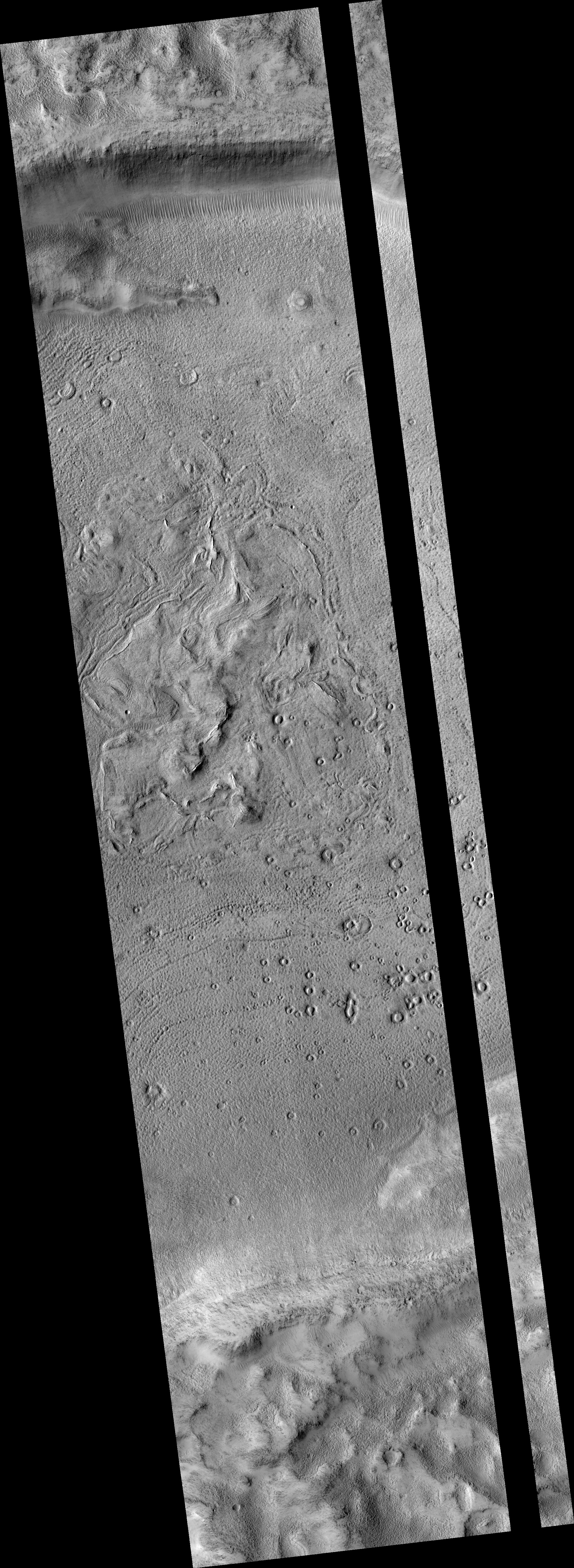
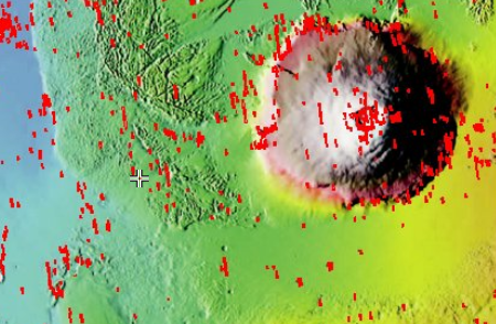
The pit’s location however is intriguing. The map below shows its location on a global map of Mars. This region is part of the Utopia Basin, the place with the second lowest elevation on Mars.
» Read more

7 comments

New impact craters on Mars

New impact crater on Mars

Cool image time! The high resolution camera on Mars Reconnaissance Orbiter (MRO) keeps finding recent impact craters, all of which the science team try to monitor periodically to see how the surface evolves over time. The image on the right, cropped to post here, is one such crater, the image taken in January 2018 and released with as one of the captioned images from this month’s image catalog release. If you click on the image you can see the full picture.

What is notable about this particular impact are the colors.

The new crater and its ejecta have distinctive color patterns. Once the colors have faded in a few decades, this new crater will still be distinctive compared to the secondaries by having a deeper cavity compared to its diameter.

Those colors of course have importance to researchers, as they reveal the different materials found beneath the surface at this location, normally hidden by surface dust and debris.

Nor is this the only impact crater revealed in this month’s image release. Earlier in the month the science team highlighted an image that captured two small impacts. While all three of these impacts are in the general region called Elysium Planitia, they are not particularly close to each other. They are however surrounding the landing site for the InSight lander now heading to Mars. This last link takes you to my January 28, 2018 post detailing some information about this landing site, and also includes another recent crater impact, found at the center of the landing zone.

It is not clear if these recent impacts are related to each other. As noted by Alfred McEwen of the science team, “Often, a bolide breaks apart in the atmosphere and makes a tight cluster of new craters.” It could be that all these recent impacts came from the same bolide, which is why there appear to be a surplus of them in Elysium Planitia.

Then again, our surface survey of Mars is very incomplete. These impacts could simply be marking the normal impact rate for Mars. We will not know until we have completed a detail survey of all recent impacts on Mars, and have been able to date them all.

Who wants to do it?

2 comments

Chaos on Mars

chaos terrain

Cool image time! The image on the right, cropped and reduced in resolution to post here, shows an area on Mars that geologists have dubbed “Chaos Terrain.” If you click on the image you can see the full image, which also includes several canyons oriented in what seem to be random directions.

I first heard this geological term for regions on Mars shortly after the first orbital missions circling Mars began taking images back in the 1970s. It applied to places where the terrain was hummocky, a crazy collection of hills forming no pattern at all. Earth does not really have such terrain.

The close-up to the right also shows that at least one of these hills is fractured, made up of several large pieces that have separated over time.

This image was part of the May 2nd image release from the high resolution camera on Mars Reconnaissance Orbiter. What makes it interesting is its location on Mars. The image below shows that location, indicated by a white cross.
» Read more

3 comments

Volcano or Impact?

Elliptical crater with flow features

Cool image time! Yesterday the Mars Reconnaissance Orbiter (MRO) team released its monthly image dump of more than 500 new photographs, taken by the spacecraft’s high resolution camera. As I have started to do in the past few months, I am reviewing this collection and plan to post a few of the more interesting images over the next month. On the right is the first of this series. I have cropped and reduced the resolution to show here, but you can see the full resolution version if you click on the image.

The MRO team labels this image an “elliptical crater with flow features.” The first impression one gets from the image is that the impact that caused the crater came from the side and hit the ground obliquely, creating the crater’s oval shape and the lava-type flow features in the crater’s floor.

As is almost always the case with Martian geology, beware of first impressions. You need to give any feature both a more detailed look as well as a broader view to have any chance at understanding its context and geology.
» Read more

4 comments

Imaging restrictions on Mars Reconnaissance Orbiter

Young lava flows on Mars

In releasing a new set of four captioned images today from the high resolution camera on Mars Reconnaissance Orbiter (MRO), the captions from each also included this paragraph:

Note: HiRISE has not been allowed to acquire off-nadir targeted observations for a couple of months due to MRO spacecraft issues, so many high-priority science objectives are on hold. What can be usefully accomplished in nadir mode is sampling of various terrains. Especially interesting in this observation are bedrock exposures, which provide information about the geologic history of Mars. “Nadir” refers to pointing straight down.

The image restrictions are probably related to either or both the battery and and reaction wheel issues noted in recent status report. What it means is that though they can still take good and revealing images, like the one to the right, cropped and reduced to post here, showing very young lava flows only a few million years old, scientists have less flexibility in what they can photograph.

If you click on the image you can see the full resolution version. The reason scientists think these are young flows is that they are so few craters here. The lava flows are located in the southern lava flows coming off the large volcano Elysium Mons, which sits due west of Mars’ largest volcano, Olympus Mons. These flows are also in the transition zone between Mars’ low flat northern plains and its high rough southern terrain.

When and if the spacecraft can resume full imaging operations is unknown. Based on the status report, it might never do so.

1 comment

Status update on Mars Reconnaissance Orbiter

Link here. The story is focused on the decision by NASA to hold off launching a replacement for MRO and instead keep it operating for another decade. In telling this story, however, the article also provides us a detail look at the spacecraft’s present condition.

[A]ging batteries and gyroscopes, used to store electricity and aid navigation, will have to be carefully watched in the coming years to keep the mission going. “We found that they weren’t charging at full capacity,” Tamppari said of the batteries. MRO charges its batteries through its solar arrays while in sunlight. During night passes over Mars, the orbiter draws electricity from its batteries for about 40 minutes during each two-hour lap around the planet. The spacecraft now charges its batteries higher than before, NASA said, and engineers sent up commands for MRO to reduce the draw on the batteries while in shadow.

MRO’s two inertial measurement units are also showing signs of their age. Each redundant unit contains three gyroscopes and three accelerometers, feeding data about the spacecraft’s orientation to on-board computers. One measurement unit likely in the final months of its useful lifetime, Tamppari said, and the other is showing signs of degradation.

Ground controllers found a work-around by implementing an “all-stellar” navigation mode on MRO in March. The new technique allows the orbiter to sense the positions of the stars to determine which way it is pointing. “In all-stellar mode, we can do normal science and normal relay,” said Dan Johnston, MRO project manager at JPL, in a statement released in February. “The inertial measurement unit powers back on only when it’s needed, such as during safe mode, orbital trim maneuvers, or communications coverage during critical events around a Mars landing.”

There’s more at the link. Since MRO is also used as the main communications relay satellite between the Martian ground-based probes and the Earth, the story also outlines the communications capabilities of all spacecraft presently orbiting Mars. All told, it seems that if MRO fails the research on the surface will be significantly impacted, even if the rovers and landers are all still working.

3 comments

More weird Mars geology

Low resolution of full image of crater

Cool image time! Yesterday the Mars Reconnaissance Orbiter team released 460 images taken by the spacecraft’s high resolution camera, HiRISE, as part of their normal and routine image release program. Obsessed with space exploration as I am, I like to scan through these new images to see if there is anything interesting hidden there that will show up eventually in a press release. For example, the first image in this release is a look at Vera Rubin Ridge and Curiosity. I would not be surprised if there is a press release soon using this image, probably aimed at outlining the rover’s future route up Mount Sharp. (The present overview traverse map is getting out of date.)

Sometimes however I find images that might never get a press release but probably deserve it. The image on the right, reduced in resolution to show here, is one such example. It is a strip taken from rim to rim across an unnamed crater located in the mid-northern latitudes of Mars, west of Olympus Mons. A review of past images by other Mars orbiters/probes suggests that no good high resolution image of this crater had ever been taken before.

If you click on the image on the right, or go to the actual image site, you can see the original in full resolution. It is definitely worthwhile doing this, because the strip shows some strange and inexplicable geology on the floor of the crater as well in its confusing central peak region. Numerous features appear to have been exposed by later erosion. The many small craters for example are I think what planetary geologists call pedestal craters. The surrounding terrain is less erosion-resistant, so as that terrain erodes away it leaves the crater behind, with its floor actually sitting higher than the surrounding flats.

What makes these craters even weirder however is that their rims appear to have eroded away even more than the surrounding terrain, so that all of these small craters (assuming that is what they are) have ringlike depressions surrounding a circular platform.

In the crater’s central peak region the terrain is even more strange. Sticking up out of the ground are some arched short ridgelines, which appear to have been exposed by erosion. That peak area however also has many strange flow features that I find completely baffling. It almost appears to me that as the molten peak area started to solidify after impact, someone went in with a stirring spoon and did some mixing!

The map below the fold provides the location context for this crater, with the crater’s location indicated by the arrow.
» Read more

29 comments

Mars Reconnaissance Orbiter comes out of safe mode

On February 23 the Mars Reconnaissance Orbiter (MRO) engineering team was able to bring the spacecraft out of safe mode, after a low battery voltage reading caused it to shut down.

Mission team members brought MRO out of safe mode on Friday (Feb. 23), NASA officials said. The orbiter seems to be in good health overall; the battery voltage is back to normal, MRO is communicating with Earth, and temperatures and power levels are stable, agency officials said.

But MRO’s handlers haven’t put the orbiter back to work yet. “We’re in the diagnostic stage, to better understand the behavior of the batteries and ways to give ourselves more options for managing them in the future,” MRO project manager Dan Johnston, of NASA’s Jet Propulsion Laboratory in Pasadena, California, said in a statement. “We will restore MRO’s service as a relay for other missions as soon as we can do so with confidence in spacecraft safety — likely in about one week. After that, we will resume science observations.”

Overall this sounds like very good news.

3 comments

Mars Reconnaissance Orbiter in safe mode

After detecting low battery voltage, Mars Reconnaissance Orbiter (MRO) went into safe mode on February 15.

The orbiter is solar-powered but relies on a pair of nickel-hydrogen batteries during periods when it is in the shadow of Mars for a portion of each orbit. The two are used together, maintaining almost identical charge during normal operations.

The spacecraft remains in communication with Earth and has been maintaining safe, stable temperatures and power, but has suspended its science observations and its service as a communications relay for Mars rovers. Normal voltage has been restored, and the spacecraft is being monitored continuously until the troubleshooting is complete.

It appears that all is under control. If MRO goes down, however it will a big loss for Mars research, as the spacecraft not only produces the highest resolution images of the ground, it also acts as one of several communications satellites between the Earth and the rovers on Mars. With two rovers there now, and at least two more planned for arrival in 2020, the loss of this communications link would be crippling.

2 comments

Massive flow on Mars

Massive flow on Mars

Cool image time! The image on the right, cropped to post here, comes from a Mars Reconnaissance Orbiter image that shows a massive relatively recent and dark slope streak that emanates out from a single point on the surface. (Note that the release at this link rotates the image so that north points down. I have rotated back so that north points up.)

Streaks form on slopes when dust cascades downhill. The dark streak is an area of less dust compared to the brighter and reddish surroundings. What triggers these avalanches is not known, but might be related to sudden warming of the surface.

These streaks are often diverted by the terrain they flow down. This one has split into many smaller streaks where it encountered minor obstacles. These streaks fade away over decades as more dust slowly settles out of the Martian sky.

Point of origin for flow

Location of flow, west of Olympus Mons

The MRO release focuses on the fingerlike breakup of the flow as it descends into sand-dune filled plain. What is more interesting to me is the terrain where this flow originated. A close-up of that area from the full image, shown on the right, reveals a feature that could be a wash running in line with the flow’s origin, and leading uphill to a dark feature that is a likely a cliff face. (The light in this image is coming from the southeast.)

This location, at 15.2N latitude, 214.9E longitude and shown by the small cross in the image on the right and captured from this page, is west of Olympus Mons, the largest volcano on Mars. This suggests to me that the originating feature might be an outlet from a lava tube, from which water suddenly seeped out to produce this massive slope streak. A look at the mesa from which this flow came, cropped from the full image and posted below the fold, shows numerous similar slope streaks of varying ages flowing out of this mesa, with some very faint because they occurred farther in the past. Some are even within the bowl at the top of the mesa.

Whether these come from lava tubes is definitely unclear, and I suspect I will be told by geologists not likely. The seeps however do suggest strongly that this mesa might be a very good location for future colonists to look for underground water ice. Since clouds form on the western slopes of Arsia Mons, the southernmost of the three giant volcanoes to the east of Olympus Mons, and that past glacial activity has been documented there, I wonder if some of these same conditions might also exist here, on the nearby terrain west of Olympus Mons.
» Read more

4 comments

A good health check for Mars Reconnaissance Orbiter

Link here. The article outlines in good detail the spacecraft’s present condition, which is excellent despite being in space since 2005, as well as outlining the measures being taken to keep it operational into the 2020s.

This item is probably the biggest cause for concern:

For example, some HiRISE images taken in 2017 and early 2018 show slight blurring not seen earlier in the mission. The cause is under investigation. The percentage of full-resolution images with blurring peaked at 70 percent last October, at about the time when Mars was at the point in its orbit farthest from the Sun. The percentage has since declined to less than 20 percent. Even before the first blurred images were seen, observations with HiRISE commonly used a technique that covers more ground area at half the resolution. This still provides higher resolution than any other camera orbiting Mars — about 2 feet (60 centimeters) per pixel — and little blurring has appeared in the resulting images.

HiRISE is the spacecraft’s primary instrument, and its most valuable. If it goes, we will lose our best tool right now for looking in detail at the Martian surface.

0 comments

Weird Martian geology: Kaiser Crater

Kaiser Crater bedrock

Cool image time! This week JPL’s image site highlighted a picture taken by Mars Odyssey of the floor and dunes inside Kaiser Crater, located to the west of Helles basin in an area dubbed the Noachis Region.

To my eye, the Mars Odyssey picture was interesting, but not worth a post here on Behind the Black. However, I decided to take a look at what HiRise, the high resolution camera of Mars Reconnaissance Orbiter (MRO), had taken of the same area, just out of curiosity. A search at the master HiRise image site at the same latitude and longitude (-45 latitude, 180 longitude) showed that HiRise had imaged a part of the same area, but at much higher resolution.

When I zoomed in on this hi resolution image I came across some interesting and weird geology, cropped to show here on the right. Now this, I thought, is worth posting. Notice how the dark tracks, caused by dust devils, leave no tracks as they cut across the brighter areas. Obviously, these bright areas have no dust or sand, and are likely solid bedrock of some kind. The depressions might be craters, but they also might not. The raised area around the depressions might have been caused by the impact, or it might have been caused by some internal geological process that caused the depression while also raising the surrounding bulge. Since then the wind has been steadily depositing sand in the depressions, causing it to get trapped there.

7 comments
1 84 85 86 87 88 90