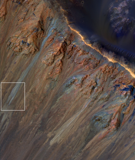
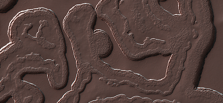
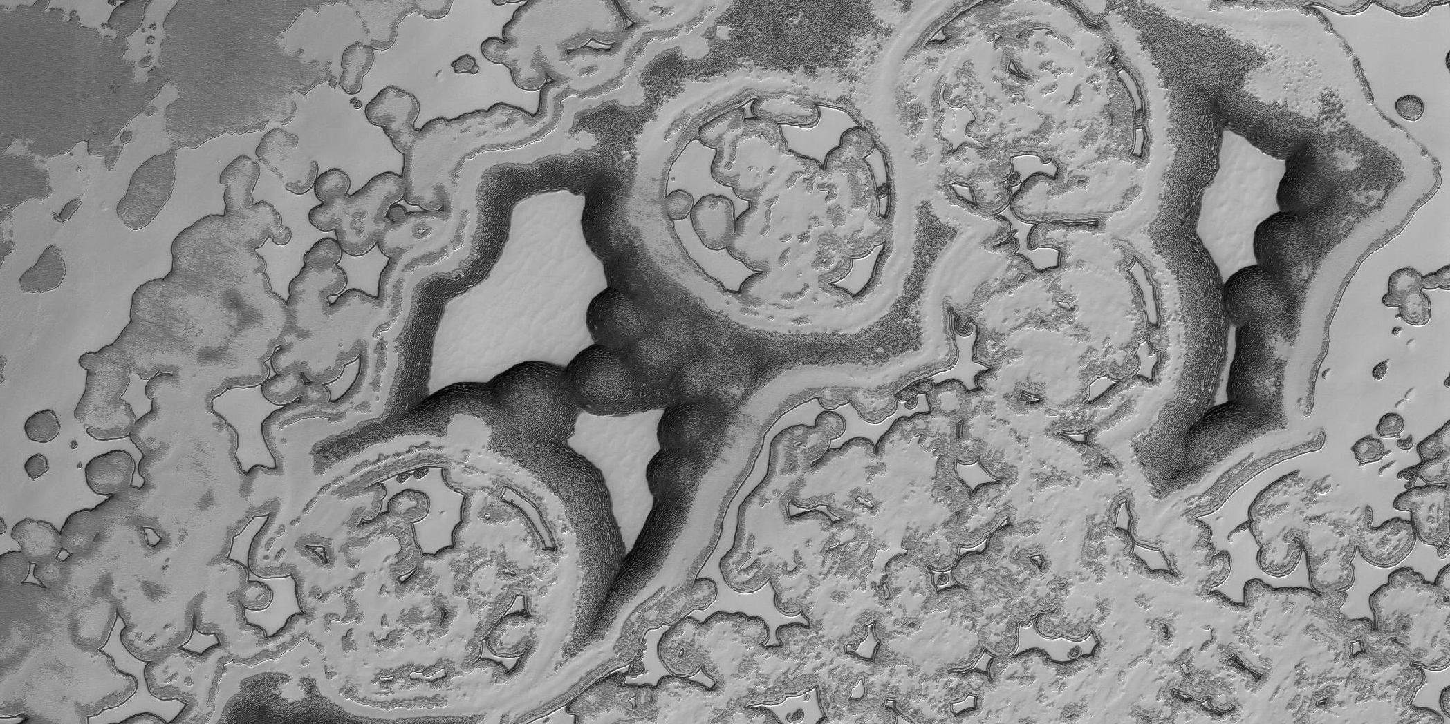
The mysterious dark splotches of Mars

The dark splotches of Mars

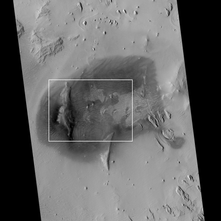
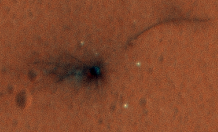
Cool image time! The image on the right, cropped and reduced in resolution to post here, shows one particular dark splotch in a region with several similar dark areas.

Geologists aren’t quite sure what to make of the dark splotch in the middle of this image, one of several similar dark splotches that extend east and west for over 100 kilometers. From measurements made in infrared, this and other dark splotches have what we call “high thermal inertia,” meaning that it heats up and cools down slowly. Scientists use thermal inertia to assess how rocky, sandy, or dusty a place is. A higher thermal inertia than the surrounding area means it’s less dusty.

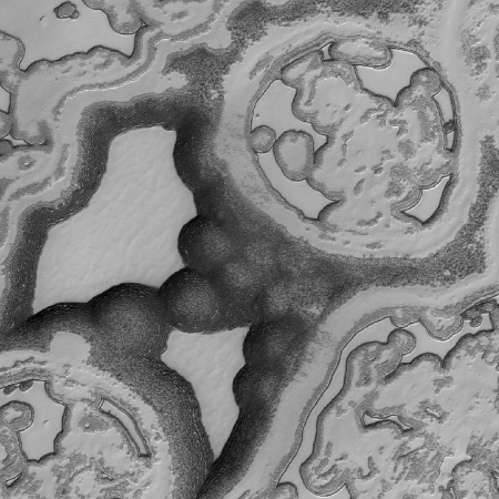
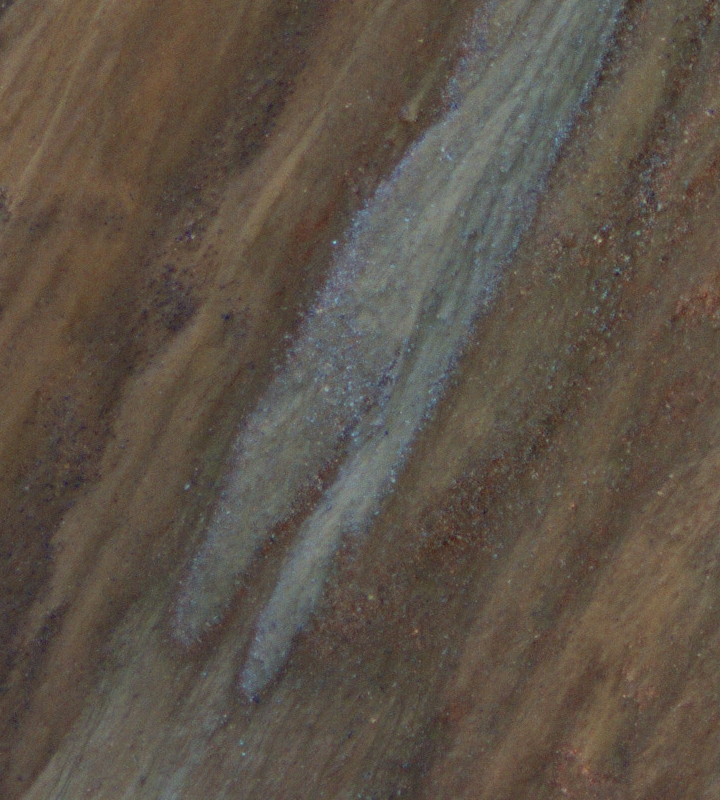
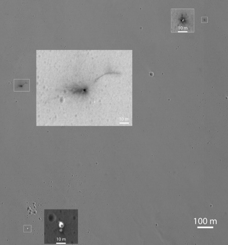
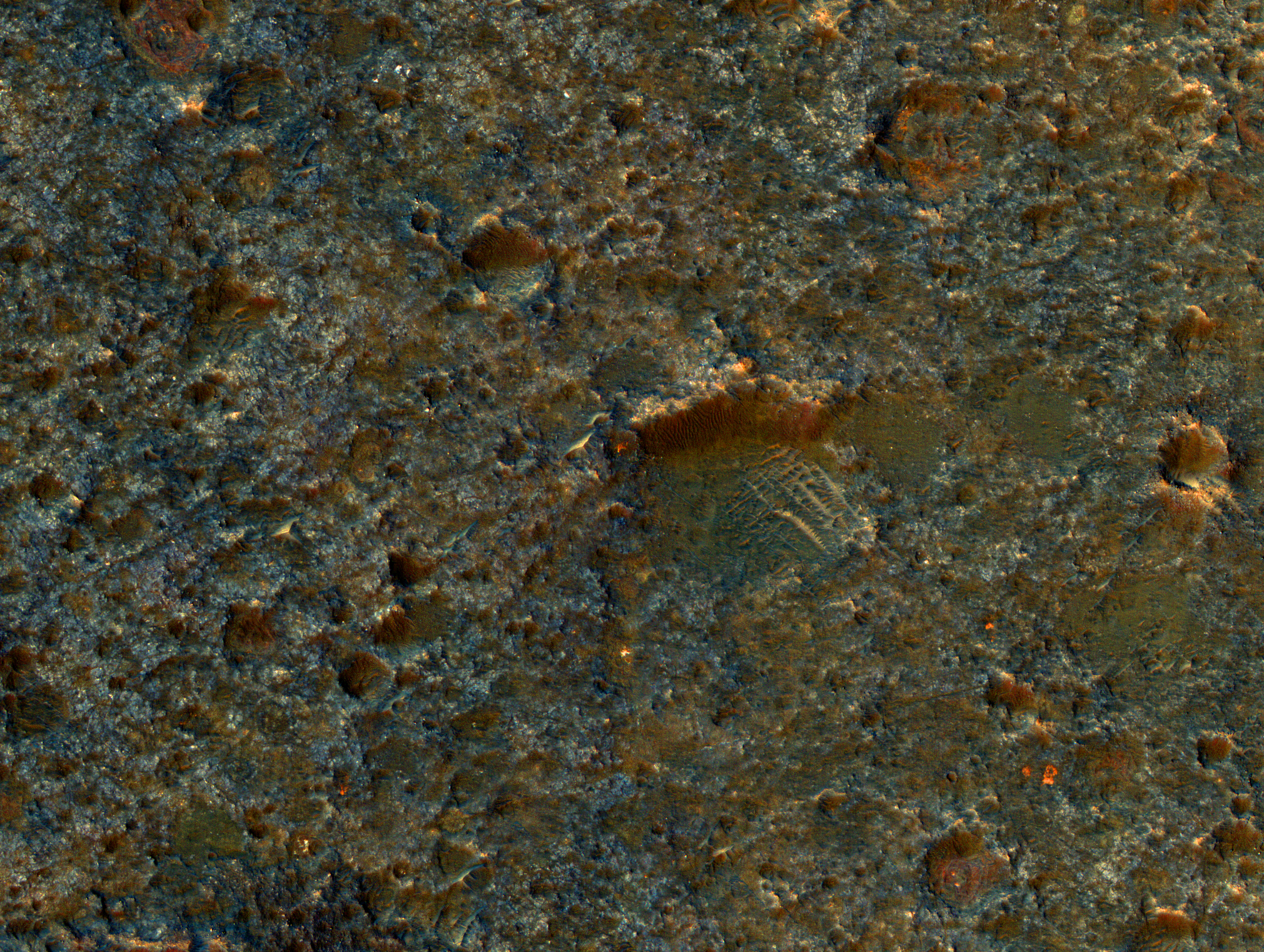
The image below the fold shows at full resolution the area indicated by the white box. It provides me no clue as to the cause for the darker color. I think we can speculate all we want, but the truth is that we simply don’t have enough information. We need a closer look, including boots on the ground, to figure this out.
» Read more

4 comments

Mars or a bacterial cell?

Mars's southern polar regions

Cool image time! The image on the right, reduced and cropped to show here, was taken by Mars Reconnaissance Orbiter and shows just one spot in Mars’s southern polar regions. The surface only looks like bacteria because the basic structure of both is based on fractals. Scientists call this area “swiss-cheese terrain” because of the many holes that have opened up there.

The texture is very alien, bearing more of a resemblance to the universe of the very small, rather than the universe far, far away. But if this is a polar cap, then why does it not look like the polar caps on Earth? Indeed, there is no equivalent terrain observed here on Earth.

The so-called “Swiss cheese terrain,” referencing the numerous holes of the region, is a product of seasonal exchange between the surface and the Martian atmosphere. With a predominantly carbon dioxide content at 98 percent, the colder temperatures condense the gas out of the atmosphere to produce dry ice. The prevalence of water is more concentrated in the north, leaving the South polar region more carbon dioxide rich, and it’s this difference in composition that generates the unusual texture of the Swiss cheese terrain.

Be sure and take a look at the full resolution image. It is quite wild.

1 comment

A Martian Journey

The exploration of the solar system has barely begun. Though we regularly get to see some spectacular images taken by the fleet of unmanned planetary probes that now circle or rove the various planets throughout the solar system, we mustn’t think we have seen very much. In truth, we have only gotten a very distant glimpse of only a few tiny spots, most of which have been viewed from very far away. Even at the highest resolution the images do not really tell us what it really will be like when we can stroll across those surfaces routinely.

To give you an idea of how much remains hidden, let’s take a journey inward from Mars orbit. The image below looks down on a good portion of the Martian globe, with the giant volcano Olympus Mons on the left, its three companion volcanoes in line to the east, and the vast valley of Valles Marineris east of these. This valley would cover the continental United States almost entirely, and extend significantly beyond into the oceans on either side.

Olympus Mons and Valles Marineris

This was essentially our first good look at Mars, taken from orbit by Mariner 9 in 1971.
» Read more

2 comments

Near the Martian south pole

Near the Martian south pole

Cool image time! The image above, reduced and cropped to show here, shows an area at 87 degrees south latitude, not far from the south pole of Mars and in the region at the edge of its icecap of dry ice.

It is late summer in the Southern hemisphere, so the Sun is low in the sky and subtle topography is accentuated in orbital images.

We see many shallow pits in the bright residual cap of carbon dioxide ice (also called “Swiss cheese terrain”). There is also a deeper, circular formation that penetrates through the ice and dust. This might be an impact crater or it could be a collapse pit.

Because of the low Sun angle the bottom of the deep pit is poorly lit, making it hard to determine the pit’s nature. What can be seen at its bottom however are some patches of carbon dioxide ice, melting in the same manner as the dry ice in the surrounding terrain. Also, the dust pattern surrounding the pit indicates the prevailing winds at this location, consistently blowing to the northeast.

I am certain there will be additional photos taken of this pit, when the Sun is higher in the sky and its floor is thus better illuminated.

5 comments

The soft avalanches of Mars

Krupac Crater gullies

Cool image time! The image on the right, reduced in resolution to show here, shows the gullies flowing down Krupac Crater on Mars. Be sure to check out the original, released today by the Mars Reconnaissance Orbiter science team, since they have enhanced the colors to bring out the sandy flows, noting as well that while most of these gullies are found in higher latitudes, this crater at 7.8 latitude has them as well.

Although large gullies (ravines) are concentrated at higher latitudes, there are gullies on steep slopes in equatorial regions. An enhanced-color closeup shows part of the rim and inner slope of Krupac Crater located just 7.8 degrees south of the equator.

The colors of the gully deposits match the colors of the eroded source materials. Krupac is a relatively young impact crater, but exposes ancient bedrock. Krupac Crater also hosts some of the most impressive recurring slope lineae (RSL) on equatorial Mars outside of Valles Marineris.

Below I have cropped out a small section showing, at full resolution, the termination point of one of these flows, indicating where this section is on the larger image to the right. This avalanche is clearly not liquid, though it has a very sandy and soft nature, suggesting — as some scientists have theorized — that liquid from below the surface might have played a part in its flow.

It is important in looking at these images to repeatedly remind yourself that the gravity here is about one third that of Earth, and thus the angle of repose will be different, and that avalanches will behave very differently in this environment. Moreover, Mars’s far colder climate will also effect things. The avalanche we are looking at could not happen in this way on Earth.

close-up of flow

10 comments

Strange beat-up Martian terrain

Strange terrain

Cool image time! The image above, taken by Mars Reconnaissance Orbiter and cropped to show here, reveals some very strange terrain, pounded by numerous impacts. The full color-enhanced image, which only covers a small area of the much larger strip image, shows a rough surface that on Earth would definitely be labeled “badlands.”

The very tiny cropped section above especially intrigued me because of the pronounced cliff that appears to be the north wall of a crater in which the east, west, and south walls have eroded away. The riverlet-like flows down the cliff-face are also intriguing, as are the cross-crossing features in the crater floor.

Make sure you look at the full images. Quite strange and fascinating. Even though the complete image strip isn’t color enhanced. it is filled with many interesting geological forms. I haven’t yet been able to find the spot shown by the color-enhanced section, but it is there nonetheless. I wonder if any of my readers can locate it.

2 comments

The Earth and Moon, as seen from Mars

The Earth and Moon as seen from Mars

Cool image time! The image above, a composite of four separate Mars Reconnaissance Orbiter pictures, was taken on November 20, 2016.

Each was separately processed prior to combining them so that the moon is bright enough to see. The moon is much darker than Earth and would barely be visible at the same brightness scale as Earth. The combined view retains the correct sizes and positions of the two bodies relative to each other.

The reddish region on Earth is Australia, with Antarctica the bright white area below that.

9 comments

Lace on Mars

Lace on Mars

Cool image time! The image on the right, cropped and reduced in resolution to show here, was taken by Mars Reconnaissance Orbiter June 21, 2016. It shows a region in the high northern latitudes, 80 degrees.

Some seasonal ice on Mars is transparent so that the sunlight penetrates to the bottom of the ice. Heat from this sunlight can turn the ice directly into a gas in a process called sublimation and this gas can scour channels in the loose dirt under the ice. Channels formed by sublimation of a layer of seasonal dry ice are so dense in this area that they look like lace. Gas flow erodes channels as it escapes to the surface of the overlying seasonal ice layer seeking the path of least resistance.

The resolution of the full image is 9.7 feet per pixel. This means that if Curiosity was driving across this surface we would see it. I guarantee however that Curiosity would not find driving here very easy. The ice surface is likely very delicate, and would likely cause any vehicle to bog down. The surface is also likely very alien-looking, which makes me very much want to see what it looks like, up close. This look will unfortunately have to wait, as we as yet do not have the right technology to do it. We would need I think a drone, capable of flying in Mars’s thin atmosphere.

0 comments

The weird south pole of Mars

Mars' south pole region

Cool image time (literally)! The photo above, cropped slightly to show here, was taken by Mars Reconnaissance Orbit (MRO) in August 2016 and was released today as part of the monthly release of captioned images. And though it looks like a fractal computer-generated animation still, it is instead real, showing the strange and quite alien terrain that routinely forms at the carbon dioxide ice cap there.

The polar cap is made from carbon dioxide (dry ice), which does not occur naturally on the Earth. The circular pits are holes in this dry ice layer that expand by a few meters each Martian year. New dry ice is constantly being added to this landscape by freezing directly out of the carbon dioxide atmosphere or falling as snow. Freezing out the atmosphere like this limits how cold the surface can get to the frost point at -130 degrees Celsius (-200 F). Nowhere on Mars can ever get any colder this, making this this coolest landscape on Earth and Mars combined!

This region is about 4 degrees north of the south pole itself.

6 comments

MRO color images of Schiaparelli crash site

Schiaparelli crash site

The image above, cropped from a wider image released today by the Mars Reconnaissance Orbiter science team, shows the Schiaparelli impact sites in color and in very high resolution. There are also high resolution images of the heat shield and parachute/back shell. As they note in describing the above image,

Where the lander module struck the ground, dark radial patterns that extend from a dark spot are interpreted as “ejecta,” or material thrown outward from the impact, which may have excavated a shallow crater. From the earlier image, it was not clear whether the relatively bright pixels and clusters of pixels scattered around the lander module’s impact site are fragments of the module or image noise. Now it is clear that at least the four brightest spots near the impact are not noise. These bright spots are in the same location in the two images and have a white color, unusual for this region of Mars. The module may have broken up at impact, and some fragments might have been thrown outward like impact ejecta.

In other words, the lander crashed hard when it hit the ground, throwing pieces and ground material everywhere.

1 comment

New details emerge of Schiaparelli crash site

Schiaparelli crash site

A new high resolution image from Mars Reconnaissance Orbiter’s HIRISE camera, reduced in resolution on the right, confirms that Schiaparelli crashed into the ground on October 19.

The scene shown by HiRISE includes three locations where hardware reached the ground. A dark, roughly circular feature is interpreted as where the lander itself struck. A pattern of rays extending from the circle suggests that a shallow crater was excavated by the impact, as expected given the premature engine shutdown. About 0.8 mile (1.4 kilometers) eastward, an object with several bright spots surrounded by darkened ground is likely the heat shield. About 0.8 mile (1.4 kilometers) south of the lander impact site, two features side-by-side are interpreted as the spacecraft’s parachute and the back shell to which the parachute was attached.

The center insert is a close-up of the impact site on the left, which clearly shows that the lander hit the ground hard, producing impact ejecta. That the rays are somewhat asymmetric also suggests that Schiaparellit hit the ground at an oblique angle.

12 comments

MRO images Schiaparelli on Mars

before and after Schiaparelli

A comparison of images taken by Mars Reconnaissance Orbiter before and after Schiaparelli’s failed attempt to land on Mars have revealed changes that are likely the lander on the surface. The image on the right is a composite that I’ve made showing the two images. The black spot near the top and the white spot near the bottom are not in the first image.

It is thought that the white spot is likely Schiaparelli’s parachute, while the dark spot is thought to be the lander’s impact point.

The larger dark spot near the upper edge of the enlargement was likely formed by the Schiaparelli lander. The spot is elliptical, about 50 by 130 feet (15 by 40 meters) in size, and is probably too large to have been made by the impact of the heat shield.

The large size of the dark spot suggests that the lander hit the ground hard enough to create this large scar.

3 comments
1 85 86 87 88 89 90