The dark streaks on Mars are water

New data strongly suggests that that the seasonal dark streaks scientists have imaged running down crater slopes on Mars are heavily salted water.

The salt allows the water to flow by lowing its freezing point. The new data has confirmed the presence of those salts, strengthening the theory that the seasonal streaks are water, possibly seeping from beneath the surface or condensing out of the atmosphere.

22 comments

Mangalyaan in great shape

The competition heats up: With their Mangalyaan Mars orbiter about to celebrate the completion of its first year in Mars orbit, Indian scientists noted this week that the spacecraft is in great shape and can function for years to come.

They have a large reserve of fuel on board and there are no known technical issues.

0 comments

Petrified sand dunes on Mars

Petrified sand dunes on Mars

Cool image time! A panorama produced from images taken by Curiosity’s Mast camera has revealed the remains of ancient sand dunes, cemented into sandstone and now eroding.

This sandstone outcrop — part of a geological layer that Curiosity’s science team calls the Stimson unit — has a structure called crossbedding on a large scale that the team has interpreted as deposits of sand dunes formed by wind. Similar-looking petrified sand dunes are common in the U.S. Southwest. Geometry and orientation of the crossbedding give information about the directions of the winds that produced the dunes.

The Stimson unit overlies a layer of mudstone that was deposited in a lake environment. Curiosity has been examining successively higher and younger layers of Mount Sharp, starting with the mudstone at the mountain’s base, for evidence about changes in the area’s ancient environment.

The image above is cropped and reduced in resolution. Be sure to look at the original.

This report also suggests that Curiosity is definitely moving up the geological layers on Mount Sharp. With each layer, we learn a little bit more about the complex geological history of Gale Crater.

1 comment

Martian floods regional, not global

Using the data accumulated from various modern Mars orbiters scientists now think that many of the Martian floods were caused by regional circumstances rather than a single global event.

“The flooding is due to regional processes, not global processes,” said Rodriguez, a Senior Scientist at the Planetary Science Institute and lead author of “Martian outflow channels: How did their source aquifers form, and why did they drain so quickly?” that appears in a Nature Scientific Report. “Deposition of sediment from rivers and glacial melt filled giant canyons beneath a primordial ocean contained within the planet’s northern lowlands. It was the water preserved in these canyon sediments that was later released as great floods, the effects of which can be seen today.”

The canyons filled, the Martian ocean disappeared, and the surface froze for approximately 450 million years. Then, about 3.2 billion years ago, lava beneath the canyons heated the soil, melted the icy materials, and produced vast systems of subterranean rivers extending hundreds of kilometers. This water erupted onto the now-dry surface in giant floods.

This theory suggests that Mars still has a great deal of trapped frozen water held in large underground reserves, available for future colonists. I like the fact that it also suggests that there were “vast systems of subterranean rivers extending hundreds of kilometers” where this frozen water was once stored and, having now melted, has left behind gigantic underground caverns.

0 comments

Engineers propose using SpaceX rocket and capsule to bring samples back from Mars

Engineering by powerpoint! Several NASA engineers have proposed using SpaceX’s Falcon Heavy rocket and an upgrade of its Dragon capsule to bring samples back from Mars.

The researchers have drawn up a plan that uses a modified version of SpaceX’s uncrewed Dragon cargo capsule, which has already flown six resupply missions to the International Space Station for NASA. The Red Dragon variant would include a robotic arm, extra fuel tanks and a central tube that houses a rocket-powered Mars Ascent Vehicle (MAV) and an Earth Return Vehicle (ERV).

Red Dragon would launch toward Mars atop SpaceX’s huge Falcon Heavy rocket, which is scheduled to fly for the first time next year. After a long deep-space journey, the capsule would touch down near the 2020 Mars rover (whose landing site has not yet been chosen). “Red Dragon can go anywhere the rover can go, as far as landing elevation and terrain,” Gonzales said. “We’re confident we could land in front of the rover and have it drive to us.”

Red Dragon’s robotic arm would then grab a sample from the rover’s onboard cache (assuming the 2020 rover does indeed carry its samples, rather than stash them someplace) and transfer it to a secure containment vessel aboard the ERV, which sits atop the MAV. If something goes wrong during this exchange, Red Dragon can simply scoop up some material from the ground using its arm. The MAV would then blast off from the center of the capsule, like a missile from a silo, sending the ERV on its way back to Earth. The ERV would settle into orbit around our planet; its sample capsule would then be transferred to, and brought down to Earth by, a separate spacecraft — perhaps another Dragon capsule.

I like this concept because it uses available or soon-to-be available resources that are also relatively cheap to adapt for the mission. I also warn everyone that this is, as I note above, engineering by powerpoint. It is a concept, hardly a real proposal. The track record of seeing these kinds of proposals by NASA actually happen is quite poor.

2 comments

Curiosity spots a spoon on Mars!

The spoon on Mars

Very cool image time! In one of Curiosity’s recent images of the Martian surface on the slopes of Mount Sharp appears what looks like a long thin spoon jutting horizontally out of the ground.

The shadow below the feature is strong evidence that that this almost certainly a real object, shaped exactly as we see it. However, it is not an artificially created spoon. If you look at both the full raw image as well as zoom in on the feature itself, you will see that it is something that formed naturally due to Mars’ low gravity and the geology here. The spoon is a thin prong of harder material that has remained intact as the ground below it has been slowly eroded away by the ever-present but very weak Martian wind. If you look close you can see that harder material extend back into the rock behind the spoon.

Some of that erosion might also have been caused by flowing water sometime in the past, but to confirm this will take additional geological research.

4 comments

A detailed status update on Mars Reconnaissance Orbiter

Link here. The orbiter, which continues to send down spectacular images while acting as a workhorse communications relay for the rovers on the ground, appears to be in reasonable shape. It has enough fuel to operate into the late 2020s. The other known problems appear manageable.

Zurek said the most significant technical issue aboard MRO is in one of the spacecraft’s inertial measurement units used to determine the orbiter’s motion and orientation. Zurek said a laser inside one of the unit’s gyroscopes is showing signs of aging, and ground controllers are trying to coax the sensor along by switching to an identical backup unit.

In the meantime, engineers are working on changing the orbiter’s navigation logic to rely on star trackers in case both navigation sensors go down, Zurek said. One of the gimbals used to point MRO’s power-generating solar panels toward the sun is also sticky, a sign of age-related “arthritis” aboard the spacecraft, Zurek said.

MRO also abruptly switches to its backup “B side” computer on occasion, temporarily interrupting scientific observations for a few days each time. Zurek said the orbiter’s ground team has learned to deal with the problem, which has escaped diagnosis with a root cause.

Of course, there are always the unknown problems that haven’t yet popped up that could be devastating. Let us hope none appear soon, since NASA will not be able to send a replacement until 2022, at the earliest.

0 comments

The wild Martian terrain

Yardangs on Mars

This week’s image release from the high resolution camera on Mars Reconnaissance Orbiter illustrate well the wild and mysterious geology of the Martian surface. I include cropped sections from two images here, just to give you a taste. Go to the link to do your own exploring.

The image to the right is a cropped and scaled down version of the original image, so the details are not easily seen. Make sure you look at the original. The strange yardang ridges, all aligned alike, rise up out of a relatively smooth plain.

Yardangs are formed when a surface that is composed of materials of differing strengths (i.e., of both harder and softer materials) is shaped by the abrasive action of sand and dust carried by the wind. In this case, and given the proximity of the Apollonaris Patera volcanic center, we think that these wind-carved deposits are comprised of volcanic ash and pyroclastics that erupted from Apollonaris when it was last active in the not-too-distant geologic past. Over time, the softer materials (likely volcanic ash) were eroded away, leaving behind the harder materials in the form of elongated ridges that are parallel to the direction of the prevailing wind. The end result is a stunning, out-of-this-world display of yardangs, sculpted with the artistic chisel of the Martian wind.

That’s the theory, anyway. The actual geological process that formed these ridges is probably a lot more complicated.

The image below the fold illustrates the on-going surface activity on Mars.
» Read more

0 comments

Scientists narrow the next Mars rover candidate landing sites to 8

Jezero Crater

For the next Mars rover, scheduled to launch in 2020, scientists have now narrowed their candidate landing sites to eight, with Jezero Crater (pictured on the right) the favorite choice.

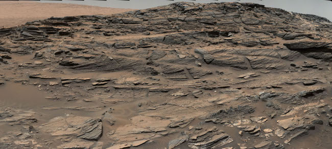
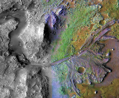
The top vote getter was Jezero crater, which contains a relic river delta that could have concentrated and preserved organic molecules. “The appeal is twofold,” says Bethany Ehlmann, a planetary scientist at the California Institute of Technology (Caltech) in Pasadena. “Not only is there a delta, but the rocks upstream are varied and diverse.”

The image clearly shows the scientific attraction of Jezero Crater, with an obvious meandering river canyon opening out into an obvious river delta. The crater in the delta will also give them an opportunity to do some dating research, since that crater had to have been put there after the delta was formed.

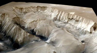
The choice however illustrates the difference in goals between scientists and future colonists. Scientists are looking for the most interesting locations for understanding the geological history of Mars. Future colonists want to find the best places to establish a home. Jezero Crater, as well as the other eight candidate sites, do not necessarily fit that settlement need. For a colonist it might be better to put a rover down on the flanks of Arsia Mons, one of Mars’ giant craters where scientists have evidence of both water-ice and caves. None of the candidate sites, however, are aimed anywhere close to this volcanic region, because scientifically it is not as interesting.

This is not to say that the candidate sites might not be good settlement sites. It is only to note that the focus of these scientists is research only. Furthermore, it is probably premature anyway to look for settlement sites. We need to know more about Mars itself.

2 comments
1 174 175 176 177 178 212