Solid dry ice in Moon’s permanently shadowed craters?

Stable dry ice at Moon's south pole
Click for full figure.

Using eleven years of data from Lunar Reconnaissance Orbiter (LRO), scientists think they have identified small areas in the Moon’s permanently shadowed interiors of some polar craters where the temperatures are always cold enough for dry ice (solid carbon dioxide) to be stable.

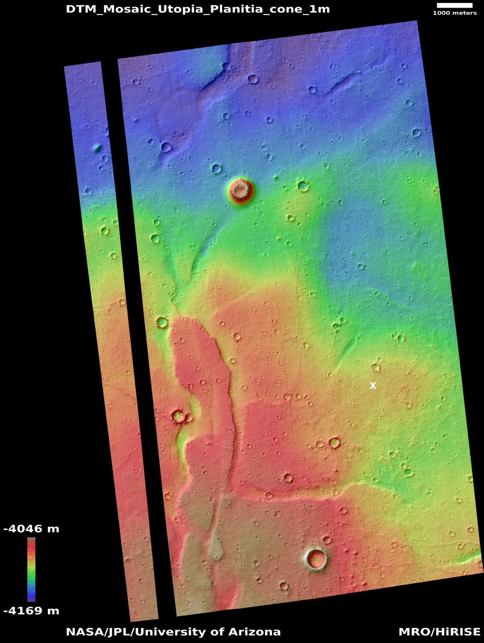
The map to the right, cropped and reduced to post here, is Figure 2 of the paper. It shows the areas at the south pole where stable dry ice is thought possible. The darker blue/purple are colder and thus are expected to have less sublimation. From the abstract:

Carbon-bearing species would be essential for sustained robotic or human presence on the Moon, for use in rocket fuel and biological materials. Various volatiles can be cold-trapped in permanently shadowed craters near the lunar poles. The existence of carbon dioxide cold traps has previously been surmised, but the required temperatures are near the lowest surface temperatures that have been reliably measured. Extensive and improved analysis of 11 years of orbital surface temperature measurements establishes the existence of carbon dioxide cold traps on the Moon, which potentially host high concentrations of solid carbon dioxide. Large CO2 cold traps are rare, however, and the geographic concentration of the resource will have policy implications. [emphasis mine]

The paper also adds in its conclusion that these regions are likely going to be of high value, and will thus likely be prime settlement and mining targets by everyone. As they note, “That this resource is highly concentrated geographically has implications for the governance of the lunar surface.”

5 comments

Major solar flare from the Sun

X-1 solar flare
The flare is the bright spot, center bottom. Click for original image.

The Sun today unleashed an X1-class solar flare, one of the more powerful seen since the ramp up to solar maximum began at the start of 2020.

More information here, with this quote:

The blast also hurled a CME [coronal mass ejection] into space. Coronagraph images are not yet available, but evidence for a CME is already pursuasive [sic]. The USAF reports strong Type II and Type IV radio emissions generated by a CME plowing through the sun’s atmosphere. In addition, energetic particles accelerated at the leading edge of a CME have already reached Earth.

When will the CME itself arrive? Assuming that it is Earth directed, probably on Oct. 30th or 31st. Fresh data from SOHO coronagraphs will allow a more precise forecast, so stay tuned.

During the flare, a pulse of X-rays and extreme UV radiation ionized the top of Earth’s atmosphere, causing a strong shortwave radio blackout centered on South America:

Aviators, mariners, and ham radio operators on the daylit side of Earth may have noticed strange propagation effects at frequencies below 30 MHz.

While this flare is unlikely to cause any significant disturbances to orbiting or Earth-based technology, the flare was emitted by a large sunspot that is still active, can still flare again, and is well positioned on the Sun to send more material and radiation Earthward.

1 comment

New results about Jupiter published from Juno

Three new papers published today in the journals Science and the Journal of Geophysical Research: Planets reveal in more detail the depth of Jupiter’s storms and clouds, using a variety of different sensors and techniques.

The papers can be found here, here, and here.

Juno’s microwave radiometer (MWR) allows mission scientists to peer beneath Jupiter’s cloud tops and probe the structure of its numerous vortex storms. The most famous of these storms is the iconic anticyclone known as the Great Red Spot. Wider than Earth, this crimson vortex has intrigued scientists since its discovery almost two centuries ago.

The new results show that the cyclones are warmer on top, with lower atmospheric densities, while they are colder at the bottom, with higher densities. Anticyclones, which rotate in the opposite direction, are colder at the top but warmer at the bottom.

The findings also indicate these storms are far taller than expected, with some extending 60 miles (100 kilometers) below the cloud tops and others, including the Great Red Spot, extending over 200 miles (350 kilometers). This surprise discovery demonstrates that the vortices cover regions beyond those where water condenses and clouds form, below the depth where sunlight warms the atmosphere.

The height and size of the Great Red Spot means the concentration of atmospheric mass within the storm potentially could be detectable by instruments studying Jupiter’s gravity field. Two close Juno flybys over Jupiter’s most famous spot provided the opportunity to search for the storm’s gravity signature and complement the MWR results on its depth.

With Juno traveling low over Jupiter’s cloud deck at about 130,000 mph (209,000 kph) Juno scientists were able to measure velocity changes as small 0.01 millimeter per second using a NASA’s Deep Space Network tracking antenna, from a distance of more than 400 million miles (650 million kilometers). This enabled the team to constrain the depth of the Great Red Spot to about 300 miles (500 kilometers) below the cloud tops.

The data from these two techniques confirms that the base of the Great Red Spot is somewhere between 200 to 300 miles below the cloud tops, much deeper than most of the other storms, though even those storms are deeper than expected.

Another paper published earlier in Geophysical Research Letters looked at the storms in Jupiter’s polar regions, and found their polygonal arrangement around the poles appears stable and caused by a balanced push between these surrounding storms, trying to move to the poles, and the storms at the poles pushing back.

0 comments

One last look at a Martian mountaintop

Siccar Point
For the original images go here and here.

The image above is a mosaic made from two Curiosity navigation photos taken on October 23, 2021 and combined, cropped, and reduced to post here. It shows the top 30 feet or so of Siccar Point, the spectacular outcrop that I have featured several times previously.

Curiosity has now traveled past this outcrop, so that this view above is no longer visible to the rover. I post it now as a farewell image of what I think is the most breath-taking feature yet seen by any planetary lander — manned or unmanned — since the first set down on the Moon in the mid-1960s. It also illustrates with great clarity the alien nature of Mars. Those delicate overhanging rocks would not be possible on Earth, with a gravity about two and a half times heavier than Mars.

Note too that I have not enhanced the contrast or brightness. I think the twilight light here actually gives us a sense of the real brightness of a clear Martian day. Because the Sun is much farther away, even at high noon it provides much less illumination than on Earth. A bright day on Mars to our Earth-adapted eyes will always feel like dusk.

Meanwhile the science team is quickly pushing the rover south, to get…

…closer to the area we are targeting for our next drill campaign. This drive should leave us with bedrock in the workspace for additional contact science on the weekend. This terrain continues to be very challenging, with large boulders, sharp rocks that are wheel hazards, and sand ripples, like the terrain shown in the image. These drives take a while to plan to make sure we are avoiding all the hazards while getting to where science wants to go. Our paths end up looking a little “drunk” as we weave our way around obstacles.

7 comments

Curiosity marches on into the mountains

Curiosity marches onward to Maria Gordon Notch
Click for full image.

Overview map
Click for interactive map

With the end of the solar conjunction in the first half of October, blocking communications with Mars because the Sun was in the way, Curiosity has resumed its travels. It has moved past the spectacular outcrop I have highlighted previously, an outcrop the science team has labeled Siccar Point.

They are now moving south at the base of the cliff to the west, the top of which is a plateau they call the Greenheugh Pediment, heading for a gap where the rover will be able to turn right and head up onto that pediment. The red dotted line on the overview map to the right shows this route, which corresponds to the red dotted line on the photo above.

I estimate the cliffs on both sides of Maria Gordon Notch are about 100 feet high. The notch itself I estimate is about 750 feet away. At the pace Curiosity has been traveling across this rough ground, it could probably reach it in about two to three weeks. However, I expect the science team will stop at least once along the way to do more detailed science work, so that journey might take a month or slightly more.

0 comments

Water and carbon monoxide detected in exoplanet’s atmosphere

Astronomers, using both the Hubble Space Telescope and the ground-based Gemini Telescope, have detected water and carbon monoxide in the atmosphere of an exoplanet 320 light years away.

Previously hydrogen, helium, hydrogen cyanide, iron, and magnesium have been detected in the atmospheres of a variety of exoplanets. In other cases scientists found exoplanets that were devoid of water.

This detection of water and carbon monoxide is a first for these two materials, and is somewhat significant as it is the first detection that suggests an exoplanet atmosphere that might have similarities to Earth.

0 comments

Ingenuity completes 14th flight on Mars

Ingenuity's shadow below it during 14th flight
Ingenuity’s shadow below it during 14th flight.
Click for full image.

On October 24th, Ingenuity successfully completed its 14th flight on Mars, a short test hop up and down to see if the helicopter could function properly as the air pressure in the Martian atmosphere drops due to seasonal variations.

As planned, the helicopter executed its first 2,700 rpm flight, proving that Ingenuity is capable of flying in the weeks and months ahead on Mars, during which seasonal changes on the surface will result in decreases in air density. The short 23-second flight included a peak altitude of 16 feet (5 meters) above ground level, with a small sideways translation of 7 feet (2 meters) to avoid a nearby sand ripple.

I predict the next flight will head north, leap-frogging past Perseverance to get a better view of the South Seitah area so that the rover team can decide whether they can continue north through that terrain or retreat backwards.

0 comments

How deadly is COVID-19, really?

It is now almost twenty months since COVID-19 crossed the ocean from China and arrived in the United States. When it arrived there was great fear as its true deadliness at that time was unknown. Though the sparse data from China, South Korea, and the Diamond Princess cruise ship suggested it was merely a variation of the annual flu and not something to fear, the computer models put forth by a variety of scientific institutions at that time instead predicted millions were about die from it.

No one really knew for certain. Some legitimately argued that the lockdowns, mask mandates, and oppressive restrictions on normal activities were necessary to limit its harm.

Almost two years have now passed, and we can now assess realistically which of those scenarios was accurate. To best understand these things I strongly believe is always best to look at the big picture, the larger and bigger the better. In this case, let’s look at the entire U.S. and measure COVID-19’s impact by noting the total number of people in the United States who have become infected by COVID since its arrival and comparing that with the total number who have died. These actual numbers will tells us truly how deadly COVID has been, and whether our continued fear of it is justified.

CDC COVID estimates as of May 2021
CDC’s COVID-19 estimates as of May 2021

According to CDC estimates, as of May 2021, 120.2 million Americans had been infected by COVID, of which 101.8 million experienced actual symptoms. The CDC in these same estimates in May calculated that 767,000 people had died from COVID.

These CDC estimates were further supported by a Nature peer review study published in August 2021, which estimated that by the end of 2020 100 million Americans had been infected with COVID.
» Read more

40 comments

China resumes communications with Zhurong Mars rover

Elevation map of Zhurong location
Click for full image.

The new colonial movement: China yesterday announced that it has regained communications with its Zhurong rover, located in the Martian northern lowland plains of Utopia Planitia.

The image to the right, cropped and annotated by me to post here, is a digital terrain map created from two high resolution photos taken by Mars Reconnaissance Orbiter (MRO). The black line shows the route Zhurong has traveled since landing in May.

According to [Chen Baichao, the chief designer of Zhurong], the rover has traveled more than 1,000 meters since it landed on Mars at the southern part of Utopia Planitia in May 2021. After the solar conjunction, it will head south to find mud volcanoes, which scientists are interested in, located about 10 km away.

American scientists had hoped Zhurong would head north to a much larger mud cone that was much closer. Their decision to head south to the smaller cones farther away tells us that they have given themselves a much more challenging mission. It also suggests they decided it will be easier to get Zhurong closer to a smaller cone.

Based on that 10 kilometer distance, it seems the Chinese are aiming for the cones near the bottom of the map. It took Zhurong three months to travel the distance shown. At that pace, to get to those small southern mud cones will likely take, at a minimum, about fifteen months. Though the ground is quite flat, the rover will either have to negotiate one small rise of about 15 feet, or detour to the east somewhat to find a less steep route.

It is also possible that they will instead head to the mud cone south of the large impact crater. It is also a small cone, is much nearer, and will not require them to get past that rise.

4 comments

Firefly approves design of its unmanned lunar lander

Capitalism in space: Firefly has completed and approved the design of its unmanned lunar lander, and will now begin construction with a launch date targeting 2023.

Firefly said Monday that it has completed the “critical design review” phase of its program to develop a lunar lander. This means the company can now proceed to build and order components for the “Blue Ghost” spacecraft and begin its assembly. Firefly aims to launch the spacecraft as the primary payload on a Falcon 9 rocket in the fall of 2023.

NASA is sponsoring the mission as part of its Commercial Lunar Payload Services Program, through which it pays private companies to deliver scientific experiments to the Moon. NASA is paying $93.3 million for this Blue Ghost mission, which will carry 10 payloads down to the Mare Crisium lunar basin in September 2023.

In the next three years a plethora of commercial unmanned lunar landers have scheduled flights, all bringing both NASA science as well commercial payloads to the lunar surface. All are being designed and built by private companies. Expect some to fail. Some however will succeed, and will thus establish themselves as the go-to companies if you want to put a payload on the Moon.

0 comments

Layered glaciers in Mars’ glacier country

Layered glacier in Mars' glacier country
Click for full image.

Cool image time. The photo to the right, cropped and reduced to post here, was taken on August 30, 2021 by the high resolution camera on Mars Reconnaissance Orbiter (MRO). It shows two different impact craters in a glacial region dubbed Nilosyrtis Mensae, located in the northern mid-latitudes in the 2,000 mile long strip chaos terrain that I have labeled glacier country because practically every image finds them there.

The splash apron surrounding the larger crater is typical of craters in Martian regions where ice is thought to be near the surface.

What makes this picture interesting is that the glaciers appear layered. You can see evidence of this in the mounds inside both craters. Those mounds appear to represent earlier periods when there was more ice here. Since then the mounds have partly sublimated away.

You can also see evidence of layers in the material surrounding the nearby larger mounds.

The map below shows us where this image is, relative to all of glacier country as well as the rover Perseverance in Jezero Crater.
» Read more

0 comments

Today’s blacklisted American: Doctor fired for refusing vaccine

The modern dark age: Mollie James, an ICU doctor working jobs in hospitals in both St. Louis and New York, was forced to leave her hospital practices because she refused to get vaccinated against COVID because she already had natural immunity.

From the Nebraska AG report
The Nebraska AG’s doubts about remdesirvir.

In addition, James was also forced out because she researched the use of ivermectin, tried it on her patients, and found it beneficial. Her desire to prescribe it to her sick patients however was blocked by her hospitals, who insisted instead that she prescribe remdesivir, an anti-viral drug that the government pays a premium for hospitals to use, but has been shown to be of doubtful benefit [see screen capture to the right].
» Read more

7 comments
1 209 210 211 212 213 729