According to a new very detailed engineering analysis into the causes of the collapse of the Arecibo radio telescope in Puerto Rico in 2020, the failure was caused first by a surprising interaction between the radio electronics of Arecibo and the traditional methods used to anchor the cables, and second by a failure of inspections to spot the problem as it became obvious.
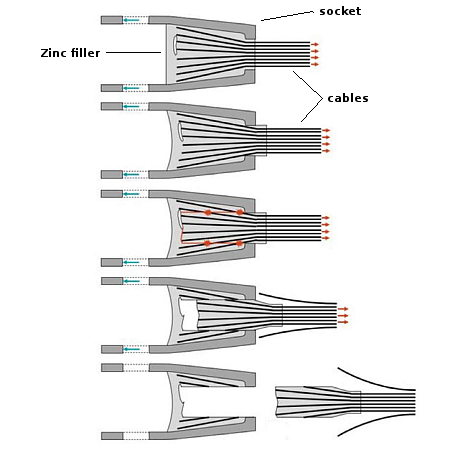
The surprising engineering discovery is illustrated to the right, taken from figure 2-6 of the report. The main antenna of Arecibo was suspended above the bowl below by three main cables. The figure shows the basic design of the system used to anchor the cable ends to their sockets. The end of the cable bunches would be inserted into the socket, spread apart, and then zinc would be poured in to fill the gap and then act as a plug and glue to hold the cables in place. According to the report, this system has been used for decades in many applications very successfully.
What the report found however was at Arecibo over time the cable bunch and zinc plug slowly began to pull out of the socket, what the report labels as “zinc creep.” This was noted by inspectors, but dismissed as a concern because they still believed the engineering margins were still high enough to prevent failure at this point. In fact, this is exactly where the structure failed in 2020, with the first cable separating as shown in August 2020. The second cable did so in a similar manner in November 2020.
The report concluded that the “only hypothesis the committee could develop that provides a plausible but unprovable answer to all these questions and the observed socket failure pattern is that the socket zinc creep was unexpectedly accelerated in the Arecibo Telescope’s uniquely powerful electromagnetic radiation environment. The Arecibo Telescope cables were suspended across the beam of ‘the most powerful radio transmitter on Earth.'”
The report however also notes that the regular engineering inspections of the telescope had spotted this creep, which was clearly unusual and steadily becoming significant, and did not take action to address the issue when it should have. It also noted the slow response of the bureaucracy, not only to the damage caused earlier to the facility by Hurriane Maria in 2017, but to obtaining the funding for any repairs.
Ray Lugo [the principal investigator for Arecibo] described to the committee how months of his time during 2018 were spent writing, resubmitting, and justifying repair funding proposals. Repairs had to go through the traditional “bid and proposal” process, described in more detail below, which added years of delay.
We can forgive the inspectors somewhat for not noting the creep when they should, as its cause appears to be very unusual, still uncertain and rare, but the red tape that prevented proper and quick repair effort after the hurricane is shameful. Had the telescope gotten the proper support on time, the creep itself might have even been addressed, because the resources would have been there to deal with it.


