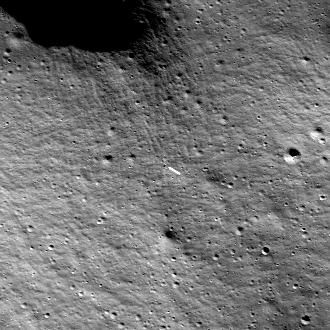
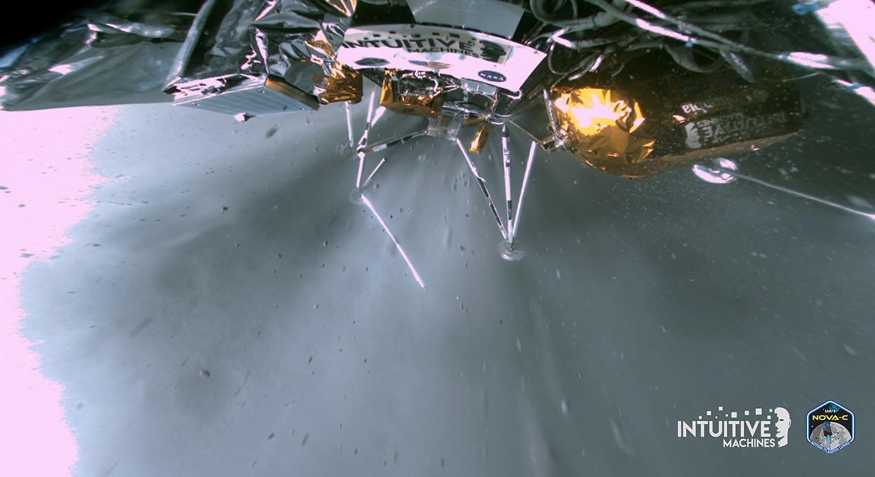
Odysseus appears to have landed successfully

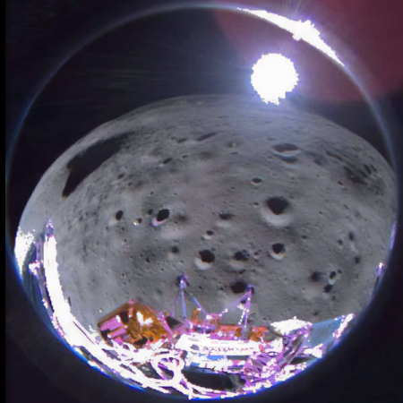
The privately built Odysseus lunar lander appears to have landed successfully near the south pole of the Moon, though ground controllers have not yet gotten full confirmation that all systems are functioning.

As stated by the mission director, after noting that they were getting a faint signal from the lander’s high gain antenna:

All stations, this is mission director on IM-1. We are evaluating how we can refine that signal and dial in the pointing for our dishes. What we can confirm without a doubt is that our equipment is on the surface of the Moon and we are transmitting. So congratulations IM team. We’ll see how much more we can get from that.

Shortly thereafter the company and NASA ended the live stream.

At this time they do not yet know exactly where the lander touched down, or whether it did so without damage. The signal from the high gain antenna suggests the communications system is intact as well as the antenna, but the lack of further confirmation suggests damage to other instruments, though it is also possible that the signal is not yet firm enough to obtain data from other instruments.

More updates to follow, without doubt.

15 comments

Frozen lava rapids on Mars

Frozen lava rapids on Mars
Click for original image.

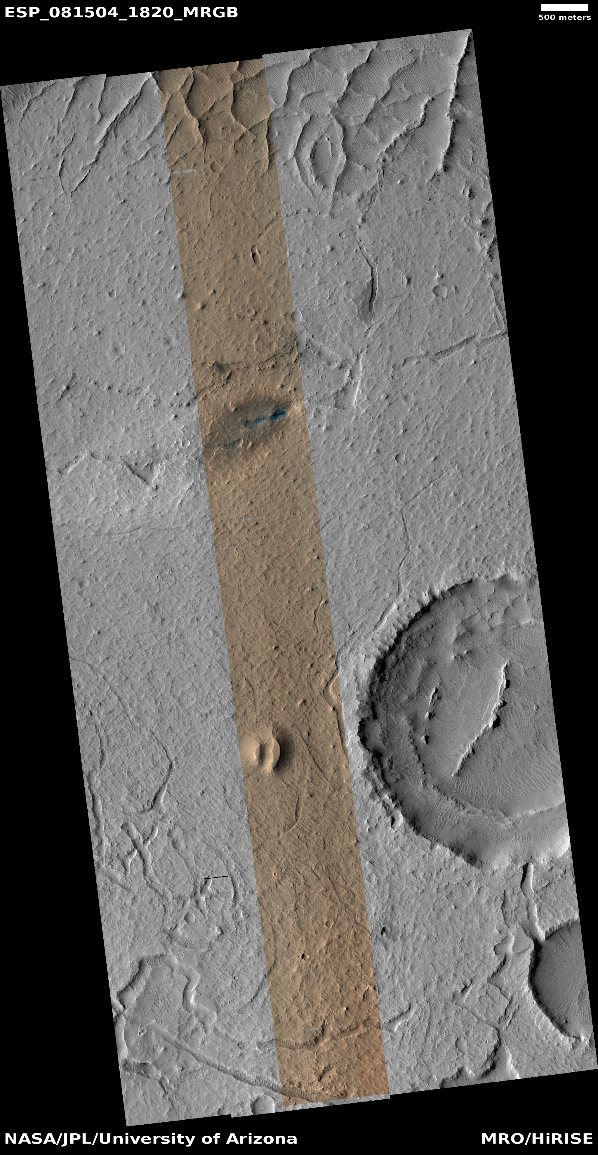
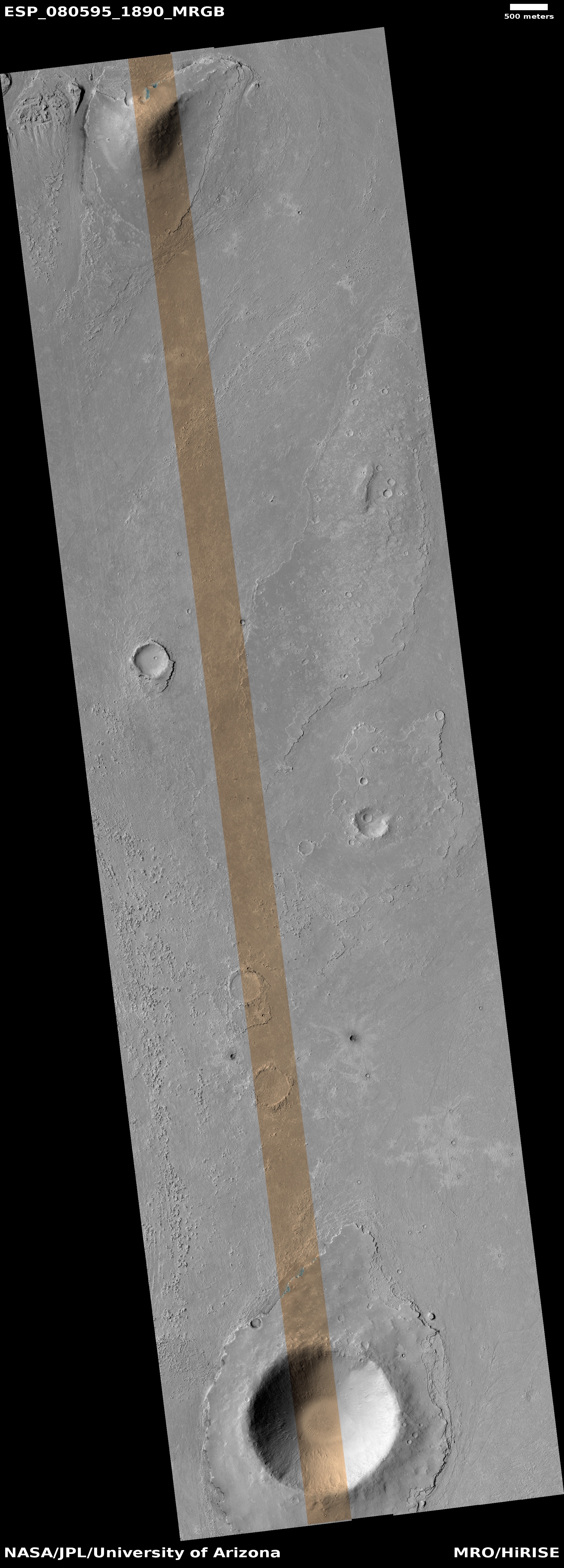
Cool image time! The picture to the right, rotated, cropped, reduced, and sharpened to post here, was taken on October 6, 2023 by the high resolution camera on Mars Reconnaissance Orbiter (MRO), and shows a spot on Mars where lava was squeezed between and around some small peaks as it flowed quickly south, flooding all the low areas in this landscape.

The science team describes the features in the full image as “streamlined”, a description that is literally accurate. As this “stream” of lava rushed past, it “lined” the higher terrain, carving it into tear-dropped shapes.

In the color strip, note the blueish spots at the northern base of the 400-foot-high hill. According to the science team’s explanation [pdf] of the colors in MRO images, “Frost and ice are also relatively blue, but bright, and often concentrated at the poles or on pole-facing slopes.” The picture was taken in summer, so if these bright spots are frost or ice, it suggests they are well shaded from sunlight in those north-facing alcoves. This location is only 9 degrees north of the equator, so finding any near surface ice here is highly unlikely. That frost might exist however is intriguing, to say the least.
» Read more

0 comments

Live stream of landing of Odysseus on Moon

South Pole of Moon with landing sites

UPDATE: The engineering team has decided to delay the landing attempt by one lunar orbit, pushing it back to 6:24 pm (Eastern). The live stream begins well before then, so that NASA can get in a lot of blather and propaganda, so feel safe waiting to tune in until 6 pm (Eastern).
——————-
Capitalism in space: I have embedded below the NASA live stream for the presently scheduled 5:30 pm (Eastern) landing on the Moon of Intuitive Machines Nova-C lunar lander dubbed Odysseus.

The green dot on the map to the right marks the planned landing site, about 190 miles from the Moon’s south pole. This will be the closest attempted landing so far to that pole, and if successful it will land on the rim of a crater, Malapart A, that is believed to have a permanently shadowed interior.

Odysseus however has no instruments capable of seeing into that interior. Its main mission is engineering, to test the landing technology of Intuitive Machines’ spacecraft. As part of this effort, it will release a small camera probe, dubbed EagleCam, when it is about 100 feet above the surface, which will to take images of that landing. [Update: That probe is unprecedented for another reason: It will be first student-built probe to land on another world, as it was designed and built by a team of students at Embry-Riddle Aeronautical University in Florida.]

If the landing is successful, Odysseus is designed to last until sunset on the Moon, about another two weeks. It carries a variety of NASA and commercial payloads, including a private small optical telescope. More important, it will allow the company to follow through with its manifest of future missions, including a second lunar landing later this year.
» Read more

14 comments

Why the public continues to lose faith with the medical community

Sudden collapse
One of many sudden public collapses.
Click for full video.

An op-ed today in the New York Post tried to explain why the medical and health community lost the confidence of so much of the public after the COVID epidemic. According to Marc Siegal, a doctor and news pundit (or as described in his bio line at the end of the essay, “a clinical professor of medicine and medical director of Doctor Radio at NYU Langone Health and a Fox News medical analyst”), the distrust was caused by the effort of the Biden administration to force the COVID jab on everyone through mandates while squelching any dissent or discussions of potential risks.

To Siegal, this effort to make believe the jab carried no risks at all was seen from the start as a lie, and has since been proven so. Better to have been honest from the start, Siegal says, so that patients could make up their own minds with all the facts in hand.

The way Siegal couches his language in his op-ed, however, only increases this distrust.
» Read more

14 comments

Curiosity’s view of Gale Crater from its new heights on Mount Sharp

Low resolution version of panorama
Click for full resolution version of panorama. For the original images, go here, here, and here.

Overview map

Cool image time! The panorama above was created from three pictures taken on Februay 13, 2024 by the left navigation camera on the Mars rover Curiosity (available here, here, and here). It looks to the north, across Gale Crater and its nearest rim, about twenty miles away. The red dotted line indicates the approximate route Curiosity took to get to this point. The yellow lines on the overview map to the right show the approximate area covered by the panorama.

The images were part of the routine mosaics created by both the left and right navigation cameras for helping engineers plot the rover’s future travels. The pictures that look back at the far rim however also provide important atmospheric data. In this case, the haze tells the scientists how much dust is in the atmosphere. It is presently winter in Gale Crater, which also corresponds to the dust storm season. Thus, the view is very hazy.

Curiosity will likely remain at this location for several more weeks, as the science team is about to begin another drilling campaign. Note the large dark area on the cliff face on the right that is also level with the terrace where Curiosity presently sits. The scientists want to get core data of this layer, and they think they are at a good spot to do so.

1 comment

Tomorrow’s landing of Intuitive Machine’s Odysseus lunar lander

South Pole of Moon with landing sites
Nova-C is Odysseus’s landing spot

NASA has now announced its planned live stream coverage of tomorrow’s landing attempt of Intuitive Machine’s Odysseus lunar lander near the south pole of the Moon.

Intuitive Machines is targeting no earlier than 5:49 p.m. EST Thursday, Feb. 22, to land their Odysseus lunar lander near Malapert A in the South Pole region of the Moon.

Live landing coverage will air on NASA+, NASA Television, the NASA app, and the agency’s website. NASA TV can be streamed on a variety of platforms, including social media. Coverage will include live streaming and blog updates beginning 4:15 p.m., as the landing milestones occur. Upon successful landing, Intuitive Machines and NASA will host a news conference to discuss the mission and science opportunities that lie ahead as the company begins lunar surface operations.

No live stream is of course active yet. When it goes live tomorrow afternoon I will embed the youtube broadcast here on Behind the Black.

If successful, Odysseus will be the first American landing on the Moon since the manned Apollo missions more than a half century ago. It will also mark the first successful lunar landing achieved by a privately-built spacecraft. Companies from Israel, Japan, and the U.S. have already tried and failed.

1 comment

Martian gullies caused by glacial and water erosion

A gully on the north rim of Niquero Crater
Click for original image.

Cool image time! The picture to the right, rotated, cropped, reduced, and sharpened to post here, was taken on December 23, 2023 by the high resolution camera on Mars Reconnaissance Orbiter (MRO).

The image shows us the north interior rim of 7-mile-wide Niquero Crater on Mars. From the high to the low points the elevation difference is about 2,500 feet, with a steep downhill slope averaging about 18 degrees. The terrain appears to show several avalanche collapses that pushed lower material out of the way, though at the bottom where that material has been pushed aside there is no obvious large debris pile.

The science team labels this image simply “volatiles and gullies”, a label that carries a host of significant information. These gullies, which were among the earliest found by Mars Global Surveyor in the late 1990s, were the first evidence that the surface of Mars had a lot of near surface ice. It is for this reason that this relatively small crater on Mars has a name. Most craters this small remain unnamed, but the gullies on Niquero’s north slopes required more study, and thus the crater was given a name.

Subsequent orbital imagery has now shown that craters like Niquero, located in latitudes higher than 30 degrees, quite often are filled with glacial debris. In fact, the material that these avalanches pushed aside at the base of the slope is that glacial material, protected by a thin layer of dust and debris. The avalanche essentially disturbed that protected layer, and thus the debris pile (made up mostly of ice) sublimated away when warmed by sunlight. Thus. no big debris pile.

The gullies tend to be on the pole-facing slopes. Scientists believe they are the remnant evidence of ancient glaciers that grew on these slopes because they were protected from sunlight. In subsequent eons, when the climate on Mars changed, those glaciers collapsed, leaving behind the gullies we see now.
» Read more

0 comments

India proposes to send its own helicopter to Mars

India has now considering adding its own helicopter to its next Mars mission, dubbed the Martian Boundary Layer Explorer (Marble).

While ISRO’s rotorcraft is still in the conceptual stage, the agency envisions a drone that can fly as high as 100 meters in the thin Martian air. Along with the Marble instrument suite, the drone is expected to carry various sensors, including temperature, humidity, pressure, wind speed, electric field, trace species, and dust sensors.

Whether this mission will include a lander, rover, or orbiter as well is very unclear, which suggests strongly the entire mission profile is presently very much undecided as yet.

2 comments

Alternating dark and light terraces inside Valles Marineris

Overview map

Alternating dark and light layered terraces in Valles Marineris
Click for original image.

Cool image time! The picture to the right, cropped and enhanced to post here, was taken on October 9, 2023 by the high resolution camera on Mars Reconnaissance Orbiter (MRO), and shows what appear to be the somewhat typical terrain at this location, in a part of the giant Martian canyon Valles Marineris dubbed West Candor Chasma. For example, I featured similar swirls in August 2022 at a place only about six miles to the east, that spot indicated by the green dot on the overview map above. The white dot marks the location of today’s image.

So, what are we looking at? The elevation drop from the high and low points is only about 180 feet, but in that short distance it appears there are more than two dozen visible layers, and those layers form terraces that alternate between bright and dark material.

The shape of the swirls also suggest that a flow of some kind, either water, ice, or wind, moved from the northwest to the southeast, carving these terraces as it descended the stair steps downward. It is also just as likely that we are seeing repeated lava flows going downhill to the southeast, each even laying another layer on top of the preceeding one. And it is also possible that we are looking at a combination of both.

The alternating dark and light layers suggest that each dark layer was an event that put down dark material, such as volcanic dust, that was subsequently covered with light material, with this process repeating itself many times over the eons.

That the floor of this part of Valles Marineris is uniquely covered in this manner is in itself intriguing. Why here, and not elsewhere within the canyon?

1 comment

The alien surface of Mars

The alien surface of Gediz Vallis
Click for original image.

Overview map
Click for interactive map.

Cool image time! The picture above, brightened slightly to post here, was taken on February 15, 2024 by the right navigation camera on the Mars rover Curiosity. It looks east at the looming cliff face of the mountain Kukenan that the rover has been traveling beside for the last six months. On the overview map to the right the yellow lines indicate roughly the area covered by this picture. The blue dot marks Curiosity’s present position, while the green dot marks its position on February 5, 2024. As you can see, the rover is making slow but steady progress uphill into Gediz Vallis.

This image illustrates the alien landscape of Mars quite beautifully. First, there is absolutely no life in this picture. On Earth you would be hard pressed to find any spot on the surface that doesn’t have at least some plant life.

Second, there is the rocky layered nature of this mountain. When the Curiosity science team first announced its future route plans (the red dotted line) to drive into this canyon back in 2019, the orbital images of these layers from Mars Reconnaissance Orbiter (MRO) had suggested the terrain here would be reminiscent of The Wave in northern Arizona, a smooth series of curved layers smoothed nicely over time by the wind.

As you can see, there is no smoothness here. Instead, every single layer here is infused with broken rock, suggesting that each layer is structurally weak. As erosion exposes each, the layer breaks up, crumbling into the chaos in this picture. The curved nature of the terrain at the bottom of the picture however does suggest that some sort of flow once percolated down this canyon, either liquid water or glacial ice, carving the layers into this curved floor.

3 comments

China targets May 2024 for launch of its Chang’e-6 lunar sample return mission

The Moon's far side
The Moon’s far side. Click for interactive map.

China is now working to a May 2024 launch of its Chang’e-6 lunar sample return mission to bring back about four pounds of material from the far side of the Moon.

The map to the right, created from a global mosaic of Lunar Reconnaissance Orbiter (LRO) imagery, shows the planned location of Chang’e-6’s landing site, in Apollo Basin. The landing site of China’s previous mission to the Moon’s far side, Chang’e-4 and its rover Yutu, is also shown. Both are still operating there, since landing five years ago on January 2, 2019.

Chang’e-6’s mission will be similar to China’s previous lunar sample mission, Chang’e-5, which included a lander, ascender, orbiter, and returner. It launched in November 23, 2020, landed a week later, and within two days grabbed its samples and its ascender lifted off. The samples were back on Earth by December 16, 2020.

There are indications however that Chang’e-6 might spend more time on the surface before its ascender lifts off with samples.

0 comments

The shoreline of a Martian lava sea

The shoreline of a Martian lava sea
Click for original image.

Cool image time! The picture to the right, cropped, reduced, and enhanced to post here, was taken on October 2, 2023 by the high resolution camera on Mars Reconnaissance Orbiter (MRO).

The science team labeled this a “lava margin.” The darker material on the right is apparently a newer deposit of lava, flowing on top of the lighter lava on the left. The newer deposit is only about three feet thick, so it had to have flowed fast almost like water to cover this large area with such a thin layer before freezing. Even so, this new lava layer has a roughness greater than the older layer below it. Either the older layer is smoother because of erosion from wind over eons, or the lava in these two layers was comprised of slightly different materials that froze with different textures.

The small ridges appear to be wrinkle ridges, created when material shrinks as it freezes.

This margin marks the edge of a very large flood lava event, as illustrated by the overview map below.
» Read more

0 comments

SpaceX successfully launches Intuitive Machines Odysseus lunar lander

South Pole of Moon with landing sites

SpaceX has successfully launched Intuitive Machines commercial Nova-C-class Odysseus lunar lander, its Falcon 9 rocket lifting off from Cape Canaveral at 1:05 am (Eastern) on February 15th.

This was the third launch in less than eleven hours today, and the second launch by SpaceX. The first stage successfully completed its 18th flight, landing back at Cape Canaveral.

The green dot on the map to the right shows the planned landing site for Odysseus, next to a crater with a permanently shadowed interior, though it will have no way to travel into it. This will also be the closest landing to the Moon’s south pole, and if all goes well, will take place eight days from today, where it will operate for about ten Earth days. You can find out more about the lander’s payloads and mission from the press kit [pdf].

It must be emphasized that like India’s Vikram lander and Pragyan rover, Japan’s SLIM lander, and Astrobotic’s Peregrine lander, Odysseus is mostly an engineering test to prove out the landing systems. If this spacecraft does any science on the lunar surface that will be a bonus.

The leaders in the 2024 launch race:

14 SpaceX
8 China
2 Iran
2 Russia

American private enterprise now leads the entire world combined 16 to 14 in successful launches, with SpaceX by itself is now tied the rest of the world combined (excluding American companies) 14 to 14.

5 comments

Spiders on the rim of a Martian crater

Spiders on the rim of a Martian crater
Click for original image.

Cool image time! The picture to the right, cropped to post here, was taken on December 29, 2023 by the high resolution camera on Mars Reconnaissance Orbiter (MRO). It shows strange spidery formations on the rim of a 17-mile-wide crater about 500 miles from the south pole of Mars.

Scientists think these spider features are formed due to the seasonal cycle on Mars. In the winter at the poles the carbon dioxide in the atmosphere falls as snow in the polar regions, creating a thin dry ice mantle that covers everything. When spring arrives, sunlight goes through the clear mantle to heat its base, causing that dry ice to sublimate into gas that is trapped below the mantle. Eventually that mantle cracks at a weak point and the gas escapes, spewing dark dust on its top. By summer the mantle is entirely gone, and the black splotches disappear as they blend back into the same colored ground.

At the south pole the ground appears to be firmer and more structurally sound than at the north pole. The trapped gas appears to travel upward along the same tributary paths to the same escape points each year, thus carving these spidery features that are permanent features.
» Read more

1 comment

Orbital perturbations caused by passing stars might very well have caused past extinctions

According to new computer simulations, scientists now think that any calculations of the long term changes in the orbits of the planets in our solar system must include the orbital perturbations caused by passing stars, perturbations that might very well have caused past extinctions. From their paper’s introduction:

Simulations of the long-term orbital evolution of the Sun’s planets have nearly always modeled the solar system as an isolated system. For many purposes, this is a very good approximation, but the solar system is of course part of the Milky Way Galaxy. Consequently, it occasionally suffers close encounters with other field stars, and solar neighborhood kinematic studies predict an average of ∼20 stellar passages within 1 [parsec] of the Sun each [million years].

Because the solar system cross section scales with the square of heliocentric distance, the large majority of these encounters will be distant and inconsequential to the planets’ dynamics, but this is not guaranteed. In fact, there is a ∼0.5% chance that a field star passage will trigger the loss of one or more planets over the next 5 [billion years], and such passages may actually guarantee the disruption of the planets’ orbits many [billion years] after the Sun becomes a white dwarf. Yet, encounters need not trigger an instability for them to have dynamical consequences for the planets. For instance, it has been suggested that ∼one-third of Neptune’s modern eccentricity has been generated through past stellar encounters, but many of the long-term dynamical effects of stellar passages remain unknown.

Their simulations as well as other data suggest that for computer models to have any chance of accurately calculating the orbital evolution of the solar system’s planets, those models must include the passing of nearby stars.

Or to put it in more blunt terms, the uncertainties here are so great that it is unlikely any computer model will ever be able to reconstruct our solar system going back further than 50 million years.

7 comments

One instrument on Perseverance has a problem

One of the instruments on the Mars rover Perseverance appears to have a problem that is preventing it from using its laser to collect spectroscopic data of the nearby Martian surface.

Data and imagery from NASA’s Perseverance Mars rover indicate one of two covers that keep dust from accumulating on the optics of the SHERLOC instrument remains partially open. In this position, the cover interferes with science data collection operations. Mounted on the rover’s robotic arm, SHERLOC uses cameras, a spectrometer, and a laser to search for organic compounds and minerals that have been altered in watery environments and may be signs of past microbial life.

The mission determined on Jan. 6 that the cover was oriented in such a position that some of its operation modes could not successfully operate. An engineering team has been investigating to determine the root cause and possible solutions. Recently, the cover partially opened. To better understand the behavior of the cover’s motor, the team has been sending commands to the instrument that alter the amount of power being fed to it.

Should this troubleshooting fail to fix the dust cover, the rover’s other instruments can still compensate, gathering spectroscopy in other ways. Losing SHERLOC however will still reduce the data that Perseverance can obtain.

0 comments

German-built mini-rover for Japanese Phobos mission shipped to Japan

A German-built mini-rover, dubbed Idefix, has now been shipped to Japan to intergrate it as a secondary payload on that country’s MMX mission to the Martian moon Phobos.

The rover itself weighs 25 kilograms (55 pounds), is 51 centimeters long (20 inches), and is designed to explore up to 100 meters of Phobos’ surface. During one of MMX’s closest approaches to Phobos, the rover will be released at an altitude between 40 and 100 meters above the surface and touch down on Phobos. The drop utilizes the low gravity of Phobos, which will allow IDEFIX to just fall onto the surface, roll, and then raise itself to prepare for the roughly three-month-long mission. The gravity of Phobos is only roughly 1/1000th of the gravity of Earth, which can be attributed to the moon’s small size. Phobos only has a diameter of approximately 27 kilometers.

“Thanks to the low gravity, IDEFIX will need between 60 to 80 seconds from release to the touchdown on Phobos. The impact will be with less than one meter per second,” explained Professor Markus Grebenstein, who is DLR’s project lead for IDEFIX, in an interview with NSF.

If all goes right, the rover’s mission will last at least 100 days. MMX itself it scheduled to reach Phobos in 2029.

Meanwhile, scientists used one of the Perseverance’s high resolution cameras to capture another partial eclipse of the Sun by Phobos. This is not the first such Phobos eclipse that Perseverance has photographed (see for example here and here), but it is neat nonetheless.

0 comments

Water found on two main-belt asteroids?

Using data from the now-retired SOFIA airplane telescope, scientists think they have detected evidence of water molecules on Iris and Massalia, two well-known asteroids in the main asteroid belt.

“We detected a feature that is unambiguously attributed to molecular water on the asteroids Iris and Massalia,” Arredondo said. “We based our research on the success of the team that found molecular water on the sunlit surface of the Moon. We thought we could use SOFIA to find this spectral signature on other bodies.”

SOFIA detected water molecules in one of the largest craters in the Moon’s southern hemisphere. Previous observations of both the Moon and asteroids had detected some form of hydrogen but could not distinguish between water and its close chemical relative, hydroxyl. Scientists detected roughly equivalent to a 12-ounce bottle of water trapped in a cubic meter of soil spread across the lunar surface, chemically bound in minerals.

“Based on the band strength of the spectral features, the abundance of water on the asteroid is consistent with that of the sunlit Moon,” Arredondo said. “Similarly, on asteroids, water can also be bound to minerals as well as adsorbed to silicate and trapped or dissolved in silicate impact glass.”

You can read their paper here.

There remains uncertainty with this result, but there is also no reason for water not to be found on these main belt asteroids. They are far enough away from the Sun so that conditions are likely cold enough for that water to remain frozen or locked in the ground.

1 comment

Martian dunes with strange splotches

Martian dunes with splotches

Cool image time! The picture to the right, cropped to post here, was taken on December 20, 2023 by the high resolution camera on Mars Reconnaissance Orbiter (MRO). It shows what the science team labels as “Dunes with Blotches.”

The blotches, or as I call them splotches, are the round dark patches on dunes themselves. Though their darkness is reminiscent of the dark patches that appear as spider features in the south polar regions of Mars, there are problems linking the two. The spiders form when the winter mantle of dry ice that falls as snow begins to weaken when the Sun reappears in the spring. Sunlight travels through the clear dry ice to warm the base of the mantle, causing it to sublimate into carbon dioxide gas. That gas however is trapped at the base, and only escapes when the thin mantle cracks at weak points. As the gas puffs out it carries with it dust, which leaves dark patches on the surface that disappear when the mantle disappears entirely by summer.

In the southern hemisphere at the poles the ground is somewhat stable, so the trapped gas appears to travel along the same paths each year to the same weak spots. This in turn causes it to carve spidery patterns in the ground, like river tributaries, except here the tributaries of gas flow uphill to their escape point. At the north pole the ground is not as stable. Instead we have many dunes, so that the dry ice mantle sublimates away at different places each year. There is no chance to form such spider patterns over time.

Making these splotches more puzzling is the season. This picture was taken in the winter, at a time one would think no dry ice is sublimating away.
» Read more

0 comments

The volcanic world of Io, as seen by Juno in all its fly-bys

Map of Io
Click for full resolution image.

The mosaic of images above, reduced and sharpened to post here, was compiled by citizen scientists Gerald Eichstädt, Jason Perry, and John Rogers from images taken of the Jupiter moon Io during the three close fly-bys by the orbiter Juno that occurred during its 55th, 57th, and 58th orbits. From the caption:

Global map of Io by JunoCam, combining maps from PJ55, PJ57 and PJ58. Both the sunlit side and the Jupiter-lit-dark side are included. PJ55 map by Gerald Eichstädt; PJ57 map by Jason Perry; PJ58 map by Gerald Eichstädt and John Rogers. Some scaling and shifting was performed in order to align the maps with each other and with the USGS Voyager/Galileo map. Colours were adjusted for better compatability. –John Rogers.

A labeled version, showing the names of many volcanoes but only of the areas photographed during the most recent 58th orbit fly-by on February 3, 2024, can be seen here.

As Juno’s later fly-bys will be progressively farther away, we will no longer get better views of Io until another spacecraft arrives in a Jupiter orbit capable to returning to Io, possibly decades from now. Though Europa Clipper will arrive in Jupiter orbit April 2030, that orbit is designed to repeatedly fly close past Europa, and will likely never get close to Io.

Thus, this map provides a baseline for determing any changes that occur on Io in the coming years.

0 comments
1 55 56 57 58 59 440