Wales Day 7

Cregennan

The home of 18th century composer John Williams

The tree

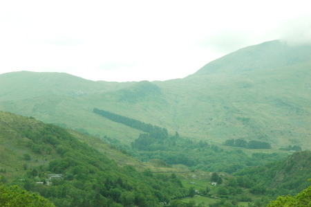
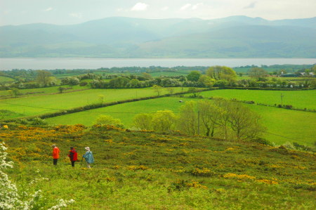
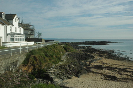
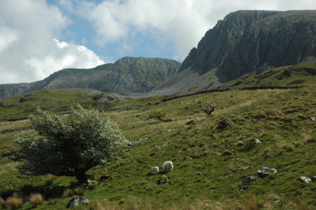
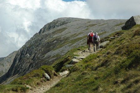
In our final day of our Wales journey, we spent the day strolling across the beautiful countryside of Cregennan, one of several parks along the flanks of the Cadair Idris range, which runs north-south to the coast. This park is closest to the ocean, so at our highest point we were overlooking the Irish Sea and the town of Barmouth.

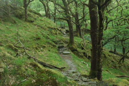
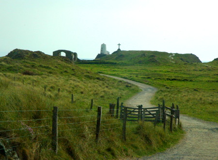
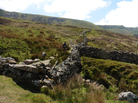
The three pictures on the right are only a small selection of the beauty of this region. There were several magnificent lakes nestled amid the mountains and fields. There were pastures with numerous sheep, some eating, some resting like white blobs on the green grass, and some “baa’ing” at each other. It was especially entertaining when a lamb started calling out for its mother, the mother responding, and then the two searching and finding each other.

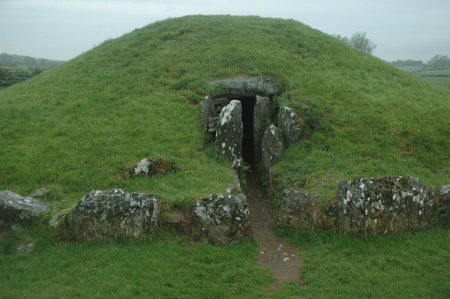
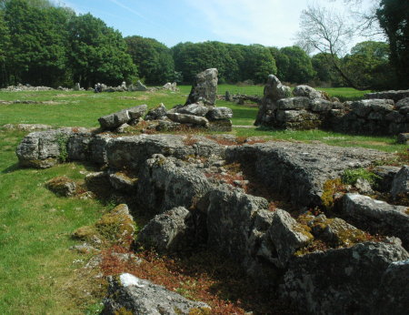
And of course there were the standing stones and ancient ruins scattered about on several hilltops.

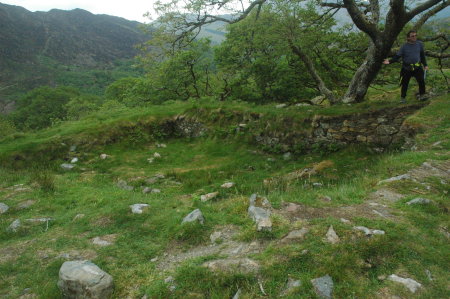
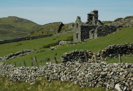
The abandoned house in the second picture is of special interest because it had been the home of an obscure 18th century Welsh composer by the name of John Williams. Williams was actually quite successful in his time, but only recently have some locals rediscovered unpublished manuscripts of his work. They plan a performance this fall.

Apparently his father was a hat-maker of some note, able to accumulate enough wealth to build this large country house in such a setting. Though I don’t know this, I suspect his success came from providing high quality hats to the upper classes, and this in turn gave his son the contacts necessary to become even more successful as a composer.

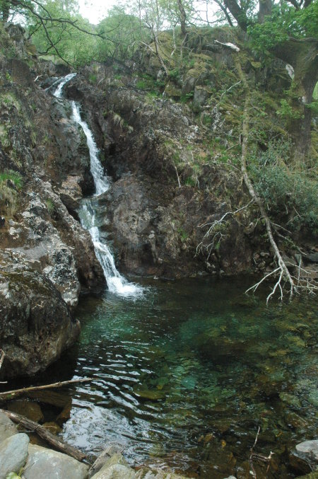
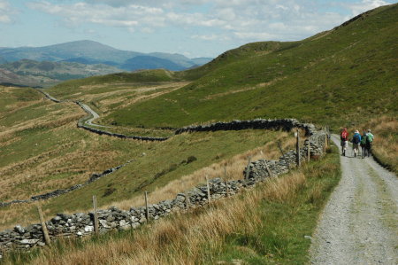
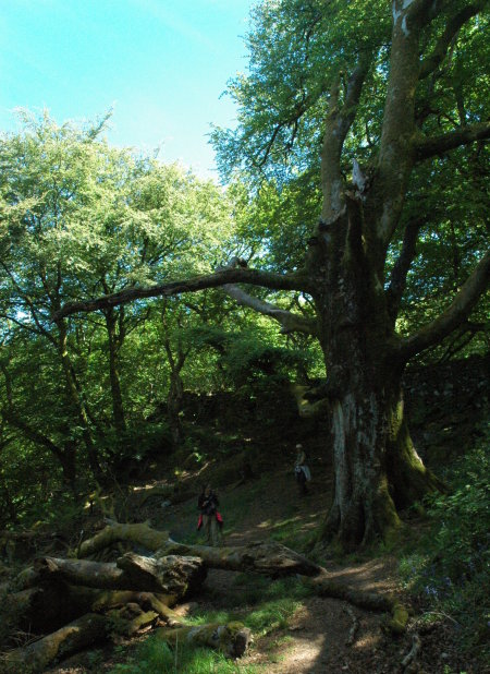
The last photo was taken as we walked downhill toward the ocean in a forested area beside a flowing stream, passing numerous waterfalls. This area is where our tour leader, Hywel “Taff” Roberts, was born and grew up, so he could give us some extra historical details about everything we saw. For example, the giant tree in that last picture was something that he remembered since childhood, home for birds and animals galore. It is old now, which is why several large branches have broken off.

Tomorrow the tour ends, and Diane and I will be taking the train to London, where we will spend two days before flying back to the states.
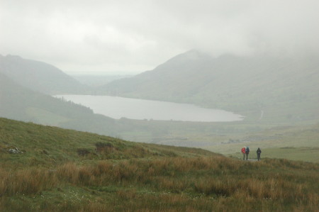
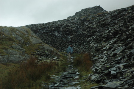
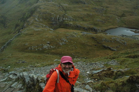
Wales Day 6

Sheep on the flanks of Cader Idrisc

Stone walls on the flanks of Cader Idris

Approaching the halfway point in the hike up Cader Idrisc

After yesterday’s long hike on Mount Snowdon, today was planned as an easier day. First we changed locations, driving south to the village of Dolgellau.

In the morning we heard two short presentations, first about the first discovery of Wales by tourists in the 1700s, and second a more scholarly look at the place names of Wales that appear connected to Arthur. In this case the speaker, Scott Lloyd of the Royal Commission on Ancient and Historical Monuments of Wales, was focused more on what is really known, and was thus less sure about Arthur’s links to Wales than our previous expert, Gareth Roberts. Lloyd has documented the many place names (see his book, The Arthurian Place Names of Wales), but he has also documented the important detail that most started appearing after the first writings about Arthur started to appear, with most appearing several centuries after Arthur supposedly lived. This suggests that the names were chosen because of the legend, not because the man had been there.

In the afternoon some of us did a short hike halfway up the nearby mountain Cader Idris. The first picture shows the mountain at the top right, with sheep in the center, and a hawthorn tree in bloom to the left. The second picture shows the trail going uphill parallel to one of the many typical stone walls found everywhere in Wales. The land is very rocky, and to make it better for grazing farmers would clear the stones from the fields, putting them in piles to the side. Then, when the enclosure laws were passed in the early 1800s they used those stones to build the walls to define their property lines.

The third picture shows Taff and Barbara ahead of me, with Cader Idris in the distance. Shortly thereafter we stopped to lie on the soft heather to chat and admire the countryside and the grey rocky slope going up to the peak ahead of us. We then headed back down for dinner and an evening in town.

Wales Day 5

Lower part of Rhyd Ddu trail

Walking through West Snowdon Quarry

Taff Roberts on the stair climb up Clogwyn Du

Our crew with the summit in view

The goal today was to hike up to the top of Mount Snowdon, the highest point in Wales, as well as the island of England. Diane and I didn’t make it, but not for want of trying.

The route we took started at the trailhead of the Rhyd Ddu trail, one of the more popular routes up the mountain. The top photo to the right shows the view from the lower elevations of this trail, and gives a good sense of the beauty, barrenness, and dampness of the day. Though it never really rained on us, the sky was almost always overcast and the cloud cover sometimes came down to engulf us.

Rather than take Rhyd Ddu straight north to the top, however, our route has us head right (east) up the Clogwyn Du trail through the now inactive West Snowdon slate quarry, and then turn left (north) up the nose of a very steep ridgeline to meet up with Rhyd Ddu close to the summit. The second image on the left shows Diane standing on the trail surrounded by slate tailings from that quarry.

The next picture shows Hywel “Taff” Roberts, our leader and the owner of Wild Wales Tours, with the distant mountain floor below us. We have begun the climb up the nose of that ridgeline, with the initial section up a very steep stone staircase cut into the ground. I could not help but think of the stairs of Cirith Ungol from Tolkien’s Lord of the Rings.

The last photo was taken by Taff showing our entire crew, with the peak of Mount Snowdon hidden by clouds at the top center of the image. From left to right we have Pat, Dennis, the sisters Penny and Barbara, our second guide Haf, and then Diane and myself. The peak at the top-left is actually the start of the knife-edge ridgeline that leads to the peak. Where that ridgeline begins Clogwyn Du meets up again with Rhyd Ddu, which follows that very narrow knife-edge ridge to the summit, with 1000 foot drop-offs on either side.

When we got to Rhyd Ddu on that ridgeline Diane and I decided to head back down on Rhyd Ddu. We were now in the clouds, so going on to the peak seemed silly as we likely wouldn’t be able to see anything. Moreover, it was colder than either of us are used to or like. While Taff came down with us, everyone else continued to the peak. As I write this they have not yet returned, though I have no doubt they had a spectacular time crossing that ridge to the summit. UPDATE: The rest of the crew made the peak, but could see nothing for that entire section of hike, because of the clouds.

Not making the summit does not bother me much. I like to get to the top, but also know that we could it do another time should we decide to try. Diane and I have been doing this for a lot of years. We know our capabilities. We don’t need to prove them to others or ourselves.

Besides, the views up until then had been breath-taking, and they continued to be as good on the hike down. This was why we came, and it paid us amply in beauty every step of the way.

Wales Day 4

Sygun Fawr

Today's hike

Merlin's Pool

Foundation at top of hill

Today’s adventure in Wales was a pleasant seven mile hike up onto a small hill, Dinas Emrys, nestled in the pass in Snowdonia National Park that crosses from north to south Wales past Mount Snowdon. Our hotel, Sygun Fawr, can be seen in the lower left corner in the first picture on the right, which I took from the top of this hill. If you look close, you can see the window of our second floor room, looking out at the mountains.

The hike was through some of the lushest green woods I’ve ever seen, as illustrated by the second picture on the right. The trail itself was clearly very old, with stone steps and even a simple bridge made of flat stones and laid across a stream with a single larger rock in the center for support.

The hill itself is associated with Merlin in a number of ways. For example, the pool at the base of the waterfall in the third picture has been called Merlin’s Pool for centuries. Furthermore, Merlin supposedly hid a treasure in a cave somewhere on the hill, which will only be discovered by someone with golden hair and blue eyes and who will be guided to the cave by a bell ringing.

Legend also tells this tale:

Fleeing Anglo-Saxon invaders Vortigen came to Wales and chose the hillfort as his retreat. However all efforts at building on the site failed, with workers returning daily to find collapsed masonry. Vortigern was counselled to seek the help of a young boy born of a virgin mother; a suitable boy was found named Myrddin Emrys (Merlin Ambrosius). Vortigern’s plan to kill Myrddin to appease the supernatural powers preventing him from building his fortress was scorned by Myrddin who instead explained that the fort could not stand due to a hidden pool containing two dragons. The White Dragon – he explained – of the Saxons would in time be defeated by the British Red Dragon.

The fourth pictures shows Gareth Roberts, our guide who as mentioned yesterday has been researching Welsh Arthurian place names, standing on the foundation of the ruin at Dinas Emrys’ top. To his left and slightly lower down on the hill in a gully was a second foundation and a pool from a natural spring. This spring was another reason this hilltop was a favored site for a stronghold, as it not only gave clear views both up and down the valley, was very defensible, but also had a ready supply of water. A fortress here would withstand attack for a considerable time.

Tomorrow we climb Mount Snowdon itself, The hike’s length will likely be about nine miles, and will gain 2,900 feet in elevation, somewhat comparable to many hikes in southern Arizona. The weather looks excellent, with spring temperatures at the mountain’s base.

Wales Day 3

Bryn Celli Ddu

Arthur's Table

John Jo splitting slate

Our travels today in Wales took us to three sites, all completely different.

First we visited Bryn Celli Ddu, a neolithic burial chamber, built about 5,000 years ago and shown in the top right photo. After following a well-defined path along the edge of two fields, we all entered this mound and stood in the chamber inside. The entrance shown in the image was aligned with the summer solstice so that the sun at sunrise would beam directly into the inner chamber.

Next, we drove to the northeast corner of the island of Anglesey to climb a flat-topped hill called Arthur’s Table. Our guide, Gareth Roberts, has been doing extensive research on the place names in Wales that appear to link directly to the legend of King Arthur. It is his contention (supported by those place names as well as research by others) that Arthur was actually a Welsh military leader, born of Roman parents (who had integrated into Welsh society) and who united the tribes to fight the Saxon invaders in the sixth century, after the Romans had abandoned the British Isles. He has found more than a hundred place names in this part of Wales named in honor of Arthur. He has also found in the written record much evidence linking Arthur to Wales and the war to resist the Saxons.

This particular hilltop has been identified by archeology as the location of a significant Welsh village from the time the Romans were conquering Great Britain. The middle right photo, taken from the top, looks east across the Menai Strait that separates Anglesey from the mainland, with the mountains of Snowdonia beyond. This strait is where the Romans crossed in their first attempt to conquer Anglesey and Wales.

Roberts’ thinks that the Round Table from the King Arthur legends was a misinterpretation by later French and British storytellers of this important Welsh hilltop village. Instead of being a table where Arthur ruled with his knights, the table was this hilltop, where that Roman invasion was first spotted during their initial invasion. Five hundred years later, when the Saxons invaded and Arthur led the resistance to them, Roberts’ believes the name was given because in some way Arthur was connected to it.

The third image shows slate cutter John Jo as he demonstrates how to split slate into the thin slate tiles that are used to cover rooftops. We watched this demonstration as part of a full tour of the National Slate Museum, nestled within the mountains on the way to Snowdonia, where for more than hundred years one of the world’s biggest slate mines mined, processed, and sold slate. Closed since 1969, the mine facility now serves as a museum. The most spectacular feature of this mine facility was the still functioning giant water wheel, more than fifty feet in diameter, that was turned by a stream of gravity-fed water at its base and was used to run all the belts that powered all the belt-driven machinery in the facility. The video of the wheel, embedded below the fold, shows the wheel as we saw it today. Unfortunately it does not include any people in it for scale, though one of the last shots shows a ladder for accessing the wheel’s top. Trust me, a person seems dwarfed by this wheel.

We then drove up over the mountain pass in Snowdonia National Park to our hotel, nestled at the base of Mount Snowdon. We shall be spending the rest of our trip hiking these mountains. The hike tomorrow will once again be led by Gareth Roberts and will show us further links between Arthur and Wales. On Sunday we will attempt to hike to the top of Mount Snowdon.
» Read more

Wales Day 2

South Stack

Din Lligwy

Ynys Llanddwyn

Our journey through Wales continues. Today, as with yesterday, we explored the island Anglesey, which forms the northwest corner of Wales.

The day began going to Anglesey’s northwest coast to hike north to the South Stack lighthouse, as shown in the top right image. At this resolution you cannot see them, but the greyish-green rock faces rising one third to halfway up these cliff faces are covered with thousands and thousands of birds, including the guillemots, razorbills, chough, and puffins. Among them also stalks the herring gull, which is hoping to pick off an easy meal by grabbing the young offspring of the other birds.

We walked about two miles along these high dramatic cliffs to the lighthouse, which unfortunately was closed today because it had been reserved for an elementary school class trip.

We then drove to the little visited ruins of Din Lligwy (don’t ask me to explain how to pronounce it), shown in the second image to the right. These ruins are hidden behind trees on a high hill overlooking the part of the Irish Sea north of Wales and are what is left of a Welsh/Roman village. The ruins include the circular stone structures used as foundations for Welsh homes as well as the square stone wall/foundations used by the Romans. It is thus thought that after the Romans conquered Wales and before their abandonment of the British Isles the Romans intermarried with the Welsh and added their architectural designs to that used by the Welsh. The image shows the largest square foundation, with the two standing stones delineating the building’s entrance. To the left, out of frame, is a Welsh circular structure that to my eye looked exactly like a kiva that one sees in all the American Indian ruins of the southwest.

After visiting a number of other ruins, we then headed to the island’s southernmost point, to the peninsula of Ynys Llanddwyn, also called Dwynwen’s Island. It is no longer an island, because in the 1400s a giant storm, followed by several more, dumped a gigantic amount of sand along the shore, thus extending that shoreline several miles seaward and connecting the island to the mainland.

The bottom picture shows the peninsula’s distance lighthouse, and the ruins of a church (the arch) built to honor Dwynwen, who had been a Welsh princess. According to legend, she had been betrothed but fell in love with another man, who when he found out about the betrothal attacked her. This broke her heart, and she ended up running away to live unmarried on this island for the rest of her life, dedicated to helping unhappy lovers. For this she was made the patron saint for lovers by the Catholic Church.

To visit all these sites required us to cross Anglesey practically from the top to the bottom, generally traveling secondary roads. The land was a gentle rolling terrain, covered with numerous small farms whose amazingly lush and well-kept fields were devoted almost entirely to grazing sheep and cattle. The villages were all small, whose packed trim homes were either built during the 1800s or built to fit that style. Overall I got the impression that though this part of Wales might not be wealthy, its people had a strong sense of civic pride.

Tomorrow we head to Mount Snowden and the mountains. The scenery should get a bit more dramatic.

In Wales

747

The view from the Village of Rhosneigr

This will be a short post, as we are about to leave on our second day’s adventures.

To the right is the plane that finally got us out of the U.S. to London, where we had to transfer again to get to Dublin. Twas nice to fly on a 747, rapidly disappearing from the fleets of American airline companies. British Airways however appears to still be flying a lot of them. A super smooth flight on this magnificent plane.

Transferring planes in Heathrow was horrible, as it seems all international travel is becoming. Even though we were never leaving the terminal they still forced us to go through customs.

The second picture shows the view from the coastal village of Rhosneigr at the end of the day. We had met up with our group and had just completed a 4 mile hike along the beach. It seems there are a lot of bird watchers among us. It also seems in a way like we were back at Cannon Beach, without any crowds at all.

Time to go! More later.

Off to Wales for two weeks

Today Diane and I are off for a two week vacation hiking and sightseeing in Wales, beginning with a day in Dublin and finishing with two days in London. During that time I will continue to post, but expect my posts to show up at very odd hours, as I settle into the British time zone, five hours ahead of New York.

Along the way I should also post, as I usually do, some commentary and pictures about our trip and my impressions of this insistently different part of Great Britain. The description of the tour itself can be found here.

For me this trip will be a very different experience, in that in all my other travels I always made all the arrangements, in order to save money. This time we decided to splurge and let someone else do that work. Should be fun, and most interesting.