NASA document: Starship orbital flight in March ’22
Click for full image.
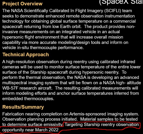
According to a NASA proposal to observe and measure the temperatures on Starship’s thermal protection during its return to Earth from orbit, that flight is now tentatively scheduled for March ’22.
The graphic to the right highlights the pertinent language in the poster presentation.
It must be noted that the poster might not be telling us when Starship will first launch, but when the designers of the camera system will be ready to film. The two are different. Still, the slowdown in flight testing at Boca Chica by SpaceX since July suggests there may be some truth to this date. That date also seems more reasonable now in connection with the FAA’s regulatory pace, which still needs to provide the final approval of SpaceX’s environmental reassessment of its Boca Chica launch site.
It also seems to me that the March ’22 date would be very convenient for NASA, as it almost certainly guarantees that Starship will reach orbit after SLS, thus avoiding for the agency a very big public relations embarrassment. I would not be surprised at all if the Biden administration and NASA’s top administrators, led by Bill Nelson, are purposely pressuring the FAA to make sure that Starship orbital flight is delayed until after the first SLS test flight, now expected in the January/February time frame.
There is also the possibility that SpaceX’s targeted launch dates were unrealistically optimistic. The company had a lot of work it needed to do prior to launch on its orbital launch facility at Boca Chica, and that work could not go forward while test flights and static fire tests were taking place. Pausing those tests has allowed the launch facility work to move forward aggressively.
Click for full image.
According to a NASA proposal to observe and measure the temperatures on Starship’s thermal protection during its return to Earth from orbit, that flight is now tentatively scheduled for March ’22.
The graphic to the right highlights the pertinent language in the poster presentation.
It must be noted that the poster might not be telling us when Starship will first launch, but when the designers of the camera system will be ready to film. The two are different. Still, the slowdown in flight testing at Boca Chica by SpaceX since July suggests there may be some truth to this date. That date also seems more reasonable now in connection with the FAA’s regulatory pace, which still needs to provide the final approval of SpaceX’s environmental reassessment of its Boca Chica launch site.
It also seems to me that the March ’22 date would be very convenient for NASA, as it almost certainly guarantees that Starship will reach orbit after SLS, thus avoiding for the agency a very big public relations embarrassment. I would not be surprised at all if the Biden administration and NASA’s top administrators, led by Bill Nelson, are purposely pressuring the FAA to make sure that Starship orbital flight is delayed until after the first SLS test flight, now expected in the January/February time frame.
There is also the possibility that SpaceX’s targeted launch dates were unrealistically optimistic. The company had a lot of work it needed to do prior to launch on its orbital launch facility at Boca Chica, and that work could not go forward while test flights and static fire tests were taking place. Pausing those tests has allowed the launch facility work to move forward aggressively.