Ingenuity completes 43rd flight on Mars, the longest in almost a year
Overview map
Click for interactive map.

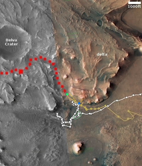
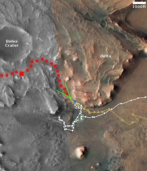
The Mars helicopter Ingenuity today successfully completed its 43rd flight on Mars, traveling 1,280 feet for 2 minutes and 26 seconds.

The green dot on the map to the right marks Ingenuity’s position before the flight, with the green lines marking the approximate direction and distance flown. The Perseverance/Ingenuity team has not yet updated its interactive map, so the precise landing spot is not yet available.

This flight was the helicopter’s longest since April 2021, just before the onset of the long six-month-long Martian winter. At that time Ingenuity completed its 28th flight, traveling 1,371 feet. Since then engineers struggled to keep Ingenuity alive during the dark winter, a task made more difficult due to an unexpected higher winter dust storm season.

Winter however is over, the helicopter is now fully charging with no problem, and has new flight software that allows it to go higher and over rougher terrain. In fact, like the last flight, Ingenuity flew farther and longer than planned, as it had been programmed to go 1,235 feet for 2 minutes and 17 seconds. That extra 45 feet and 9 seconds were likely used by the helicopter to locate a safe landing spot.

For perspective, Ingenuity’s total mission was originally planned to last only 30 days, and complete about a half dozen test flights merely to prove the concept of flight on Mars was possible. It has now lasted two years, completed 43 flights, and traveled almost five and a half miles. An amazing engineering achievement by JPL’s engineering team.
4 comments

The endless volcanic ash of Mars’ Medusae Fossae Formation

The endless volcanic ash of Mars' Medusae Fossae Formation
Click for original image.

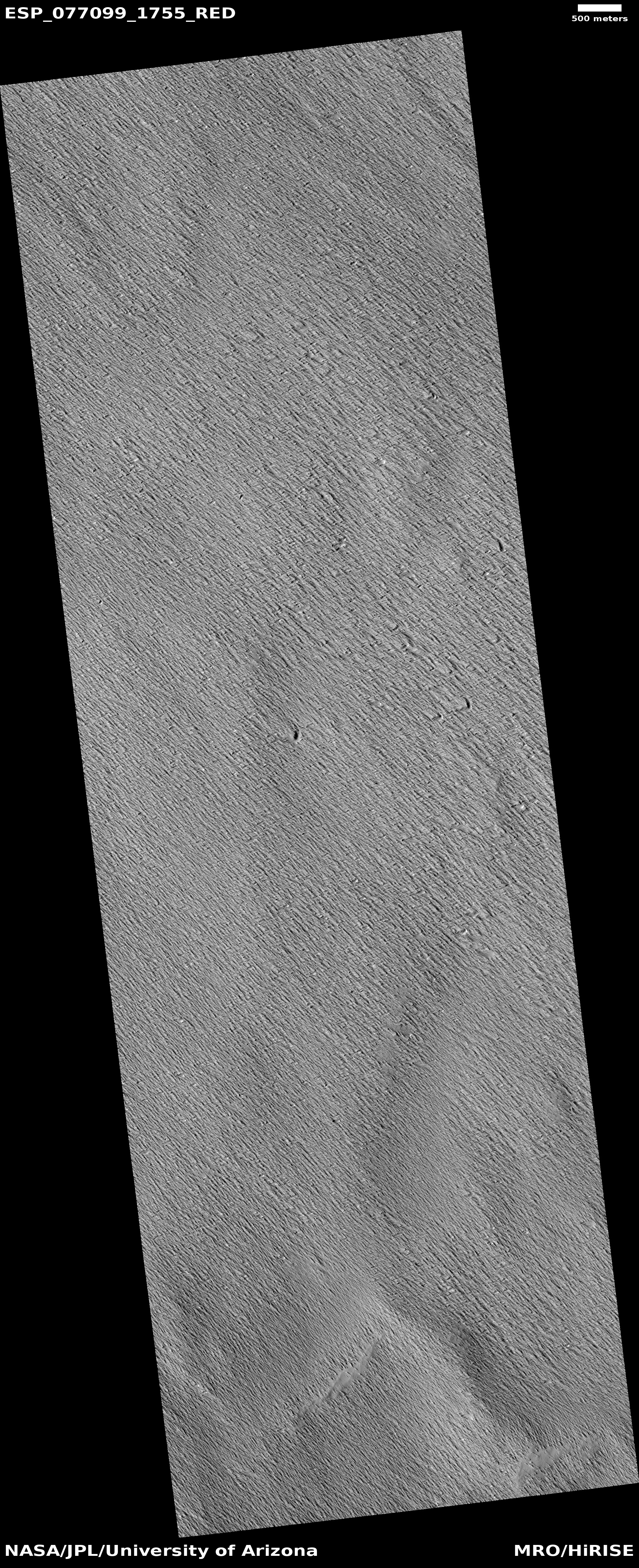
Cool image time! The picture to the right, cropped, reduced, and enhanced to post here, was taken on January 6, 2023 by the high resolution camera on Mars Reconnaissance Orbiter (MRO), and shows a small but typical area of the Medusae Fossae Formation, what is thought to be the largest volcanic ash deposit on Mars.

The picture itself was a “terrain sample,” taken by the MRO science team not as part of any specific research but to fill a gap in the camera’s schedule so as to maintain its temperature. The terrain itself looks like a field of sand that someone had run a fine comb across. In this case, the comb was the winds of Mars, prevailing from the southeast to the northwest. The crescent-like divots in the picture’s lower right are probably caused by some hard underground feature that the winds cannot blow away. Instead, it blows around, like water in rapids flowing around a rock, and takes the ash with it as it does so.
» Read more

1 comment

“What the heck?!” swirls on Mars


Click for original image.

Time for another “What the heck?!” image on Mars. The picture to the right, cropped to post here, was taken on January 6, 2023 by the high resolution camera on Mars Reconnaissance Orbiter (MRO). It is what the science team calls a “terrain sample,” which means it wasn’t taken as part of any specific scientific investigation and requested by a scientist. Instead, it was taken to fill a gap in MRO’s schedule. In order to maintain the camera’s proper temperature it is necessary for it to take regular pictures, and sometimes if there is a gap between requested images the science team picks something almost at random to fill the gap.

Sometimes the picture results in something relatively uninteresting. More often they try to pick something intriguing but not yet of interest to any particular researcher. With today’s cool image they certainly found something intriguing, so much so that I haven’t the faintest idea what is going on here.

Clearly, the tan swirls lie on the higher topology, and could be dust covered. The darker hollows in between could be darker because they are so, or because they are in shadow.
» Read more

0 comments

A glacial river on Mars

A glacial river on Mars
Click for full image.

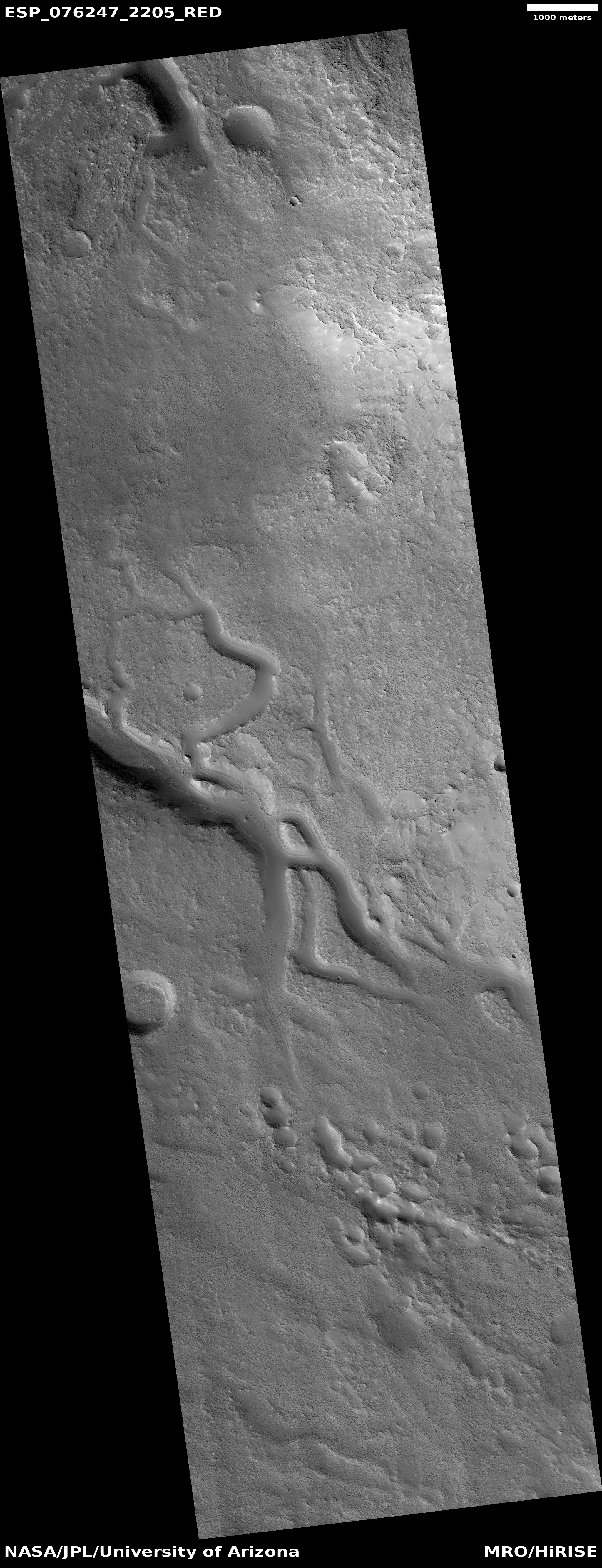
Cool image time! The picture to the right, cropped, reduced, and sharpened to post here, was taken on November 1, 2022 by the high resolution camera on Mars Reconnaissance Orbiter (MRO). It shows a wonderful example of a glacier-filled canyon on Mars, the ice apparently flowing both along and around mesas as it carves its way downhill.

I think the downhill grade here is to the north, but this could be wrong for the two side canyons on the main canyon’s north side.

Not only is the material in the canyon likely ice, covered with a protective layer of trapped dust and ash that makes the glacier surface look so smooth, the mesa tops are likely impregnated with ice as well. The mesas however have little dust, so the plateaus have a mottled stippled look likely caused by sublimation of that underground ice.

The location of these canyons explains the presence of ice.
» Read more

0 comments

Winter finally ends for Ingenuity

According to a detailed update today by Travis Brown, Chief Engineer of the Mars helicopter Ingenuity, the helicopter has now finally exited its difficult winter conditions that began in May 2022 and only ended at the end of January 2023.

One month to the day after the Dec. 24 flight attempt, Ingenuity did something it hadn’t done during the previous 260 sols – it slept “warmly” through the entire night. Data leading up to this event had suggested that such a survival was possible, but 8 long months of winter had tempered the team’s optimism. When Ingenuity’s team reviewed the downlinked data, they found that not only had it started living through the night, but had actually begun to bank power in its batteries. We’ve now seen end-of-sol states of charge in our batteries of more than 90% — an unbelievable number just days earlier. All the above means our sleepy friend has finally awoken from its long winter malaise, just in time to race up the Jezero Crater Delta and provide valuable advanced imaging for Perseverance.

Brown describes in detail their struggle for the past eight months to keep Ingenuity alive. That information is going to be crucial in designing future Mars helicopters, including the ones that will return to Jezero Crater sometime in the next decade to grab the core samples Perseverance has deposited for pick up and return to Earth.

1 comment

Cracked ash-filled Martian terrain

Cracked ash-filled fissures on Mars
Click for original image.

Cool image time! The photo to the right, cropped, reduced, and sharpened to post here, was taken on September 26, 2022 by the high resolution camera on Mars Reconnaissance Orbiter (MRO). The science team labeled this “Possible Pit,” but other than a small dark stain on the rim of a crater north of the section cropped to the right, I could find nothing that even closely resembled a pit. More likely the scientists were referring to the large circular depression in the top center of this picture. It does not at first glance look like a crater, as it has no obvious rim. In fact, almost none of the circular depressions in this image look like craters, as almost none have uplifted rims.

However, it is not clear what caused these dust-filled fractures as well as the image’s many circular depressions. The location, as indicated by the overview map below, does not really help.
» Read more

1 comment

Terraced serrated layered mesas on Mars

Terraced mesas on Mars
Click for original image.

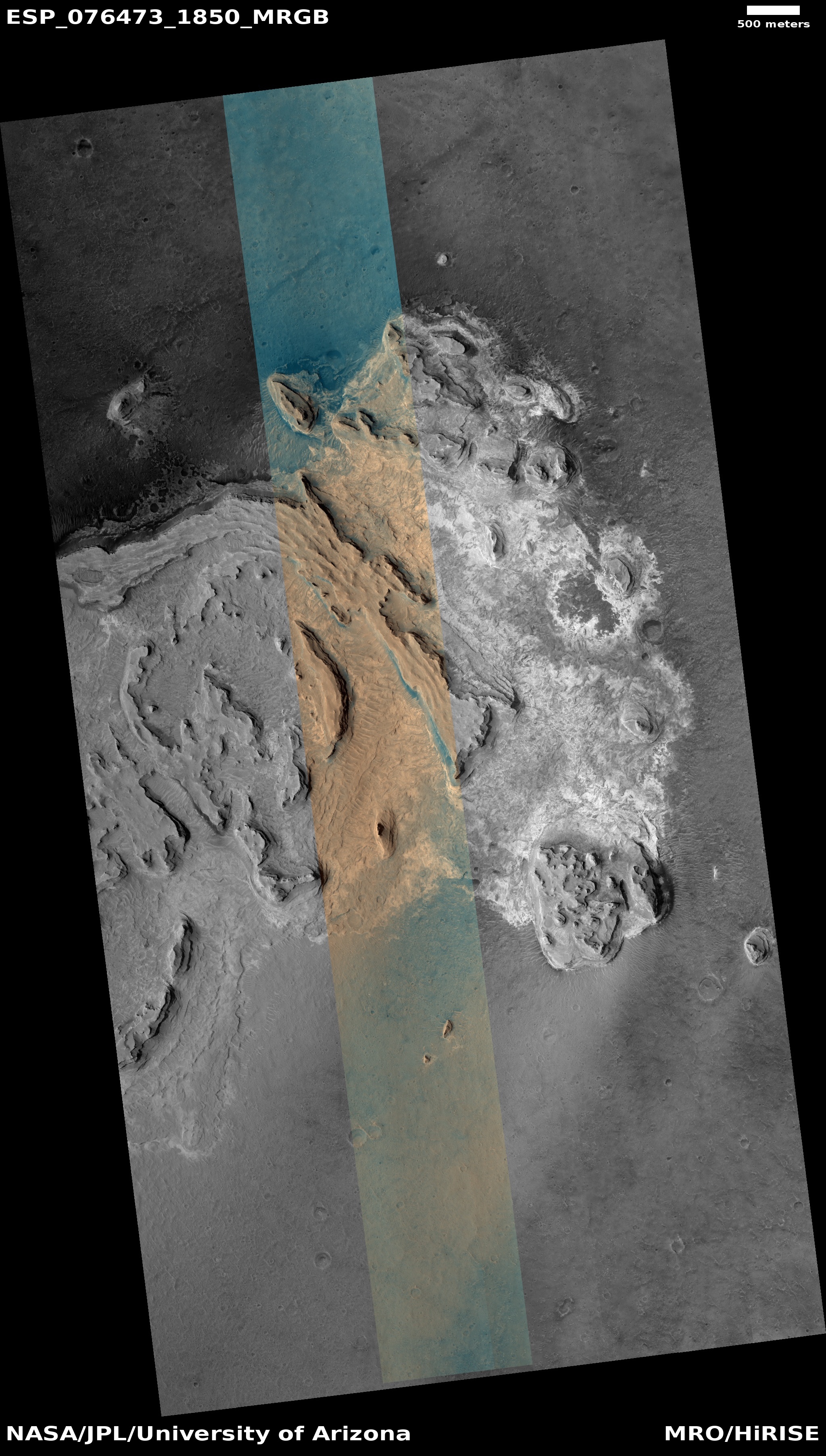
Cool image time! The picture to the right, rotated, cropped, reduced, and sharpened to post here, was taken on November 19, 2022 by the high resolution camera on Mars Reconnaissance Orbiter (MRO). It shows a collection of terraced mesas covered with dust of a variety of colors.

The bluish colors suggest exposed bedrock, while the different shades of tan suggest areas covered by dust and volcanic ash. That the tan areas are likely dust is strengthened in that it is found between and on these rough mesas, where dunes are also seen. The dust gets blown in but gets trapped there.

The tan colors however could also indicate different types of bedrock, especially because different terraces seem to be of different shades. We will need more data to determine which, or whether this is a combination of all these geological processes.
» Read more

0 comments

Curiosity takes high resolution panorama of the canyon it will soon enter

Curiosity looks into Gediz Valles
Click for original image.

Using its high resolution camera, the Curiosity science team has now released a November 2022 panorama looking south into Gediz Vallis, the Martian slot canyon that the rover will be entering in the near future.

The panorama above, cropped and reduced to post here, shows that canyon. The red dotted line indicates Curiosity’s approximate path since the panorama was taken, circling around behind Chenapua.

The mosaic is made up of 18 individual images that were stitched together after being sent to Earth. The color has been adjusted to match lighting conditions as the human eye would see them on Earth.

Not only should you definitely look at the original, at full resolution, but also compare it with the black and white mosaic I posted in December 2022, taken by the rover’s navigation camera looking in the same direction though from a slightly different position. The color definitely underlines the spectacular nature of the landscape.

7 comments

Curiosity scientists find evidence of lake water higher on Mount Sharp than expected

Panorama as of January 17, 2023
Curiosity’s view of the marker band on January 17, 2023, the red dotted line the planned future route. Click for full image.

The science team for the Mars rover Curiosity today revealed that the marker band layer where the rover present sits shows some of the best evidence of liquid water and waves yet seen on Mount Sharp, and it has been found much higher on the mountain than expected.

Having climbed nearly a half-mile above the mountain’s base, Curiosity has found these rippled rock textures preserved in what’s nicknamed the “Marker Band” – a thin layer of dark rock that stands out from the rest of Mount Sharp. This rock layer is so hard that Curiosity hasn’t been able to drill a sample from it despite several attempts. It’s not the first time Mars has been unwilling to share a sample: Lower down the mountain, on “Vera Rubin Ridge,” Curiosity had to try three times before finding a spot soft enough to drill.

Scientists will be looking for softer rock in the week ahead.

As Curiosity climbs the mountain it transitions onto new younger layers of rock. Based on Curiosity’s earlier data lower down the mountain, scientists had assumed it had gone from layers that had been under a past lake to layers that were at the lake’s shoreline to layers where only running water once flowed. They had thought the marker layer and other higher layers would only show evidence of running water. Instead, in the marker layer they have once again found evidence of an ancient lake.

This quote by Ashwin Vasavada, Curiosity’s project scientist, sums things up nicely: “Mars’ ancient climate had a wonderful complexity to it, much like Earth’s.”

0 comments

Dormant volcanic vent on Mars

Dormant volcanic vent on Mars
Click for original image.

Cool image time! The photo to the right, rotated, cropped, and reduced to post here, was taken on November 19, 2022 by the high resolution camera on Mars Reconnaissance Orbiter (MRO). It shows what the science team labels “Intersecting Fissures.”

These fissures stand out distinctly on this terrain. If you look at an MRO context camera image, showing a wider view, you can see that the surrounding plain is relatively featureless, with few craters. Except for some strange and inexplicable dark streaks close by to the east, some mottled but flat terrain to the north, and a long but very faint similar east-west fissure to the south, this runelike fissure is the only major topological feature for miles around.

That context camera image also shows that this fissure sits on top of a very faint bulge, with hints that material had flowed downhill from the fissure’s western and southern outlets. Located very close to the equator, it is unlikely that any of those flow features are glacial, and in fact they do not have that appearance in the context camera picture. Instead, they have the look of Martian lava, fast-moving and far less viscous than Earth-lava, and thus able to cover large areas much more quickly.

Thus, all the evidence says that this feature is a dormant volcanic vent, sitting on a flood lava plain. And the overview map below cements this conclusion.
» Read more

1 comment

The landing sites for two upcoming lunar landers

Map of Moon's south pole
Click for interactive map.

The approximate landing sites for two different lunar landers have now been revealed.

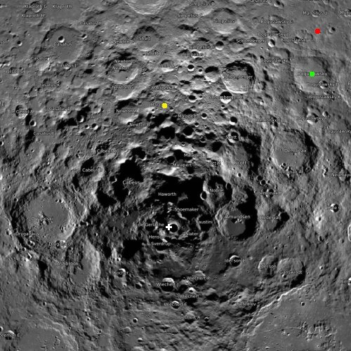
The map to the right, with the south pole indicated by the white cross, shows both, plus the planned landing site for Russia’s Luna-25 lander, presently targeting a summer ’23 launch. The green dot marks Luna-25’s landing site, inside Boguslawsky Crater.

The red dot marks the landing site in for India’s Chandrayaan-3 lunar lander/rover, now tentatively scheduled for launch by the end of ’23. This mission will put a small rover on the surface, and is essentially a redo of the failed Chandrayaan-2 mission from 2019.

The yellow dot in Malapert-A crater is now the likely landing site for Intuitive Machines Nova-C lander. This site is a change from the spacecraft’s original landing site in Oceanus Procellarum (where Astrobotic’s Peregrine lander is now going). In making this change, the launch of Nova-C also slipped to late June 2023, from the previously announced launch date of early 2023.

2 comments

Perseverance and Ingenuity begin the journey up onto Jezero Crater’s delta

Perseverance's view ahead, February 7, 2023
To see the original images, go here and here.

Overview map
Click for interactive map.

After two years of detailed exploration on the floor of Jezero crater, the rover Perseverance and its Mars helicopter scout Ingenuity have finally begun the climb up onto the delta that in eons past flowed into Jezero Crater.

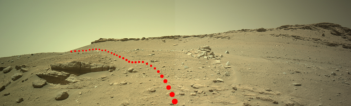
The panorama above was created from two Perseverance images taken by its right navigation camera on February 7, 2023 (Sol 699) (here and here), looking forward and uphill. On the overview map to the right the blue dot marks Perseverance’s location, with the yellow lines indicating the approximate area covered by this mosaic. The red dotted line in both images indicate approximately the rover’s eventually path.

Ingenuity’s present position is marked by the green dot. This is where the helicopter landed after completing its 42nd flight on February 4, 2023. Planned to fly 823 feet for 137 seconds, Ingenuity actually flew a slightly shorter distance, 814 feet, in that length of time. The difference is probably the result of Ingenuity’s need to find a good landing spot, and the one it found was slightly closer to its take-off point.

The flight however took the helicopter uphill, scouting the terrain that Perseverance plans to drive. While there is no terrain here that is much of a challenge for the rover, having the helicopter’s ground images in advance allows its operators to plan longer drives, as those images will help tell them what obstacles to avoid and route to choose.

The green oval indicates the area that Perseverance has left its first ten core samples for later pickup and return to Earth.

0 comments
1 78 79 80 81 82 89