ESA invites private companies to build lunar satellites for communications and navigation

Capitalism in space: The European Space Agency (ESA) has now invited European and Canadian companies to build the lunar communications and navigation satellites that will be needed to serve the many future manned and unmanned missions presently being planned by the U.S. and Europe.

Under its Moonlight programme, ESA is inviting space companies to create these lunar services.

By acting as an anchor customer, ESA is enabling space companies involved in Moonlight to create a telecommunication and navigation service for the agency, while being free to sell lunar services and solutions to other agencies and commercial ventures.

Once Moonlight is in place, companies could create new applications in areas such as education, media and entertainment โ€“ as well as inspiring young people to study science, technology, engineering and maths, which creates a highly qualified future workforce.

According to the press release, almost 100 companies have already expressed interest.

It is however unclear how much freedom the companies will have in designing and creating these satellites, based on ESA’s own descriptions of the project. It appears that ESA wants to design them, and is simply looking for private companies to build them. Under this arrangement, ownership will not belong to the companies, even if they are given the freedom to make money selling the capability to others. In fact, past history suggests that in the end, ESA will eventually retract this part of the deal, because of its desire to fully control the satellites it designed.

2 comments

Drilling success for Curiosity in the marker layer?

Curiosity's view ahead, February 25, 2023
Click for full panorama.

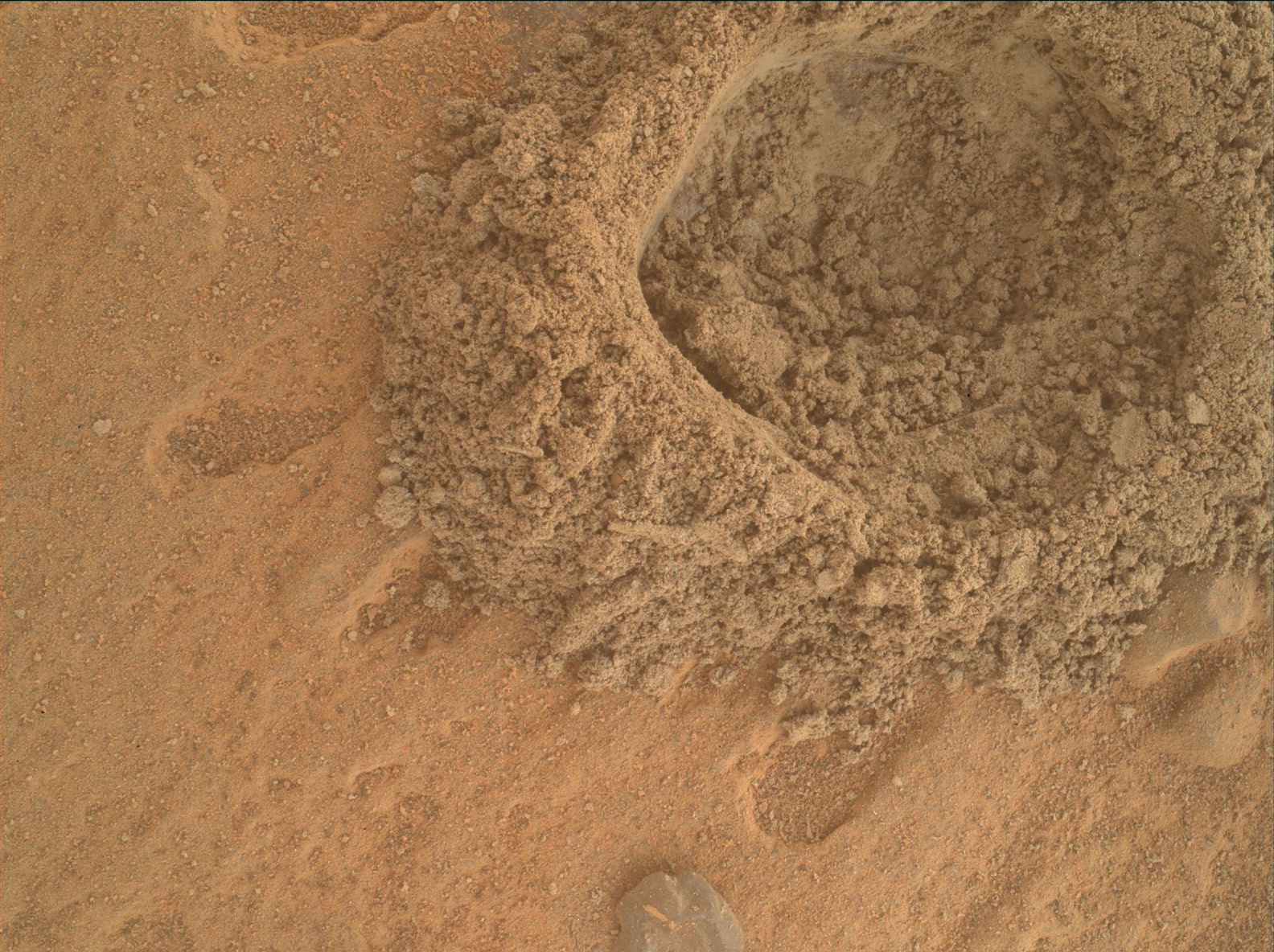
The fifth drill hole in the marker band
Click for original image.

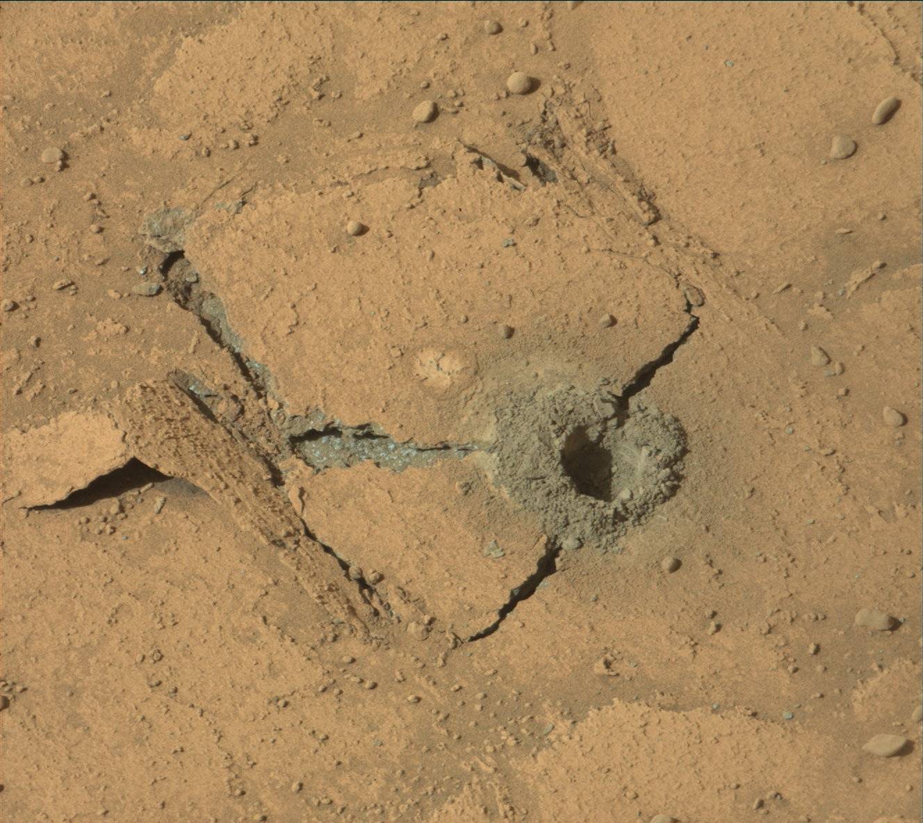
It appears from the most recent image sent back from Curiosity today of its February 25, 2023 attempt to drill into the marker layer on Mount Sharp — the fifth such attempt — the rover finally succeeded in getting deep enough to collect sufficient sample material for analysis.

That image is to the right, cropped, reduced, and sharpened to post here. Note that it is not yet confirmed from the science team that this drill attempt was deep enough. What makes this particular drilling attempt intriguing is how the many thin layers of the marker layer responded to the stress of the drill. The top layer cracked like a plate and separated from the adjacent lower layer during drilling. It apparently was hard enough to retain most of its structure, and rather than crumble the drill stresses caused a large section to break away and lift off.

The panorama above, cropped and reduced to post here, was taken the same day from this location, produced from 37 photos taken by the rover’s right navigation camera. The cropped section above looks forward at what I previously labeled “a Martian hill of pillows.” The overview map below shows the context of this panorama.
» Read more

2 comments

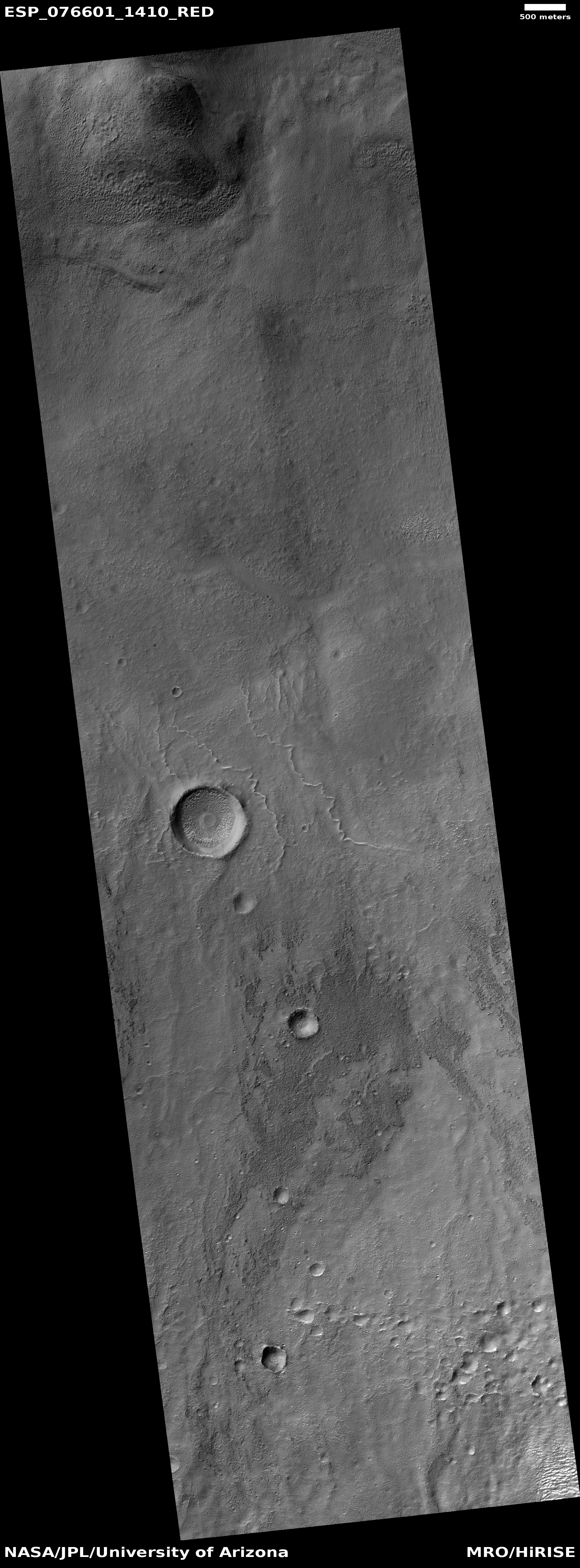
Meandering ridges in Greg Crater

Meandering ridges in Greg Crater
Click for original image.

Cool image time! The picture to the right, cropped, reduced, and sharpened to post here, was taken on November 29, 2022 by the high resolution camera on Mars Reconnaissance Orbiter (MRO). It shows what the scientists label “curved ridges.”

These might be inverted channels, the beds on which either water or ice flowed, compacting it down so that it became very resistant to erosion, and thus remains when the surrounding terrain was worn away. However, none of them seem to follow any grade. A more likely explanation is that these are ancient moraines, the debris pile pushed ahead of a glacier and then left behind when the glacier goes away.

The location is the reason I favor this explanation.
» Read more

0 comments

Scientists pin down Venus’s most likely active volcanic regions

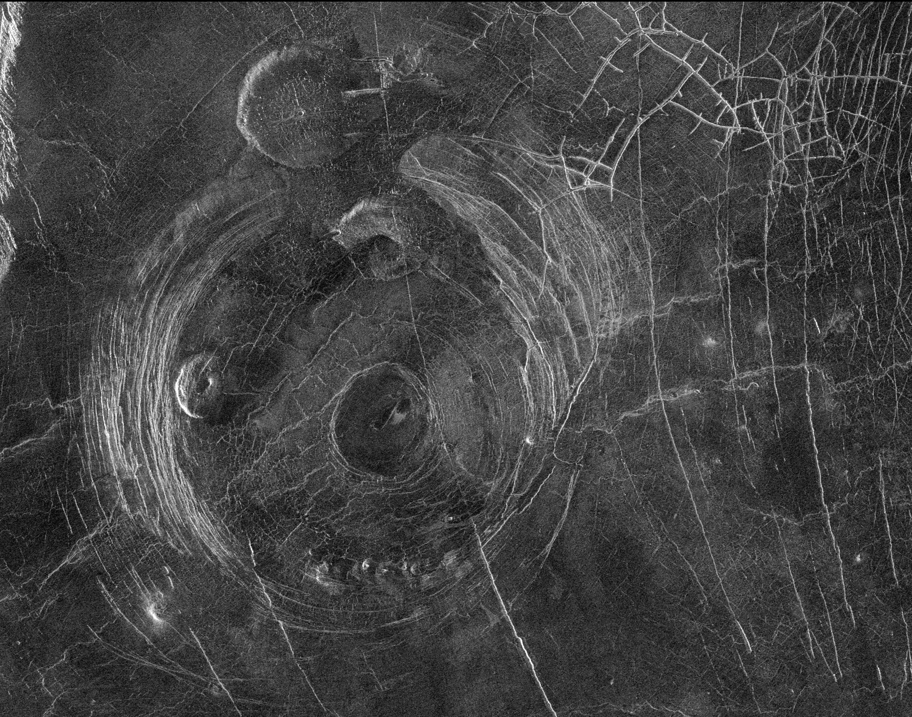
The Aine corona on Venus
The Aine corona on Venus, about 124 miles in diameter.
Click for original image.

Using archival data from the Magellan radar imaging Venus orbiter from the early 1990s, scientists think they have identified the regions Venus that are most likely to have active volcanoes, places that have a unique Venusian circular feature called coronae.

The researchers focused on 65 previously unstudied coronae that are up to a few hundred miles across. To calculate the thickness of the lithosphere surrounding them, they measured the depth of the trenches and ridges around each corona. What they found is that ridges are spaced more closely together in areas where the lithosphere is more flexible, or elastic. By applying a computer model of how an elastic lithosphere bends, they determined that, on average, the lithosphere around each corona is about 7 miles (11 kilometers) thick โ€“ much thinner than previous studies suggest. These regions have an estimated heat flow that is greater than Earthโ€™s average, suggesting that coronae are geologically active.

Thus, more volcanic activity, releasing the planet’s interior heat outward.

This research confirms other work done looking at coronae back in 2020.

0 comments

Ingenuity completes 45th flight; Perservance races to keep up

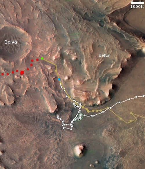
Overview map
Click for interactive map.

On February 22, 2023, the Mars helicopter Ingenuity completed its 45th flight on Mars, flying 1,627 feet in 2 minutes and 24 seconds. This was 13 feet farther than planned, and 5 seconds longer, the extra distance likely because the helicopter needed to find a good landing spot.

The green dot on the map to the right indicates Ingenuity’s new position. The blue dot marks Perseverance’s position. The rover has been moving fast, quickly climbing up onto the delta behind Ingenuity only days after it has completed each recent flight. It appears the Perseverance science team wishes to reach the top of the delta as fast as possible, where it can then begin drilling for more core samples.

It is becoming increasing clear the limitations of Perseverance. It was designed to obtain these core samples for return to Earth, but in the process many of the geological tools and sensors that Curiosity carries were eliminated. The result is the Perseverance can’t actually find out as much about the geology in Jezero Crater as Curiosity can. This doesn’t mean it can’t do any geological work, because it certainly can, but all of the analysis of drill samples that Curiosity does is beyond Perservance’s capabilities. It basically can only do contact science and close inspection. The analysis of its drilled samples must wait until the samples are returned to Earth, about a decade from now.

0 comments

February 23, 2023 Quick space links

Courtesy of BtB’s stringer Jay.


  • Russia now targets a July 13, 2023 launch date for its Luna-25 Moon lander
  • Though this mission has been delayed endlessly, and Russia has also been forced to delay its later planned unmanned lunar probes due to its lack of certain components formerly obtained from the west before its invasion of the Ukraine, I now expect this launch to happen on that date or reasonable close to it.

11 comments

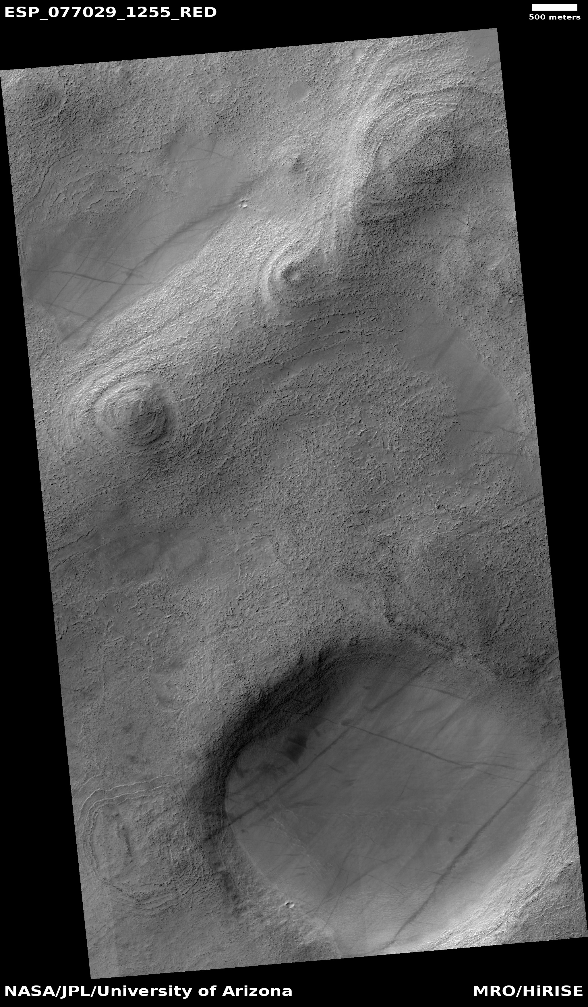
Soft Martian buttes

Soft Martian buttes
Click for original image.

Cool image time! The picture to the right, rotated, cropped, reduced, and sharpened to post here, was taken on January 1, 2023 by the high resolution camera on Mars Reconnaissance Orbiter to fill a gap in its shooting schedule so that the scientists could maintain the camera at its proper temperature.

In other words, the picture was not taken as part of any particular research project. Its target was in a sense chosen almost at random, though the science team always tries to find something of interest in such situations. In this case I think they succeeded, as these soft terraced buttes illustrate well the alien nature of Mars. The ground is barren, with absolutely no evidence of any life, and it appears that the buttes have been softened and eroded by eons of wind action. You can see evidence of this by the handful of dust devil tracks that cross the buttes.

There is more.
» Read more

0 comments

Cliffs inside 285-mile-wide Schiaparelli Crater on Mars

Cliffs inside Schiaparelli Crater
Click for original image.

Cool image time! The picture to the right, rotated, cropped, reduced, and sharpened to post here, was taken on December 2, 2022 by the high resolution camera on Mars Reconnaissance Orbiter (MRO), and was labeled by the science team as showing “dramatic cliffs and swirls in mound-skirting unit.”

I estimate the tallest point of this cliff butte to be somewhere between 500 and 800 feet high. And while the cliff is what first attracts the eye, one mustn’t ignore the vast amounts of dust and sand that cover everything here. The small teardrop-shaped buttes on the upper plateau suggest the prevailing wind direction there is from the north to the south. However, the north-south orientation of the ripple dunes on the floor below suggests that the prevailing wind direction below the cliff is east-west. Explaining how the topography could so quickly change the prevailing wind direction is beyond my skill.

The swirls mentioned by the scientists can be seen at the top of the cliff (on the left) and just below its base, in areas where there appears to be less dust. Those swirls reveal the many geological layers here.
» Read more

1 comment

China’s continued silence about Zhurong suggests Mars rover is dead

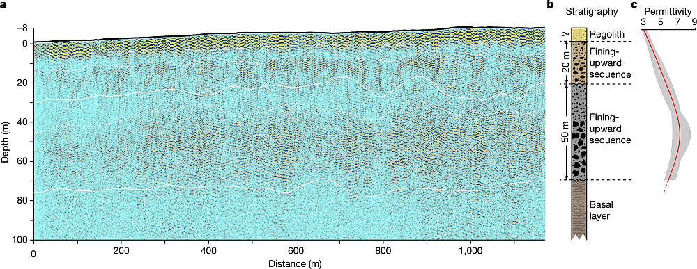
Zhurong's ground-penetrating radar data
The data from Zhurong’s ground-penetrating radar instrument.

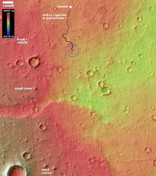
Overview map
Zhurong’s final location is somewhere in the blue circle.

China’s continued silence about Zhurong — which should have come out of hibernation sometime in late December-early January — suggests the Mars rover did not survive the Martian winter, which this year was also lengthened near the end by some additional dust storms.

Zhurong went into hibernation in May 2022, at the start of winter, with plans to awaken in December. Like the helicopter Ingenuity and the lander InSight, it depends on solar power, and had to contend with a very relatively severe winter dust season this Martian year.

Even though the Chinese press has loudly touted Tianwen-1’s first two years in Mars orbit, it has made little or no mention of Zhurong, a silence that is deafening.

The silence is also foolish, because China has nothing to be ashamed of concerning Zhurong. The mission was only supposed to operate for 90 days. Instead it lasted more than a year, traveling much farther than planned. Most important, the data from its radar instrument (shown above) showed that, at this location at 25 degrees north latitude, there is no underground ice to a depth of 260 feet. That data confirmed that the Martian equatorial regions below 30 degrees latitude are very dry, with any underground ice existing rarely if at all. The icy regions above 30 degrees latitude do not appear to extend much farther south than that latitude.

0 comments

Splashed lava from a Martian impact

Splashed lava from a Martian impact
Click for original image.

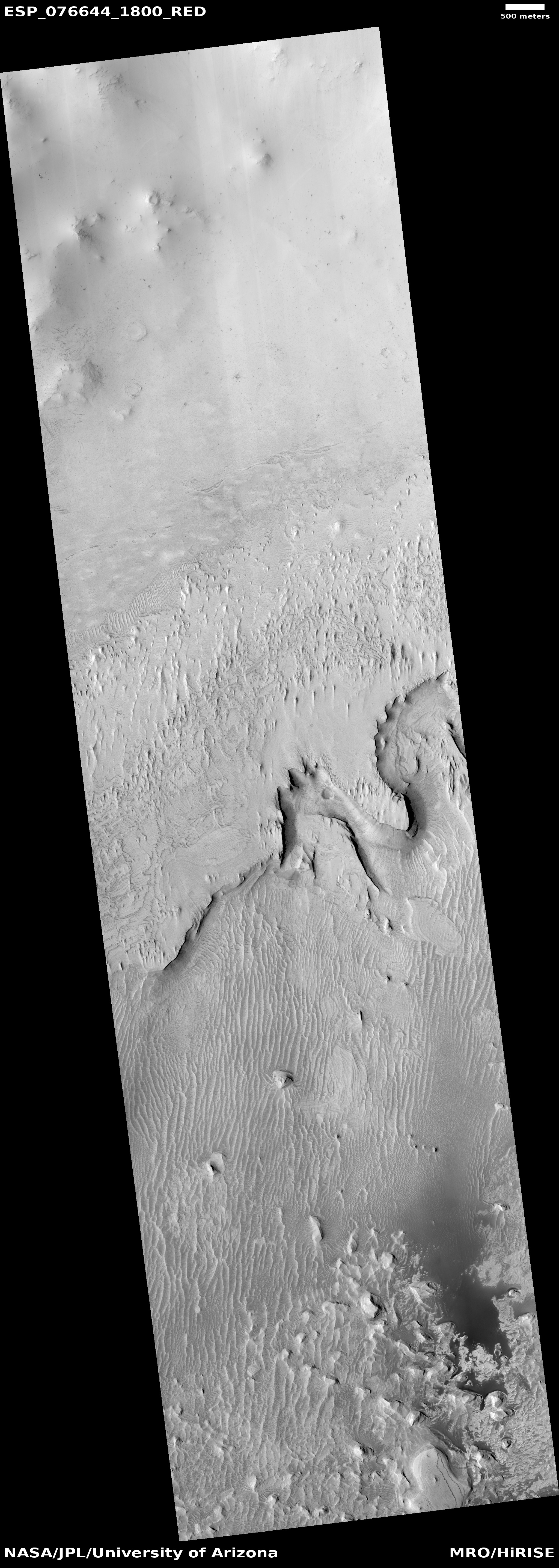
Almost always it is impossible to understand a high resolution image from Mars Reconnaissance Orbiter (MRO) unless you also take a wider view. Today’s cool image to the right, rotated, cropped, reduced, and sharpened to post here, is a perfect example.

Taken on January 6, 2023, it shows what the science team labeled as a “rocky deposit on crater floor.” To my eye however none of this appeared tremendously rocky. Instead, what I saw was a curved and layered flow feature whose ancient age was suggested by the many later craters scattered across its surface.

Still, its origin was unclear. It isn’t ice, not only because of its apparent resistance from disturbance from those later crater impacts but because it is located at about 20 degrees north latitude, in the dry equatorial regions of Mars. If lava, what is its source? As I noted, a wider look was necessary to answer that question.
» Read more

0 comments

For the 4th time Curiosity’s drill fails to penetrate marker layer

Failed drillhole by Curiosity in marker layer
Click for original image.

For the fourth time this past weekend Curiosity’s drill was unable to penetrate the hard rock of what scientists have labeled “the marker layer”, a distinct feature seen at approximately the same elevation at many places on the flanks of Mount Sharp on Mars.

The image to the right, cropped and reduced to post here, shows that the drill was once again only able to drill a eighth to a quarter inch, not enough to gather samples for testing.

This was our fourth attempt to drill this marker band, and we gave it our best shot from both a geology and engineering perspective. Unfortunately these rocks do not want to cooperate โ€“ theyโ€™re hard and they weather into resistant and recessive beds which make them very challenging to drill. So the team made the difficult decision to get back on the road, without a drill sample from this location

» Read more

6 comments

India’s Chandrayaan-3 lunar lander/rover passes radiation testing


Click for interactive map.

According to India’s space agency ISRO, its next lunar lander/rover, Chandrayaan-3, has successfully passed testing to make sure it can function without issues in the harsh electromagnetic environment of space.

Magnetic Interference/ Electro – Magnetic Compatibility) test is conducted for satellite missions to ensure the functionality of the satellite subsystems in the space environment and their compatibility with the expected electromagnetic levels.

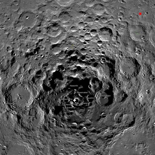
The spacecraft, which will carry a rover to the Moon’s south pole regions (the red dot on the map to the right), is tentatively scheduled for launch anywhere from June to the end of ’23, depending on the news story you read.

0 comments
1 77 78 79 80 81 89