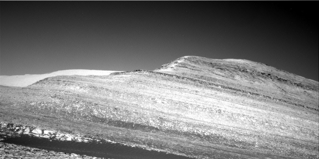
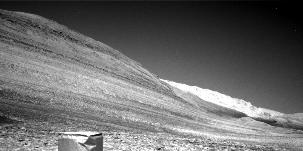
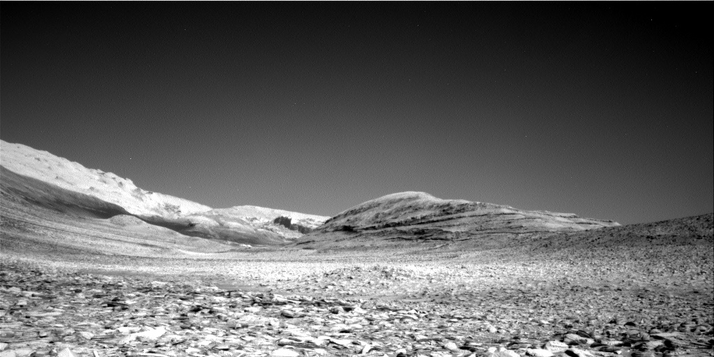
Gale Crater as seen by Curiosity from the heights of Mount Sharp

Gale Crater as seen by Curiosity from the heights of Mount Sharp
Click for original image.
Overview map
Click for interactive map.

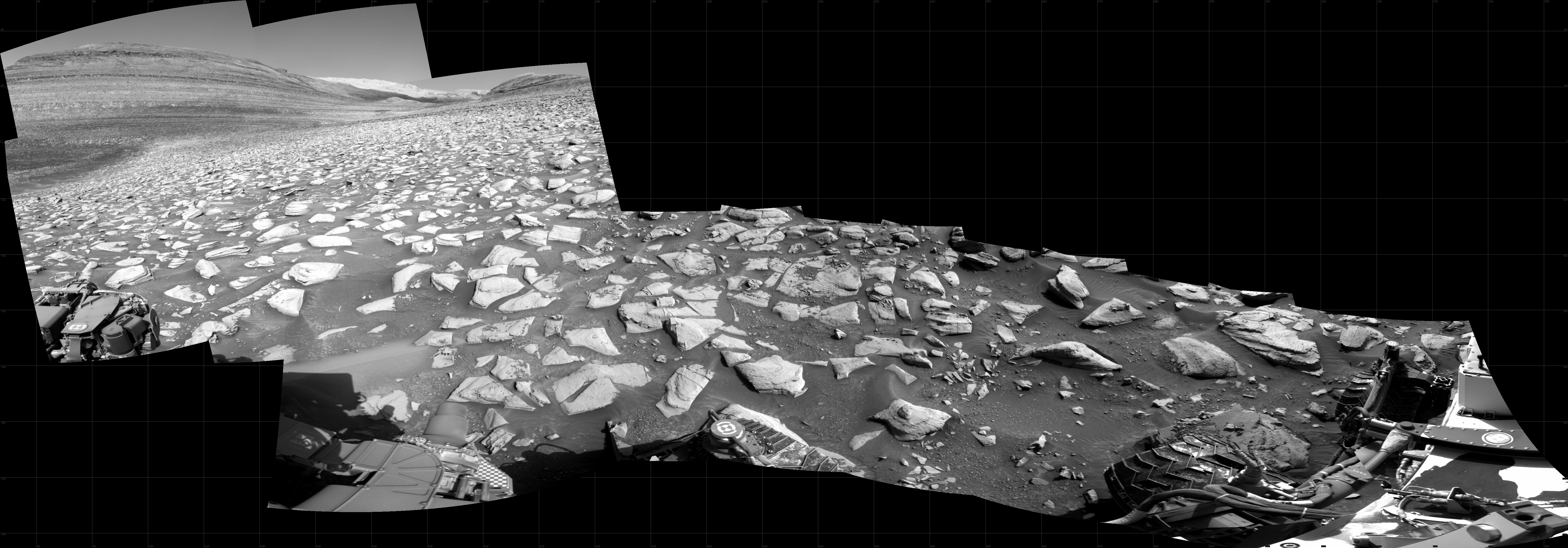
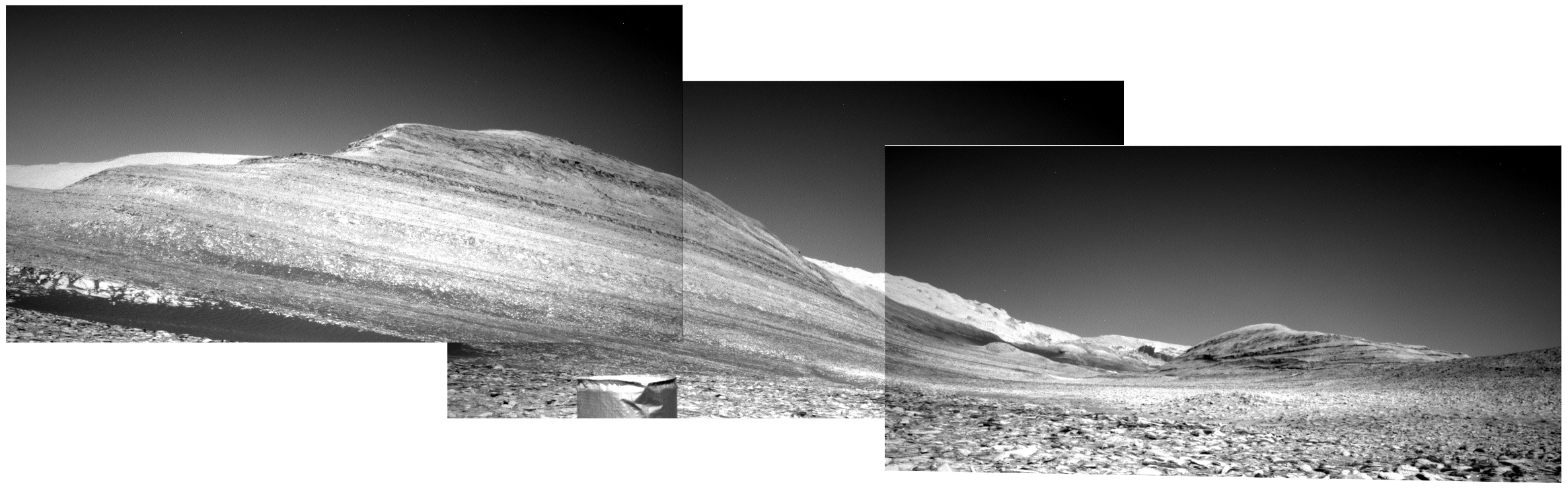
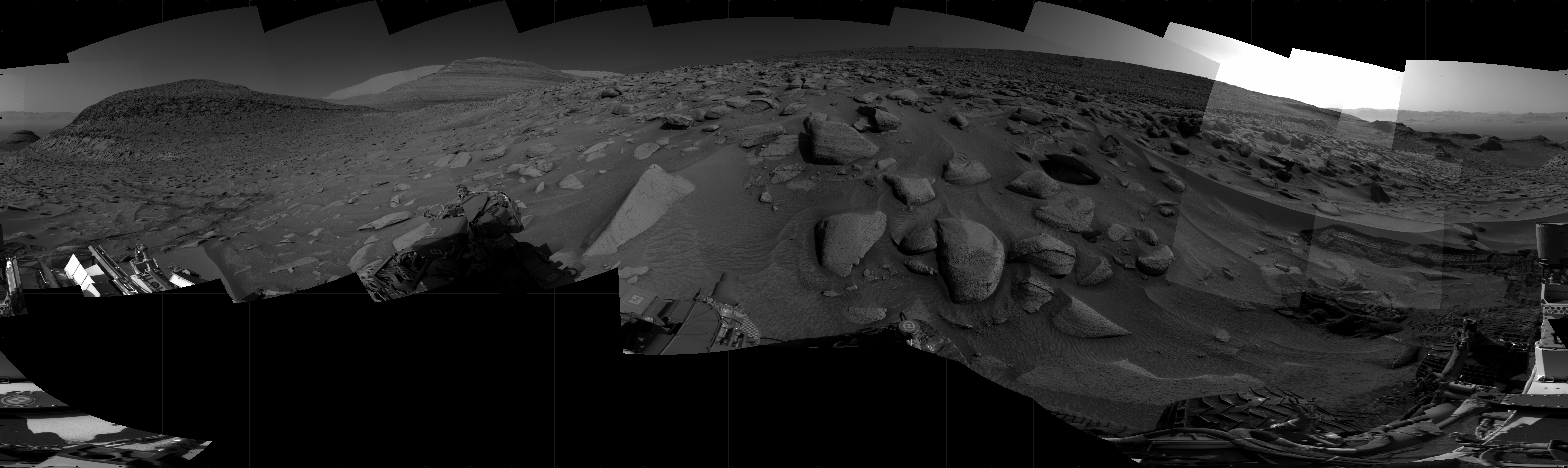
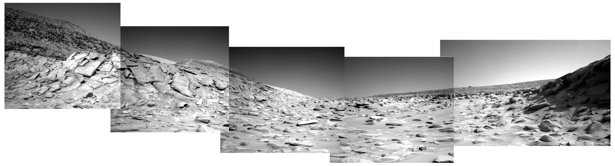
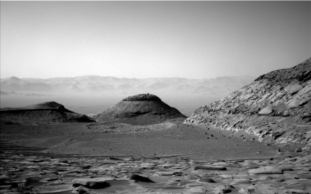
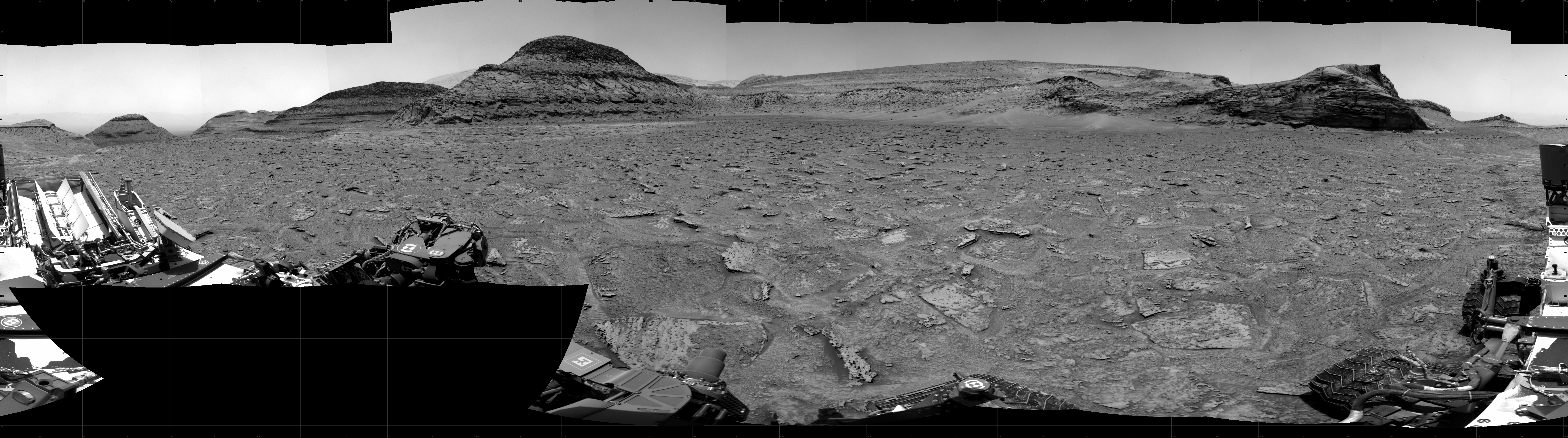
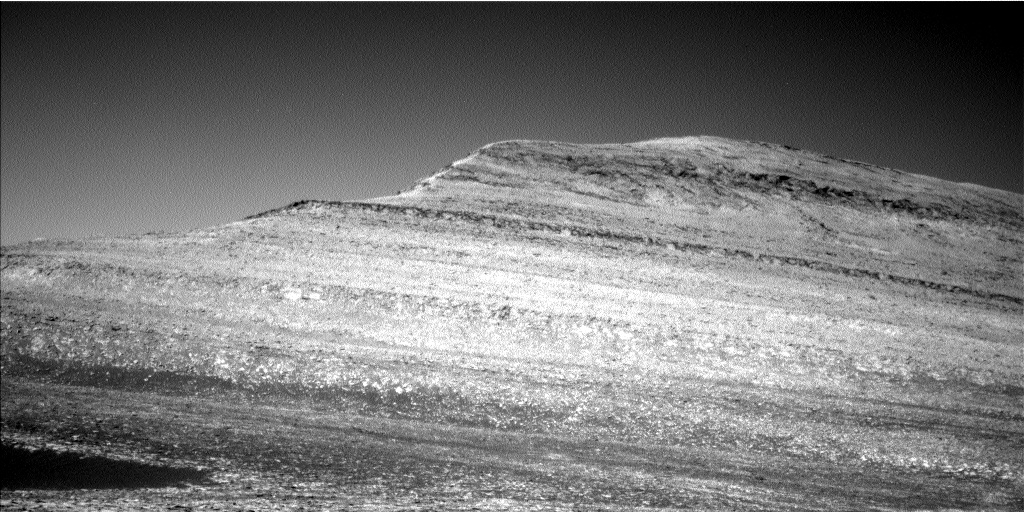
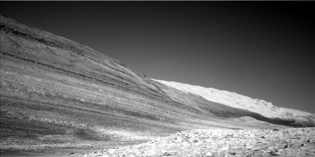
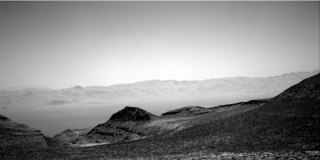
Though Curiosity still lies more than 13,000 feet below the peak of Mount Sharp, in its ten years on Mars it has climbed a considerable distance uphill since leaving the floor of 97-mile-wide Gale Crater, about 2,400 feet. The panorama above, taken today by one of Curiosity’s navigation cameras and rotated and cropped to post here, gives us a good sense of the elevation the rover has gained in that time.

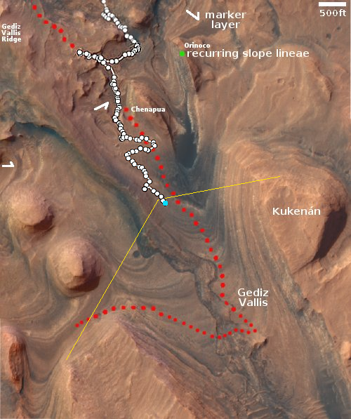
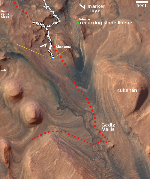
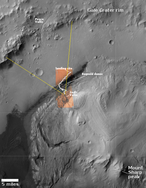
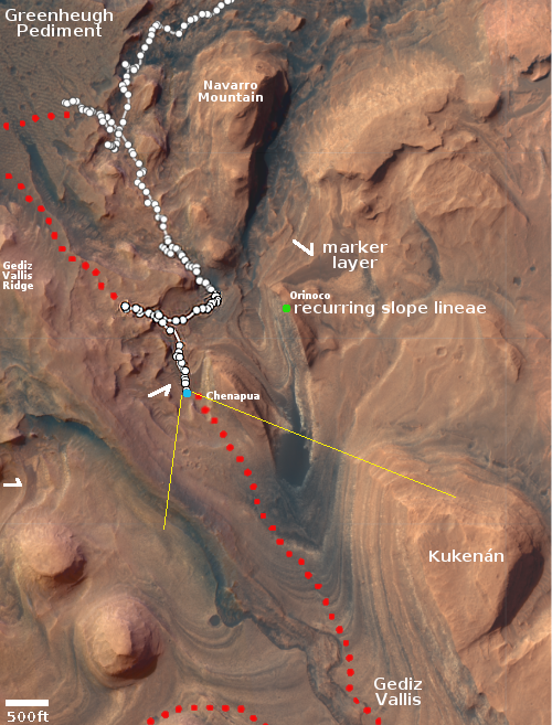
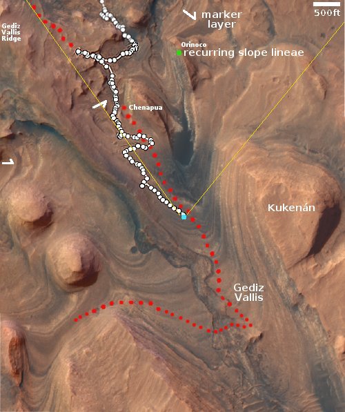
The overview map to the right provides some perspective. Curiosity’s present location is indicated by the blue dot, with the yellow lines indicating the direction of this panorama. Though Curiosity climbed up from that valley on the lower left, none of its route is visible in this picture, as the weaved up from the left and the steepness of the ground hides the lower sections.

The mountain chain in the distance, about 20 to 25 miles away, is the north rim of Gale Crater. Beyond it can faintly be seen other mountains, which form the rim of another smaller crater to the north. The peak of Mount Sharp, about 23 miles to the south and in the opposite direction, forms the wide central peak of Gale Crater, unusual in that it fills much of the crater and rises higher than the crater’s rim, factors which were part of the reason this location was chosen as Curiosity’s landing site.

This picture also allows scientists to get a sense of the dust levels in the Martian atmosphere, which change seasonally depending on dust storm activity. Since it is now summer on Mars, when dust activity is low, the air is relatively clear.

1 comment

Update on Curiosity’s journey in Mount Sharp, including its future route

Curiosity's future planned route
Click for original image.

The Curiosity science team yesterday released a new 360 panorama taken on August 19, 2023 by the rover’s high resolution camera, as part of an effort to document an important geological location finally reached after two previous attempts failed.

Three billion years ago, amid one of the last wet periods on Mars, powerful debris flows carried mud and boulders down the side of a hulking mountain. The debris spread into a fan that was later eroded by wind into a towering ridge [dubbed Gediz Vallis Ridge], preserving an intriguing record of the Red Planet’s watery past.

Now, after three attempts, NASA’s Curiosity Mars rover has reached the ridge, capturing the formation in a 360-degree panoramic mosaic. Previous forays were stymied by knife-edged “gator-back” rocks and too-steep slopes. Following one of the most difficult climbs the mission has ever faced, Curiosity arrived Aug. 14 at an area where it could study the long-sought ridge with its 7-foot (2-meter) robotic arm.

That panorama can be viewed here. The rover spent eleven days at this geological location, and has since moved on.

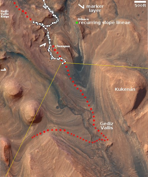
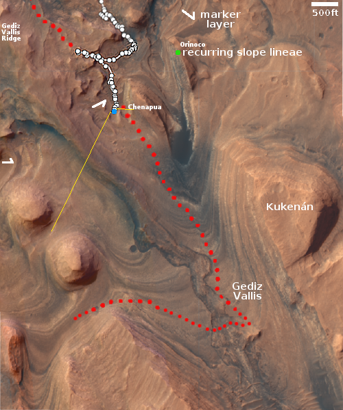
Because that panorama covers some of the same ground I have previously posted from the rover’s navigation cameras, I have instead posted above the graphic from the press release, with additional annotations, because that graphic provides new information about Curiosity’s future travels.

The white line marks Curiosity’s past travels as well as the planned route as previously released by the science team. The red line marks the additional route that the rover will follow beyond, weaving its way up Mount Sharp.

0 comments

Weird rocks on Mars

Weird rocks seen by Curiosity and Perseverance
For original images, go here and here.

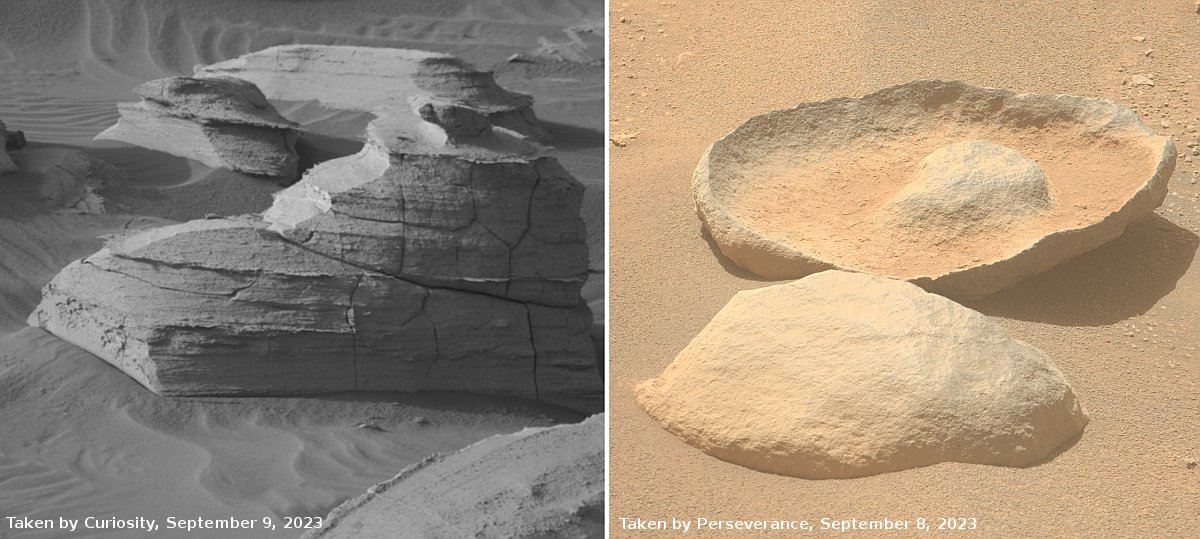
Time for two cool images, this time from both of the American rovers on Mars.

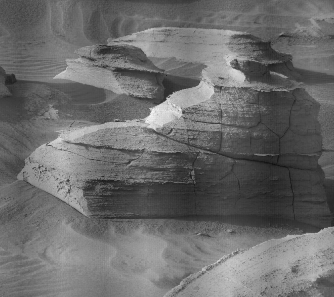
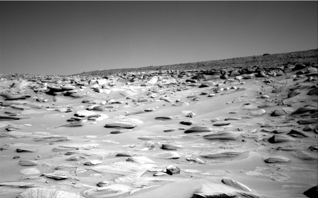
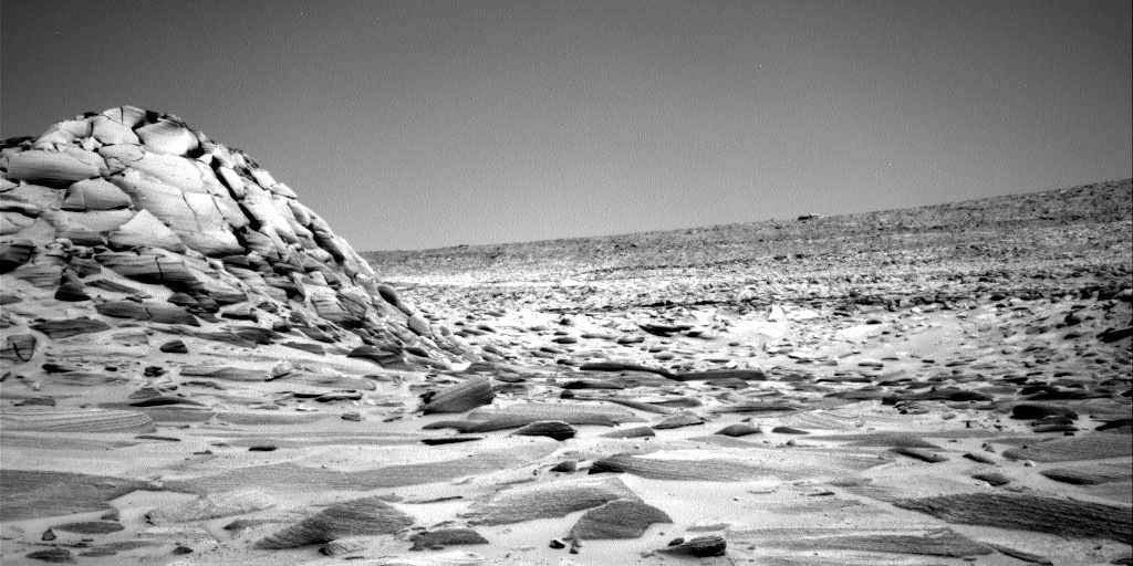
The left picture above was taken on September 9, 2023 by the high resolution mast camera on Curiosity. It shows what appears to be a many-layered but rounded rock which appears typical of the many boulders that cover the terrain through which Curiosity is presently traveling. In the past the layered rocks that Curiosity has observed lower on the flanks of Mount Sharp have not been rounded. Instead, the delicate layers have often extended outward at the rock’s edges, almost like paper or threads. For some reason, the layers in the rocks here have been eroded smooth, suggesting they were once covered by flowing water or ice, able to round the rough edges in a way that Mars’ thin atmosphere can’t.

What is puzzling is the location, higher on Mount Sharp. One would expect the reverse, with such erosion more typical lower on the mountain and uneroded delicate layers more common higher on the mountain.

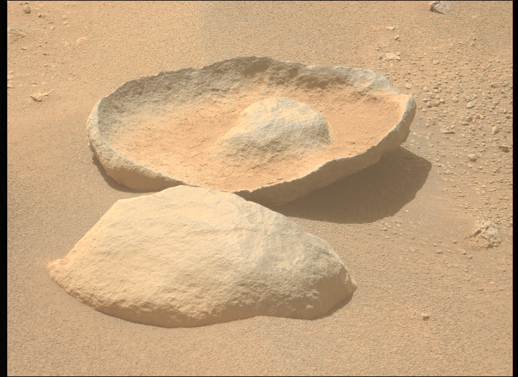
The right picture above was taken on September 8, 2023 by one of the high resolution mast cameras on the rover Perseverance in Jezero Crater, about 5,000 miles to west of Curiosity. It shows a rock whose shape is so strange it is hard to fathom a geological process that would result in this form. Possibly the rock was a surface layer on a larger round boulder, and the normal freeze-thaw cycle of Mars caused it crack off as one piece. The lump in the middle however makes this explanation questionable.

Also puzzling is the curved shape. On Mars almost no geological layers have been found that are curved. They are generally flat and horizontal, reflecting the lack of tectonic processes that on Earth often twist and squash layers.

2 comments

Curiosity’s upcoming travels on Mount Sharp

Curiosity's view on September 6, 2023
Click for original image.

Overview map
Click for interactive map.

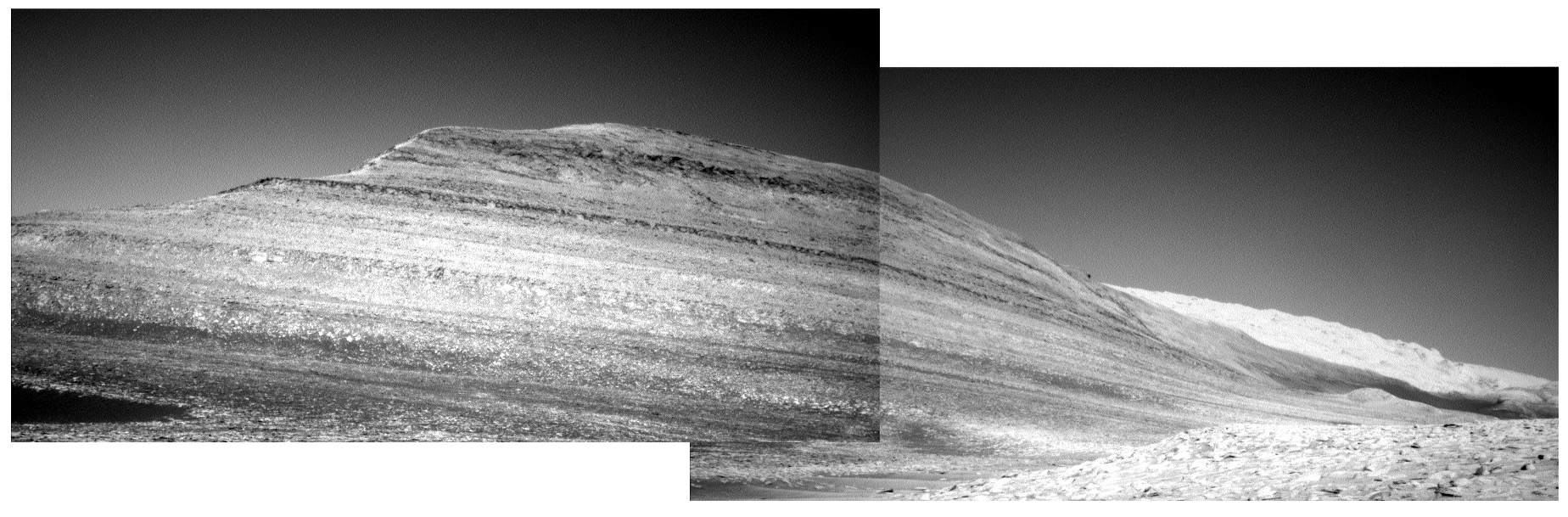
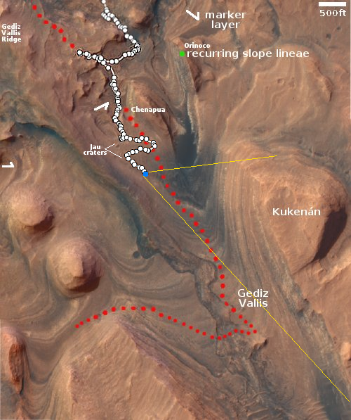
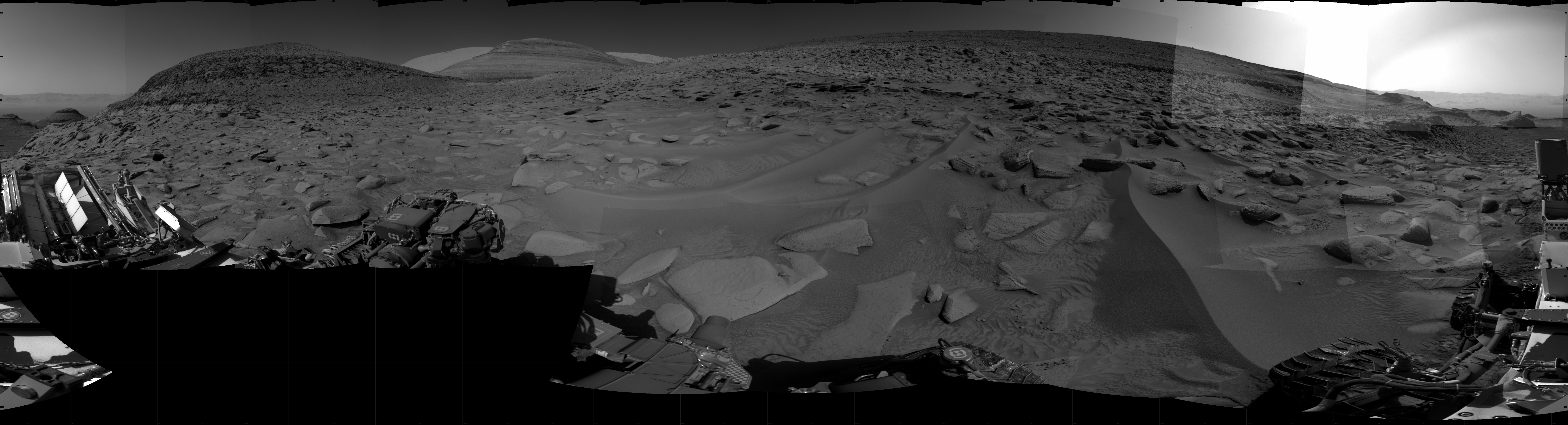
The panorama above, cropped, reduced, sharpened, and annotated to post here, was created on September 6, 2023 from eleven pictures taken by the right navigation camera on the Mars rover Curiosity.

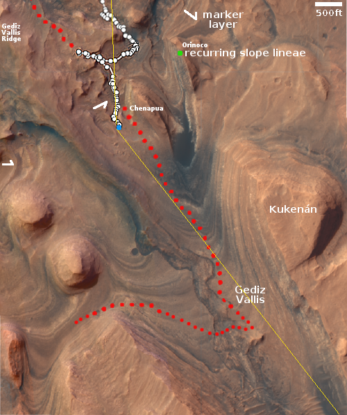
This mosaic looks south, into the slot canyon dubbed Gediz Valles. The red dotted line on the panorama as well as the overview map to the right indicates the planned route the science team plans on traveling as it sends Curiosity higher and higher on Mount Sharp. On the overview map Curiosity’s present position is indicated by the blue dot. The yellow lines show the approximate area covered by the panorama above.

As noted in today’s update from the science team:

The rover is currently driving across bumpy terrain consisting of rounded bedrock sticking up between dark sand and drift as she drives south, and slightly uphill, along the Mt. Sharp Ascent Route. Due to the rugged ground, the rover sometimes ends her drive with a wheel or two perched on a rock.

When the rover’s placement prevents use of the arm, the scientists have it do other things, such as take more images of the many layers on Kukenan.

As rocky as this future route is, it appears it is less rocky than earlier terrain, which the science team found impossible to traverse requiring several route detours. Thus, the pace forward has been a bit faster lately.

0 comments

Curiosity under the shadow of a Martian mountain

Panorama showing Kukenan on August 8, 2023
Click for full resolution. For original images, go here and here.

Overview map
Click for interactive map

Another cool image to start the week! The panorama above was created using two navigation images taken by Curiosity on August 8, 2023. It looks almost due west at the dramatic western wall of 400-foot-high Kukenan butte.

The blue dot on the overview map to the right marks Curiosity’s present location. The yellow lines indicate approximately the area covered by the panorama above. The red dotted line indicates the rover’s planned route.

Recently JPL issued a press release touting the efforts of its engineers to overcome the very steep and rocky terrain that Curiosity is presently traversing, an effort that I have documented repeated in the past few months (see posts here and here). They had been trying to send Curiosity straight up the mountain, to no success, and finally decided to do what every hiker and trail-maker does routinely, do back and forth switchbacks to reduce the grade per step.

In June they headed slowly uphill going east. In July they turned back and worked their way uphill going west, heading back to the Jau crater complex to get a quick look at these craters, then turned again in August to head back east, slowly working uphill along the contour lines. As they do this the rover is moving closer and closer to Kukenan, the largest butte so far studied in the foothills of Mount Sharp.

This panorama is one of the best illustrations of the very complex geological history of Mars. Each layer signals a past cycle in Mars’ very cyclic history, created because of the red planet’s wide swings of rotational tilt over time. Once underground, these layers have become exposed because erosion over the eons has slowly removed the material that once buried it, leaving the butte behind.

0 comments

Amidst the mountains on Mount Sharp on Mars

Panorama from Curiosity, July 12, 2023
Click for higher resolution. Original images can be found here, here, and here.

Overview map
Click for interactive map.

The panorama above, created from three images, was taken by Curiosity on July 12, 2023 using its right navigation camera. It looks south in the direction that the science team eventually plans to send the rover, as indicated by the red dotted line on both the panorama and the overview map to the right. The yellow lines on the overview map indicate approximately the area covered by the panorama. Kukenan’s peak rises about 500 feet above the rover, and I guarantee there will be many planetary geologists that are going to study the pictures of its many layers for many years.

At present however Curiosity is heading west, away from that planned route, to visit the small craters about 500 feet away. For almost all of the rover’s decade-long journey in Gale Crater, it has seen relatively few craters, and since it left the floor of the crater and began its climb up the flanks of Mount Sharp three years ago, it has seen none.

Inspecting the floors and surrounding ejecta of these small craters will give the scientists a look at materials that are presently below the surface. While it is likely that material will be of geological layers Curiosity has already traveled over lower down the mountain, it is also possible there will be surprises. The scientists decided they couldn’t pass up this opportunity to find out.

Why have there been so few craters in Gale Crater? Though Mars is hardly as active as Earth, its geological history is almost as dynamic. The surface of Gale has been reshaped by the processes that created Mount Sharp, processes that destroyed craters from early in Mars’ history. The craters the rover is about to see are almost certainly relatively young.

0 comments

Curiosity’s most damaged wheel appears to be surviving the rough terrain on Mount Sharp

Curiosity's middle left wheel, from November 2022 to July 2023
For original images go here and here.

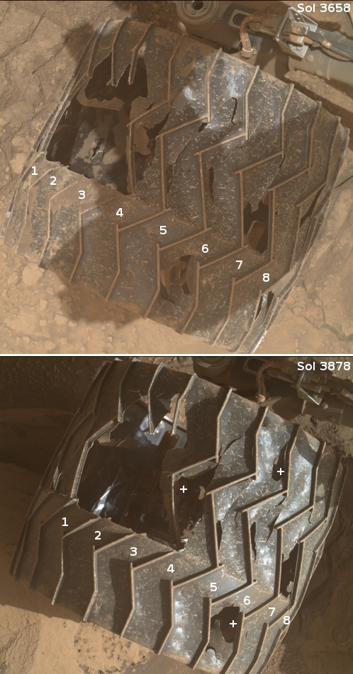
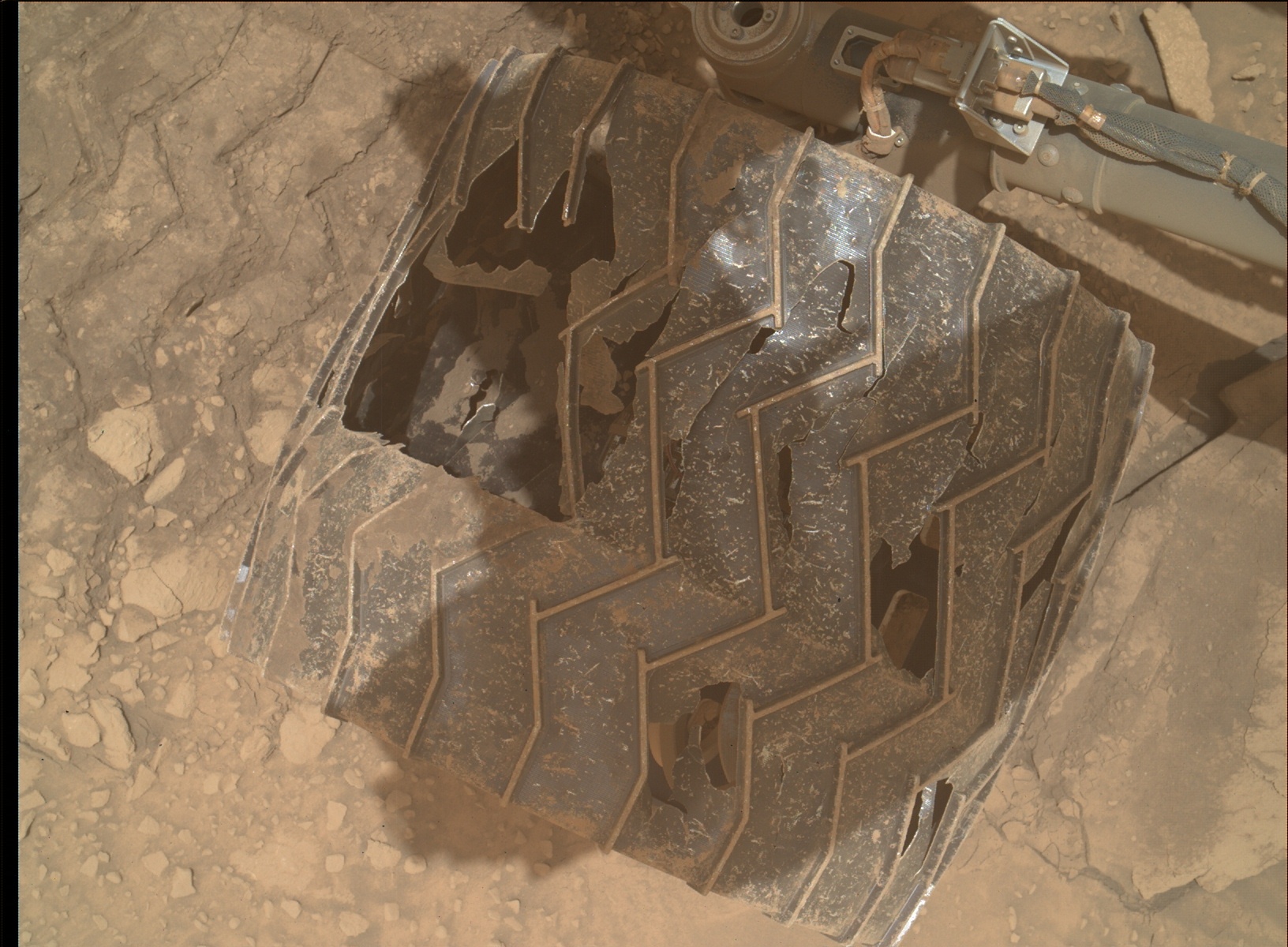
In today’s download of images from Curiosity was a set of pictures taken by its Mars Hand Lens Imager (MAHLI) of the rover’s wheels, as part of the science team’s routine inspection procedures after every 500 meters of travel.

The picture to the right shows what I think is the rover’s left middle wheel, its most heavily damaged, comparing what that wheel looks like now versus what it looked like in November 2022. At that time five of the wheel’s zig-zag grouser treads were broken, three of which are visible in both pictures. The numbers indicate identical wheel treads.

As you can see, after more than seven months of travel across some of the roughest and rockiest ground so far seen on Mars, no more grousers have broken in the new picture. The plus (“+”) signs indicate places where I think some additional metal between the grousers appears to have broken away, but even here the additional damage appears minimal.

Based on past wheel inspections, I expect more images will be taken in the next day or so. We shall see if those pictures indicate any further damage elsewhere. Based on this new picture, however, it appears that the care the science team takes in picking Curiosity’s route, as well as its software (designed to avoid the worst terrain), is continuing to preserve the wheels from further significant damage.

2 comments

Looking down a canyon on Mars

Looking down a canyon on Mars
Click for original image.

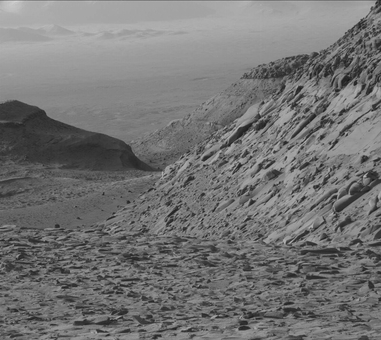
Cool image time! The picture to the right was taken on June 17, 2023 by Curiosity’s high resolution camera, looking back down Gediz Vallis and out across the distant floor of Gale Crater, far below. The white dotted line shows the route within this image where Curiosity had previously traveled inside this canyon, coming up around that shadowed mesa and then off to the west to try to get to terrain that it had earlier retreated because it was too rough on the rover’s wheels. Its subsequent path to the spot where this picture was taken was off to the left of the image, out of view.

This picture illustrates well the steepness and roughness of the mountainous canyon through which Curiosity presently travels. The small mountains visible on the floor of Gale Crater, about sixteen miles away, are no more than 450 feet high. The floor of the crater is 1,900 feet below where Curiosity present sits.
» Read more

7 comments

Curiosity looks back again as it climbs higher onto Mount Sharp

Panorama
Click for full panorama.

Overview map
Click for interactive map.

After completing several weeks of drilling, Curiosity has once again started climbing the rocky rough slope of Mount Sharp in Gale Crater, working its way up into the giant slot canyon dubbed Gediz Vallis.

The panorama above, cropped, reduced, sharpened, and annotated to post here, was created from 31 pictures taken on May 30, 2023 by the rover’s right navigation camera. It looks back both at Curiosity’s past travels climbing Mount Sharp as well as the now increasingly distant floor and rim of Gale Crater. The rim is about 20-30 miles away.

On the overview map to the right, the blue dot marks Curiosity’s position when this panorama was taken, with the yellow lines indicating the approximate area covered. The white dotted line on both the panorama and map indicates the rover’s actual route, with the red dotted line its planned route.

Because of the steep rough terrain, the science team has shifted the rover a bit to the west as it climbs. It is going to be fascinating to watch how it manages this climb into Gediz Vallis, as it appears the terrain is going to get no less steep or rough.

3 comments

Paperwork on Mars

Paperwork on Mars
Click for original image.

Cool image time! The picture to the right, cropped, reduced, and sharpened to post here, was taken on April 15, 2023 by the close-up camera on the Mars rover Curiosity. From the caption:

NASA’s Curiosity Mars rover took this close-up view of a rock nicknamed “Terra Firme” that looks like the open pages of a book, on April 15, 2023, the 3,800th Martian day, or sol, of the mission, using the Mars Hand Lens Imager (MAHLI) on the end of its robotic arm. The rock is about an inch across (2.5 centimeters).

Strange looking rocks like this have not been rare during Curiosity’s travels in Gale Crater, though it seems to me that the variety and strangeness has increased as the rover has climbed higher on Mount Sharp. In this case, the tall flake in the center — as well as the shorter flakes to the left — were among the many thin layers seen in this area. These layers however were clearly made of much harder material than the layers above and below. Those weaker layers eroded away over the eons, leaving behind these thin sheets.

Also, if you own red-blue 3D glasses, take a look at the anaglyph here.

3 comments

The climb into Gediz Vallis

Panorama on Sol 3808, April 24, 2023
Click for original image.

Overview map
Click for interactive map.

After three months traversing the geological layer that the scientists have dubbed the Marker Band, Curiosity has now climbed higher, passing what I dubbed the Hill of Pillows on the west so that it is now in a position to return to its planned route up Mount Sharp, as indicated by the red dotted line in the overview map to the right and the panorama above.

The panorama, cropped, reduced, and annotated to post here, was created on April 24, 2023 using 31 images from the rover’s right navigation camera. The yellow lines on the overview map indicate approximately the area covered, with the blue dot marking Curiosity’s present position.

For scale, the top of Kukenan is about 5,200 feet above Curiosity, while the top of Chenapua is only about 115 feet higher. The white flanks are about 3,200 feet above Kukenan, and are about 4 to 5 miles away.

Looking back, the rim of Gale Crater on the far left of the panorama is about 20 miles away.

0 comments

Curiosity gets a software update that will speed its travels and better protect its wheels

Panorama on March 27, 2023 (Sol 3781)
Click for full resolution panorama. The original images can be found here, here, here, here, and here.

Engineers this week completed a major software update on the Mars rover Curiosity that, among many other improvements, will allow it to travel more quickly across the rocky Martian surface but at the same time better protect its damaged wheels.

The team also wants to maintain the health of Curiosity’s aluminum wheels, which began showing signs of broken treads in 2013. When engineers realized that sharp rocks were chipping away at the treads, they came up with an algorithm to improve traction and reduce wheel wear by adjusting the rover’s speed depending on the rocks it’s rolling over.

The new software goes further by introducing two new mobility commands that reduce the amount of steering Curiosity needs to do while driving in an arc toward a specific waypoint. With less steering required, the team can reach the drive target quicker and decrease the wear that inherently comes with steering. “That ability was actually dreamed up during the Spirit and Opportunity days,” Denison said. “It was a ‘nice to have’ they decided not to implement.”

The software will also make it possible for Curiosity to travel more without the help of humans on Earth, which will also speed its travels up Mount Sharp, on ground that is getting increasingly rough, as shown in the mosaic above of navigation images from March 27th.

2 comments

Looking back from the foothills of Mount Sharp

Panorama looking back across Gale Crater, March 29, 2023
Click for original image.

Overview map
Click for interactive map.

The panorama above, cropped to post here, was taken today by the left navigation camera on the Mars rover Curiosity. It looks back at the rover’s previous travels, though only the terrain traveled in the past few months is visible, the rover having reached this point through the notch to the left of the distinctly dark mesa in the center of the picture. The lower flanks of Mount Sharp the rover traversed to get here are now blocked from view.

Instead, the image provides a spectacular example of the views north from Curiosity’s present position. The overview map to the right provides us the full context of the entire ten-plus year journey since Curiosity landed safely on Mars on August 5, 2012. The white squiggly line indicates the rover’s route. The yellow lines mark the approximate area covered by the panorama. The rim of Gale Crater is about 20-25 miles away.

As you can see, as spectacular as this view is, the journey up Mount Sharp has barely begun. Mount Sharp’s peak is about 18,000 feet high. The rover at this point has only climbed about 4,600 feet from the floor of Gale Crater.

0 comments

Curiosity heads to the west of the Hill of Pillows

Panorama on March 27, 2023 (Sol 3781)
Click for full resolution panorama. The original images can be found here, here, here, here, and here.

Overview map
Click for interactive map.

In my previous post on March 11, 2023 showing Curiosity’s spectacular view at that time in the foothills of Mount Sharp, the main question was: Which route will the rover take in the next few weeks? Based on the panorama above, created from five pictures taken by Curiosity’s right navigation camera today, it now appears that the science team has made its decision and will have the rover traverse to the west of what I label the Hill of Pillows.

The overview map to the right gives the context. The blue dot marks Curiosity’s position three days ago, with the yellow lines indicating the approximate area covered by the panorama. The red dotted line shows the planned route going past the Hill of Pillows to the east.

The science team took a careful look at the terrain in both directions, and decided the route to the west was both more gradual and less rough. This set of images by the navigation camera was now taken to better plan the route up in this hollow among its rock-strewn ground.

Make sure you look at the full resolution version of the panorama. You can see on the horizon the high mesas in the south just beginning to appear.
0 comments

Curiosity looks ahead: Which way to go?

Curiosity's view on March 11, 2023
Click for high resolution version. For original images, go here and here.

Overview map

How about a bonus weekend cool image! The panorama above, created from two pictures taken on March 11, 2023 by the right navigation camera on the Mars rover Curiosity, gives us a wonderful view of the alien Martian terrain that the rover is presently within. It also shows us the dilemma mission planners have in planning the rover’s future travels.

The red dotted line on both the panorama and the overview map to the right indicates the planned route. The yellow lines on the map indicates the approximate area viewed by the panorama. The blue dot marks Curiosity’s present position, where it is presently in the middle of a drilling campaign in the marker layer where it sits.

The plan had been to travel to the east of what I like to call the the hill of pillows (in the middle of the panorama). Yet, it appears from this navigation image that the terrain might be less difficult to the west. Both routes will get the rover to its goal in Gediz Vallis.

I have no idea what the mission planners will decide to do. I am just a tourist going along for the ride, and sharing the journey with my readers. This is the first time any human spacecraft has ever traveled through such mountainous terrain on any planet.

5 comments

Drilling success for Curiosity in the marker layer?

Curiosity's view ahead, February 25, 2023
Click for full panorama.

The fifth drill hole in the marker band
Click for original image.

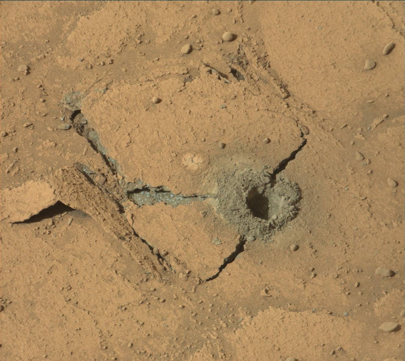
It appears from the most recent image sent back from Curiosity today of its February 25, 2023 attempt to drill into the marker layer on Mount Sharp — the fifth such attempt — the rover finally succeeded in getting deep enough to collect sufficient sample material for analysis.

That image is to the right, cropped, reduced, and sharpened to post here. Note that it is not yet confirmed from the science team that this drill attempt was deep enough. What makes this particular drilling attempt intriguing is how the many thin layers of the marker layer responded to the stress of the drill. The top layer cracked like a plate and separated from the adjacent lower layer during drilling. It apparently was hard enough to retain most of its structure, and rather than crumble the drill stresses caused a large section to break away and lift off.

The panorama above, cropped and reduced to post here, was taken the same day from this location, produced from 37 photos taken by the rover’s right navigation camera. The cropped section above looks forward at what I previously labeled “a Martian hill of pillows.” The overview map below shows the context of this panorama.
» Read more

2 comments

For the 4th time Curiosity’s drill fails to penetrate marker layer

Failed drillhole by Curiosity in marker layer
Click for original image.

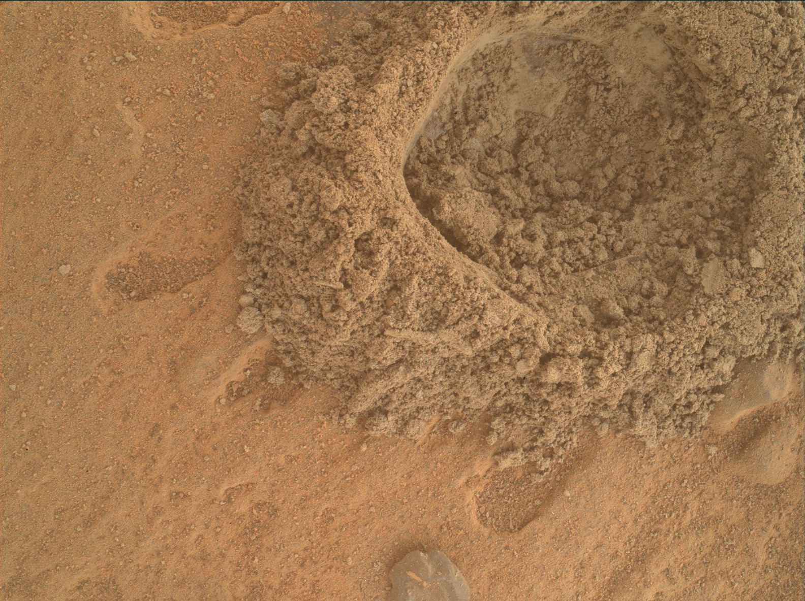
For the fourth time this past weekend Curiosity’s drill was unable to penetrate the hard rock of what scientists have labeled “the marker layer”, a distinct feature seen at approximately the same elevation at many places on the flanks of Mount Sharp on Mars.

The image to the right, cropped and reduced to post here, shows that the drill was once again only able to drill a eighth to a quarter inch, not enough to gather samples for testing.

This was our fourth attempt to drill this marker band, and we gave it our best shot from both a geology and engineering perspective. Unfortunately these rocks do not want to cooperate – they’re hard and they weather into resistant and recessive beds which make them very challenging to drill. So the team made the difficult decision to get back on the road, without a drill sample from this location

» Read more

6 comments

Curiosity takes high resolution panorama of the canyon it will soon enter

Curiosity looks into Gediz Valles
Click for original image.

Using its high resolution camera, the Curiosity science team has now released a November 2022 panorama looking south into Gediz Vallis, the Martian slot canyon that the rover will be entering in the near future.

The panorama above, cropped and reduced to post here, shows that canyon. The red dotted line indicates Curiosity’s approximate path since the panorama was taken, circling around behind Chenapua.

The mosaic is made up of 18 individual images that were stitched together after being sent to Earth. The color has been adjusted to match lighting conditions as the human eye would see them on Earth.

Not only should you definitely look at the original, at full resolution, but also compare it with the black and white mosaic I posted in December 2022, taken by the rover’s navigation camera looking in the same direction though from a slightly different position. The color definitely underlines the spectacular nature of the landscape.

7 comments

Curiosity scientists find evidence of lake water higher on Mount Sharp than expected

Panorama as of January 17, 2023
Curiosity’s view of the marker band on January 17, 2023, the red dotted line the planned future route. Click for full image.

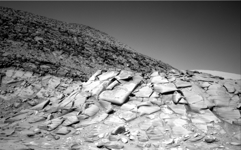
The science team for the Mars rover Curiosity today revealed that the marker band layer where the rover present sits shows some of the best evidence of liquid water and waves yet seen on Mount Sharp, and it has been found much higher on the mountain than expected.

Having climbed nearly a half-mile above the mountain’s base, Curiosity has found these rippled rock textures preserved in what’s nicknamed the “Marker Band” – a thin layer of dark rock that stands out from the rest of Mount Sharp. This rock layer is so hard that Curiosity hasn’t been able to drill a sample from it despite several attempts. It’s not the first time Mars has been unwilling to share a sample: Lower down the mountain, on “Vera Rubin Ridge,” Curiosity had to try three times before finding a spot soft enough to drill.

Scientists will be looking for softer rock in the week ahead.

As Curiosity climbs the mountain it transitions onto new younger layers of rock. Based on Curiosity’s earlier data lower down the mountain, scientists had assumed it had gone from layers that had been under a past lake to layers that were at the lake’s shoreline to layers where only running water once flowed. They had thought the marker layer and other higher layers would only show evidence of running water. Instead, in the marker layer they have once again found evidence of an ancient lake.
This quote by Ashwin Vasavada, Curiosity’s project scientist, sums things up nicely: “Mars’ ancient climate had a wonderful complexity to it, much like Earth’s.”

0 comments

Curiosity spots foot-wide meteorite on Mars

Meteorite on Mars?
Click for original image.

Curiosity appears to have identified a foot-wide rock on the surface of Mars that is likely a meteorite.

While the JPL press release at this link is certain this is a meteorite, the Curiosity science team is properly more circumspect:

The rock we are parked in front of is one of several very dark-colored blocks in this area which seem to have come from elsewhere, and we are calling “foreign stones.” Our investigations will help determine if this is a block from elsewhere on Mars that just has been weathered in an interesting way or if it is a meteorite.

The image to the right surely does look like a meteorite. If so, this would be one of the largest found so far on Mars by any rover.

3 comments
1 2 3 4 5 6 13