The vanishing volcanoes of Ceres

New research based on Dawn data suggests that volcanoes on Ceres flatten and disappear over time.

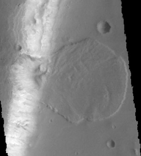
NASA’s Dawn spacecraft discovered Ceres’s 4-kilometer (2.5-mile) tall Ahuna Mons cryovolcano in 2015. Other icy worlds in our solar system, like Pluto, Europa, Triton, Charon and Titan, may also have cryovolcanoes, but Ahuna Mons is conspicuously alone on Ceres. The dwarf planet, with an orbit between Mars and Jupiter, also lies far closer to the sun than other planetary bodies where cryovolcanoes have been found.

Now, scientists show there may have been cryovolcanoes other than Ahuna Mons on Ceres millions or billions of years ago, but these cryovolcanoes may have flattened out over time and become indistinguishable from the planet’s surface. They report their findings in a new paper accepted for publication in Geophysical Research Letters, a journal of the American Geophysical Union. “We think we have a very good case that there have been lots of cryovolcanoes on Ceres but they have deformed,” said Michael Sori of the Lunar and Planetary Laboratory at the University of Arizona in Tucson, and lead author of the new paper.

The cause of the flattening?

Viscous relaxation is the idea that just about any solid will flow, given enough time. For example, a cold block of honey appears to be solid. But if given enough time, the block will flatten out until there is no sign left of the original block structure. On Earth, viscous relaxation is what makes glaciers flow, Sori explained. The process doesn’t affect volcanoes on Earth because they are made of rock, but Ceres’s volcanoes contain ice – making viscous relaxation possible.

0 comments

USGS responds to Congressional inquiry about data tampering with blank documents

Why we got Trump: In response to a demand for documents from a Congressional investigation into data manipulation that the US Geological Survey allowed two chemists to do for nearly two decades, the USGS turned over documents with almost all the pages blank.

“Are we supposed to play tic-tac-toe on this?” Gohmert asked Tuesday, while waving one of the documents during a hearing of the House Natural Resources Subcommittee on Oversight and Investigations on the data manipulation. The USGS lab where two chemists skewed data for nearly two decades was finally closed in March 2016.

Gohmert’s subcommittee had requested the documents in September. The blanks received Tuesday represented only a small portion of the total sought by the panel. “We’re still waiting for documents we requested three months ago,” Gohmert said. “Some of the documents we did receive were redacted, they were duplicates or were even blank pages.”

Meanwhile, the USGS refuses to name the two chemists or describe how they were punished. For all we know, they still work there. And it is important to note, that the data manipulation took place in connection with “various energy-related topics, including coal reserves and uranium deposits.” Want to bet the manipulation was done to discourage development?

1 comment

Curiosity finds a meteorite

The Curiosity science team have identified and now analyzed a nickel-iron meteorite that Curiosity spotted on October 27.

Scientists of the Mars Science Laboratory (MSL) project, which operates the rover, first noticed the odd-looking rock in images taken by Curiosity’s Mast Camera (Mastcam) at at a site the rover reached by an Oct. 27 drive. “The dark, smooth and lustrous aspect of this target, and its sort of spherical shape attracted the attention of some MSL scientists when we received the Mastcam images at the new location,” said ChemCam team member Pierre-Yves Meslin, at the Research Institute in Astrophysics and Planetology (IRAP), of France’s National Center for Scientific Research (CNRS) and the University of Toulouse, France.

ChemCam found iron, nickel and phosphorus, plus lesser ingredients, in concentrations still being determined through analysis of the spectrum of light produced from dozens of laser pulses at nine spots on the object. The enrichment in both nickel and phosphorus at some of the same points suggests the presence of an iron-nickel-phosphide mineral that is rare except in iron-nickel meteorites, Meslin said.

The find is not unprecedented but it is interesting nonetheless.

2 comments

Comet 67P/C-G slowly breaking apart

A comparison of Rosetta images before and after Comet 67P/C-G’s close approach to the sun last year found new fractures and an enlargement of older fractures.

The fractures appear to be developing as forces subtly bend the comet to and fro, Stubbe Hviid, a planetary scientist at the German Aerospace Center Institute of Planetary Research in Berlin, reported October 17 in a press conference at a meeting of the American Astronomical Society’s Division for Planetary Sciences. Hviid and colleagues combined maps from Rosetta with computer simulations of all the forces at work within the comet to determine how the cracks develop. They found that the two bulbous ends rock in opposite directions as the comet spins, flexing the neck and creating severe stress. Because the comet isn’t held together strongly — it’s a conglomeration of dust and ice not much stickier than snow, Hviid said — the neck is starting to break. After a few hundred more years, he said, the comet could fold itself in half as the two lobes snap apart and smoosh together.

0 comments

Active volcano on Venus?

The uncertainty of science: A new analysis of past data from a variety of Venus orbiters suggests that at least one volcano is active there.

The review of old data from the Magellan and Venus Express orbiters suggests that some lava flows on the volcano’s slopes are fresh, though how fresh remains unknown. However, computer models and the detection of excess heat by Venus Express on the mountain’s eastern slopes adds weight to the theory that the volcano is spewing out lava.

0 comments

An ancient volcanic mountain chain on Mars

Using data from Mars Odyssey scientists have determined that a mountain chain on Mars was likely created as a chain of volcanoes.

They analyzed the geography and mineralogy of this area they termed Greater Thaumasia, which is about the size of North America. They also studied the chemistry of this area based on Gamma Ray Spectrometer data collected by the Mars Odyssey Orbiter, which was launched in 2001. What they found was the mountain ridge that outlines Greater Thaumasia was most likely created by a chain of volcanoes.

Their research also looked to see if water influenced the mountains’ formation and found no evidence for it. The mountain chain itself is south of the giant Valles Marineris canyons and southeast of the Tharsis region where Mars’ biggest four volcanoes are located.

0 comments

Mars’ weird windblown surface

Wind scoured Martian surface

Cool image time! The image on the right, taken by Mars Reconnaissance Orbiter (MRO) and cropped from a wider view of a small crater and a small volcano caldera, certainly appears blurred and out of focus. Is MRO malfunctioning?

Nope. The blurring is actually an optical illusion caused almost entirely by our own assumptions of what a planet surface should look like combined with the alien processes occurring on Mars that have no equivalent here on Earth.

Below the fold is a wider view from the full image, showing the area of the cropped image to the right as well as the entire crater. Below that is another full resolution inset, this time showing the features on the crater rim that are sharp and stand out clearly. The blurriness of the rest of the image is not because the image is out-of-focus, but because a steady northwest-to- southeast wind has distorted everything in the same direction.
» Read more

3 comments

An avalanche pile on Mars

Avalanche pile on Mars

Cool image time! The Mars Odyssey science team has released this very interesting image, cropped on the right, of an avalanche debris pile formed when the large section of cliff on the left broke off and collapsed into the valley below. The valley is called Tiu Valles and is located close to Mars’ equator.

The wide spread of the debris is an indication of several things. For one, it illustrates the light Martian gravity, which allowed the debris to flow much farther than it would have on Earth.

For another, the spread of the debris pile suggests to me that the material that fell was very crumbly. It might have been able to hold together as a cliff for a long time, but when it collapsed the material broke apart almost like sand. Think of a sand castle you might have built as a kid on the beach. With a little moisture you can pack the sand to form solid shapes, but if your shape breaks apart the sand falls not as large blocks but as crumbly soft and loose sand. That is what appears to have happened here.

There is also the suggestion to me that water might have been involved somehow in this collapse. I am not a geologist so this speculation on my part is very unreliable. However, the shape of the debris pile suggests a liquid flow. The flow itself wasn’t liquid, but liquid might have somehow been involved in causing this geological event. We would need a geologist however to clarify these guesses on my part.

3 comments

Statistical analysis suggests Moon can cause quakes

The uncertainty of science: A careful statistical analysis of when major earthquakes occur has suggested they are more likely to be more powerful if they occur around the full and new moons when tidal forces are at their peak.

Satoshi Ide, a seismologist at the University of Tokyo, and his colleagues investigated three separate earthquake records covering Japan, California and the entire globe. For the 15 days leading up to each quake, the scientists assigned a number representing the relative tidal stress on that day, with 15 representing the highest. They found that large quakes such as those that hit Chile and Tohoku-Oki occurred near the time of maximum tidal strain — or during new and full moons when the Sun, Moon and Earth align.

For more than 10,000 earthquakes of around magnitude 5.5, the researchers found, an earthquake that began during a time of high tidal stress was more likely to grow to magnitude 8 or above.

As these results are based entirely on statistical evidence, not on any direct link between tidal forces and actual quakes, they are quite uncertain and unproven.

5 comments

The alien buttes of Mars

Weird Mars

The image above is cropped from a panorama created by reader Phil Veerkamp from images taken by Curiosity’s mast camera on August 25, 2016 of the terrain that partly surrounds the rover since it passed the Balanced Rock and traveled beyond Murray Buttes

The full image is too large to post here. However, if you click on the first link above you can either download it and peruse it at your leisure, or view it with your browser. You will definitely want to do so, as it is high resolution and shows a lot of strange and alien geology, including multiple slabs seemingly hanging in space because of the low gravity. (Hint: Be sure to pan all the way to the right!) On the image’s left Mount Sharp can be seen raising in the background. Below the fold I have annotated the most recent Mars Reconnaissance Orbiter image of Curiosity’s location to indicate what I think is the area included in this panorama. This MRO image also shows that once Curiosity gets through the narrow gap to the south, the path heading south up the mountain’s slopes will, for awhile at least, be relatively open with few large obstacles. The view will also change, as the rover will be out of the region of buttes.
» Read more

6 comments

Fossilized rivers on Mars

The uncertainty of science: Using high resolution images from Mars Reconnaissance Orbiter scientists have identified more than 10,000 miles of fossilized rivers on Mars.

The new study examined images covering an area roughly the size of Brazil at a much higher resolution than was previously possible – six metres per pixel compared to 100 metres per pixel. While a few valleys were identified, the team revealed the existence of many systems of fossilised riverbeds which are visible as inverted channels spread across the Arabia Terra plain.

The inverted channels are similar to those found elsewhere on Mars and Earth. They are made of sand and gravel deposited by a river and when the river becomes dry, the channels are left upstanding as the surrounding material erodes. On Earth, inverted channels often occur in dry, desert environments like Oman, Egypt, or Utah, where erosion rates are low – in most other environments, the channels are worn away before they can become inverted. “The networks of inverted channels in Arabia Terra are about 30m high and up to 1–2km wide, so we think they are probably the remains of giant rivers that flowed billions of years ago. Arabia Terra was essentially one massive flood plain bordering the highlands and lowlands of Mars. We think the rivers were active 3.9–3.7 billion years ago, but gradually dried up before being rapidly buried and protected for billions of years, potentially preserving any ancient biological material that might have been present,” added Joel Davis.

These geological forms are different than most of the more well-known Martian channels in that they are not channels but meandering riverlike ridges, higher than the surrounding terrain. Arabia Terra, where they are located, is a transition region in the northern mid-latitudes between Mars’s southern highlands and its northern flat plains, where some believe an ocean once existed.

2 comments
1 130 131 132 133 134 157