Mars’s giant tsunamis

New research using data from a variety of Mars orbiters suggests that large tsunamis previously smashed against the shores of the red planet, shaping the geography.

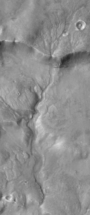
The group zeroed in on a region on Mars where the highlands known as Arabia Terra bump up against the lowlands of Chryse Planitia — a place where the waters of an ancient ocean might have lapped at the shoreline. Using imagery from several Mars-orbiting spacecraft, Rodriguez’s group identified two particular geological formations that they say formed during two different tsunamis. The first, older formation looks as if an enormous wave had rushed up onto the edge of the highlands, dropping boulders as big as 10 metres across. The water then drained back down into the ocean, leaving channels cut through the freshly deposited debris.

Then, millions of years passed. Temperatures dropped and glaciers crept across the landscape, scouring deep valleys. Finally, a second impact-generated tsunami came rushing again towards the shore. “But this time it is different,” Rodriguez says. Because the climate was so much colder, the tsunami moved over the landscape like an icy slurry. It froze before it had a chance to wash back into the ocean, leaving dense lobes of frozen debris on the ground.

They propose the waves were caused by large meteorite impacts. They also admit that there are large uncertainties in their theory and conclusions.

1 comment

Increased earthquake activity at Mount St. Helens

Though the increase is not large enough to indicate the likelihood of another eruption, scientists have noted that for the past eight weeks the earthquake rates under Mount St. Helens has been increasing.

Over the last 8 weeks, there have been over 130 earthquakes formally located by the Pacific Northwest Seismic Network and many more earthquakes too small to be located. The earthquakes have low magnitudes of 0.5 or less; the largest a magnitude 1.3. Earthquake rates have been steadily increasing since March, reaching nearly 40 located earthquakes per week. These earthquakes are too small to be felt at the surface.

Once again, these quakes do yet not signal another eruption. They are more likely signs of the mountain’s continuing but long and slow adjustment back to silence after the 1980 eruption. Nonetheless, they bear watching, as a volcano will do what a volcano wants to do.

1 comment

Ice and volcanoes on ancient Mars?

New data of past volcanic activity on Mars suggest that the red planet was once covered by at least one extensive ice sheet.

There is a great deal of uncertainty in this conclusion, however. They have found one example with the right geology to suggest past ice sheets under which volcanoes erupted. Translating this into an extensive ice sheet requires many assumptions that might not prove true with further research.

1 comment

Halo craters on Pluto

More images from New Horizons reveal even more strange terrain on Pluto.

Data suggest that the bright rims are made of methane ice, while the dark crater floors are made of water ice, though why this has happened is a complete mystery. As they note at the link above, “Exactly why the bright methane ice settles on these crater rims and walls is a mystery; also puzzling is why this same effect doesn’t occur broadly across Pluto.”

0 comments

Evidence of water on Ceres?

water on Ceres?

New data from Dawn suggests that there is significant water locked in surface of Ceres’s north polar regions.

These data reflect the concentration of hydrogen in the upper yard (or meter) of regolith, the loose surface material on Ceres. The color information is based on the number of neutrons detected per second by GRaND. Counts decrease with increasing hydrogen concentration. The color scale of the map is from blue (lowest neutron count) to red (highest neutron count). Lower neutron counts near the pole suggest the presence of water ice within about a yard (meter) of the surface at high latitudes.

Note that the data has not detected water. The blue areas on the image to the right suggest an increased amount of hydrogen, which could only be held to the surface if it was locked in some molecule, with water being the most likely candidate. Like the Moon, until we actual capture some samples, it will be difficult to confirm with certainty the presence of water.

0 comments

Vast Martian dune fields

Olympia Undae dune field

Cool image time! In the past few days the Themis camera on Mars Odyssey has taken two pictures of the vast Olympia Undae dune field near Mars’s north pole. The image to the right is only a cropped, lower resolution section of one of those images.

The image was taken during the summer, so most of the winter CO2 frost has sublimated away. Unfortunately, the website does not provide a scale, though they say the full images each cover about 12 by 43 miles of territory. Yet, both images capture only very tiny portions of the dune field, which apparently goes on and on for many hundreds of miles in all directions, looking exactly the same wherever you look.

Just imagine trying to travel though this area. It is the epitome of a trackless waste. And without some form of GPS system getting lost forever would be incredibly easy.

1 comment

New close-up of Occator Crater’s spots

Occator Crater central spot

The Dawn science team have released new images taken from the spacecraft’s low orbit observations, including a close-up of the central white spot at Occator Crater, the brightest spot on Ceres.

The image on the right is a cropped though full resolution version of the full image. I have reduced it only slightly. As they note,

Occator Crater, measuring 57 miles (92 kilometers) across and 2.5 miles (4 kilometers) deep, contains the brightest area on Ceres, the dwarf planet that Dawn has explored since early 2015. The latest images, taken from 240 miles (385 kilometers) above the surface of Ceres, reveal a dome in a smooth-walled pit in the bright center of the crater. Numerous linear features and fractures crisscross the top and flanks of this dome. Prominent fractures also surround the dome and run through smaller, bright regions found within the crater.

1 comment

A new gravity map of Mars

Using data from three orbiting NASA spacecraft scientists have created a new gravity map of Mars, showing the subtle variations in its gravitational field due to density differences within the planet.

The improved resolution of the new gravity map suggests a new explanation for how some features formed across the boundary that divides the relatively smooth northern lowlands from heavily cratered southern highlands. Also, the team confirmed that Mars has a liquid outer core of molten rock by analyzing tides in the Martian crust and mantle caused by the gravitational pull of the sun and the two moons of Mars. Finally, by observing how Mars’ gravity changed over 11 years – the period of an entire cycle of solar activity — the team inferred the massive amount of carbon dioxide that freezes out of the atmosphere onto a Martian polar ice cap when it experiences winter. They also observed how that mass moves between the south pole and the north pole with the change of season in each hemisphere.

1 comment

The first geology map of Pluto

Geology map of Pluto

The New Horizons science team has now released the first geology map of a portion of Pluto, seen by the spacecraft during its fly-by last year.

It is definitely worth your while to take a look at the full image, along with the legend explaining the different surface features. Most of the geological terms are merely descriptive, but the careful breakdown still provides a much deeper understanding of what is there.

1 comment

A river on Mars

A river on Mars

Cool image time! The science team for the high resolution camera on Mars Reconnaissance Orbiter this week released it monthly set of cool images. One of those images, which I have cropped and reduced to show it here, is of an ancient river on Mars, the formation process of which geologists still debate. As the scientists note,

The channel pattern, called “dendritic” because of its tree–like branching, begins at the top of the image and runs down over the rim of an ancient impact basin across the basin floor. The soil surface overlying these channels, and indeed the entire landscape, has been changed and reworked over the intervening millions of years, by the combined actions of wind and ice. Over time, the original channels become muted or even erased.

One thing I learned in writing an article for Astronomy about the rivers seen on Saturn’s moon Titan is that without plant life there is no known natural process to hold river banks in place. Instead, if the grade is shallow and not confined by bedrock cliffs, rivers will meander about randomly forming braided channels as there will be nothing on shore to hold the water within the same course. For example, on a lifeless Earth the water draining the central basin of the midwest United States would have flowed south across a wide scattered area covering the entire plains, rather than flowing within the courses of the Missouri and Mississippi rivers.

Thus, it is not surprising that this river on Mars appears muted or partly erased. It probably was never very clearly delineated in the first place.

1 comment
1 132 133 134 135 136 157