Perseverance as seen from orbit

Perseverance as seen from orbit
Click for full image.

Overview map
Click for interactive map.

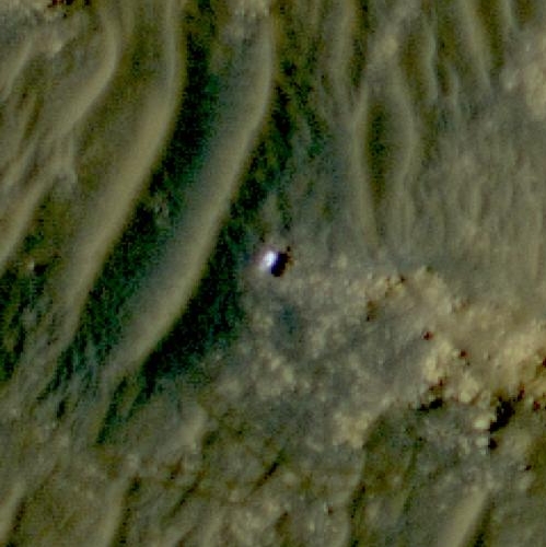
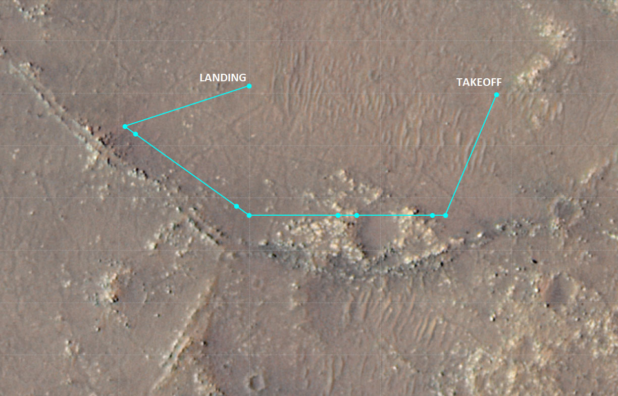
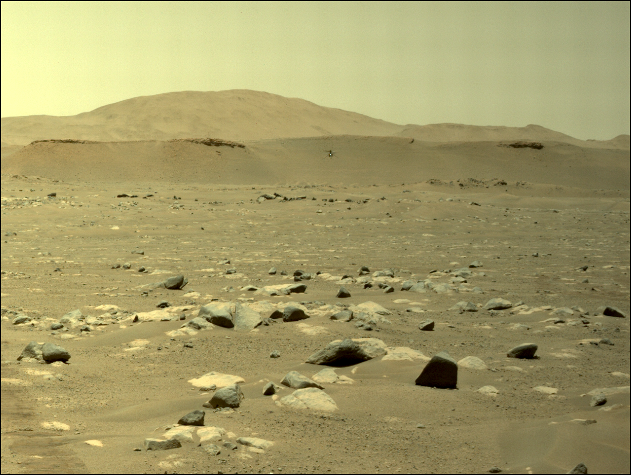
The science team for the high resolution camera on Mars Reconnaissance Orbiter (MRO) have snapped a picture of Perseverance at its present location in Jezero Crater.

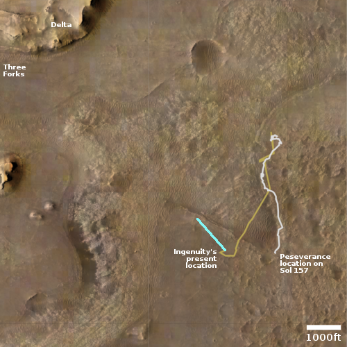
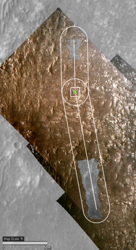
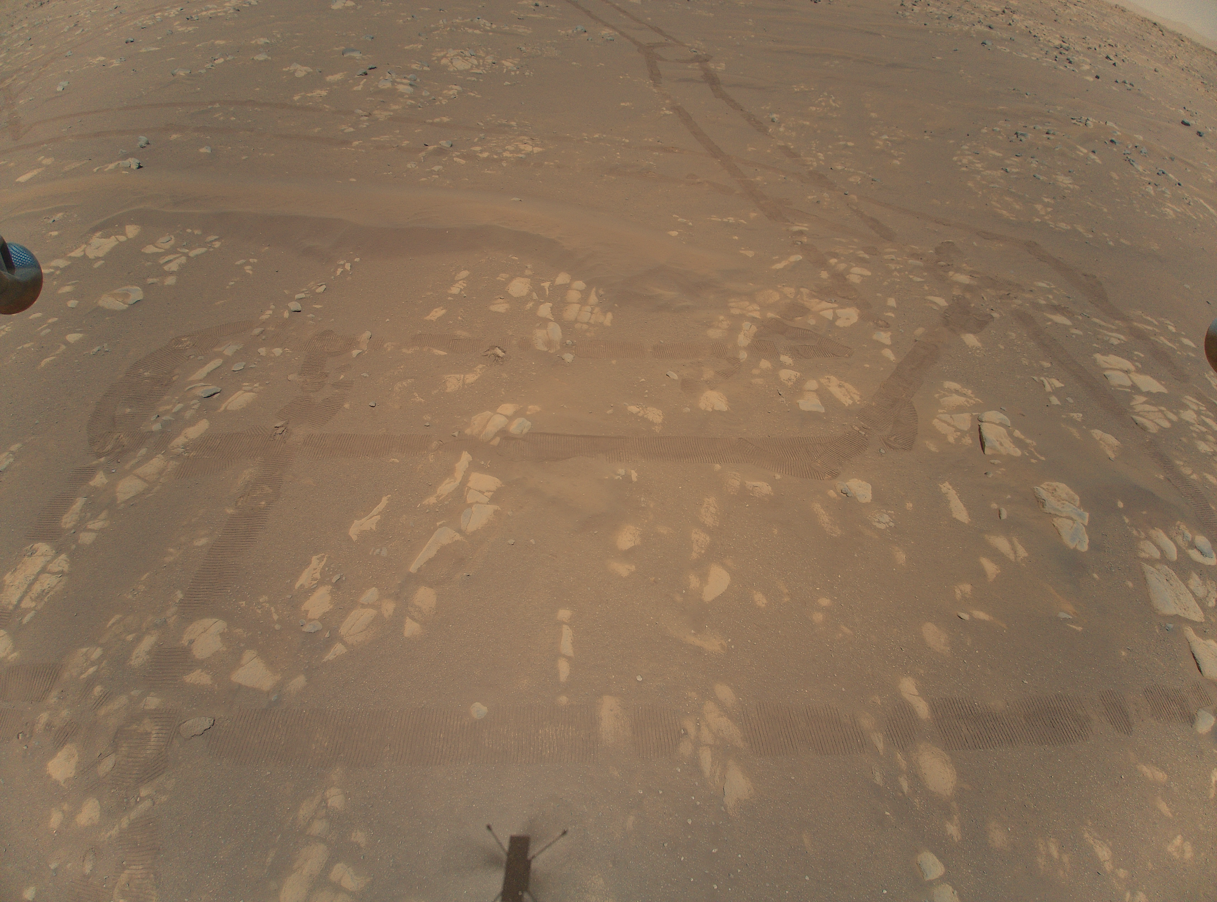
The first image to the right, cropped to post here, shows the rover as a white dot to the right of the two long sand dunes. If you look close image, you can see the rover’s tracks near the bottom of the image.

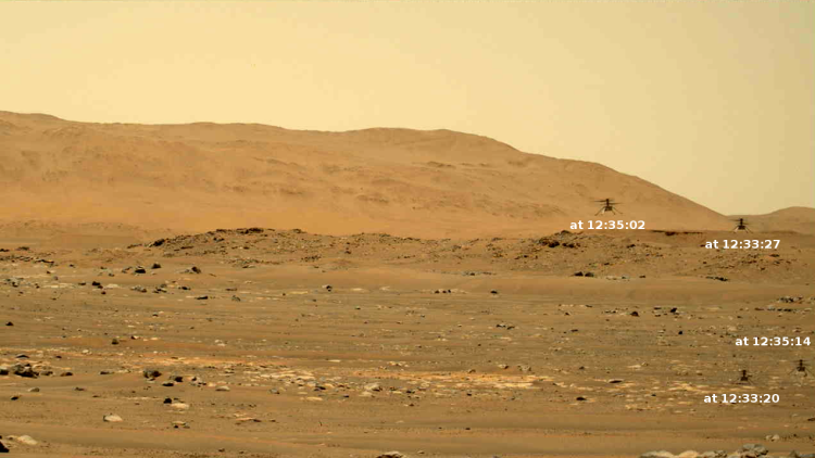
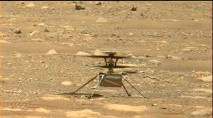
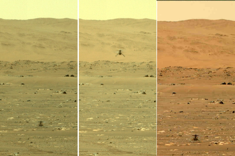
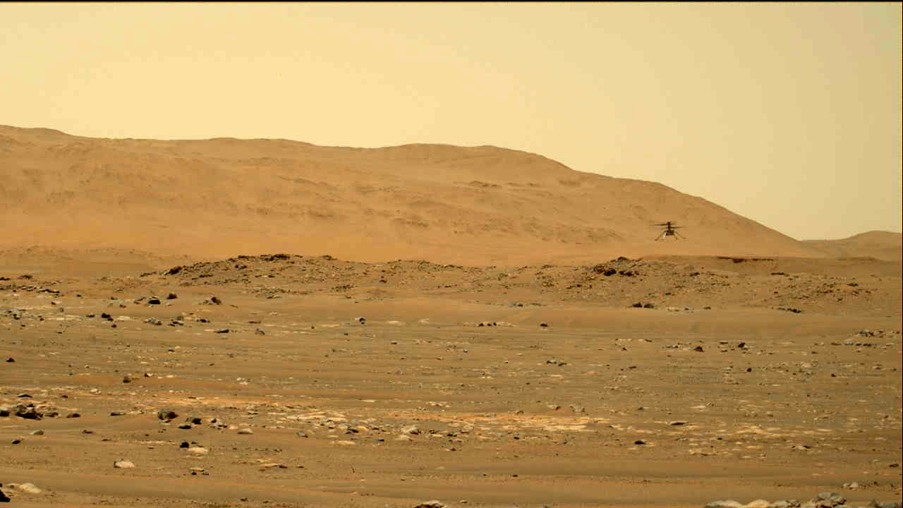
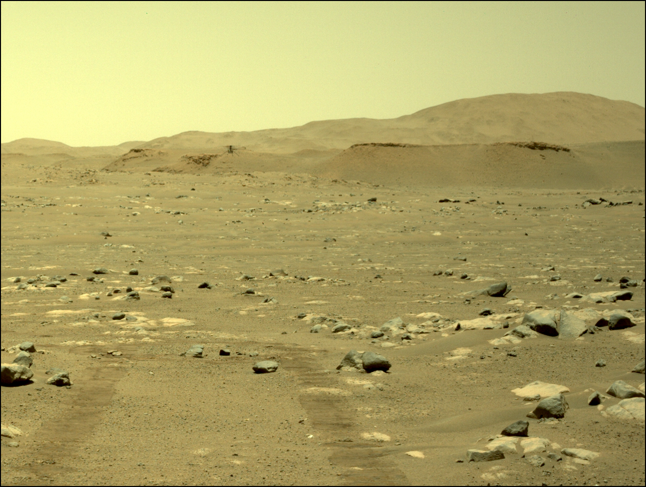
Ingenuity is likely also in the full image, but is likely too small for MRO’s high resolution camera to pick out.

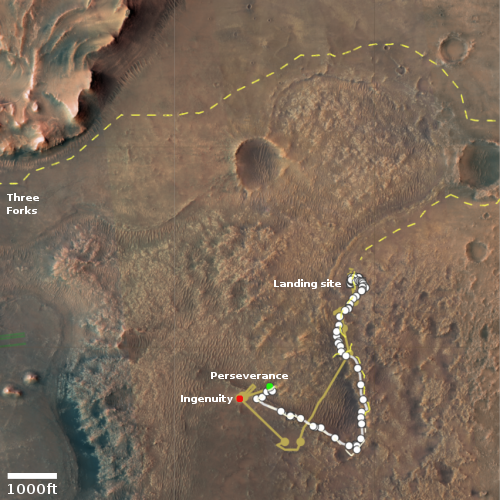
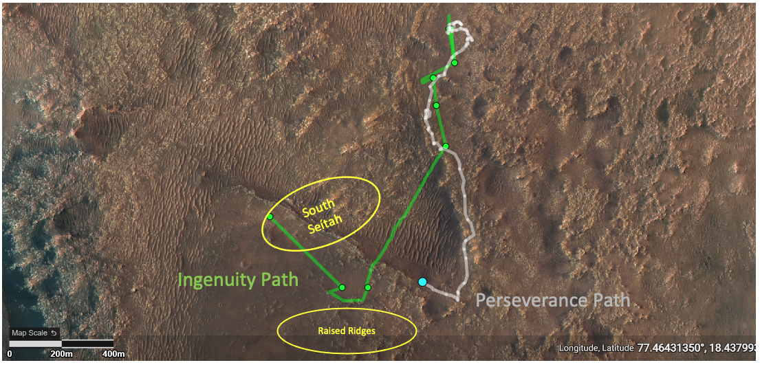
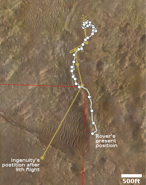
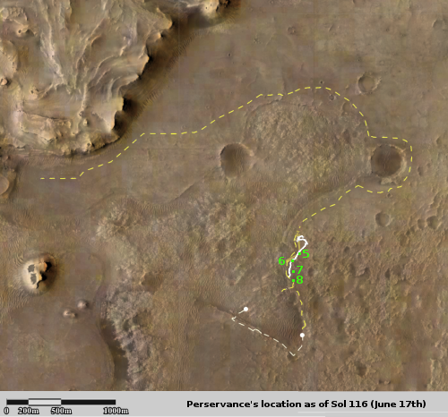
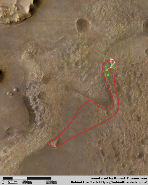
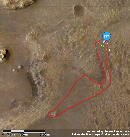
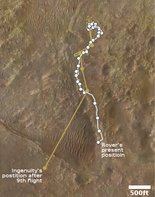
The second image is a overview map. The green dot marks the rover’s position, with the red dot Ingenuity’s present position. The dotted white line shows the route the rover has taken so far. The light brown line indicates the flight paths for all of Ingenuity’s flights. The yellow dotted line indicates the future planned route of Perseverance.

With Mars about to slip behind the Sun, communications with both rovers, Perseverance and Curiosity, as well as all the orbiters, will shortly go silent for about two weeks.

When that pause ends, the question will be where Perseverance goes next. The original plan was to retreat back along its previous path, going to the southeast before heading north past the landing site. I strongly suspect that they will instead head directly to the landing site, going to the northeast across the rough terrain, both to see something new as well as further test the rover’s ability to travel tougher ground.

They avoided that area initially because they were still in the rover’s check out period. Now that they know it works, there is no reason to avoid that ground, especially because it will be ground they have not viewed before. They could even use Ingenuity to scout it out more thoroughly.

Ingenuity completes 13th flight

Ingenuity landing on September 5, 2021
Click for full image.

Though the full slate of images taken has not yet been released, it appears from the five images available that the thirteenth flight of Ingenuity on September 5, 2021 ended successfully. The photo to the right is the last available, and shows the helicopter’s shadow on the ground mere seconds before touch down. The landing legs’ shadows suggest it is oriented properly for that landing.

No word yet on how successful the flight itself was. The goal had been to fly back over the South Seitah area from a different angle and lower altitude, getting different perspectives of the ridges there to help plan Perseverance’s coming travels across that terrain.

The second picture below, cropped, reduced, and enhanced to post here, was taken about forty minutes before take-off by Perseverance and captures Ingenuity in the lower left, as indicated by the arrow.
» Read more

China building Ingenuity copycat

Ingenuity vs China

China’s space program revealed yesterday that it is designing its own Mars helicopter for future missions to the Red Planet.

The picture to the right shows this Chinese helicopter prototype on the bottom, with Ingenuity on Mars on top.

Notice the similarity? In fact, one could almost say that the Chinese helicopter is an outright steal of the JPL design.

But then, why not? According to an 2019 inspector general report [pdf], China hacked into JPL’s computers twice from 2009 to 2017 and stole 500MB of data. That data almost certainly included the design plans for Ingenuity, under development at the time.

Copying the work of others is expected, especially when that design is found to work. In this case however it almost certainly isn’t copying, but outright theft.

Of course, that has been par for the course for China’s space program. They don’t appear to be capable of innovating on their own. They first must steal someone else’s design, and then revise and upgrade from that. Their final products might be of high quality, but in the end their long term ability to build something new is going to be severely limited, if they cannot start inventing things on their own.

Perseverance’s upcoming targets: sand ripples, rocks, and a lot of dust

Ingenuity's view during 12th flight

Cool image time! The photo to the right was one of ten color images taken by Ingenuity on its twelfth flight on August 15, 2021. This photo is one of two images looking the same area from slightly different positions in order to create a stereoscopic view, with the other image found here.

The ground the helicopter was scouting, dubbed South Seitah, is an area that the Perseverance team hopes to send the rover. Ingenuity’s images from this flight will not only tell them whether the terrain is safe to traverse, it will allow them to map out a route that will avoid problems while effectively targeting the most interesting rocks.

The photo shows a lot of Martian dust, with a good portion forming small sand dune ripples. The rocks appear to be bedrock pavement stones, which because these are on the floor of the crater and the lowest elevation, likely hold the oldest geology that Perseverance will see on its journey in Jezero Crater. For this reason the science team is spending a lot of time studying that floor, and will make probably several drilling attempts to obtain samples.

The terrain in general looks entirely safe for the rover to travel. I expect the science team will thus continue north, crossing to North Seitah, rather than backtrack and travel over already traversed ground. Initially they had decided to avoid this ground because they feared it might be too rough for the rover. I suspect they were just being overly cautious at the start of the mission, and will now work past that fear.

Ingenuity’s 12th flight successful

Ingenuity's shadow just before landing.

According to the Perseverance science team, the Mars helicopter Ingenuity successfully completed its twelfth flight on Mars early yesterday, making a short scouting round trip over an area called South Seitah to provide images that the team can use to plan the rover’s future route.

All told, Ingenuity flew just under 1,500 feet flying about 30 feet above the ground for just under three minutes. The picture to the right was taken just before landing, and shows the helicopter’s shadow on the ground. It is one of six so far downloaded. The remaining images will follow later.

The announcement was made on Twitter, and included some embarrassingly over-the-top prose:

The #MarsHelicopter’s latest flight took us to the geological wonder that is the “South Séítah” region.

South Seitah is hardly a “geological wonder”. It is a sandy area with some rocks and interesting geology.

I’m not sure why, but the Perseverance rover team seems prone to do this with their press releases and announcements. The claim they make over and over that Perseverance’s prime mission is to look for ancient life is junk Now they call a relatively undistinguished and small area on a crater floor a “wonder.”

Makes one think they somehow feel a need to justify what they are doing, something that is patently absurd. They are controlling a robotic rover and helicopter tens of millions of miles away as both explore a place on another planet no one had ever visited before. That certainly is spectacular enough, and does not need purple prose to justify.

Ingenuity’s next flight

Ingenuity's flight plane for 12th flight
Click for full image.

The Ingenuity engineering team today announced their plans for the helicopter’s twelfth flight on Mars, scheduled for early tomorrow.

Ingenuity will climb to an altitude of 10 meters and fly approximately 235 meters east-northeast toward the area of interest in Séítah. Once there, the helicopter will make a 5-meter “sidestep” in order to get side-by-side images of the surface terrain suitable to construct a stereo, or 3D, image. Then, while keeping the camera in the same direction, Ingenuity will backtrack, returning to the same area from where it took off. Over the course of the flight, Ingenuity will capture 10 color images that we hope will help the Perseverance science team determine which of all the boulders, rocky outcrops and other geologic features in South Séítah may be worthy of further scrutiny by the rover.

The map above shows South Seitah in the yellow oval. The yellow line marks Ingenuity’s past flights. The white line marks the path Perseverance has taken south since landing. The dashed lines mark Perseverance’s planned route.

Thus, the helicopter will be obtaining aerial photos of the region in Seitah where the scientists want to send Perseverance, in order to help them pick the best route.

Ingenuity successfully completes 11th flight

Ingenuity about to land
Click for full image.

Ingenuity has successfully completed its 11th flight, safely touching down at approximately its planned landing spot. From the science team’s tweet:

[Ingenuity] has safely flown to a new location! Ingenuity flew for 130.9 seconds and traveled about 380 meters before landing.

The image to the right, reduced to post here, was taken mere seconds before landing, and shows the helicopter’s shadow directly below it on the ground.

This particular flight was the first that did not push Ingenuity’s abilities, merely flying in a straight line to put it in a good position for later flights and to keep it ahead of Perseverance.

So far they have only released five images from the flight. Expect the rest to be downloaded from Perseverance in the next few days.

Ingenuity’s 11th flight scheduled for tonight

Ingenuity's 11th flight plan
Click for interactive map.

The next flight of Ingenuity on Mars is now scheduled for this evening, and will be a much simpler flight than the helicopter’s previous trip.

The map to the right shows the route in blue. The flight is mainly a transfer flight, intended to keep the copter ahead of the rover as they leapfrog from point to point in Jezero Crater. It will actually be the first flight by Ingenuity that does not push its engineering in any major way.

This map, the most up-to-date available, is at this moment about five sols out of date. Perseverance is likely slightly south and to the west of the location shown.

The present plan is for Perseverance to travel to the northwest along the dark ridgeline that Ingenuity will land next to. The rover will then retreat, returning more or less to its landing area and then north to circle around the largest crater on the map and then to head west to the base of the delta to the area labeled “Three Forks”, which is their entrance to the delta’s geology.

The view of Jezero Crater, from both Ingenuity and Perseverance

The view from Ingenuity during 10th flight
Click for full image.

Cool image time! Today the Perseverance science team released the 200 images that Ingeniuty took during its 10th flight on July 24, 2021.

The photo to the right was taken about 25 seconds before the helicopter landed, and looks to the southwest. In the foreground can be seen the ridge of rocks and pebbles that the scientists sent Ingeniuty to photograph. In the distance can be seen the rim of Jezero Crater, about 7.5 miles away, with some rounded hills that sit in the crater floor about 5.5 miles away.

The white box indicates the area covered by two high resolution images taken by Perseverance on July 28th that I have combined into the panorama below.
» Read more

Update on Ingenuity’s 10th flight and Perseverance’s first sample drilling

Ingenuity landing at end of 10th flight

The news coming from the Perseverance and Ingeniuty science teams has been sparse this past weekend, even though Perseverance had begun drilling its first core sample that it will stored for pickup by a later unmanned robot, and Ingenuity had attempted its 10th and most challenging flight yet.

We do have images however, and the two to the right give us hints about what has happened.

First, the top picture on the right was taken by Ingenuity’s navigation camera just prior to landing. The camera looks straight down and is used by the helicopter to adjust its flight. The dark area is the helicopter’s shadow. Based on this picture and the four preceding images (taken over an eleven second period), it appears the helicopter was landing safely. No other images have yet been downloaded, nor has the Ingenuity team announced any results, so we do not yet know if the flight proceeded as planned.

UPDATE: The flight was a success, as per this JPL announcement:

With the #MarsHelicopter’s #flight success today, we crossed its 1-mile total distance flown to date. It targeted an area called “Raised Ridges,” named for its #geographic features. Flight 10 is #Ingenuity’s most complex flight profile yet, with 10 distinct waypoints and a new #record height of 40 feet (12 meters).

Drill and core sample in the ground

The second image, taken by Perseverance’s left navigation camera and cropped and reduced to post here, is more puzzling. It shows what appears to be the core sample still in the ground after drilling. While this could be entirely as planned, it seems very surprising. Most of what I can find online describing the operation for obtaining these samples implies that the robot arm would drill the hole, and then retract the sample immediately to place it in storage. Nothing suggests the arm would be retracted with the sample still in the ground.

I think however the odds of this picture revealing a problem are low. This JPL press release from February 2021 implies vaguely that the core sample will be released in this manner before retraction. After the core sample, with bit, is separated from the arm, the release suggests they will lift the arm away to inspect the drilling process, then return the arm to retract the core sample for storage. This does make some sense, though grabbing that sample again will be quite challenging.

If this was not supposed to happen as described, then there is a problem that must be resolved. I expect more details in the next day or so to clarify this situation.

Ingenuity’s next flight set for today

Flight plan for Ingenuity's 10th flight
Click for full image.

Though circumstances can obviously change, the Ingenuity/Perseverance science teams have scheduled Ingenuity’s 10th Martian flight for sometime later today, with a flight plan, shown to the right, that is even more ambitious.

Flight 10 will allow us to reap the benefits of our previous flight. Scheduled for no earlier than this Saturday (July 24), Flight 10 will target an area called the “Raised Ridges” (RR), named for the geographic features that start approximately 164 feet (50 meters) south-by-southwest of our current location. We will be imaging Raised Ridges because it’s an area that Perseverance scientists find intriguing and are considering visiting sometime in the future.

From navigation and performance perspectives, Flight 10 will be our most complex flight to date, with 10 distinct waypoints and a nominal altitude of 40 feet (12 meters). It begins with Ingenuity taking off from its sixth airfield and climbing to the new record height. It will then head south-by-southwest about 165 feet (50 meters), where upon hitting our second waypoint, take our first Return to Earth (RTE) camera image of the Raised Ridges, looking south. Next, we’ll translate sideways to waypoint 3 and take our next RTE image – again looking south at Raised Ridges.

Imagery experts at JPL hope to combine the overlapping data from these two images to generate one stereo image. Flying farther to the west, we’ll try for another stereo pair of images (waypoints 4 and 5), then head northwest for two more sets of stereo pairs at waypoints 6 and 7 as well as 8 and 9. Then, Ingenuity will turn northeast, landing at its seventh airfield – about 310 feet (95 meters) west of airfield 6. Total time in the air is expected to be about 165 second.

Unlike the previous flights, this one will involve several turns while in the air. The engineers are definitely pushing the envelope with each flight, thus not only gathering scientific data about Jezero Crater but also advancing their engineering knowledge on the art of robotic flying on Mars.

Ingenuity’s view of Jezero Crater during its 9th flight

Ingenuity looks across Jezero Crater
Click for full image.

Overview map
Click for interactive map.

Cool image time! The photo above, cropped, enhanced, and reduced to post here, was taken on July 5, 2021, about thirty seconds after Ingenuity had taken off on its 9th flight on Mars. I have increased the contrast slightly to bring out the features. This is a raw image, so I do not think the colors are accurate, and I also do not know why the middle of the image is brighter than the edges.

The red lines on the map to the right indicates the general area this image captures. Essentially, once the helicopter reached its flying altitude after liftoff the engineers had it tilt so that it could see the route it was about to take to the southwest. As they noted in their description of this flight,

We began by dipping into what looks like a heavily eroded crater, then continued to descend over sloped and undulating terrain before climbing again to emerge on a flat plain to the southwest.

I think that crater is visible on the left edge of this picture.

So far 180 raw images from Ingenuity have arrived at JPL. There might be a few more, but I think this is the bulk from the flight. Of these, all but nine are black and white and point straight down. The nine color images seem tilted up towards the horizon to various degrees, though the image above is the only one that captures the horizon itself and the distance mountains of Jezero Crater’s rim.

Update on Ingenuity’s 9th flight

Ingenuity's 9th flight
Click for interactive map

Ingenuity’s engineering team late yesterday posted an update on the helicopter’s successful 9th flight on July 5th, describing in detail the changes they made to their software that made the challenging flight possible.

The changes were required because the helicopter flew for the first time over much rougher terrain then initially planned, as shown by the map to the right.

Flight 9 was not like the flights that came before it. It broke our records for flight duration and cruise speed, and it nearly quadrupled the distance flown between two airfields. But what really set the flight apart was the terrain that Ingenuity had to negotiate during its 2 minutes and 46 seconds in the air – an area called “Séítah” that would be difficult to traverse with a ground vehicle like the Perseverance rover. This flight was also explicitly designed to have science value by providing the first close view of major science targets that the rover will not reach for quite some time.

In other words, Ingenuity flew for the first time over terrain that Perseverance cannot drive to, recording images from above of surface features beyond the rover’s range.

We began by dipping into what looks like a heavily eroded crater, then continued to descend over sloped and undulating terrain before climbing again to emerge on a flat plain to the southwest.

The images of that rough terrain have not yet been downloaded to Earth, but will be in the next week.

First images from Ingenuity’s 9th flight today

Ingenuity landing, July 5, 2021

Ingenuity has apparently completed its 9th flight on Mars, its most challenging yet attempted. Based on the six images so far released from that flight, all taking during its landing, it appears the flight was successful. Or at least, the helicopter landed without incident or damage.

The photo to the right was the last picture taken just before touch down. From the caption:

NASA’s Ingenuity Mars Helicopter acquired this image using its navigation camera. This camera is mounted in the helicopter’s fuselage and pointed directly downward to track the ground during flight.

The dark shadow of the helicopter is clearly visible. If you want to see the entire sequence of six images, go to the Ingenuity raw image website and pick the “latest images” filter in the right column. At present it shows this sequence, though I am certain as the day passes images from the entire flight will start appearing.

As noted at the first link above, the flight was to be more than twice as long as any previous flight while flying over the roughest terrain. There was the real risk that its software would become confused by that terrain.

Next Ingenuity flight to push envelope significantly

Ingenuity's 9th flight plan
Click for full image.

The engineers running the Mars helicopter Ingenuity revealed today that they will be attempting their most ambitious flight for the helicopter’s ninth flight, presently scheduled for no earlier than July 4th.

I have annotated the map to the right to show Ingenuity’s present position and its approximate landing area.

Without question this flight will be the riskiest taken by Ingenuity so far, more than doubling the flight distance achieved on any previous flight. More important, it will be flying over terrain far rougher than it was initially designed for.
» Read more

Ingenuity completes 8th flight, moving south with Perseverance

Perservance's location, June 17, 2021
Click for interactive map.

On June 21, 2021 the Mars helicopter Ingenuity successfully completed its eighth flight, leapfrogging south past the rover Perseverance.

During the flight, Ingenuity remained aloft for 77.4 seconds, flew 525 feet (160 meters), and landed about 440 feet (133.5 m) away from its companion, the Perseverance rover, according to a tweet from NASA’s Jet Propulsion Laboratory in California, which operates the helicopter.

The map to the right, annotated by me from the interactive map provided by the Perseverance team, shows the helicopter’s approximate new position, labeled #8 in green. The other green numbers show its previous landing spots after earlier flights.

The white line shows Perseverance’s travels through June 17th. The yellow dashed line shows their planned route over the next few months. Perseverance was just slightly north of Ingenuity on that date. It has likely traveled further south since then.

Ingenuity completes 7th flight on Mars

Locations of Perseverance and Ingenuity on Mars
Click for interactive map.

Ingenuity yesterday successfully completed its 7th flight on Mars, heading south and landing exactly as planned.

Ingenuity lifted off around 12:34 local mean solar time on Tuesday, which corresponds to 11:54 a.m. EDT (1554 GMT). As planned, the chopper then traveled 348 feet (106 meters) south from its previous location on the floor of Mars’ Jezero Crater, staying aloft for nearly 63 seconds, JPL officials wrote in another tweet. The solar-powered rotorcraft set down at a new airfield, the fourth one it has reached since landing on the Red Planet with NASA’s Perseverance rover on Feb. 18.

Both the rover Perseverance and Ingenuity are traveling south on the floor of Jezero Crater, with the helicopter leapfrogging ahead every few weeks. On the map the red dot indicates Perseverance location, with the green dots Ingenuity’s last three landing sites. They have not yet added to the map exactly where Ingenuity landed yesterday (#7), so I have estimated it based on the information above.

The red outline indicates the region they are planning to explore over the next few months in order to gather a very thorough understanding of the geology of the floor of Jezero Crater. They will eventually head to the northwest towards the cliffs in the upper left, which is the foot of the large delta that flowed in the past into the crater through a gap in its western rim. The route they will take to get there however remains undetermined.

Ingenuity has issues on sixth flight

On its sixth flight and first intended as an operational scouting mission for Perseverance, the Mars helicopter Ingenuity had problems, requiring an emergency landing.

The trouble cropped up about a minute into the helicopter’s sixth test flight last Saturday at an altitude of 33 feet (10 meters). One of the numerous pictures taken by an on-board camera did not register in the navigation system, throwing the entire timing sequence off and confusing the craft about its location.

Ingenuity began tilting back and forth as much as 20 degrees and suffered power consumption spikes, according to Havard Grip, the helicopter’s chief pilot.

A built-in system to provide extra margin for stability “came to the rescue,” he wrote in an online status update. The helicopter landed within 16 feet (5 meters) of its intended touchdown site.

Engineers are presently trouble-shooting the issue, which they suspect was a “navigation timing error.”

Ingenuity to make sixth flight next week

Future travels for Perseverance and Ingenuity

The Ingenuity engineering team announced today that the Mars helicopter will make its sixth flight next week, flying to a new landing spot while taking images for the Perseverance science team.

Ingenuity’s flight plan begins with the helicopter ascending to 33 feet (10 meters), then heading southwest for about 492 feet (150 meters). When it achieves that distance, the rotorcraft will begin acquiring color imagery of an area of interest as it translates to the south about 50-66 feet (15-20 meters). Stereo imagery of the sand ripples and outcrops of bright rocks at the site will help demonstrate the value of an aerial perspective for future missions. After completing its image collection, Ingenuity will fly about 164 feet (50 meters) northeast where it will touch down at its new base of operations (known as “Field C”).

The flight will attempt a new speed record of 9 mph, and will also land for the first time in a spot that the helicopter has not scouted beforehand. It will instead be using data from high resolution images from Mars Reconnaissance Orbiter (MRO) combined with its own hazard avoidance system.

Ingenuity will essentially place itself over and in an area where Perseverance plans to go, leapfrogging ahead flight by flight, as shown by the map above (annotated by me from the map available here). The green dot numbered 5 shows the helicopter’s present position, while #6 shows its approximate landing spot after its sixth flight. Perseverance, whose present location is indicated by the blue marker, is generally heading south within the area outlined by the red line, as described during the science team’s an April 30th press conference. The goal in exploring this region is to gain a very robust geological baseline of the floor of Jezero Crater, which scientists believe will be the oldest material the rover should see in its travels.

A look at Ingenuity’s legs

Link here. This update, written by Bob Balaram, the helicopter’s chief engineer at JPL and Jeremy Tyler, senior aero/mechanical engineer at AeroVironment, outlines the engineering that went into building the helicopter’s legs in order to make sure they could withstand the somewhat hard landings required in the Martian environment.

To withstand these firm landings, Ingenuity is equipped with a cushy suspension system, [with a] distinctive open hoop structure at each corner of the fuselage where the landing legs attach. The lower half of this hoop is a titanium spring that can bend as much as 17 degrees to provide 3.5 inches of motion in the suspension, while the upper half is a soft non-alloyed aluminum flexure that serves as the damper or “shock absorber.” By plastically deforming and fatiguing as it absorbs energy, this flexure acts much like the crumple zone structure of a car chassis. However, unlike a car or the crumple-cushioned landing gear of the Apollo moon landers, Ingenuity’s titanium springs rebound after each impact to pull these aluminum dampers back into shape for the next landing.

The aluminum damper gets a little bit weaker with each cycle as cracks and creases develop. While it would eventually break after a few hundred hard landings, with only a few flights scheduled for this demonstration, that’s a problem we could only dream of having.

This is most likely the failure point that will end Ingenuity’s life, though at the present it is a bit in the future.

Also, the post reveals that JPL subcontracted much of the development of Ingenuity to this company.

AeroVironment designed and developed Ingenuity’s airframe and major subsystems, including its rotor, rotor blades, and hub and control mechanism hardware. The Simi Valley, California-based company also developed and built high-efficiency, lightweight propulsion motors, power electronics, landing gear, load-bearing structures and thermal enclosures for NASA/JPL’s avionics, sensors and software systems.

Good ol’ American capitalism does it again.

Ingenuity completes fifth flight; lands in new location

On May 7th, 2021 Ingenuity completed its fifth flight on Mars, this time landing at a new location for the first time.

The robot craft took off at ‘Wright Brothers Field’ – the same spot where the it had risen and landed on all its other flights – but landed at an airfield 423 feet (129 metres) to the south. Landing in a new place is another first for the rotorcraft.

This new landing site places the helicopter in a good position to leap frog along with Perseverance as it moves south in this general area studying the floor of Jezero Crater.

Ingenuity’s fifth flight later today

The flight path of Ingenuity's fourth flight
The flight path of Ingenuity’s 3rd and 4th flights.
Click for original image.

According to Ingenuity’s engineering team, the helicopter will make its fifth flight today, and unlike the previous flights, it will not return to is initial take-off point, but will instead land to the south, putting it in a better position to tag along with Perseverance. As noted by Josh Ravitch, Ingenuity’s mechanical engineering lead at JPL,

We are traveling to a new base because this is the direction Perseverance is going, and if we want to continue to demonstrate what can be done from an aerial perspective, we have to go where the rover goes.

The map to the right show’s the flight paths of Ingenuity’s third and fourth flights, with the fourth heading south. Based on the data obtained they scouted out its likely landing place for the fifth flight.

[The] targeted takeoff time is 12:33 p.m. local Mars time (3:26 p.m. EDT, or 12:26 p.m. PDT), with data coming down at 7:31 p.m. EDT (4:31 p.m. PDT). Ingenuity will take off at Wright Brothers Field – the same spot where the helicopter took off and touched back down on all the other flights – but it will land elsewhere, which is another first for our rotorcraft. Ingenuity will climb to 16 feet (5 meters), then retrace its course from flight four, heading south 423 feet (129 meters).

This April 30th Ingenuity update by Håvard Grip, Ingenuity’s chief pilot, provides a very detailed explanation of what they are learning about flight on Mars, describing issues of take-off, landing, dust, and maneuvering. Engineers (or any geeks in general) will find Grip’s commentary most interesting.

Ingenuity’s fourth flight today a success

Ingenuity's 4th flight
For original images, go here, here, here, and here.

As planned, Ingenuity took off early today on Mars at 12:33:20 pm (local Mars time). Data from the full flight has now arrived on Earth, with images that show the helicopter rising, moving about, and then landing. The montage above captures the part of the flight visible from one of Perservance’s cameras.

Apparently Ingenuity was in the air for about two minutes, and landed a bit to the right of its take-off point. We will have to wait for an update from the engineering team to find out exactly what happened.

UPDATE: Mimi Aung, the Ingenuity project manager, posted a report later today:

The helicopter took off at 10:49 a.m. EDT (7:49 a.m. PDT, or 12:33 local Mars time), climbing to an altitude of 16 feet (5 meters) before flying south approximately 436 feet (133 meters) and then back, for an 872-foot (266-meter) round trip. In total, we were in the air for 117 seconds.

The helicopter also took a lot of images, which they are presently in the process of downloading and reviewing.

Fourth flight of Ingenuity set for today; shifting to operational phase

Ingenuity close-up taken by Perseverance April 28th

Even as the Ingenuity engineering team will attempt a fourth flight of Ingenuity, JPL announced today that they and NASA have decided to now shift to operational flights, attempting to duplicate the kind of scouting missions that such helicopters will do on future rovers.

The second link takes you to the live stream of the press conference. The press release is here.

Essentially, they will send Ingenuity on a series of scouting missions after this fourth flight, extending its 30 day test program another 30 days. Its engineers will be working with the Perseverance science team to go where those scientists want to send it. After the fourth and fifth test flights they will fly Ingenuity only periodically, separated by weeks, and send it to scout places Perseverance can’t reach, and have it land at new sites that Perseverance scouted out as it travels.

They have decided to do this because they want to spend more time in this area on the floor of Jezero Crater, for several reasons. First, they are still testing the rover to get it to full working operations. Second, they want to obtain some samples for future pickup at this location. Third, they want to spend an extensive amount of time exploring the floor up to a mile south of their present location.

Finally, the relatively flat terrain is perfect for testing and actually using the helicopter as a scout.

Though the extension is for 30 days, and though the helicopter was not built for long term survival, there is no reason it cannot continue indefinitely until something finally breaks.

Right now they are awaiting the data from the fourth flight, which will arrive at 1:39 pm (Eastern) and will be used to determine what the fifth flight will do, probably a week from now.

Ingenuity fails to take off on 4th flight

When early today Ingenuity attempted to complete its fourth and most ambitious test flight on Mars the helicopter did not lift off, for reasons that engineers are still investigating.

[JPL] engineers are assessing the data, since it’s not yet clear what caused the failure. One potential cause is a software issue that first showed up during a high-speed spin test ahead of the chopper’s first flight. That test failed because Ingenuity’s flight computer was unable to transition from “pre-flight” to “flight” mode. Within a few days, though, [JPL] engineers resolved the issue with a quick software rewrite.

But those engineers determined that their fix would only successfully transition the helicopter into flight mode 85% of the time. So Thursday’s attempt may have fallen into the 15% of instances in which it doesn’t work.

This flight was supposed to fly south for about 430 feet, take pictures, and then return to its take-off point. If they can trouble-shoot the issue they hope to do another flight quickly. They still have a week left in their 30 day test period.

Ingenuity’s fourth flight today

The fourth flight of the Mars helicopter Ingenuity has just occurred, with data arriving momentarily.

The fourth Ingenuity flight from Wright Brothers Field, the name for the Martian airfield on which the flight took place, is scheduled to take off Thursday, April 29, at 10:12 a.m. EDT (7:12 a.m. PDT, 12:30 p.m. local Mars time), with the first data expected back at NASA’s Jet Propulsion Laboratory in Southern California at 1:21 p.m. EDT (10:21 a.m. PDT).

…Flight Four sets out to demonstrate the potential value of that aerial perspective. The flight test will begin with Ingenuity climbing to an altitude of 16 feet (5 meters) and then heading south, flying over rocks, sand ripples, and small impact craters for 276 feet (84 meters). As it flies, the rotorcraft will use its downward-looking navigation camera to collect images of the surface every 4 feet (1.2 meters) from that point until it travels a total of 436 feet (133 meters) downrange. Then, Ingenuity will go into a hover and take images with its color camera before heading back to Wright Brothers Field.

Stay tuned for new images. NASA will also hold a press conference tomorrow to outline the results and the rest of Ingenuity’s test program.

Perseverance as seen by Ingenuity

Perserverance as seen by Ingenuity
Click for full image.

Cool image time! JPL today released the photo to the right, cropped to post here. It was taken by the helicopter Ingenuity during its third flight on April 25th and shows the rover Perseverance at its left edge.

The horizon is tilted because the camera lens is very wide angle to capture as much terrain as possible and thus produces a fisheye curved distortion to the image’s periphery.

This image was taken as Ingenuity flew north about 160 feet away from Perseverance, probably in the first part of its flight as seen by photos taken by Perseverance of Ingenuity during its flight.

The mountains in the distance are the rim of Jezero Crater.

Ingenuity completes third flight!

Low resolution montage showing Ingenuity's third flight on Mars, April 25, 2021
Click for full resolution. Individual images can be found, in sequence, here, here, here, and here.

Early today Ingenuity successfully completed its third flight on Mars, traveling a considerable distance north from its taken-off point and then returning almost exactly to that point, as shown by the montage of four Perseverance navigation images above.

You will want to look at the high resolution montage, as the details are much clearer. The large mountains in the background are the rim of Jezero Crater. The smaller plateau in front of these mountains and much closer is the edge of the delta that Perseverance will explore.

According to this NASA press release:

The helicopter took off at 4:31 a.m. EDT (1:31 a.m. PDT), or 12:33 p.m. local Mars time, rising 16 feet (5 meters) – the same altitude as its second flight. Then it zipped downrange 164 feet (50 meters), just over half the length of a football field, reaching a top speed of 6.6 feet per second (2 meters per second).

I have embedded below the fold video of the helicopter’s take off, flight to the north, and then return and landing, created from Perseverance images. Because the camera did not pan the helicopter moves off frame for the middle part of its flight. In the coming days I expect they will assemble a video showing the entire flight.

The fourth flight is now only days away.
» Read more

Ingenuity’s third flight late tonight

First color image from Ingenuity
Click for full image.

According to Håvard Grip, Ingenuity’s Mars Helicopter Chief, the helicopter’s team is now targeting very early Sunday morning for its third test flight.

For the third flight, we’re targeting the same altitude [as flight two], but we are going to open things up a bit too, increasing our max airspeed from 0.5 meters per second to 2 meters per second (about 4.5 mph) as we head 50 meters (164 feet) north and return to land at Wright Brothers Field. We’re planning for a total flight time of about 80 seconds and a total distance of 100 meters (330 feet).

While that number may not seem like a lot, consider that we never moved laterally more than about two-pencil lengths when we flight-tested in the vacuum chamber here on Earth. And while the 4 meters of lateral movement in Flight Two (2 meters out and then 2 meters back) was great, providing lots of terrific data, it was still only 4 meters. As such, Flight Three is a big step, one in which Ingenuity will begin to experience freedom in the sky.

The picture above was the first color image sent down by Ingenuity, taken during the second test flight when the helicopter was seventeen feet in the air and pitched slightly so that it could look east, toward Perseverance. From the caption:

The winding parallel discolorations in the surface reveal the tread of the six-wheeled rover. Perseverance itself is located top center, just out frame. “Wright Brothers Field” is in the vicinity of the helicopter’s shadow, bottom center, with the actual point of takeoff of the helicopter just below the image. A portion of the landing pads on two of the helicopter’s four landing legs can be seen in on the left and right sides of the image, and a small portion of the horizon can be seen at the upper right and left corners.

The data from tonight’s flight will arrive on Earth at around 7:16 am (Pacific) tomorrow.

First images of Ingenuity’s second flight

Ingenuity's second flight, April 22, 2021
For full images go here, here, and here.

According to Mimi Aung, the project manager for Ingenuity, they attempted their second flight of the Mars helicopter early this morning, with the following flight plan:

[W]e plan to trying climbing to 16 feet (5 meters) in this flight test. Then, after the helicopter hovers briefly, it will go into a slight tilt and move sideways for 7 feet (2 meters). Then Ingenuity will come to a stop, hover in place, and make turns to point its color camera in different directions before heading back to the center of the airfield to land. Of course, all of this is done autonomously, based on commands we sent to Perseverance to relay to Ingenuity the night before.

No live stream was provided this time. However, the three images above from Perseverance, just downloaded today and taken about nine minutes apart, show Ingenuity before, during, and after that flight. If you compare the first and third images you can see that the helicopter was able to successfully return to the same landing spot.

I expect an announcement of this successful flight to be posted shortly.

UPDATE: JPL has now released an image taken by Ingenuity during its flight.

1 2 3 4 5