Curiosity fails again to drill into Vera Rubin Ridge

For the third time Curiosity has failed to drill into the rock on top of Vera Rubin Ridge.

Last night we learned that our drill attempt on “Inverness” was not successful, reaching only 4 mm into the rock.

The only successful drill attempt on the ridge occurred when they moved down off the top of the ridge to a slightly lower geological layer.

They are moving Curiosity to another candidate drill site on the ridge, where they will try again. While they imply in their reports that it is solely the hardness of the ground that is stopping them, I still wonder if the improvised drill technique, using the robot arm to push down rather than the drill’s jammed feed mechanism, is partly to blame. I would think that they have placed limits on how hard the arm can push to protect it.

0 comments

NASA resets listening plan for Opportunity

NASA has rearranged its listening plans for the rover Opportunity so that it will extend into the dust devil season beginning in November.

The science team is also sending a command three times a week to elicit a beep if the rover happens to be awake, and will soon be expanding the commanding to include “sweep and beeps” to address a possible complexity with certain conditions within the mission clock fault. These will continue through January of 2019.

The dust storm on Mars continues its decay with atmospheric opacity (tau) over the rover site continuing to decrease. Once the tau has fallen below an estimated measurement of 1.5 twice – with one week apart between measurements – a period of 45 days will begin representing the best time for us to hear from the rover.

This also represents the best time to attempt active commanding during a specific mission clock fault condition. Back during the attempted recovery of the Spirit rover, a technical issue required the team to actively command the rover to communicate. Opportunity has no such issue; if we hear from it, it will likely be from listening passively as we have been, and as we will continue to do through January.

We will also actively attempt to command the rover to communicate during the 45-day listening period to cover the clock fault condition. After that, we will report to NASA on our efforts.

In other words, the final 45 day listening period will not officially begin until the Martian atmosphere has cleared more, rather than begin about now and thus end about the middle of November, before the dust devil season begins.

The reasons they want to listen through the dust devil season is that they believe it likely that the rover’s solar panels have been covered with dust, and will need a nearby dust devil to blow this away. This might sound unlikely, but it has happened several times with both Spirit and Opportunity during both of their spectacularly extended missions.

0 comments

Baby volcanoes on Mars

Pitted cones on Mars

Most people are very aware of Mars’ giant volcanoes. This week the science team for Mars Reconnaissance Orbiter (MRO) decided to highlight instead a location on Mars filled with relatively tiny volcanoes. The image on the right is only one small section from the full image, and shows some of these pitted cones, as well the strange nearby badlands. From their caption:

The origins of these pitted mounds or cratered cones are uncertain. They could be the result of the interaction of lava and water, or perhaps formed from the eruption of hot mud originating from beneath the surface.

These features are very interesting to scientists who study Mars, especially to those involved in the ExoMars Trace Gas Orbiter mission. If these mounds are indeed mud–related, they may be one of the long sought after sources for transient methane on Mars.

The age of these pitted cones is not known. They might be still active, or have sat on Mars unchanged for eons.

Overview map

As always, context is crucial for gaining a better understanding of what we are looking at. The map on the right shows that these particular cones, indicated by the white cross, are located in an area of those plains dubbed Chryse Planitia, part of the vast northern plains of Mars, an area where some scientists think an intermittent ocean might have once existed. As you can see, this is also the region that took most of the apparent drainage running off the slopes of the planet’s giant volcanoes.

Nor are these cones unique in this region. MRO has taken a good scattering of images at this general location (41 degrees north, 332 degrees east), and throughout the surrounding terrain are many more of these pitted cones.

If these cones are a source of the transient methane on Mars, then the Trace Gas Orbiter should eventually see a concentration of methane above them. This would not prove them to be the source, but it would make them a much more intriguing target for a later rover mission.

0 comments

Curiosity to drill twice more on Vera Rubin Ridge

Before they will resume the journey up Mount Sharp the Curiosity science team now plans two more drilling attempts on Vera Rubin Ridge.

The rover has never encountered a place with so much variation in color and texture, according to Ashwin Vasavada, Curiosity’s project scientist at NASA’s Jet Propulsion Laboratory in Pasadena, California. JPL leads the Mars Science Laboratory mission that Curiosity is a part of.

“The ridge isn’t this monolithic thing — it has two distinct sections, each of which has a variety of colors,” Vasavada said. “Some are visible to the eye and even more show up when we look in near-infrared, just beyond what our eyes can see. Some seem related to how hard the rocks are.”

Part of this drilling campaign will also include gaining a better understanding better their improvised drilling technique.

0 comments

SpaceX’s Big Falcon Rocket and the colonization of Mars

Link here. Lots of details about what SpaceX wants to do, as well as the company’s request for help in areas it is weak.

Below the fold is the youtube video from the Mars Society conference last week which forms the basis of the article at the link.

I only have one comment at this time: I worry that SpaceX is developing a rocket, the BFR, that has no marketable value, at this time. They succeeded with the Falcon 9 and the Falcon Heavy because they could market them and make money from them. The commercial space industry needed these rockets that could fly at lower cost, and that has paved the way for SpaceX’s success.

There are real questions whether a similar market exists for BFR. To paraphrase a line from the movie Field of Dreams, it is possible that if they build it the customers will come, but few businesses succeed with that market strategy.
» Read more

15 comments

Some debate at NASA over Opportunity

This story yesterday had the following interesting paragraph:

Members of Opportunity’s engineering team recommended a different plan, the person close to the mission says. Their idea was to actively try to communicate with Opportunity until the end of January 2019 — the end of the seasonal cleaning period. After that, they suggested passive listening until the end of 2019. But these recommendations were ignored by management in order to save money, this person says, meaning the agency could be risking abandoning a still-functioning rover. The Opportunity team reportedly didn’t receive formal notice of the plan until “minutes before JPL published its press release,” according to The Atlantic.

It appears that some on the science team do not feel that the present plan to listen closely for only 45 days, through mid-October, is sufficient, as it will likely require a dust devil to clear Opportunity’s solar panels, and dust devil season will not begin until November.

However, it is very likely wrong to blame the resistance by NASA management to this plan solely to a desire to save money. There are other considerations, such as tying up the Deep Space Network for this one rover when, as I noted yesterday, the October to January time period will be a very very very busy time for that network, with many important new planetary probe events. Seven different spacecraft will either be landing or doing fly-bys on four different solar system targets during that time. Tying the network up to listen for Opportunity will likely not work.

It seems to me that Opportunity should be recovered, if possible, but it also must receive a lower priority during this time period. After New Horizons’ January 1st fly-by of Ultima Thule it might be possible to devote more time then to listening, but I can see the logic, at least in this context, for reducing the listening time from October to January.

Hat tip Kirk Hilliard.

2 comments

How the Curiosity science team found soft rock for drilling

Link here. They very much wanted drill samples on Vera Rubin Ridge, but had twice found the rock too hard for Curiosity’s drill. So how did they pinpoint the spot, dubbed Stoer, where the drill finally worked?

In the absence of direct data on rock mechanical properties, we came up with three criteria that we could use to try to find a softer rock. (1) Did the bristles of the DRT brush leave scratches on the rocks’ surfaces? While not necessarily a direct indicator of what the rock strength would be when we drilled into it, we could at least say rocks that got scratched with the DRT had a softer surface than those that didn’t. (2) How well exposed are the white calcium sulfate veins? On some rock targets, like Stoer, we clearly see veins. On other targets, like Voyageurs, the veins are recessed into the rock. Recessed veins erode much faster than the surrounding bedrock because the surrounding bedrock is harder. Non-recessed veins tells us the bedrock may be similar in strength to the veins, or, if the veins stick out, the bedrock may be lower in strength. (3) What does the large-scale topography tell us? Broadly, Vera Rubin Ridge is a ridge because it is composed of hard rocks that are more resistant to erosion than their surroundings. We realized we might use this same logic to find softer rocks within the ridge by trying to drill in local topographic lows or at bases of scarps where the bottom of the scarp is eroding more quickly than the hard rocks on top.

The successful drill hole, Stoer, was thus down somewhat from to top of the ridge. As they prepare to move on, it appears they want to try again to drill at the top of the ridge. It also appears that the work described above has maybe found another location there where the rock might be soft enough for the drill.

0 comments

As Mars dust storm clears, Opportunity remains silent

The Opportunity science team today provided a new update on the rover, noting that it remains silent even as the Martian dust storm is clearing.

With skies clearing, mission managers are hopeful the rover will attempt to call home, but they are also prepared for an extended period of silence. “If we do not hear back after 45 days, the team will be forced to conclude that the Sun-blocking dust and the Martian cold have conspired to cause some type of fault from which the rover will more than likely not recover,” said Callas. “At that point our active phase of reaching out to Opportunity will be at an end. However, in the unlikely chance that there is a large amount of dust sitting on the solar arrays that is blocking the Sun’s energy, we will continue passive listening efforts for several months.”

The additional several months for passive listening are an allowance for the possibility that a Red Planet dust devil could come along and literally dust off Opportunity’s solar arrays. Such “cleaning events” were first discovered by Mars rover teams in 2004 when, on several occasions, battery power levels aboard both Spirit and Opportunity increased by several percent during a single Martian night, when the logical expectation was that they would continue to decrease. These cleaning dust devils have even been imaged by both rovers on the surface and spacecraft in orbit (see https://mars.nasa.gov/resources/5307/the-serpent-dust-devil-of-mars/).

It appears however that if nothing is heard from Opportunity by sometime in mid-October, they will be very prepared at that time to begin shutting down ground-based operations here on Earth.

0 comments

Looking for Marsquakes

After eight and a half years of study of one particular very young fault system on Mars using high resolution images from Mars Reconnaissance Orbiter, scientists have found no evidence that any quakes occurred there in that time.

The team studied images of Mars’s surface over nearly a decade to look for changes that might have been caused by marsquakes. The researchers used images of Mars’s surface from the High Resolution Imaging Science Experiment (HiRISE) and applied Co-registration of Optically Sensed Images and Correlation (COSI-Corr)—software that has been validated to track terrestrial glaciers, landslides, and quakes on Earth, as well as dune movement on Mars itself—to hunt for signs of displacement near fault zones.

The researchers focused on the Cerberus Fossae fault system, the youngest fault system on the Red Planet and thus the most likely to still be active. They used the average coregistration performance of each study image to determine that this method should be able to detect fault slip rates of 0.1–10 millimeters a year.

The team identified only one displacement signal that could have been interpreted as evidence of a marsquake—but dismissed it as the result of a topographic artifact. Their results suggest that no seismic movement occurred in the Cerberus Fossae area over the course of the study, which spanned 8.5 Earth years’ worth of images from the planet.

This suggests, but does not prove, that Mars has very few quakes. We shall know more when InSight lands on Mars on November 26.

0 comments

The search for Mars Polar Lander

A small section where Polar Lander might have crashed

In December 1999 the U.S. lander Mars Polar Lander was to set down near the southern polar cap of Mars. After an almost routine eleven month journey to Mars, all efforts to contact the spacecraft after its landing failed. A NASA review eventually concluded that the spacecraft had prematurely shut down its landing engines while the spacecraft was still far above the surface, and had therefore crashed to the ground.

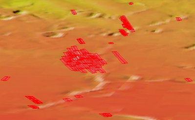
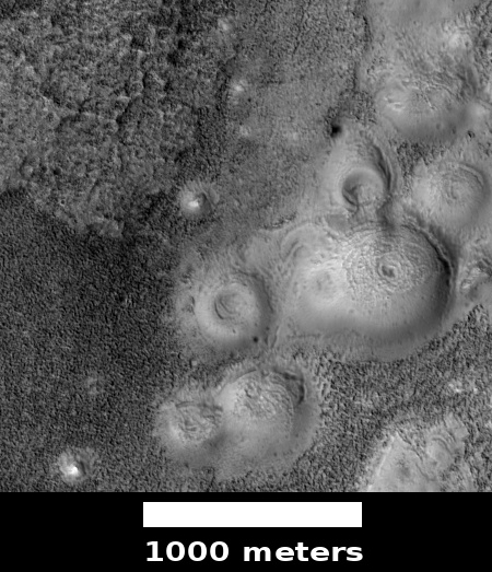
Since then there have been extensive efforts to locate the lander’s remains on the surface, all to no avail. Though Mars Global Surveyor, in orbit at the time, tried to find it, its resolution was not sufficient. In recent years Mars Reconnaissance Orbiter (MRO) has taken several dozen high resolution images of the estimated landing area, two of the most recent were included in the August 2018 image release. The image on the right is a cropped section of one of those images, illustrating the difficulty of the search. (If you click on the image you can explore the full version.) The other image is quite similar.

As the southern polar cap shrinks and grows seasonally, it produces endless numbers of black spots from the release of underground dust as the carbon dioxide dry ice sublimates into gas. Moreover, the growth and retreat of the dry ice cap changes the landscape, periodically covering any remains of the rover as well as quickly removing many of the ground disturbances that the crash might have caused. In the almost two decades since the lander’s crash landing, about ten Martian years have passed, meaning that cap has melted and frozen ten times over this region in that time.

Images taken by MRO of Mars Polar Lander landing area

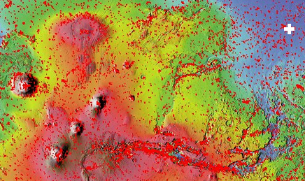
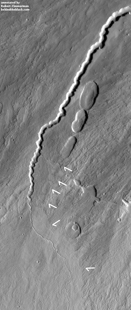
The image on the right shows the footprint of all the images that MRO has so far taken of the Mars Polar Lander landing area. If you are ambitious and want to get your name in the news, all you have to do is spend some time combing through those images and find the lander there. Every one of these images is available for public download at full resolution. Go to HiRise image archive, hover your mouse over latitude 77 degrees south, longitude 166 degrees east, and click several times to zoom in. You then change the selector icon at the top from “+” to “the arrow”. When next you click on any portion of that footprint it will show you a bunch of the images taken, all of which you can now download and inspect.

If you are successful and find the lander, please let me know. It would be nice to make that announcement here on Behind the Black.

0 comments

Inexplicable high latitude Martian terrain

Inexplicable high southern latitude Martian terrain

Strange image time! The image on the right, reduced in resolution to post here, comes from the August 1, 2018 image release from the high resolution camera on Mars Reconnaissance Orbiter (MRO). (If you click on the image you can see the full resolution version.) I have not cropped this image at all, so that you can see all of its swirling terrain.

This image did not come with a caption. The image site merely describes this terrain as having an “interesting morphology.” The location, in the very high southern latitudes (78 degrees south) just outside the southern rim of a very large crater, provides a slight explanation, as the growth and retreat of the Martian carbon dioxide polar caps is known to create very strange landforms. These swirling flows are obviously an example of one such landform.

The crater rim is just off of the top of the image and parallel with it. Therefore, the apparent erosional flows going around the hills and mesas are running parallel to the rim, not down from it. The black specks scattered about are probably points where dust was released as the carbon dioxide turned from ice to gas, a process that at the high latitudes on Mars often causes what planetary scientists call “spiders.”

I will not even try to make a guess at the process that formed what we see here. The image itself was taken on June 16, 2018 as part of a seasonal monitoring effort, which means scientists expect there to be changes occurring here from year to year as the polar cap shrinks and grown. An almost identical image had been taken two years ago, on December 18, 2016, and shows almost no black specks, probably because of the different time in the Martian year. A much closer comparison of both high resolution images would be necessary to tease out any more subtle changes.

4 comments

Volcanic rills and lava tubes on Mars

Rills and lava tubes on Pavonis Mons

Cool image time! The image on the right, cropped somewhat to show here, was taken by Mars Odyssey of the southwestern slope of Pavonis Mons, the middle volcano of the line of three giant volcanoes located between the biggest volcano in the solar system, Olympus Mons, and the biggest canyon in the solar system, Marineris Valles. The slope goes down to the south, from the top to the bottom of the image. As noted on the image page,

The channel and nearby oval depressions are both related to the flow of lava. Narrow lava flows can create channels. The cooling of the top of the channel will form a roof over the flow, creating a tube beneath the surface. After the lava stops flowing the tube can empty, leaving a subsurface void. The roof will then collapse into the void forming the oval surface features.

I have added arrows to the image to draw your eye to the features that extend south in line with those oval depressions, eventually widening out to resemble a river delta, with the obvious rill probably indicating the lowest point in that delta.

Though the oval depressions are likely sections of a lava tube that collapsed, the features in line with those depressions suggest that the tube itself might still exist below the surface to the south, feeding into that delta where the rill meanders. It is also possible that my desire to find underground voids here, where glacier ice might possibly exist, might be skewing my conclusion. It could also be that the lava tube ended at these depressions, and what the features indicate is a wide surface flow, later embellished by the smaller flow of the meandering rill.

2 comments
1 149 150 151 152 153 212