Europe picks landing site for its ExoMars 2020 rover

The European Space Agency (ESA) has chosen the landing site for its ExoMars 2020 rover, a generally flat area with scattered craters dubbed Oxia Palum.

After over 4 years of careful study of HiRISE and more recently CaSSIS images Oxia Planum was chosen because scientists were convinced that its fine grained sediments, deposited during the ancient Noachian epoch were ideally suited for the Exobiology rover. With an enormous catchment area the sediments will have captured organics from a wide variety of environments over a long period of time, including areas where life may have existed. The fine sediments should also be ideal for the ExoMars drill – it aims to get to 2 metres depth.

Remote identification with the Mars Express and Mars Reconnaissance Orbiter Infrared spectrometers shows the presence of clays and other minerals giving clues to its aqueous history. A large group of scientists have been working on proposing, characterising and down selecting the sites, all of which had fascinating aspects, but Oxia Planum is the clear winner on both science and engineering constraints.

Based on my analysis of the last two candidate sites, I would guess that they also picked Oxia Planum because it is less spectacular, flatter, and thus poses less risk. It also means the images from there will be a bit more boring for the ordinary person.

2 comments

Mars rover update: November 8, 2018

Summary: Curiosity finally gets drill samples from the top of Vera Rubin Ridge. Opportunity’s silence now extends to five months.

For a list of past updates beginning in July 2016, see my February 8, 2018 update.

Curiosity

Curiosity's travels on and off Vera Rubin Ridge

For the overall context of Curiosity’s travels, see Pinpointing Curiosity’s location in Gale Crater.

The traverse map on the right, unchanged from my last rover update on July 17, 2018, shows almost all of Curiosity’s travels on Vera Rubin Ridge. The yellow dotted line is the oldest travel, up onto the ridge and then back down to get a successful drill sample. The green dotted line shows the rover’s return back up onto the top of the ridge, where it attempted and failed to drill into the ridge’s top layer, then experienced a serious computer issue in mid-September that essentially shut down science operations for about five weeks.

With the resumption of science operations about two weeks ago, the rover has moved a short distance on the top of the ridge to a new drill location, where it finally succeeded this week in drilling a hole in the hardest top layer of Vera Rubin Ridge.
» Read more

2 comments

Puzzling fractures on Mars

Fractures on Mars

Cool image time! Today the Mars Reconnaissance Orbiter (MRO) science team released another month’s worth of images from the spacecraft’s high resolution camera. The picture on the right, reduced in resolution to post here, was the first image that I took a close look at, and decided it was worth posting immediately. If you click on the image you can see the full resolution version.

This image lacks a caption, but the release webpage is titled “Fractured Crater Floor.” It shows several cross-crossing fissures, some wide enough for dust to gather within into sand dunes. The fractures themselves appear to be cutting across a bulging dome.

My first reaction was to wonder where the heck this crater was on Mars, how big was it, and how dominate were the fractures within its floor. The image itself does not answer any of these questions. The fractures could be filling the floor, or not, and the crater could be small or big. Moreover, its location might help explain the cause of the fractures.

To understand any of the images from MRO it is always important to zoom out to get some context.
» Read more

3 comments

SpaceX’s Tesla passes Mars’ orbit

Capitalism in space: The Tesla roadster that was put into solar orbit by the first Falcon Heavy launch in February has now successfully flown beyond Mars’ orbit.

The significance of this achievement is that this payload was put into solar orbit by a private company, using its own funds. The government had nothing to do with it.

For the entire history of the space age such a thing was considered absurd and impossible. You needed government to fund and build these big space projects. With this launch SpaceX and Elon Musk once again demonstrated how that accepted wisdom was bunk.

8 comments

NASA completes final parachute test for 2020 Mars rover mission

NASA has completed the third and final parachute test for its as yet unnamed 2020 Mars rover mission.

Three separate test launches (one Oct. 9, 2017, April 20, 2018, and Sept. 7, 2018) determined which parachute design would be used for the Mars 2020 mission. In 2012, a similar parachute concept was used for the Curiosity rover mission.

For this test, NASA said the parachute, which was made of nylon, Kevlar and Technora fibers, was packed into a “small drum-sized bag” before being launched to an altitude of about 23 miles (37 kilometers) and a speed of about Mach 1.8. Then, within less than a half-second, the 180-pound parachute was deployed and fully inflated with a volume of “a large house.”

Though doing engineering tests to prove your concept always makes sense, didn’t NASA do this for Curiosity, which then proved its parachute concept further by actually landing on Mars successfully? The 2020 rover is supposed to be saving money by using the Curiosity design. Why were these tests necessary?

5 comments

The vast northern plains of Mars

The vast northern plains of Mars

Cool image time! Actually, this image, found in the October image release from the high resolution camera of Mars Reconnaissance Orbiter (MRO), is not that interesting, in its own right. Context is all!

The image on the right is a small section cropped and reduced in resolution from the full image, which you can see by clicking on it. It shows one of the only interesting features in this long image strip, a small mesa sticking out all by itself in a flat featureless plain pockmarked by various small craters.

The release has no caption, though it is entitled “Northern Plains Survey.” The northern plains, while having a lot of interesting features that attract the attention of planetary scientists and thus get photographed at high resolution, is mostly featureless, at least at the resolution of the wide field survey cameras on many Mars orbiters. In order to know what is really there, they need to take high resolution images systematically, of which this image is obviously a part.

Overview image

The problem is that there is so much ground to cover. This particular image was taken of a spot in the middle of the plains just to the north of the drainage outlets from Valles Marineris, as shown by the context map to the right. The tiny white spot to the right in the middle of the blue plains north of those drainage outlets is the location of this image.

Detail area of overview map

To understand how much ground needs to be covered, to the right is a close-up of the area shown by the white box in the first image above, with red rectangles indicating where MRO has already taken images. The white cross is the subject image. As you can see, most of this immense plain has not yet been imaged. It is almost as if they threw a dart to pick this one location. Most everything around it remains unseen at high resolution. Thus, to understand the geology of this one image is hampered because the surrounding terrain remains unknown, in close detail.

Mars is a big place. It is an entire planet, with the same land surface as the Earth’s continents. It still contains many mysteries and unexplored places. It will take generations to see it all.

1 comment

NASA decides to continue to ping Opportunity

NASA has decided to continue through January its effort to both listen and send signals to Opportunity in the hope of bringing it to life.

The 45-day deadline passed late last week. But NASA will continue active listening — a strategy that involves both sending commands to Opportunity and listening for any peeps the six-wheeled robot may make — for several more months at least, agency officials announced yesterday. “After a review of the progress of the listening campaign, NASA will continue its current strategy for attempting to make contact with the Opportunity rover for the foreseeable future,” NASA officials wrote in a mission update yesterday. “Winds could increase in the next few months at Opportunity’s location on Mars, resulting in dust being blown off the rover’s solar panels,” they added. “The agency will reassess the situation in the January 2019 time frame.”

This is exactly what the planetary scientists wanted. Their hope is that, with the beginning of dust devil season in November, the chances will then increase for removing the dust that likely covers the rover’s solar panels. It is thought that the rover has a better shot at coming back to life during this time period.

0 comments

The steep slumping wall of a Martian volcano caldera

Caldera wall

Cool image time. The Mars Reconnaissance Orbiter science team today released a nice captioned image of the steep wall of the caldera of Ascraeus Mons, the northernmost of the three giant volcanoes that lie to the east of Olympus Mons, the biggest volcano of all. The image on the right, reduced and cropped, shows that steep wall, with full image available by clicking on it. The caption from the release focuses on the fluted upper parts of the wall.

We can see chutes carved into the soft dust that has built up on the slope, with some similarities to gully landforms elsewhere on the planet.

More revealing to me is how this image reveals the slumping that is slowing eroding the caldera’s walls while also making that caldera larger. First, the plateau above the cliff shows multiple small cliffs and pit chains, all more or less parallel to the wall. This suggests that the plateau is over time breaking apart and falling into that caldera. Think of it as an avalanche in slow motion, with the upper plateau separating into chunks as sections slowly tilt down toward eventual collapse. As these chunks separate, they cause cracks to form in that plateau, and hence the parallel cliffs and strings of pits.

On the floor of the caldera we can see evidence of past chunks that did fall, piled up in a series terraces at the base of the wall. These are covered with the soft dust that dominates Martian geology. That soft dust also apparently comprises much of the wall’s materials, and almost acts like a liquid as it periodically flows down the wall, producing the chutes at the top of the wall.

The weak Martian gravity here is an important factor that we on Earth have difficulty understanding. It allows for a much steeper terrain, that also allows structurally weaker materials to hold together that would be impossible on Earth.This image gives a taste of this alien geology, on a large scale.

2 comments

Curiosity resumes science operations

Though NASA has yet to announce this officially, Curiosity’s science team has made it clear that they are in the process this week of resuming full science operations.

Today was the first day of planning with the full science team since Curiosity had an anomaly on sol 2172. It has been a over a month since we last looked at the “workspace,” the region in front of the rover that the arm can reach, and there were some surprises in store for us! Before the anomaly, the rock was covered with gray-colored tailings from our failed attempt to drill the “Inverness” target, as seen in the Mastcam image from sol 2170. In the new image above, however, those tailings are now gone – and so is a lot of the dark brown soil and reddish dust. So while Curiosity has been sitting still, the winds have been moving, sweeping the workspace clean.

Those operations can also be seen in the images the rover is sending down. For the first time in almost six weeks images are arriving daily, from multiple cameras, and in large numbers.

What we yet don’t have is a detailed description outlining why it took so long to get the second computer up and running, and what they are doing, if anything, to repair the computer that produced the problems last month.

0 comments

Scientists calculate Mars methane release

A new model describing how warmer weather could cause the seasonal spikes of methane on Mars matches the data from Curiosity in Gale Crater.

Moores and his colleagues analysed how methane might seep upwards through cracks and fissures in the Martian soil until it enters the atmosphere. Warming the soil could allow the gas to leak into the air, their calculations show. Seasons on Mars are complex, especially at Curiosity’s location so close to the planet’s equator. But the highest methane levels do appear just after the warmest time of the year, suggesting that heat spreading downward allows more of the gas to be released.

The amount of gas that the scientists estimate is entering the atmosphere is a good match for the measurements Curiosity has made at Gale crater, Moores told the American Astronomical Society’s Division for Planetary Sciences meeting in Knoxville, Tennessee. The methane’s ultimate source is still a mystery. But the work could help to explain the gas’s seasonal ebb and flow, he said. [emphasis mine]

The highlighted sentence is the most important. All they have done is found that they can model the pattern of seasonal release. They still have no idea whether the methane comes from a geological or biological source, which is of course the real question.

0 comments

Intriguing water-ice cloud on Mars

Water-ice cloud over Arsia Mons

An extended water-ice cloud has formed recently on the downwind side of the large Martian volcano Arsia Mons. The image above, cropped to post here, was taken by Europe’s Mars Express orbiter, and shows the cloud extending westward from the volcano.

In spite of its location, this atmospheric feature is not linked to volcanic activity but is rather a water ice cloud driven by the influence of the volcano’s leeward slope on the air flow – something that scientists call an orographic or lee cloud – and a regular phenomenon in this region.

The cloud can be seen in this view taken on 10 October by the Visual Monitoring Camera (VMC) on Mars Express – which has imaged it hundreds of times over the past few weeks – as the white, elongated feature extending 1500 km westward of Arsia Mons. As a comparison, the cone-shaped volcano has a diameter of about 250 km.

… Mars just experienced its northern hemisphere winter solstice on 16 October. In the months leading up to the solstice, most cloud activity disappears over big volcanoes like Arsia Mons; its summit is covered with clouds throughout the rest of the martian year.

However, a seasonally recurrent water ice cloud, like the one shown in this image, is known to form along the southwest flank of this volcano – it was previously observed by Mars Express and other missions in 2009, 2012 and 2015.

What the article does not mention about these seasonal water ice clouds is that they are thought to be related to the evidence of past glaciers on the volcano’s western slopes. Some scientists believe that significant underground ice, left over from those glaciers, is what causes the clouds.

0 comments

Changes on the slopes of Olympus Mons?

Dark splotches on slopes of Olympus Mons

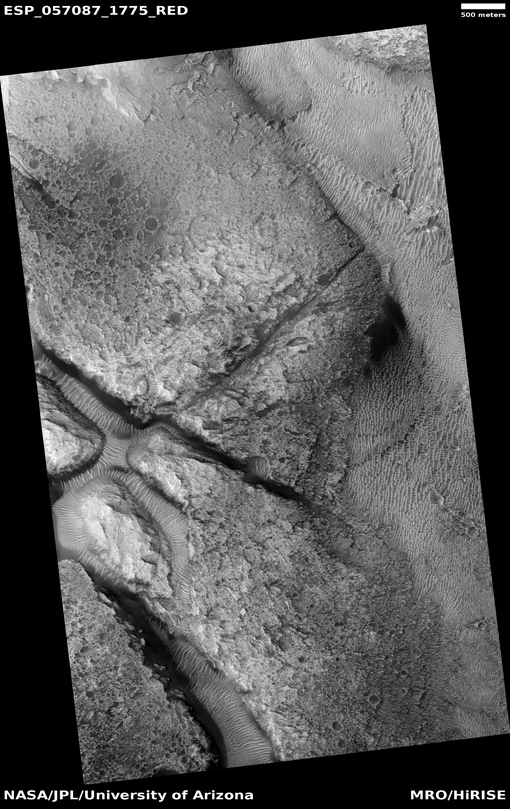
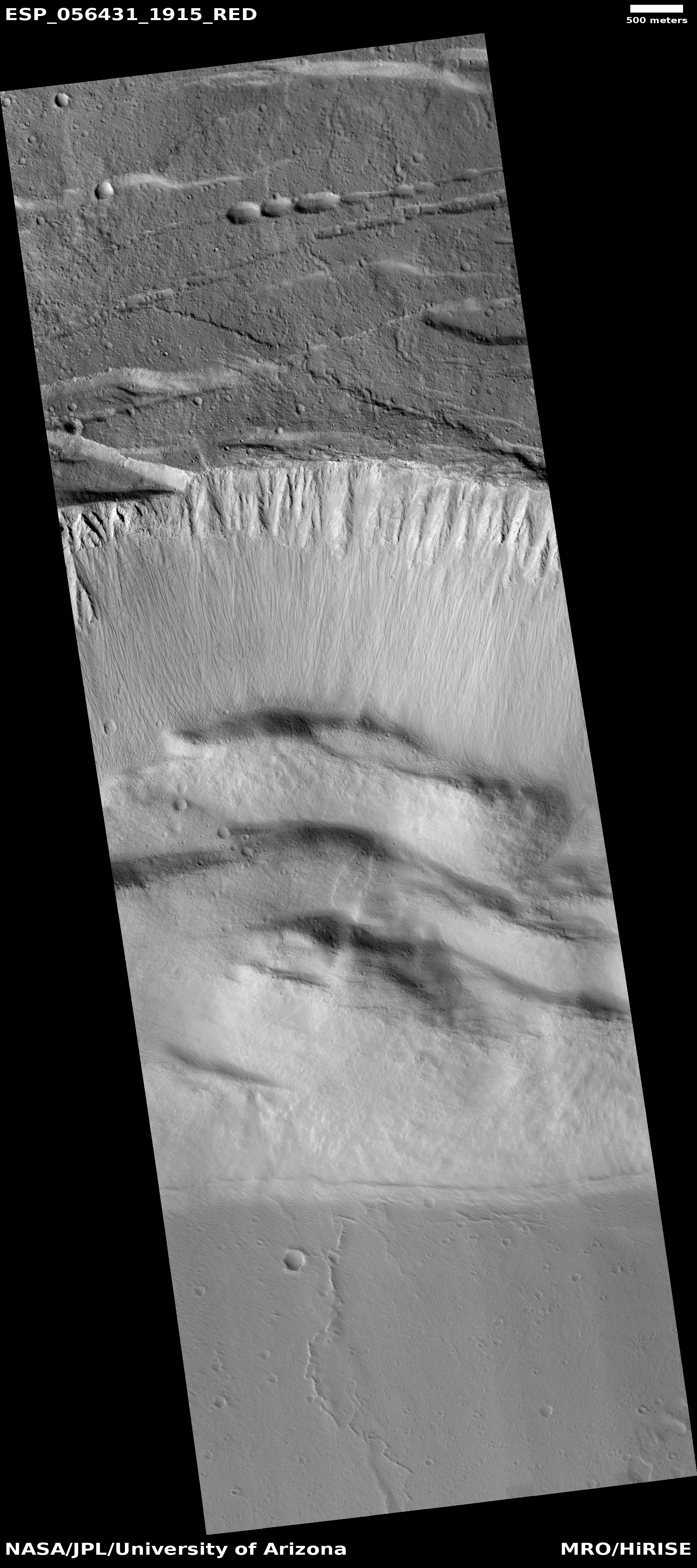
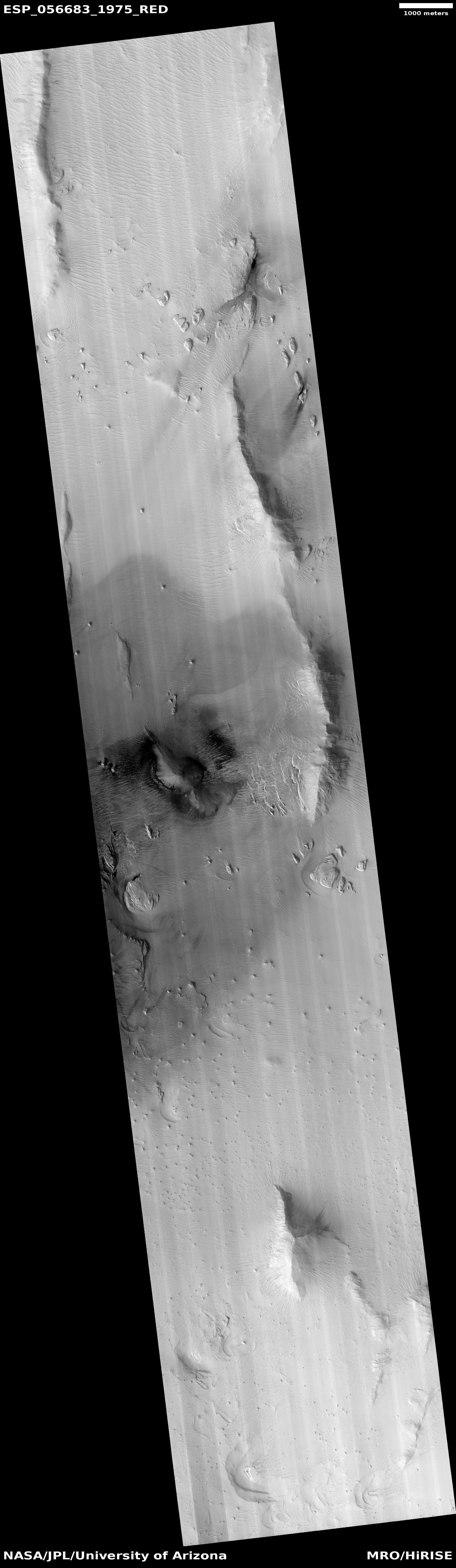
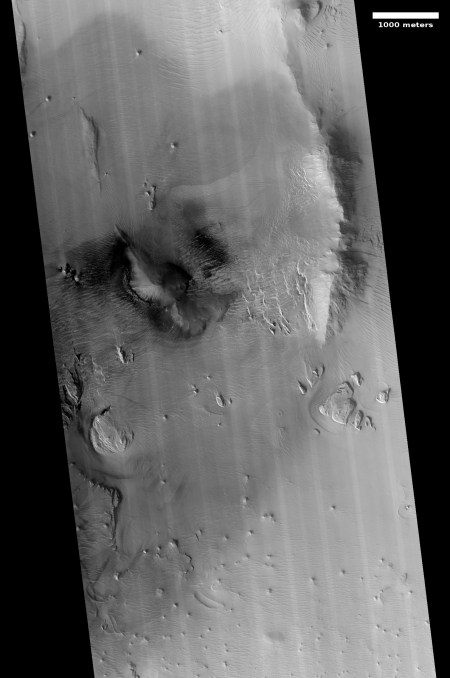
Cool image time! In reviewing the many images from the October image release from the high resolution camera on Mars Reconnaissance Orbiter (MRO), I came across two images, here and here, labeled “Change Detection in Olympus Maculae.” The image on the right is a cropped and reduced section of the first image, centered on the area of most interest. If you click on the image you can see the full photograph.

I did some research to see if I could find the changes indicated by this title. The location is an area on the outer western slopes of Olympus Mons, the largest volcano in the solar system. I found that MRO has taken images of this location twice before, in 2007, in 2009. I spent about fifteen minutes trying to find something that had changed, but was unable to locate anything, other than what look like a few wind-blown streaks probably caused by dust devils. I suspect I do not know what to look for.

Maybe my readers can spend some time and find these changes. If you do, please let us know in a comment.

Nonetheless, these two images revealed an area on the slopes of Olympus Mons that is most intriguing. It appears that there is a whole string of these dark splotches in this area, all of which have been carefully imaged by MRO several times. These splotches, along with the image titles, suggest that this might be area where there is activity from below that is causing the surface to darken. Could it be volcanic? Not likely. More likely is that there is underground frozen water located here, and like the spiders at the poles, this ice periodically pushes up as it sublimates to burst out as gas, and in the process darkens the surface.

If this guess on my part is correct, it suggests that this is an area in the mid-latitudes of Mars where water might be reasonably accessible. For future settlers this would be a significant discovery. And if my guess is wrong no matter. The features are puzzling, which explains why the scientists are aiming MRO at them repeatedly.

If I was to writing my science fiction novel Pioneer today, this is where I would have placed the discovery of the body of the Sanford Addiono, the astronaut who had disappeared on an asteroid near the orbit of Jupiter forty-six years previously. As the press release for the book’s release noted,

How Addiono had gotten to Mars from a distant lost asteroid–without a spaceship–was baffling.

That riddle was magnified by what Addiono had brought back with him. Among his effects was a six-fingered robot hand that had clearly been made by some alien civilization, along with a recorder and memo book describing what Addiono had seen.

What better place to put the start of this mystery but here, on a dark splotch on the slopes of Olympus Mons that also indicates its own geological mystery, a place some underground activity might be reshaping the surface of Mars.

1 comment
1 147 148 149 150 151 212