
Cerutti Mastodon Discovery
An evening pause: This story of the discovery of a mastodon site in San Diego strongly challenges all theories about the first human arrival in North America.
Hat tip Cotour.
An evening pause: This story of the discovery of a mastodon site in San Diego strongly challenges all theories about the first human arrival in North America.
Hat tip Cotour.
Click for full image.

Click for full image.
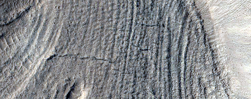
Cool image time! The image above, cropped to post here, was taken on December 2, 2019 by the high resolution camera of Mars Reconnaissance Orbiter (MRO) of a crater in the northern lowlands of Mars. It focuses in on the strange lineated ruts and ridges found on the crater’s central floor, as indicated by the black box on the wide shot to the right.
The north-south alignment of these groves suggests to me that they are wind caused, as if dust and sand had ponded in the crater’s lowest point and was then shaped by the prevalent winds. They also appear solid and old, as if this shaping occurred a long time ago and they are now decaying with time.
This location is at the same latitude as the plains around Erebus Montes, the prime candidate landing site for SpaceX’s Starship, and a region where a lot of shallow subsurface ice has been detected. It lies due west of that region, separated by the north-south Phlegra Montes mountain chain. At this latitude, 36 degrees north, scientists have found ample evidence of water ice, though some regions have more than others. This crater sits on the edge of this particular rich area, which might explain why the crater looks more solid and dry than others at similar latitudes. There simply might be less ice here, or the ice lies deeper below the surface.
I am off with Diane on a hike this morning, so this cool image fills in for my normal morning news posting. I should catch up this afternoon.
Link here. As expected, the situation in China continues to be serious and somewhat out of control. The key data point however is this:
The number of confirmed infections across China has risen to 7,711, resulting in 170 deaths. By comparison, there were 5,327 cases of severe acute respiratory syndrome (SARS) in China during the 2002-2003 outbreak, although that virus was more deadly, claiming 349 lives.
In about a week the number of those infected has grown exponentially, far far faster than the previous SARS epidemic. In one week it just about passed SARS, which took a year to accumulate the same numbers.
At the same time, coronavirus still appears relatively mild, having produced half the deaths, about 2% of all those infected. This number however can easily rise, as the disease is still in its early stages for the majority of those infected.
So far the detected cases outside of China remain small, but they are also on the rise, including the first detected human-to-human transmission entirely within the U.S.
Once again, it is essential that no one panic over this virus. Its potential danger should also not be poo-pooed. Until we know more, it poses a threat that must be faced.
Citizen scientist Brian Swift has created a new movie from images taken by Juno during its December 25th close pass of Jupiter, the 24th such flyby of the spacecraft’s mission.
I have embedded the movie below. While it isn’t as spectacular as previous movies (see here, here, here, and especially here and here), as it appears that either Juno did not get quite as close, or Swift did not shape it to give that impression, it is still most breathtaking.
The Parker Solar Probe yesterday completed its fourth orbital close fly-by of the Sun, setting a new speed record.
The spacecraft traveled 11.6 million miles from the Sun’s surface at perihelion, reaching a speed of 244,225 miles per hour. These achievements topple Parker Solar Probe’s own previous records for closest spacecraft to the Sun — previously about 15 million miles from the Sun’s surface — and fastest human-made object, before roughly 213,200 miles per hour.
Parker will continue to break these records with each orbit.
An evening pause: Hat tip Tom Biggar.
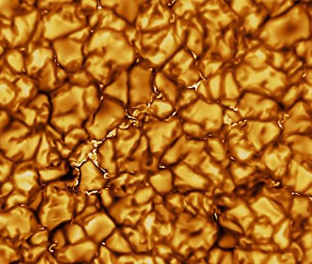
Scientists have released the first images of the Sun taken by the new Daniel K. Inouye Solar Telescope on the island of Maui in Hawaii.
The image to the right, cropped to post here, is today’s released image, a close-up of the Sun’s surface granular structure, with each cell about the size of Texas.
Right now most of the telescope’s instruments are not yet on line. It is expected the telescope will become fully operational in July.
After forty years of operation and successfully leaving the solar system, Voyager 2 has experienced a technical issue that caused it to go into safe mode.
According to NASA, Voyager 2 failed to perform a scheduled maneuver on Saturday January 25. The craft was due to rotate a full 360 degrees to calibrate its magnetic field instrument, but for some reason the action was delayed. That in turn meant that two particularly power-hungry systems were left running at the same time, which overdrew the available power supply.
…As of January 28, the team managed to turn off one of those high-power systems, allowing some scientific instruments to be switched back on. Engineers are currently analyzing data to figure out the status of the rest of the systems, to work out how to turn off the second one and return the craft to normal operations.
Click for full image.
Don’t ask me to explain the geology on today’s cool image, rotated, cropped and reduced above. Taken by the high resolution camera on Mars Reconnaissance Orbiter (MRO) on August 16, 2019, the image’s uncaptioned website merely calls these “Convergent and Overlapping Narrow Curved Ridges.”
I don’t know why the sand in the hollows appears light blue, or even if it is sand. I don’t know what created the ridges, or why they seem to overlap each other randomly, or why they seem to peter out to the south.
I am sure there are planetary scientists out there who have theories that might explain these features. I also know that they would forgive me if I remained skeptical of those theories. This geology is a puzzle.
The location of these ridges is in the southeast corner of Hellas Basin, which I like to call the basement of Mars as it is the equivalent of the United States’ Death Valley, having the lowest relative elevation on the planet. As I have noted previously, the geology in this basin can be very strange. To my eye it often invokes a feeling that we are looking at Mars’s “uttermost foundation of stone” (to quote Tolkien), frozen lava that flowed in many ways and then froze in strange patterns.
Or not. Your guess is as good as mine.
According to a company that monitors objects in low Earth orbit, two abandoned satellites might actually collide on January 29..
The two satellites, NASA’s IRAS space telescope and the experimental U.S. Naval Research Lab satellite GGSE-4, will swing past each other at 6:39 p.m. EST at an altitude of about 559 miles in the skies above Pittsburgh, Pennsylvania. They’ll be hurtling along their orbit at a relative velocity of about 32,880 miles per hour and could swing within 50 feet of each other.
LeoLabs noted that, at the time of the tweet, the odds of a collision were about 1 in 100 and said the relatively large size of the two spacecraft increased the risk of a collision.
IRAS was the first infrared space telescope ever launched, and operated for ten months after its launch in 1983. The other spacecraft was a National Security Agency test satellite of surveillance technology.
In a new paper released this week, scientists using instruments on both Mars Odyssey and Mars Reconnaissance Orbiter have found more evidence that there is a large amount of widespread ice close to the surface in the Martian mid-latitudes. As the scientists note in their abstract:
We show that water ice is present sometimes just a few centimeters below the surface, at locations where future landing is realistic, under mobile material that could easily be moved around. This ice could be exploited on‐site for drinking water, breathable oxygen, etc., at a much lower cost than if brought from Earth.
They deduced this by looking at how that ice would change the seasonal temperatures in the atmosphere directly above. Cooler regions suggested more ice close to the surface, while warmer regions suggested either no ice or ice deep below the surface. While this approach is indirect and did not directly detect ice, their conclusions match perfectly with all previous research. Below is a global map of Mars taken from the paper’s the supplementary material [docx file], reduced and annotated by me, showing the regions that seem to have ample shallow ice. Regular readers of Behind the Black will instantly recognize these locations.
» Read more

Click for full image.
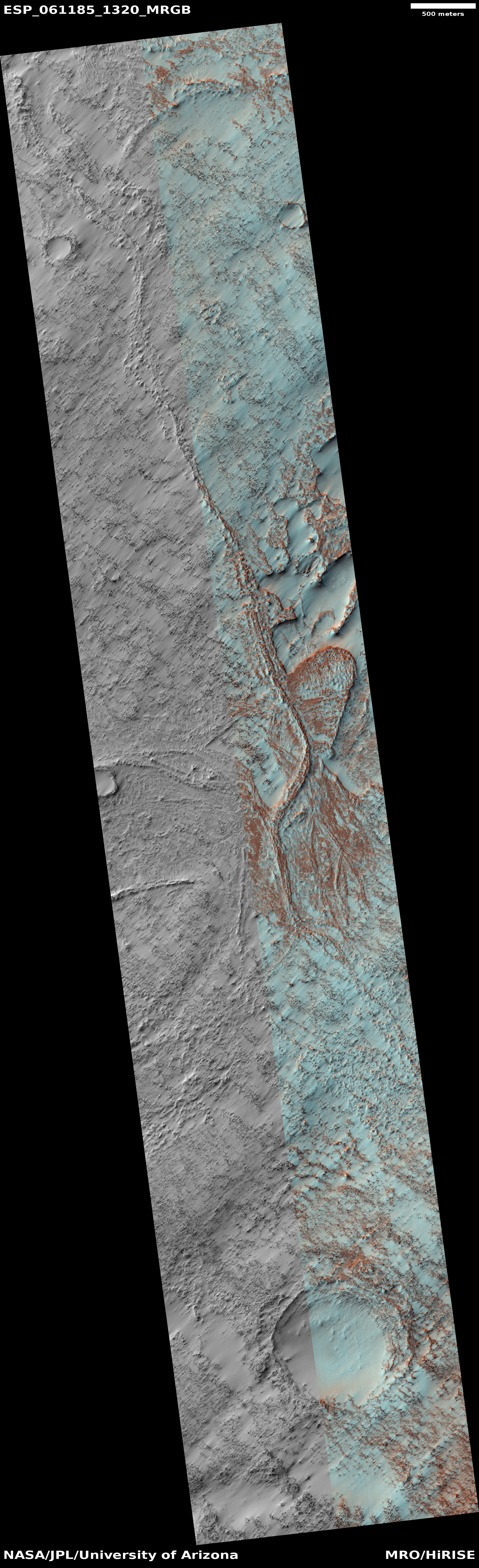
Cool image time! The photo on the right, rotated, cropped, and reduced to post here, was taken by the high resolution camera of Mars Reconnaissance Orbiter (MRO) on October 7, 2019. In one image it encapsulates the process that forms one of the more intriguing and major Martian geological features, dubbed chaos terrain.
Chaos terrain is typically a collection of mesas separated by straight-lined canyons. It is found in many places on Mars, most often in the transition zone between the southern highlands and the northern lowlands where an intermittent ocean might once have existed. It is believed to form by erosion, possibly caused by either flowing water or ice, moving along fault lines. As the erosion widened the faults, they turned into canyons separating closely packed mesas. With time, the canyons widened and the mesas turned into a collection of hills.
This image shows the beginning of this process. It is centered on a fault line running from south to north. In the south all we can see is the fault expressing itself as a very shallow small depression in the plains. As we move north the depression widens and deepens. The material inside the depression near the top of the photo could very well be a buried inactive ice glacier. Several million years ago, when the inclination of Mars was much higher and the mid-latitudes were much colder than the poles, the water ice at the poles was sublimating from the poles to those mid-latitudes where it fell as snow. At that time this glacier was likely active, helping to grind out this canyon.
The image was taken at the south border of a chaos region dubbed Nilosytis Mensae, as shown by the overview maps below.
» Read more

Click for full image.
Cool image time! The image to the right, cropped and reduced to post here, is one of those terrain sample images the science team of the high resolution camera of Mars Reconnaissance Orbiter (MRO) takes periodically when they have a gap in their observation schedule with no specific requests for images of the terrain below. Still, they need to use the camera regularly to keep its temperature maintained, so they then take a somewhat random picture over that terrain, based partly on information from lower resolution images but without a strong sense of what they will find.
In this case, they found what I dub pimples, raised mounds with small holes at their peaks. The image, taken on November 30, 2019, is located is in the northern lowlands, at a latitude (45 degrees) where subsurface ice is possible. Thus, we could be looking at water ice volcanoes.
Very few high resolution images have been taken of this area, with no others close by. Thus, the overall context of these mounds is hard to gauge. They could be widespread, or very localized.
The unknowns here and general lack of research suggests this location and these mounds are ripe research for some postdoc student interested in planetary geology.
OSIRIS-REx has successfully completed the first of a series of increasingly closer fly-overs of its primary sample grab sites on the asteroid Bennu.
The spacecraft got as close as about 2,000 feet in order to take more high resolution images of the Nightingale landing site where they hope in August to do a touch-and-go sample grab.
A similar flyover of the backup sample collection site, Osprey, is scheduled for Feb. 11. Even lower flybys will be performed later this spring – Mar. 3 for Nightingale and May 26 for Osprey – as part of the mission’s Reconnaissance C phase activities. The spacecraft will perform these two flyovers at an altitude of 820 feet (250 m), which will be the closest it has ever flown over asteroid Bennu’s surface.
Link here. The numbers of people so far infected is hardly gigantic, less than 450 worldwide, with almost all confined to one province in China.
You can also find out some general information about this particular virus as well as other related viruses, such as SARS and MERS, in this separate article. All are far less threatening that press reports make them appear. For example, SARS only infected 8,000 people total, killing a little less than 10% of those infected.
This new virus appears so far to be even less deadly, with nine deaths total, about 5%.
While under no condition should this outbreak be ignored or poo-pooed, it is very important to recognize that, at least so far, it is hardly an epidemic that will wipe out civilization. This could change with time, but I doubt it.
The uncertainty of science: Despite fears that the radioactivity released from the Fukushima nuclear accident would make life difficult if not impossible within the 80-mile radius exclusion zone surrounding the reactor, animals are thriving there, in large unexpected numbers.
Now, nearly a decade after the nuclear accident, the wildlife populations appear to be thriving. Animals are most abundant in areas still devoid of humans, with more than 20 species captured in the UGA’s camera study.
Particular species that often find themselves in conflict with humans, especially Fukushima’s wild boar, were most often photographed in human-evacuated areas. Without the threat of humankind, wildlife is flourishing. In the years since the nuclear accident, Japan’s wild boar seems to have taken over abandoned farmland — even moving into abandoned homes. The government hired boar hunters to cull the population prior to re-opening parts of the original exclusion zone in 2017.
This phenomenon has happened before. Life inside the Chernobyl exclusion zone in Ukraine became an accidental wildlife preserve after humans left following the nuclear disaster there in April 1986. [emphasis mine]
This story, and that of Chernobyl, does not prove that radioactivity is harmless. Not at all. What it shows is that we know diddly-squat about its effects on life. For example, one study has shown changes in the weight and size of one species of monkey at Fukushima has shrunk, but have flourished nonetheless.
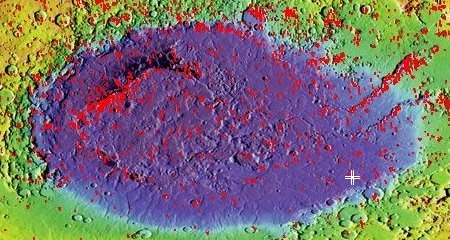
The uncertainty of science: Scientists think they have identified the oldest meteorite strike known on Earth, dated at 2.33 billion years ago, located in a known impact site in Yarrabubba, Western Australia.
Lead author Dr Timmons Erickson, from Curtin’s School of Earth and Planetary Sciences and NASA’s Johnson Space Center, together with a team including Professor Chris Kirkland, Associate Professor Nicholas Timms and Senior Research Fellow Dr Aaron Cavosie, all from Curtin’s School of Earth and Planetary Sciences, analysed the minerals zircon and monazite that were ‘shock recrystallized’ by the asteroid strike, at the base of the eroded crater to determine the exact age of Yarrabubba.
The team inferred that the impact may have occurred into an ice-covered landscape, vaporised a large volume of ice into the atmosphere, and produced a 70km diameter crater in the rocks beneath.
Professor Kirkland said the timing raised the possibility that the Earth’s oldest asteroid impact may have helped lift the planet out of a deep freeze. “Yarrabubba, which sits between Sandstone and Meekatharra in central WA, had been recognised as an impact structure for many years, but its age wasn’t well determined,” Professor Kirkland said. “Now we know the Yarrabubba crater was made right at the end of what’s commonly referred to as the early Snowball Earth – a time when the atmosphere and oceans were evolving and becoming more oxygenated and when rocks deposited on many continents recorded glacial conditions”.
Associate Professor Nicholas Timms noted the precise coincidence between the Yarrabubba impact and the disappearance of glacial deposits. “The age of the Yarrabubba impact matches the demise of a series of ancient glaciations. After the impact, glacial deposits are absent in the rock record for 400 million years. This twist of fate suggests that the large meteorite impact may have influenced global climate,” Associate Professor Timms said. [emphasis mine]
I truly believe they have determined the approximate age of this impact, making it one of the oldest known impacts. Implying however a “precise” linkage to other only vaguely known climate events, and inferring that the former was the cause of the latter seems to me to be a very large overstatement. Their data might suggest this conclusion, but the uncertainties here demand a bit less certitude..
Click for full image.
Time for a cool image that makes no sense. The photo on the right, cropped to post here, was taken by the high resolution camera on Mars Reconnaissance Orbiter (MRO) on November 15, 2019 of the floor of a crater, dubbed Dokka Crater, located in the high latitudes of the Martian northern lowlands. Uncaptioned but labeled “Undulations on Dokka Crater Ice Dome,” it shows a region of weird complex wave features, reminiscent of another weird Martian geological feature called brain terrain.
The problem is that brain terrain is generally found in the mid-latitudes, not the high latitudes. Both this feature and brain terrain however appear to associated with ice. In this case, these undulations are occurring on the ice dome that apparently sits inside Dokka crater, which is also likely to be related to the islands of ice found in many high latitude craters on Mars in the southern hemisphere..
In the case of the southern hemisphere ice-filled craters, scientists have found evidence suggesting that global wind patterns might affect their shape and placement within the craters. One wonders if this same factor is a part cause for these undulations in this northern hemisphere crater.
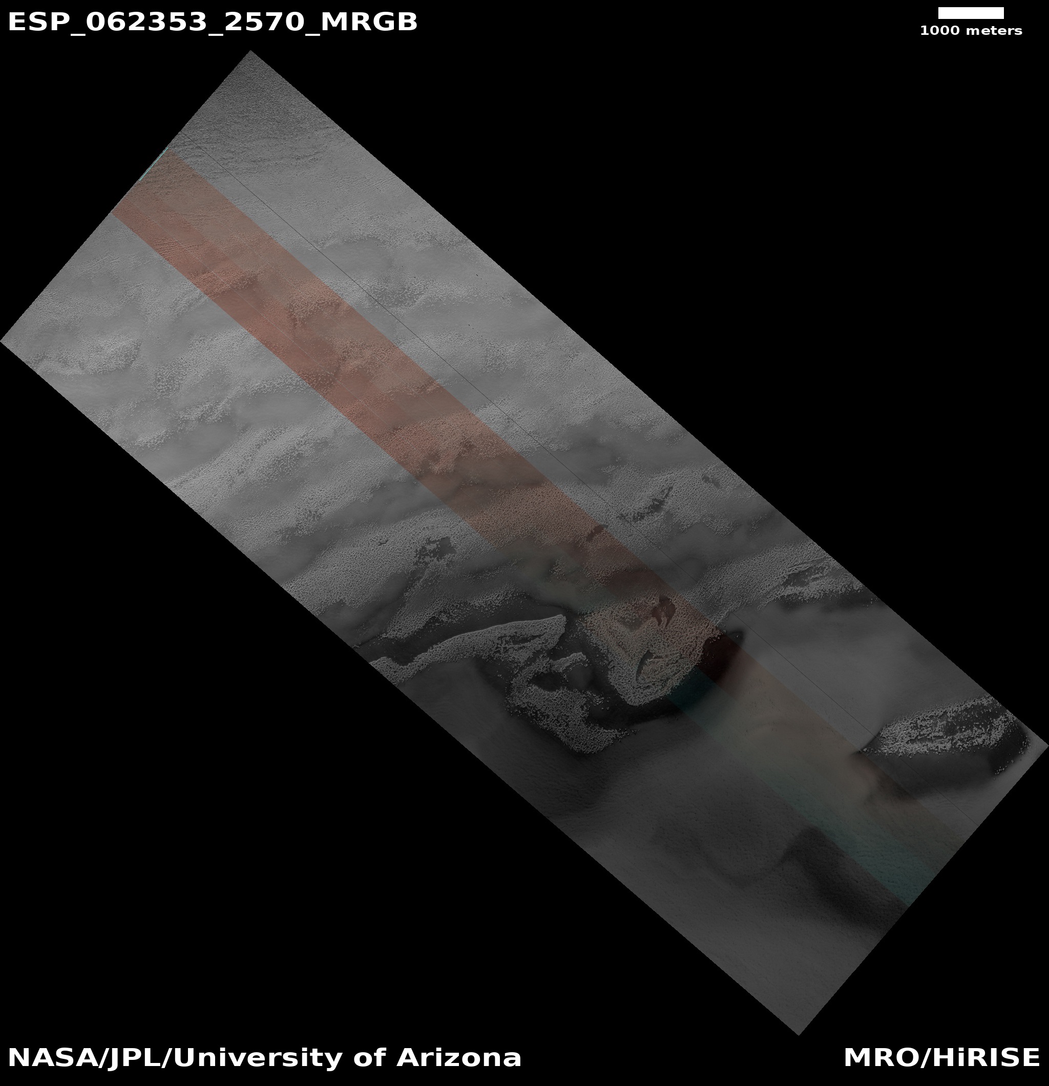
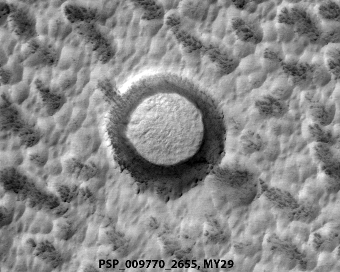
Click for full image.
Cool image time! The science team for the high resolution camera on Mars Reconnaissance Orbiter (MRO) last week released a very neat short movie compiled from images taken of an impact crater located on top of the northern polar ice cap of Mars. As noted by planetary scientist Alfred McEwen of the Lunar & Planetary Laboratory in Arizona in the image caption,
Shown here is an impact crater on the north polar ice cap, which contains an icy deposit on the crater floor. These inter-crater ice deposits shrink and expand or change shape or surface texture from year to year,
The image on the right, cropped and reduced to post here, is the most recent of these six images. The crater, which is about 200 feet in diameter, is the black speck in the center. The white streaks to the south of the crater, similar on all six photos, indicate that the prevailing winds come from the pole.
The animation zooms in on the crater so that you can see the details on its crater floor. And though the animation is fun, below the fold is a collage of all six photos, which I think makes it easier to see how the inter-crater ice deposits changed from summer to summer.
» Read more
The new colonial movement: China’s lander Chang’e-4 and rover Yutu-2 have been awakened for their 14th lunar day of operations on the far side of the Moon.
Both have now been operating more than a year, far longer than their planned three-month mission.