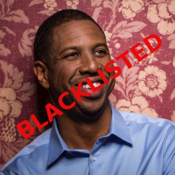
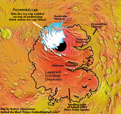
India to use PSLV 4th stage for orbital research and docking tests

The new colonial movement: India’s space agency ISRO now plans to conduct research, including docking tests, using the 4th stage of its PSLV rocket following normal commercial operations.

The PS4 is the last stage of the Polar Satellite Launch Vehicle (PSLV) rocket, which until now used to go waste after putting the spacecraft into the desired orbit. ISRO, in the last two attempts tried to keep PS4 alive in space, and was successful. As the next step, it has now called for experiments from national and international institutions. The experiments will cover six areas, including space docking

“The PS4-Orbital Platform (PS4-OP) refers to a novel idea formulated by ISRO to use the spent PS4 stage (fourth stage of PSLV) to carry out in-orbit scientific experiments for an extended duration of one to six months. The advantage being the stage has standard interfaces & packages for power generation, telemetry, tele-command, stabilization, orbit keeping & orbit maneuvering,” Isro said on Saturday.

All of this is engineering research, finding ways to operate in space effectively. More important, they are doing what SpaceX does, letting their commercial operations pay for their research and development. Rather than fly separate missions to do these engineering experiments, they will let their commercial customers pay for it.

Bridenstine: Artemis to cost $4-$6 billion per year

According to several reports this past weekend, NASA administrator Jim Bridenstine is now estimating the cost for the Trump administration’s Artemis lunar program at $20 to $30 billion, or $4 to $6 billion per year.

This has not been officially confirmed. Either way, I am not sure how Bridenstine will get this approved in the House, where the Democrats now have a policy to oppose any Trump proposal 100%. And if it doesn’t get approved, SLS will die after its second launch, as the bulk of this budget is to pay for its future flights to the Moon.

If a lower figure gets approved, that might force NASA to buy private rockets almost exclusively to get back to the Moon, rather than the mix of private and SLS as now proposed.

Stratolaunch for sale?

A report today says that the Stratolaunch company, including its giant airplane Roc, are up for sale.

Sources say Vulcan Inc. is looking to sell Stratolaunch, the space venture founded by the late Seattle billionaire Paul Allen, and one report says the asking price could be as high as $400 million.

That price tag was reported today by CNBC, quoting unnamed sources who were said to be familiar with the discussions.

Vulcan had nothing new to say about Stratolaunch’s fate, which has been the subject of rumors for months. “Stratolaunch remains operational,” Alex Moji, manager of corporate communications at Vulcan, told GeekWire in an emailed statement. “We will provide an update when there is news to share.”

Since the sources are all anonymous, it is wise to not take the story too seriously. At the same time, it seems to fit with events since the death of Paul Allen.

Update on development status of ULA’s Vulcan rocket

Link here. Overall the rocket seems to be on track for its planned April 2021 launch, except it appears ULA has decided to do that launch without two new components of the rocket that previously were planned, delaying their implementation.

First, it appears that Blue Origin’s BE-4 engine might not power the rocket’s first stage in its initial flights. It seems that both companies want that engine to first fly on Blue Origin’s New Glenn rocket, whose first launch is not set until 2021 as well.

This delay in the engine’s use has me wondering whether ULA has gotten cold feet about Blue Origin and its engine. It certainly seems to me that progress at Blue Origin has slowed considerably in the past year. For example, they promised manned flights of New Shepard that did not happen, and testing on the BE-4 seems to have gone underground.

In fact, the combination of increased hype and lack of progress has made Blue Origin and Jeff Bezos remind me increasingly of Virgin Galactic and Richard Branson, that team of endless unmet promises.

Second, it appears ULA has given the recovery and reuse of Vulcan’s first stage engines a very low priority. The technique they had chosen was to have the engines separate from the tanks and return to Earth by parafoil, protected by an inflatable heat shield. However,

A technology demonstration payload for the inflatable heat shield, which could also be used to deliver payloads to the surface of Mars, is slated to fly as a rideshare payload with NOAA’s JPSS-2 satellite aboard an Atlas V launch no earlier than 2022. [emphasis mine]

In other words, that reusable technology probably won’t be operational until well into the 2020s. Vulcan will likely be completely expendable for at least the first five years of its use.

ULA apparently has decided to take the safe technology route. Financially secure because of a $1 billion Air Force development contract to pay for Vulcan, combined with the military’s obvious desire to favor them in the awarding of future launch contracts, the company doesn’t have any incentive to innovate in any way to lower costs.

Hayabusa-2 completes close approach of target/manmade crater

Target on Ryugu's surface

Hayabusa-2 has successfully completed its close approach and reconnaissance of the positioning target it had placed on May 30 near the crater it had created on Ryugu on April 4.

The image to the right is the last navigational image taken at the spacecraft’s closest point. You can clearly see the navigational target as the bright point near the upper center of the image, to the right of the three larger rocks. This location also appears to be inside the manmade crater, based on earlier reconnaissance of that crater. The crater is in an area they have labeled C01, which is where they have successfully placed the target. It also appears that this is the smoothest area in C01, which will greatly facilitate their planned sample grab.

China announces international experiments to fly on its space station

The new colonial movement: China and the UN today jointly announced the nine international experiments that China will fly on its own space station, set to be completed by 2022.

The nine projects involve 23 entities from 17 countries in the fields of aerospace medicine, space life sciences and biotechnology, microgravity physics and combustion science, astronomy and other emerging technologies.

It seems to me that the competition in space is definitely heating up. Both China and Indian now plan their own space stations. And the Trump administration’s announcement that it will allow private commercial and competitive operations on ISS, is certainly going to lead eventually to more than one private station in orbit, plus ISS.

The result is going to be many different stations, all offering different capabilities and all in competition to lower the cost to get there and to do research or to sightsee. All are also going to be contributing aggressively in learning how to build vessels that humans can live on for long periods, which in turn will teach us how to build interplanetary spaceships. In fact, every one of these stations will be prototypes for those interplanetary spaceships.

Isn’t competition wonderful? After almost thirty years of boring international cooperation on ISS, with little new achievement or innovation, the space station competition coming in the next decade will revitalize space exploration in ways we as yet cannot imagine.

India to build its own space station

The new colonial movement: India announced yesterday that it is beginning design work on its own space station, with a plan to begin construction and launch following its first manned mission, dubbed Gaganyaan, in 2022.

Giving out broad contours of the planned space station, Dr. Sivan [head of India’s space agency ISRO] said it has been envisaged to weigh 20 tonnes and will be placed in an orbit of 400 kms above earth where astronauts can stay for 15-20 days. The time frame is 5-7 years after Gaganyaan, he stated.

The announcement came out of the first meeting of what ISRO calls its Gaganyaan National Advisory Council, designed to bring together people from India’s space industry to prepare for that first manned flight in 2022.

Bigelow announces four tourist bookings to ISS using Dragon

Capitalism in space: The private space station company Bigelow Aerospace announced yesterday that it has booked four tourists to spend from one to two months on ISS.

The bookings will fly to ISS using SpaceX’s Falcon 9 rocket and Dragon capsule. Though the company did not say how much these tourists have agreed to pay, it said that it intends to charge $52 million per ticket.

This announcement follows directly from NASA’s announcement last week that it will allow commercial tourist flights to ISS. Previously Bigelow had said it would fly tourists to its own space station using Boeing’s Starliner capsule. Now it is going to take advantage of NASA’s new policy to send the tourists to ISS, and it will use Dragon, probably because Dragon is closer to becoming operational.

I also suspect that Bigelow’s long term plans are to add its own hotel modules to ISS for these flights, and then later follow-up by building its own independent space station.

OSIRIS-REx’s new orbit of Bennu only half mile high

OSIRIS-REx has moved into its next phase of research by lowering its orbit around the asteroid Bennu to only 2,231 feet above the surface.

Upon arrival at Bennu, the team observed particles ejecting into space from the asteroid’s surface. To better understand why this is occurring, the first two weeks of Orbital B will be devoted to observing these events by taking frequent images of the asteroid’s horizon. For the remaining five weeks, the spacecraft will map the entire asteroid using most of its onboard science instruments: the OSIRIS-REx Laser Altimeter (OLA) will produce a full terrain map; PolyCam will form a high-resolution, global image mosaic; and the OSIRIS-REx Thermal Emission Spectrometer (OTES) and the REgolith X-ray Imaging Spectrometer (REXIS) will produce global maps in the infrared and X-ray bands. All of these measurements are essential for selecting the best sample collection site on Bennu’s surface.

The goal is to narrow to four the possible touch-and-go landing sites for grabbing a surface sample. They will pick the final choice in a reconnaissance phase now scheduled for the fall.

The present research phase will last until the middle of August, when they will raise the orbit slightly to give them a different perspective of its surface and the particles being released from it.

Hayabusa-2 making close approach of target/manmade crater

Ryugu during close approach

The Hayabusa-2 science team is right now conducting a close approach of the manmade impact crater they created to get a firm idea of exactly where the navigation target dropped to the surface during the last close approach landed.

The image on the right is the most recent navigation image, taken just a short time ago, and posted here in real time.

Once they have a precise location, they can then plan the touch-and-go sample grab within that man-made crater.

The damp southern latitudes of Mars

Impact craters on the southern permafrost of Mars
Click for the full image.

Cool image time! The image on the right, cropped to post here, was part of the monthly image release from the high resolution camera on Mars Reconnaissance Orbiter (MRO). The release came with no caption, and was merely titled Aonia Terra, indicating that it was part of the vast cratered region ranging from 30 to 81 degrees latitude south of Valles Marineris.

These craters are at the high latitude of 73 degrees, so they are relatively close to the south pole. Based on what I have recently learned about the Martian poles, the higher the latitude the more water you will find saturated in the ground. In many ways one could refer to this ground as a kind of permafrost.

The lander Phoenix landed at about 68 degrees north latitude, slighter farther from the north pole, and was able to find water by merely scraping off a few inches of ground.

Thus, we should not be surprised by the muddy look of these craters. Their bolides landed on ground that was likely saturated with water, and went splat when they hit.

The scientific puzzle is why one crater seems to sit above the general surface, as if the ground resisted the impact, while the other seems to be mostly sunken, as if the ground was so soft that when the bolide hit, it sunk as if it landed on quicksand, leaving only a vague trace of an impact crater.

Don’t ask me for an explanation. I only work here.

China tightens rules for its private space companies

China has released new rules governing the work of that country’s private space companies, tightening its control over them.

[The rules] require companies to obtain official permission before carrying out rocket research and development as well as production, according to a notice published on the web site of the State Administration of Science, Technology and Industry for National Defense on Monday.

The new rules also require a confidentiality system to be established among commercial rocket companies and asks them to follow state export control regulations when in doubt about whether they can provide overseas services and products.

These rules really only codify the control the government has always had over Chinese private companies.

Relativity leases manufacturing space from NASA

Capitalism in space: The smallsat company Relativity has leased a large manufacturing space at NASA’s Stennis Space Center in Mississippi where it plans to build its Terran 1 rocket, set for first launch in 2020.

The Stennis center will eventually employ 200 engineers, nearly double the company’s current workforce of 90. The state of Mississippi offered a “significant” incentive package, the company said in a statement. “We’re reducing the human labor component significantly,” said Ellis, a veteran from Jeff Bezos’ space firm Blue Origin, referring to Relativity’s two-story-tall 3D printer arms named Stargate.

Stargate will enable the production of an entire rocket in under 60 days, said Ellis, who is looking to launch nearly two dozen a year in the next five years to prove the company’s production method.

Terran 1’s debut launch is expected in 2020, costing satellite makers $10 million per flight and carrying around 2,755 pounds (1,250 KG) to low earth orbit. That lands the company between U.S.-New Zealand competitor Rocket Lab, whose Electron rocket aims to send nearly 500 pounds to space for $5.7 million, and Cedar Park, Texas-based Firefly Aerospace Inc’s Alpha rocket, which is expected to loft 2,200 pounds (1,000 kg) into low-Earth orbit at a cost of $15 million per flight.

The company has three launch contracts, but they won’t be real until they start launching. If their 3D printing approach works it will cut their costs significantly. Whether it will work or not remains an open question. The 3D printing work I’ve seen with other rockets raises questions about exactly how much of a rocket engine you can make in such a way.

Ghost dunes on Mars

A ghost dune
Click for full image.

Cool image time! The Mars Reconnaissance (MRO) science team today released a captioned image of several ghost dunes on Mars. The image on the right is cropped and reduced to highlight one of those ghosts, which the scientists explain as follows.

Long ago, there were large crescent-shaped (barchan) dunes that moved across this area, and at some point, there was an eruption. The lava flowed out over the plain and around the dunes, but not over them. The lava solidified, but these dunes still stuck up like islands. However, they were still just dunes, and the wind continued to blow. Eventually, the sand piles that were the dunes migrated away, leaving these “footprints” in the lava plain.

The location of these ghost dunes is inside the southeast edge of Hellas Basin, what I call the bottom of Mars.

Land of stucco and lava-filled cracks

Stucco and filled cracks on Mars
Click for full image.

Cool image time! The picture on the right, cropped and reduced to post here, was taken by the high resolution camera on Mars Reconnaissance Orbiter in December 2018 and released earlier this year. It shows a filled fault/fissure in a region dubbed Cereberus Palus, located south of the giant volcano Elysium Mons and to the west of Olympus Mons. This region is also biggest and most extensive sections of the transition zone between Mars’s southern highlands and the northern lowlands. This area however is so far from the lowlands its geology is more likely influenced more by the volcanism that created Elysium Mons to the north.

Overview map

The overview map to the right illustrates this geography, with the black square indicating the location of this image.

The image itself strengthens my uneducated conclusion. This region of Cereberus Palus is filled with many faults, cracks caused as the terrain was stretched by the rising volcano. In some cases, as shown here, the cracks became filled with lava from below, as indicated by the lighter color of the material in those filled cracks..

What struck me most about this image was the terrain on the picture’s right. Looks exactly like the stucco on the outside of my house. It is as if a plasterer came by before the lava solidified and ran his putty knife over the surface to create the multiple small ridges.

It is worthwhile checking out the full resolution image. The details are especially intriguing.

White House to allow ISS commercialization, including tourists

Capitalism in space: The White House today released an interim proposal [pdf] that would allow private enterprise on ISS, including allowing American private companies to fly tourists to the station.

A new interim directive from NASA allows private companies to buy time and space on the ISS for producing, marketing, or testing their products. It also allows those companies to use resources on the ISS for commercial purposes, even making use of NASA astronauts’ time and expertise (but not their likeness). If companies want, they can even send their own astronauts to the ISS, starting as early as 2020, but all of these activities come with a hefty price tag.

This fits with the Trump administration’s overall push to shift the American space effort from a NASA “program” to an independent and profitable American space industry.

Will this work? I cannot see how it can’t. At a minimum, it will tell us if there really is a viable market for space tourism and industry on the space station.

For the Russians this is another disaster. They had planned to sell the available seats on their Soyuz, no longer used by NASA astronauts, to tourists. It is very likely that business will shift to the U.S. manned capsules being built by SpaceX and Boeing.

Virgin Orbit sues OneWeb over canceled launches

Capitalism in space: Virgin Orbit this week filed a lawsuit against the satellite company OneWeb for its cancellation of 35 of 39 launches.

According to a complaint Virgin Orbit filed June 4 in U.S. District Court for the Southern District of New York, OneWeb quietly canceled 35 of a planned 39 launches last June, triggering a $70 million termination fee spelled out in the contract. Virgin Orbit says OneWeb still owes $46.32 million. The lawsuit was first reported by Law360.com.

The real significance of this story is the decision of OneWeb to back out of its deal with Virgin Orbit. Richard Branson is an investor in both, which is why I think Virgin Orbit got the contract originally, when they were nowhere close to flying.

The timing of OneWeb’s cancellation in June 2018 is interesting. In July 2018 Virgin Orbit announced that it had received a launch license from the FAA for a flight it hoped to do before the end of the summer. That flight never happened.

So, did OneWeb’s cancellation cause the Virgin Orbit flight schedule to stall, or did OneWeb realize in June 2018 that the schedule was unrealistic, and that it was time to get out?

Either way, the lose of this income is a serious blow for this Branson company, and probably does explain the lack of flights in the past year.

If I was to rank the American smallsat orbital rocket companies at this point, Rocket Lab leads, with Vector and Firefly tied for a distance second. I would also consider EXOS Aerospace up there among the leaders, even though they are not yet building an orbital rocket. Instead, they are flying their reusable SARGE suborbital rocket on commercial flights (the next is scheduled for June 30), and using it as a guide for developing the orbital rocket to follow. Virgin Orbit should be among these leaders, but the lose of this contract and their failure to fly as scheduled makes me want to lower them in the rankings.

The Martian North Pole

The Martian North Pole

Since the very beginning of telescopic astronomy, the Martian poles have fascinated. Their changing sizes as the seasons progressed suggested to the early astronomers that Mars might be similar to Earth. Since the advent of the space age we have learned that no, Mars is not similar to Earth, and that its poles only resemble Earth’s in a very superficial way.

Yet, understanding the geology and seasonal evolution of the Martian poles is critical to understanding the planet itself.

This post will focus on the Martian north pole. The map on the right of the north polar regions is based on many satellite images supplemented by a lot of research by planetary scientists. The black circle in the middle is an area with relatively poor image coverage. The green areas are regions of higher elevation where the bulk of the permanent ice cap is located, surrounded by the blue northern lowlands that cover much of Mars’s northern hemisphere and are thought to have once harbored an intermittent ocean.

Olympia Undae dune field
Click for full image.

The reddish regions encircling the permanent ice cap are large seas of sand dunes, with Olympia Undae the largest and most sand-dune-packed. The image on the right, posted initially here on March 25, 2016, was taken by Mars Odyssey and shows the endlessness of this dune sea. Olympia Undae, spanning 120 degrees of longitude, is about 700 miles long, making it bigger than the Grand Canyon. As I noted in that post, “Just imagine trying to travel though this area. It is the epitome of a trackless waste. And without some form of GPS system getting lost forever would be incredibly easy.”

The polar cap itself, surrounded by those sand seas, is 600 miles across and a little less than 7,000 feet deep. It is made up of many seasonal layers, like the icecaps on Earth, with the bulk a mixture of water ice and cemented dust and sand. The very top layers, dubbed the residual icecap, is about three to six feet thick made up of frozen water having a volume about half of Greenland’s icecap. While this water could sublimate away, data suggests it is, like the icecaps on Earth, in a steady state, neither gaining or losing volume with each Martian year.

Above the residual icecap of water is the seasonal icecap made up of carbon dioxide. Unlike the other layers, this seasonal cap of dry ice, also less than six feet thick, comes and goes with the seasons. During the Martian summer it is gone, the carbon dioxide having sublimated away into the atmosphere. As the weather chills however that carbon dioxide begins to freeze again, falling as CO2 snow on the surface at the poles to create a thin cap of dry ice extending down to about 60 degrees latitude and covering practically everything seen in the first map above.

These facts suggest that future Martian colonists will have an interest in this region. While harsher than the rest of the planet, the conditions at the poles are not so much different that it will be impossible to work here. And here they will find a ready supply of carbon dioxide to help their plants grow, as well as a ready supply of water, all easily mined and near the surface.

In order to understand how this dry ice cap comes and goes, scientists have been using the high resolution camera of Mars Reconnaissance Orbiter (MRO) to repeatedly monitor some of the same locations in these sand seas to track the seasonal changes. In my routine review of the new images downloaded from MRO in May, I came across more than a dozen such images, all of which had been requested by Dr. Candice Hansen of the Planetary Science Institute in Tucson, Arizona, and taken just as the Martian winter was ending and spring was beginning. As she explained to me, “The images I’m requesting now follow-up on many of our earlier study sites so that we can study interannual variability. We’re also looking at more places to get a sense of what is similar/different depending on where you are.”

Below are two of these recent images, showing one example of the springtime changes that can be seen on these dunes.
» Read more

Worldview balloon completes 16-day flight

Worldview Stratollite flight

Capitalism in space: Worldview has successfully completed a sixteen day flight of its Stratollite high altitude balloon.

The map on the right is from their press release [pdf]. From the first link above:

During the 16-day flight, World View was able to spend up to eight days total in an area about 75 miles wide. It also demonstrated more precise station-keeping, says Hartman, by spending 55 straight hours in a region 62 miles wide and also 6.5 hours in an area a little less than 6 miles wide.

Staying within such a small area is crucial for the Stratollite system, as that capability could be useful for a number of different applications for customers, according to Hartman. He notes that such a system above Earth could be used by the military to aid certain missions operations, or the Stratollite could help monitor natural disasters like tornadoes and hurricanes, and help with disaster relief. “There’s just all kinds of very important use cases when we can provide a station keeping capability in an area as small as a [6-mile] diameter area,” says Hartman.

Throughout this flight, the Stratollite covered a distance of 3,000 miles, making its way to the Grand Canyon, Nevada, Oregon, and Utah. Once the World View team decided to bring the Stratollite back down to Earth, the company was able to land it within 400 feet of a targeted area in the Nevada desert where the vehicle was then recovered. World View even hopes to fly some of the components from this flight on an upcoming mission.

The company’s goal these days is not space tourism, but ground observations, and this flight is certainly a solid proof that they are getting close to achieving that goal.

New study calls for government to center its space policy around private enterprise

Link here. The study is detailed, thoughtful, and strongly reiterates the same policy recommendations I put forth in Capitalism in Space.

The paper outlines what the authors think the government should do over the next decade-plus to encourage the take-over of the American space effort by private enterprise. While much of this makes sense, when they get into outlining the specific projects that they want to happen in the 2020s it comes the stuff of fantasy, what the authors wish would happen.

If the government transitions away from a “space program” and instead creates a chaotic and free space industry, it will then be impossible to lay out a specific step-by-step “program” of achievement. Instead, the engine of freedom will take over, and what it will generate can never be predicted, except that it will be vigorous, surprising, and successful, doing things quickly and with exuberance.

That should be the fundamental goal of our government.

A look at future missions to Venus

Link here. The article gives a nice summary of what we presently know about Venus, as well as outlining the various proposed missions to it.

First off the starting line, and as far as I know the only mission actually approved, is an orbiter from India, scheduled for launch in 2023. After this are a number of proposals in the U.S. Europe, and Russia.

It appears that the discovery of many exoplanets with features somewhat similar to Venus is one of the factors generating the new interest in going back there.

ESA moves forward on building its own reusable X-37B

The European Space Agency (ESA) has approved the preliminary design reviews for its reusable mini-shuttle, dubbed Space Rider, that they hope to launch by 2022.

Launched on Vega-C, Space Rider will serve as an uncrewed high-tech space laboratory operating for periods longer than two months in low orbit. It will then re-enter the Earth’s atmosphere and land, returning its valuable payload to eager engineers and scientists at the landing site. After minimal refurbishment it will be ready for its next mission with new payloads and a new mission.

Essentially this is Europe’s X-37B, but developed for commercial customers rather than the military. In fact, it suggests that Boeing, the builder of X-37B, is missing a major market by not developing its own commercial X-37B.

On the precipice on Bennu

Truck-sized boulder on a crater rim on Bennu
Click for full image.

Cool image from OSIRIS-REx. The picture on the right, cropped to post here, was taken by OSIRIS-REx and shows a square boulder about the size of a 15-passenger van, precariously perched on the rim of a large crater on the asteroid Bennu. The picture was taken April 11 from about 2.9 miles distance.

This scale is human-sized. If that rock is a 15 passenger van, then the small rocks around it are about the size of a person and that cliff is about 20-30 feet high. I can imagine strolling down the slope to check out the cliff face, though I would make sure I gave a wide berth to the part of the cliff directly below that boulder.

Update on effort to resume drilling of heat probe on InSight

Link here. It appears InSight’s camera cannot see the hammer drill, called “the mole,” that pushes the heat probe down, and to get a look and assess the problem they are going to use InSight’s robot arm to remove the equipment in the way.

The lifting sequence will begin in late June, with the arm grasping the support structure (InSight conducted some test movements recently). Over the course of a week, the arm will lift the structure in three steps, taking images and returning them so that engineers can make sure the mole isn’t being pulled out of the ground while the structure is moved. If removed from the soil, the mole can’t go back in.

They also have a theory as to what has stopped the drilling.

Team members now believe the most likely cause is an unexpected lack of friction in the soil around InSight – something very different from soil seen on other parts of Mars. The mole is designed so that loose soil flows around it, adding friction that works against its recoil, allowing it to dig. Without enough friction, it will bounce in place.

They can’t see it, as designed? It depends on the soil for friction? I am very puzzled at these design decisions.

China completes first launch from ocean launchpad

The new colonial movement: China today successfully completed its first launch from ocean launchpad, placing seven satellites in orbit with its Long March 11 rocket.

I have embedded a short video of the launch below the fold. It appears they have adapted submarine ICBM engineering for this ocean launch. The rocket is propelled upward from the launchpad before its first stage engines fire.

The rocket:

The Long March-11 (Chang Zheng-11) is a small solid-fueled quick-reaction launch vehicle developed by the China Academy of Launch Vehicle Technology (CALT) with the goal to provide an easy to operate quick-reaction launch vehicle, that can remain in storage for long period and to provide a reliable launch on short notice.

The leaders in the 2019 launch race:

8 China
6 SpaceX
5 Russia
4 Europe (Arianespace)
3 India

The U.S. leads China in the national rankings, 11 to 8.
» Read more

Astronomers call for regulations to stop commercial satellite constellations

The astronomical community is now calling for new regulations to restrict the number of satellites that can be launched as part of the coming wave of new commercial constellations due to a fear these satellites will interfere with their observations.

Not surprising to me, it is the International Astronomical Union (IAU) that is taking the lead here.

The IAU statement urges satellite designers and policymakers to take a closer look at the potential impacts of satellite constellations on astronomy and how to mitigate them.

“We also urge appropriate agencies to devise a regulatory framework to mitigate or eliminate the detrimental impacts on scientific exploration as soon as practical,” the statement says. “We strongly recommend that all stakeholders in this new and largely unregulated frontier of space utilisation work collaboratively to their mutual advantage.”

When it comes to naming objects in space, the IAU likes to tell everyone else what to do. That top-down approach is now reflected in its demand that these commercial enterprises, with the potential to increase the wealth and knowledge of every human on Earth, be shut down.

The astronomy community has a solution, one that it has been avoiding since they launched Hubble in 1990, and that is to build more space-telescopes. Such telescopes would not only leap-frog the commercial constellations, it would routinely get them better results, far better than anything they get on Earth.

But no, they’d rather squelch the efforts of everyone else so they can maintain the status quo. They should be ashamed.

Dragon cargo capsule successfully returns to Earth

Capitalism in space: After a month docked to ISS SpaceX’s seventeenth Dragon cargo freighter successfully splashed down yesterday.

I think that makes eighteen successful splashdowns. While NASA keeps demanding SpaceX do more tests of its manned Dragon parachute system, which has been made even more robust than the cargo capsule in that it includes four chutes, not three, for greater redundancy, the company keeps demonstrating that they already know how to do this.

Crater? Pit? Volcano?

Crater? Pit? Volcano?
Click for full image.

Cool image time! The photograph on the right, cropped to post here, was taken by the high resolution camera of Mars Reconnaissance Orbiter (MRO) on April 16, 2019 of the slope of a mountain inside a region dubbed Eridania that is part of the planet’s southern highlands.

The photograph, released as part of the June image release from MRO, came with no caption. Furthermore, the image title, “Eridania Mons,” provided no additional information, which is why I clicked on it. The vagueness of the title made me curious.

The full image shows a generally featureless plain. Near the image’s bottom however was the geological feature shown in the cropped section to the right. At first glance one thinks it is a crater. This first impression can’t be the entire story, because the feature is raised above the surrounding terrain, and in that sense is more like a small volcano with a caldera. The irregular pit inside the caldera kind of confirms this conclusion.

I would not bet much money on this conclusion. The overall terrain of the Eridania quadrangle is filled with craters, large and small. There does not seem to be any obvious evidence of past volcanic activity, and if there had been it has not expressed itself in large volcanoes.

However, other images of this mountain show many circular features that at first glance appear to be craters like the featured image. They appear slightly raised above the surrounding terrain, though not in as pronounced a manner.

They all could be small volcanoes. Or maybe they are impacts that hit a dense surface which prevented them from drilling too deep down, and instead caused the crater to be raised above the surrounding terrain.

‘Tis a puzzle. The irregular pit in this particular feature adds to the mystery. It does not look like the kind of pits one sees in calderas. Instead, its rough edge suggests wind erosion.

1 250 251 252 253 254 477