Land of mesas

Ariadnes Colles
Click for full image.

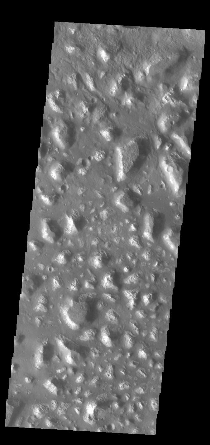
Cool image time! The Mars Odyssey science team today released the image on the right, cropped and rotated to show here, of a region on Mars named “Ariadnes Colles.”

The term colles means hills or knobs. The hills appear brighter than the surrounding lowlands, likely due to relatively less dust cover.

This is certainly a place with lots of hills, or to be more precise, mesas, as many of them seem to be flat topped.

The lack of dust cover on the tops is probably because, like on Earth, the winds blow much better once you get a bit above the surface. (This is why sailing ship builders kept adding higher and higher sails to their ships, until the top sails of clipper ships rose a hundred-plus feet above the deck.) These better winds clean off the mesa tops, just as they did to the solar panels on the rovers Opportunity and Spirit several times during their long missions.

Ariadnes Colles is another example of Martian chaotic terrain. Since this region is located deep in the cratered and rough southern highlands of Mars, the erosion that created these mesas was likely not water-flows. Was it wind? Ice?

Your guess is as good as anyone’s.

0 comments

A review of the Trump administrations’s SLS/Orion reprogramming options

Link here. This is a nice summary of the technical and political options being considered for the first unmanned Orion test flight, presently scheduled for June 2020, including replacing SLS with commercial launch rockets.

The article also noted that NASA is also looking at simplifying that test flight, because both SLS and Orion are behind schedule and this would make using a commercial rocket easier.

The currently baselined EM-1 [the test] mission would launch an uncrewed Orion spacecraft on a trans-lunar injection (TLI) trajectory; once released from the launch vehicle, it will fly solo for the first time. The Orion would then make two large engine burns to insert itself into a Distant Retrograde Orbit (DRO) around the Moon. Depending on the time of year, Orion would stay in the DRO for a half or one and a half orbits before making two more large engine burns to return to Earth. Preliminary analysis indicates a June, 2020, launch of the full-up mission would fall into the “long-class” category, with Orion staying in a DRO with a twelve-day long period for one and a half laps and flying a five-week long flight.

Prior to Administrator Bridenstine’s announcement of the alternate launch study for EM-1, notes passed to [this website] indicated that NASA Human Exploration and Operations Mission Directorate (HEOMD) Associate Administrator Bill Gerstenmaier had sent out a memo in early March indicating that studies to look at ways to keep the EM-1 launch in 2020 could not compromise any of the mission objectives; besides that, everything else was on the table.

The highest priority objective of the EM-1 mission is a lunar-velocity reentry test of the redesigned Orion heatshield, along with a full end-to-end test of the re-entry sequence and an in-space demonstration of Orion systems, many of which are flying for the first time.

Although Bridenstine’s public comments stressed flying EM-1 as a lunar orbit mission, there has been speculation that launching Orion out to near lunar distance without attempting either a lunar orbit or a lunar flyby could meet the highest priority objectives. Dropping the lunar orbit requirement or lunar flyby options would also relax launch opportunity constraints created by flying to the Moon and could perhaps reduce launch vehicle performance requirements enough to drop the [Earth orbit rendezvous] proposal and [docking] development work. [emphasis mine]

To use commercial rockets and still go into lunar orbit would require at least two commercial launches to get the required material up to orbit. It would also require developing Orion’s docking software now, something NASA had not planned to do until prior to Orion’s third flight several years hence. Avoiding lunar orbit means they can use a single Falcon Heavy launch and avoid these issues.

The highlighted phrase above indicates the most important priority of the test flight. This does not require lunar orbit. In fact, the Apollo mission tested its heat shield without leaving Earth orbit, and Orion can do the same.

It is still bothersome to read how haphazard NASA’s SLS/Orion program remains. They aren’t doing enough testing, their future flights are always in flux for political, schedule, and budgetary reasons, and they always seem to be in too much of a hurry to fly humans on very unproven vehicles. If NASA’s corrupt safety panel applied the same standards to SLS/Orion as it does to SpaceX and Boeing, the whole program would be shut down. It does not, because safety isn’t really its purpose. That panel’s goal is to serve NASA’s bureaucracy, and to protect its biggest projects (SLS/Orion) from any competition.

As for replacing SLS for that first Orion test flight, we shall see. The political forces opposing such a move are vast, and wield a lot of power.

9 comments

Confirmed: Ryugu is a rubble pile

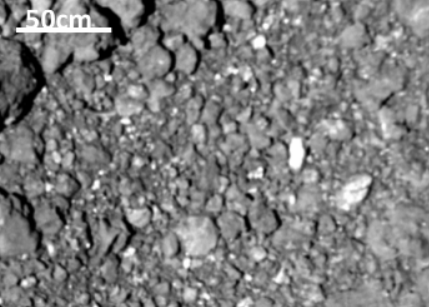
Close-up of Ryugu's surface
Click for source paper [pdf].

At a special session today dedicated to results from the Hayabusa-2 probe to the asteroid Ryugu at the 50th Lunar and Planetary Science Conference in Texas, scientists confirmed from numerous data and images that the asteroid has a low density, is covered with boulders and pebbles, is very porous, and is thus a rubble pile that is held together by gravity, barely.

From their lead presentation [pdf]:

The estimated total porosity is even higher than that of rubble-pile asteroid Itokawa (44 ± 4%), indicating that asteroid Ryugu is also a rubble pile. This is consistent with a theory arguing that all Solar System bodies with diameter of ~1 km should be rubble piles and might have formed from reaccumulation of fragments generated by catastrophic disruption events of ~100-km sized parent bodies.

They also posit that the asteroid’s diamond shape is caused by the asteroid’s 3.5 hour rotation, which causes its weak rubble pile structure to be easily pulled to the equator, and then outward.

Another paper [pdf] did crater counts, and found that there are fewer large craters than one would expect.

The density of large craters (D>100 m) on Ryugu is lower than the empirical saturation level and its slope is steeper than that of the saturated distribution, suggesting that craters larger than 100 m are not saturated and the size distribution reflects the crater production function. However, craters smaller than 100 m are significantly under-saturated, suggesting that some crater erasure processes such as seismic shaking and armoring effect are active on the Ryugu surface. Based on cratering chronology model for the main belt, the surface age of Ryugu is estimated to be 5–200 [million years] from the size–frequency distribution of craters larger than 100 m.

In other words, this rubble pile is constantly being shaken by its rotation and time and later impacts, which steadily rewrites the surface.

If this asteroid was headed to Earth, I imagine the only safe solution to prevent disaster would be to slowly and gently deflect it so it only flies past. To do this will require an arrival far in advance of the schedule impact, to give time for the deflection process to work.

5 comments

Snow on Mars?

Snow on Mars?
Click to see full image.

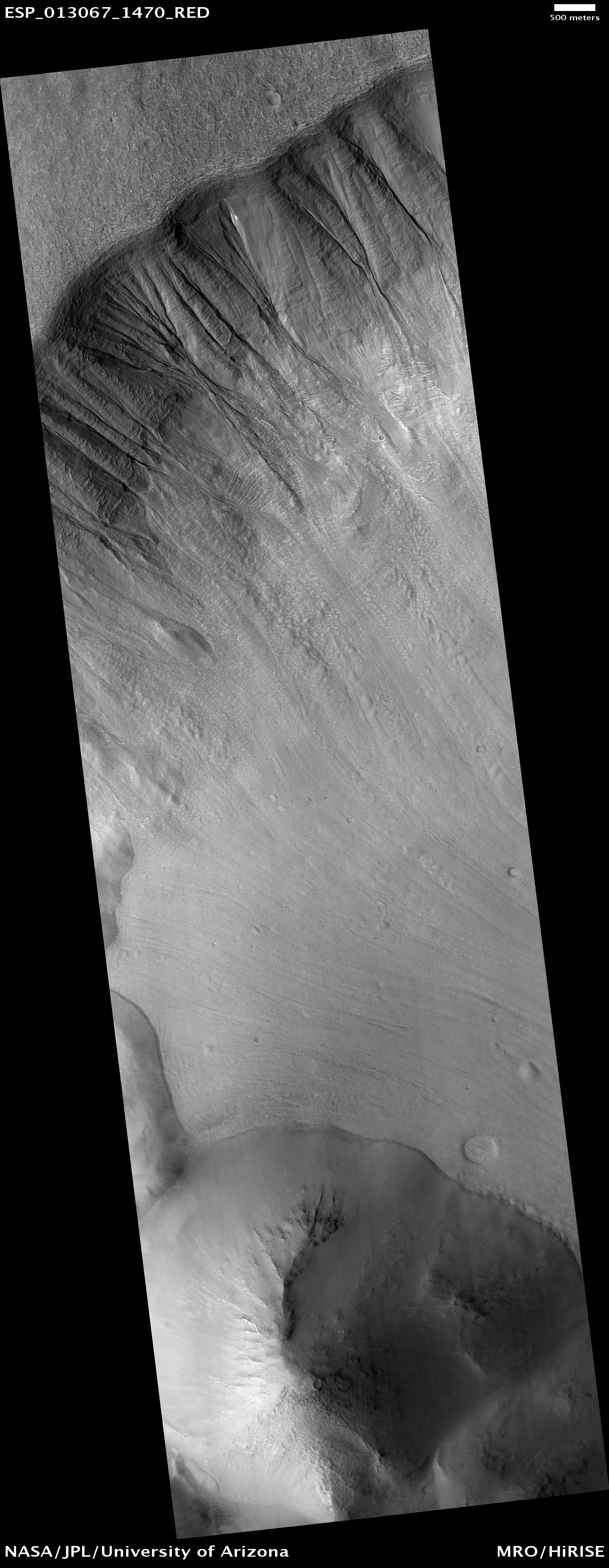
At today’s presentations at the 50th Lunar and Planetary Science Conference in Texas, scientists showed images and data [pdf] suggesting that many of the Martian gullies found on cliff faces are formed when the dust layer protecting underlying snow gets blown away and the exposed snow/ice then melts.

The image on the right was taken by the high resolution camera of Mars Reconnaissance Orbiter (MRO) in 2009, and has been cropped to post here. The white streaks are what they suggest is exposed ice/snow.

From their paper [pdf]
» Read more

0 comments

Test drone maps ice cave in Iceland

Engineers have tested a prototype lidar-equipped drone by flying it through a lava tube in Iceland and using it to automatically map the tube.

While a cave-exploring drone on Earth may use propellers, free-flying spacecraft exploring caves on the Moon, where there is practically no atmosphere, or in the thin air of high altitude lava tubes on Mars’ giant volcanoes, would have to use small thrusters. The mission of the terrestrial drone deployed at the Lofthellir Ice Cave focused on validating the idea of using a drone-equipped LiDAR to safely navigate and accurately map rock and ice inside a dark lava tube in the absence of GPS or any prior map.

Under a research contract with NASA, Astrobotic has developed a custom navigation software product, known as AstroNav, to give drones and small free-flying spacecraft the ability to autonomously explore and map subterranean environments. AstroNav employs both stereo vision and LiDAR, works without GPS or previously stored maps, and can operate in real-time while a novel environment is explored at a high rate of speed.

…”The Astrobotic drone and LiDAR performed exactly as we had hoped, and was able to help us map the Lofthellir Lava Tube in 3D within minutes” says Lee. “We now have a highly accurate model of the shape and dimensions of the cave, and of the configuration of its many rocky and icy features, such as rock falls, ice columns, and micro-glaciers.”

The concept is an excellent one, especially for exploring the caves and pits of Mars. This test however only checked out the lidar. A drone that could do this on either Mars or the Moon does not yet exist.

I have posted their video of the flight below the fold.

Note: Thanks to reader Eddie Willers for noting that I mistakenly located this research in Greenland, not Iceland. Post now corrected.
» Read more

3 comments

A rock on Bennu

A rock on Bennu
Click for full image (which is rotated 180 degrees).

Cool image time! The OSIRIS-REx science team today released a close-up image of the surface of the asteroid Bennu. The image on the right is a cropped and rotated section of that image, focusing on the image’s star, its largest rock.

The boulders on Bennu’s surface sport a variety of surface textures, from smooth, to hummocky, striated, and crumbly “cauliflower” in nature. The large boulder in the image center is ~92 ft (~28 m) across and has a somewhat round shape, though many smaller boulders surrounding it are very angular. Some of these appear to be fragments that may have disaggregated from the central boulder and display layering effects that may reflect some of the properties of their mineral composition. Other boulders show signs of surface exfoliation and fractures that may have been caused by impacts, mechanical weathering, and other forms of rock breakdown active on Bennu’s surface.

The image was taken from less than a mile away, and shows a spot near the asteroid’s south pole.

Why the larger boulder has a rounded look, but the pebbles around it are jagged, is a puzzle.

The science team also revealed today that they have detected plumes of particles being released from the asteroid’s surface. They have also found Bennu to present them with the same problem faced by the Hayabusa-2 team at Ryugu: The asteroid is far rougher than expected.

The higher-than-expected density of boulders means that the mission’s plans for sample collection, also known as Touch-and-Go (TAG), need to be adjusted. The original mission design was based on a sample site that is hazard-free, with an 82-foot (25-meter) radius. However, because of the unexpectedly rugged terrain, the team hasn’t been able to identify a site of that size on Bennu. Instead, it has begun to identify candidate sites that are much smaller in radius.

1 comment

Hayabusa-2 schedules explosion on Ryugu

The Hayabusa-2 science team has scheduled April 5 for when it will use the spacecraft to fire an explosive device into Ryugu to create a crater and debris cloud.

The probe is scheduled to detach a device loaded with explosives some 500 meters away from Ryugu. The device will set off the explosives using a timer some 40 minutes later and launch a copper “impactor” weighing about 2 kilograms into the asteroid’s surface.

The target point is several hundreds of meters away from where the space probe first touched down. The mission will require the spacecraft to move quickly to the other side of the asteroid so it won’t get hit by flying shards from the blast. A detached camera will shoot the moment of impact.

JAXA will analyze the size and shape of the crater, and how rocks fly off in a bid to collect underground samples for possible clues to the origin of the solar system.

This is different than the touchdown last month, as the spacecraft itself will not get close to the asteroid.

1 comment

Cost for Mars 2020 rover up 15%

Because of cost overruns in building three instruments for the Mars 2020 rover, its total budget will rise by 15%, forcing NASA to trim budgets elsewhere in its planetary program.

There are small efficiencies to be gained internally in Mars 2020, Glaze says, which, like its predecessor Curiosity, is being developed by NASA’s Jet Propulsion Laboratory (JPL) in Pasadena, California. Some work can be postponed, some timelines tightened; the end of the Opportunity rover, which expired late last year on Mars, will help. But it is expected the costs will largely be borne by trims to the operations of existing Mars missions and funds the agency sets aside for future missions, including the return of the rock samples that Mars 2020 will collect. “We tried to spread it so no one is feeling all of the pain,” Glaze says.

For a government program costing almost $2.5 billion, this overage is remarkably small. What is more significant is that the rover appears on schedule for launch in July 2020.

1 comment

Pink Floyd – Us and Them

A evening pause: Recorded live 1988. The song’s general hostility to war is an example of one of the greatest hallmarks of civilization. To make believe however that war is never necessary is to bow to those things that wish to destroy civilization, which is a most delicate thing.

Hat tip Mike Nelson.

PINK FLOYD – us and them – live delicate sound of thunder 1988 – YouTube from STEVE MCLEAN on Vimeo.

3 comments

Mars likely has many large and extensive cave systems

Mamers Valles

More caves on Mars! This week the Lunar and Planetary Institute and the Johnson Space Center are jointly holding the 50th Lunar and Planetary Science Conference in Texas. I have been going over the program, and will be posting reviews of some of the more interesting results all this week.

We begin with caves, which should not be surprising to my regular readers. As a caver who also knows their value for future space colonists, I am always attracted to new discoveries of cave passages on other worlds. Today’s however is a doozy.

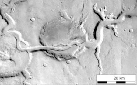
The image to the right is of Mamers Valles on Mars, what scientists have dubbed a fretted valley, a common feature in the transition zone between the low altitude northern plains and the southern highlands. It comes from a paper [pdf] with the typically unexciting scientific title, “Fretted channels and closed depressions in northern Arabia Terra, Mars: Origins and implications for subsurface hydrologic activity.”

What the scientists really means here is that their research strongly suggests that Mars has a very large and very extensive number of underground drainage systems, which have caused collapses on the surface that often resemble meandering river canyons, such as seen above. As they explain:
» Read more

3 comments
1 119 120 121 122 123 156