
More evidence that the rim of Shackleton crater is valuable real estate
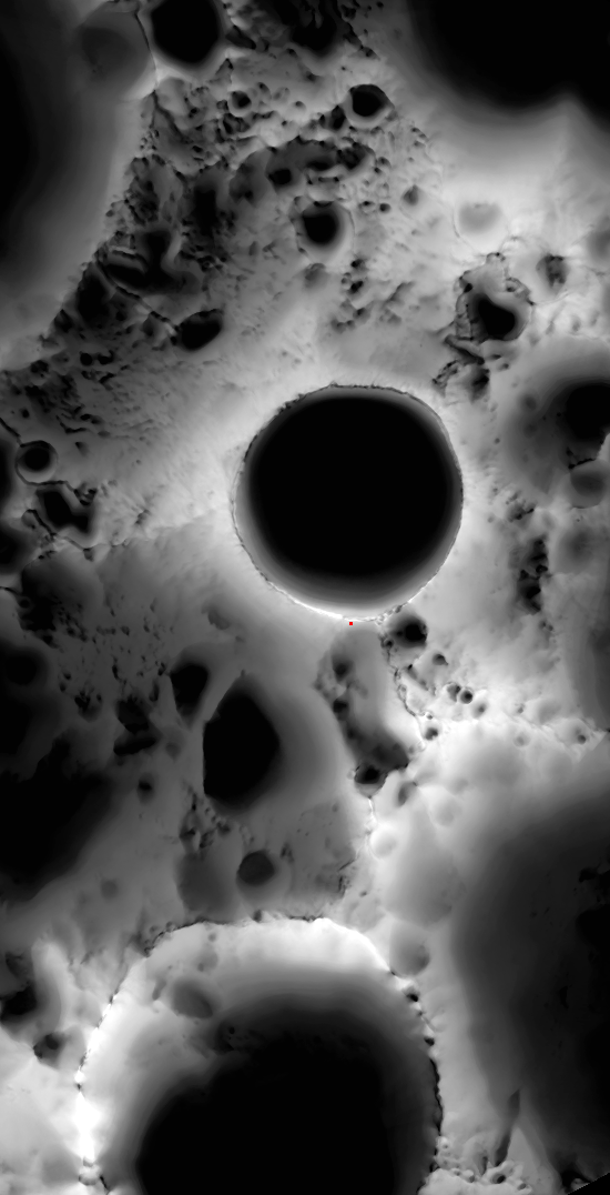
The image below was produced by Lunar Reconnaissance Orbiter by assembling data from numerous images over six months. The levels of brightness and darkness indicate the percentage of time in which an area is sunlight. The red dot just below the rim of Shackleton shows the approximate location of the south pole.
As you can see, the rim of Shackleton Crater nearest the south pole is illuminated by the sun most of the time, while the nearby crater floor never gets sunlight. This data confirms what Japanese scientists found using their lunar probe, Kaguya. The south pole has the ideal combination of locations with nearly continuous bright sunlight (to provide power) and nearly continuous darkness (where explorers will likely find significant amounts of frozen water), making this is an excellent location to build that first lunar base. And from the image you can see that the Shackleton Crater rim is not the only spot near the south pole with these conditions.
Also, if you look at the close-up image of Shackleton’s rim that I posted here, you will see that there is plenty of room to land and set up residence.

On Christmas Eve 1968 three Americans became the first humans to visit another world. What they did to celebrate was unexpected and profound, and will be remembered throughout all human history. Genesis: the Story of Apollo 8, Robert Zimmerman's classic history of humanity's first journey to another world, tells that story, and it is now available as both an ebook and an audiobook, both with a foreword by Valerie Anders and a new introduction by Robert Zimmerman.
The print edition can be purchased at Amazon or from any other book seller. If you want an autographed copy the price is $60 for the hardback and $45 for the paperback, plus $8 shipping for each. Go here for purchasing details. The ebook is available everywhere for $5.99 (before discount) at amazon, or direct from my ebook publisher, ebookit. If you buy it from ebookit you don't support the big tech companies and the author gets a bigger cut much sooner.
The audiobook is also available at all these vendors, and is also free with a 30-day trial membership to Audible.
"Not simply about one mission, [Genesis] is also the history of America's quest for the moon... Zimmerman has done a masterful job of tying disparate events together into a solid account of one of America's greatest human triumphs."--San Antonio Express-News
Beautiful image and will be useful and helpful. From 1700 images over 6 months, that’s about 1 images every couple hours!
Some issues that need to be considered are:
1) Light at the poles (this is the South Pole) is coming in nearly horizontally for a lot of the year. The surface dirt of the tops of hills or rims of craters may not be illuminated much (being nearly parallel to the Sun’s rays) even though light would fully illuminate an astronaut standing there or a solar array pointing at the Sun. The overlay method used to generate this image cannot address this issue. Look carefully at the image and you can see where this might be happening especially around the Shackleton Rim.
2) Dirt color. What if some of the dirt has different reflective properties than other parts? This would mess up the assumption of illumination. They assume some threshold of brightness to mean it is fully illuminated for the time step when generating this illumination map image.
3) Partial Sun blockage by terrain. The images cannot in any way quantify the low Sun on the horizon (for the polar regions this is of particular concern) being partially blocked by distant or nearby terrain. Just because it is lit up by their definition does not mean you are getting 100% Sun. Maybe only 25% Sun. Is the entire region or parts of it getting full Sun or half Sun? No way to know with these LRO snapshot images.
In summary, this illumination data must be taken with the above caveats and used in addition to the LRO laser altimeter digital elevation data and the LRO stereo imagery-derived digital elevation data to get the best assessment of illumination.
I’ld also add that a composit like this doesn’t tell you much about if there are large flat surfaces to land on. I expect you could have pretty serious bolders slops etc and have them not show up on this.
Though given we dumped all our plans to put a research station there its kind of moot?
Certainly I can’t see even more distent commercial lunar bases wanting to set up a base here?
This overlay/composite image is derived from the LRO WAC images, not the NAC ones. The WAC resolution is around 50-100 meters/pixel. NACs are around 0.5 to 5 m/pixel. So yes, this image cannot give slopes, but WACs really aren’t intended to do so. You can just take alot more images covering a large area with the WAC than you can the NAC and this helps do a time study of illumination. But the NAC resolution is good enough for understanding the slope, seeing boulders, fissures and deriving good stereo height models. Also, I think you could do a illumination overlay at this site using the NAC since the orbit causes alot more passes of the poles than elsewhere. But I tried overlaying just two NAC images with Photoshop and it brought my computer to its knees… they are just too big.
The LRO LOLA laser data can give some slope data too for where the laser hits (it cannot hit everywhere of course).
As to the activity being moot, not so. This kind of data was really needed at the beginning of Constellation and its lack slowed down our work. Without this kind of data, more conservative vehicles/bases needed to be designed and this may have made the architecture too heavy. Knowing the minimum continuous eclipse period helps size the energy storage mass, a significant part of the launch mass. So the data will be useful in the future if we restart this activity or if others choose to do so.