Mars rover update: June 23, 2017

Summary: Curiosity continues up hill. Opportunity has wheel problems.

Curiosity

For the overall context of Curiosity’s travels, see Pinpointing Curiosity’s location in Gale Crater.

The march up Mt Sharp continues. Since my last update on May 15, Curiosity has continued working its way up towards what the science team has named Vera Rubin Ridge, the beginning of a lighter, yellowish layer of rock, dubbed the Hematite Unit, that sits higher up the mountain’s slope. They have been traveling on the Murray Formation now for more than a year, since March, 2016, so entering this new layer of geology is eagerly anticipated by the science team. (This October 3, 2016 press release. gives an overall picture of the geology Curiosity is traversing.)

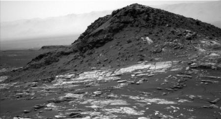
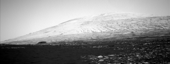
Reader Phil Veerkamp sent me a beautiful panorama he stitched together from recent Curiosity images of Vera Rubin Ridge, directly to the south of the rover and higher up hill. Below is a reduced resolution version. Be sure you click on it to explore the full resolution image. This is a new type of terrain, significantly different than anything Curiosity has seen up to now. It also appears that the rover will see far less dust, and might be traveling mostly over solid boulders. Below I have cropped out a very small section of the ridge line near the center of the full image, just to illustrate this.
» Read more
6 comments

Cumulative data from Curiosity shows Gale Crater lake stratified

The cumulative data from Curiosity since its arrival on Mars three and a half years ago shows that the lake that once filled Gale Crater lake had had a stratified chemical make-up.

Previous work had revealed the presence of a lake more than three billion years ago in Mars’ Gale Crater. This study defines the chemical conditions that existed in the lake and uses Curiosity’s powerful payload to determine that the lake was stratified. Stratified bodies of water exhibit sharp chemical or physical differences between deep water and shallow water. In Gale’s lake, the shallow water was richer in oxidants than deeper water was.

“These were very different, co-existing environments in the same lake,” said Joel Hurowitz of Stony Brook University, Stony Brook, New York, lead author of a report of the findings in the June 2 edition of the journal Science. “This type of oxidant stratification is a common feature of lakes on Earth, and now we’ve found it on Mars. The diversity of environments in this Martian lake would have provided multiple opportunities for different types of microbes to survive, including those that thrive in oxidant-rich conditions, those that thrive in oxidant-poor conditions, and those that inhabit the interface between those settings.”

While what Hurowitz says above is true, remember that this discovery provides zero evidence of past life on Mars. All it has done is teach us something about the different conditions in the lake at different depths.

0 comments

Curiosity data increases time water existed Gale Crater

New research using data from Curiosity has found evidence suggesting that significant water was present in Gale Crater for a very long time.

Lighter-toned bedrock that surrounds fractures and comprises high concentrations of silica — called “halos”— has been found in Gale crater on Mars, indicating that the planet had liquid water much longer than previously believed. The new finding is reported in a new paper published today in Geophysical Research Letters, a journal of the American Geophysical Union.

“The concentration of silica is very high at the centerlines of these halos,” said Jens Frydenvang, a scientist at Los Alamos National Laboratory and the University of Copenhagen and lead author of the new study. “What we’re seeing is that silica appears to have migrated between very old sedimentary bedrock and into younger overlying rocks. The goal of NASA’s Curiosity rover mission has been to find out if Mars was ever habitable, and it has been very successful in showing that Gale crater once held a lake with water that we would even have been able to drink, but we still don’t know how long this habitable environment endured. What this finding tells us is that, even when the lake eventually evaporated, substantial amounts of groundwater were present for much longer than we previously thought—thus further expanding the window for when life might have existed on Mars.”

The actual paper provides no time frame. What it does state is that for the halos to have formed requires a lot of time, and that during that time a lot of groundwater was required.

0 comments

Mars rover update: May 15, 2017

This update could also be entitled, “Up and down into Martian gullies,” as that is what both rovers, Curiosity and Opportunity, are presently focused on doing.

Curiosity

Curiosity's position, Sol 1696 (May 12, 2017)

For the overall context of Curiosity’s travels, see Pinpointing Curiosity’s location in Gale Crater.

In the past month, since my previous April 21, 2017 update, Curiosity has been working its way up the dry wash, frequently stopping to inspect the rocky surface terrain within. As they note,

As we climb up Mount Sharp, recently over slopes of 4-6 degrees, we have seen more varied outcrop structures and chemistries than the rest of the Murray formation, and such changes catch the collective eye of the team.

Only in the last week have they shifted to the east, as planned. Their near term goal is the lighter, yellowish layer of rock, dubbed the Hematite Unit, that sits higher up the slope of Mount Sharp. As they have been traveling on the Murray Formation now for more than a year, since March, 2016, I am certain the science team is even more eager to get to this different layer of geology to find out what it is made of and why it is there.

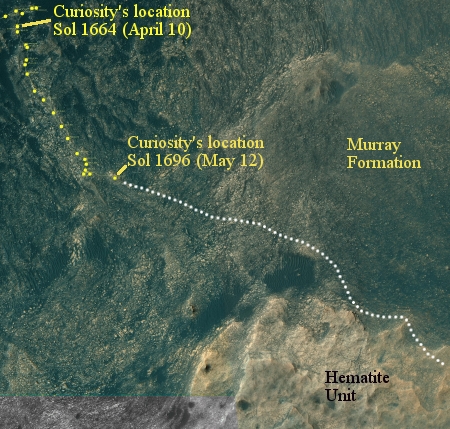
You can get an overall view of the geology Curiosity is traversing from this October 3, 2016 press release. Below is a version of the traverse map shown at that site that I posted as part of my October 6, 2016 rover update, updated to show Curiosity’s present location. It is apparent that Curiosity is finally moving out of the foothills below Mount Sharp and beginning its climb up the mountain’s actual slopes.
» Read more

5 comments

Curiosity’s last dune investigation

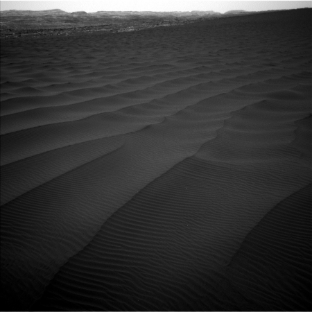
As Curiosity moves closer to the very base of Mount Sharp, it is presently making its last investigation of the various types of dunes found at the foot of the mountain.

From early February to early April, the rover examined four sites near a linear dune for comparison with what it found in late 2015 and early 2016 during its investigation of crescent-shaped dunes. This two-phase campaign is the first close-up study of active dunes anywhere other than Earth.

Among the questions this Martian dune campaign is addressing is how winds shape dunes that are relatively close together, on the same side of the same mountain, into different patterns. Others include whether Martian winds sort grains of sand in ways that affect the distribution of mineral compositions, which would have implications for studies of Martian sandstones. “At these linear dunes, the wind regime is more complicated than at the crescent dunes we studied earlier,” said Mathieu Lapotre of Caltech, in Pasadena, California, who helped lead the Curiosity science team’s planning for the dune campaign. “There seems to be more contribution from the wind coming down the slope of the mountain here compared with the crescent dunes farther north.”

The article also included a vague update on the status of Curiosity’s drill, out of commission since its drill feed mechanism had problems moving the drill up and down back in the fall of 2016.

Engineers are assessing how the use of vibration to deliver samples may affect the drill feed mechanism, which is used to move the drill bit forward and backwards. In addition, high winds at the linear-dunes location were complicating the process of pouring sample material into the entry ports for the laboratory instruments.

“A balky brake appears to be affecting drill feed mechanism performance,” said Curiosity Deputy Project Manager Steven Lee, of NASA’s Jet Propulsion Laboratory, Pasadena, California. “In some cases, vibration has been observed to change feed effectiveness, so we’re proceeding cautiously until we better understand the behavior. In the meantime, the engineering team is developing several methods to improve feed reliability.”

What this release does not say is whether they are any closer to solving the problem, or whether the drill is essentially out of business for the reminder of Curiosity’s life. To me, the silence on this question is deafening, and strongly suggests that they have decided the drill cannot be used, for the foreseeable future.

1 comment

Mars rover update: April 21, 2017

Curiosity

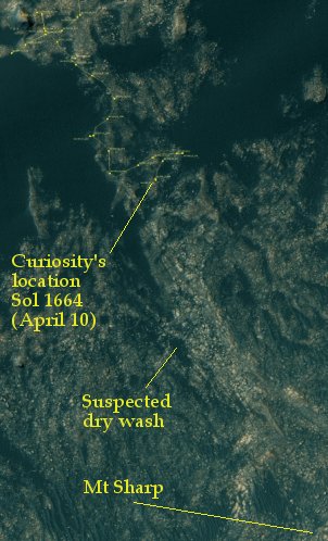
Curiosity's position, Sol 1664 (April 10, 2017)

For the overall context of Curiosity’s travels, see Pinpointing Curiosity’s location in Gale Crater.

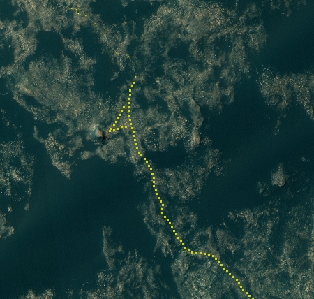
Since my previous February 14, 2017 update, Curiosity has worked its way through the dunes and has emerged, as planned at the head of what looks like a dry wash flowing down from Mount Sharp. At the time I had predicted that the science team would then have the rover make a beeline to Mount Sharp, following the smoothest route. That prediction is almost certainly wrong. Instead, the scientists are probably going to have the rover zig-zag its way south into the dry wash so that they can study the geology there. This is what they have been doing, as shown on the traverse map to the right, which shows Curiosity’s location through Sol 1664 (April 10). Ideally I expect them to want to check out the flow areas of the central parts of the wash as well as the contact point on either side where the color of the terrain changes from dark to light. This appears to be what they doing now, two weeks later, based on this update posted yesterday.

The 23 m drive on Sol 1673 put Curiosity alongside Murray bedrock blocks that appeared to be capped with a different material, with a darker color and smoother texture relative to the Murray

» Read more

1 comment

Mars rover update: February 14, 2017

Curiosity

Ireson Hill, Sol 1604

Dune fields

For the overall context of Curiosity’s travels, see Pinpointing Curiosity’s location in Gale Crater.

Taking a close look at rock

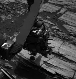
Since my last update in January, Curiosity done more or less what I predicted. It headed southwest through the dune area and then made a side trip to the small mesa there, dubbed Ireson Hill by the Curiosity science team and shown on the right. They then made an additional side trip past the hill to get a close look a the large sandy dune field beyond, also shown on the right. After getting some nice closeups as well as scooping up some sand for observation, they have now gone back to Ireson Hill to get another close look at the dark rocks that have rolled off the top of the hill and are now in reach at its base. The image on the left shows the arm positioned above one of those rocks.

The drill remains out of commission, with no word when they will try using it again. In addition, there had been a problem with the ChemCam laser that does spectroscopic analysis, but as of this week it is back in action, and is being used to analysis the small rock above.

Below is an overview of their route so far as well as my annotations on where I think they will be heading in the future.
» Read more

1 comment

Mars rover update: January 18, 2017

Curiosity

Curiosity's location, Sol 1582

For the overall context of Curiosity’s travels, see Pinpointing Curiosity’s location in Gale Crater.

In the past month, since my last rover update on December 22, 2016, Curiosity has begun moving again, carefully picking its way through the dune-filled flats in the foothills at the base of Mount Sharp. The route taken, shown on the image on the right, corresponds to the easternmost of the possible routes I noted in my November 14, 2016 update. This route is also the most direct route, which I think is smart considering that the rover’s life on Mars certainly uncertain and the higher they can climb the more geological information they will get.

I have also annotated the likely route into the near future, including a possible side trip to the base of the mesa up ahead. It appears to me that they are now a little more than halfway through the flats, with Mt. Sharp directly ahead, as shown by the panorama below, taken near the end of December. The goal is a canyon just out of view to the right of this panorama.

Looking at Mount Sharp

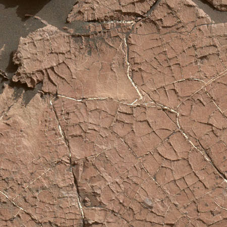
The flats the rover is presently traversing, and visible in the foreground of the panorama above, is strewn with dark sand that often piled into large sand dunes. Where the ground is exposed, it is made up of a scattering of pavement-like rocks. As noted in a press release yesterday, many of these flat rocks have polygonal cracks and boxwork similar to that seen in dried mud here on Earth, suggesting that this area was once wet and then dried. This geology helps confirm the theory of planetary scientists that Gale Crater was once filled with water that slowly evaporated away. As the rover climbs, it leaves the lakebed and begins to move through the lake’s various shores, each one older than the last.

Opportunity

For the overall context of Opportunity’s travels at Endeavour Crater, see Opportunity’s future travels on Mars.
» Read more

0 comments

Curiosity spots cracks formed from drying mud

mud cracks on Mars?

As Curiosity moves across the dust-shrewn dune-filled flats at the base of Mt. Sharp it has recently taken images of surface rocks that have cracks resembling those found from drying mud.

Scientists used NASA’s Curiosity Mars rover in recent weeks to examine slabs of rock cross-hatched with shallow ridges that likely originated as cracks in drying mud. “Mud cracks are the most likely scenario here,” said Curiosity science team member Nathan Stein. He is a graduate student at Caltech in Pasadena, California, who led the investigation of a site called “Old Soaker,” on lower Mount Sharp, Mars.

If this interpretation holds up, these would be the first mud cracks — technically called desiccation cracks — confirmed by the Curiosity mission. They would be evidence that the ancient era when these sediments were deposited included some drying after wetter conditions. Curiosity has found evidence of ancient lakes in older, lower-lying rock layers and also in younger mudstone that is above Old Soaker.

The rover is no longer on the floor the crater, but in the foothills at the base of Mt. Sharp. Thus, what we are likely looking at is evidence of the slow disappearance of the giant lake that scientists think once filled Gale Crater. These mud cracks suggest that the rover is now moving up out of the lake and through its margins.

I plan to do a rover update for both Curiosity and Opportunity tomorrow, so stay tuned.

0 comments

Curiosity looks at Mount Sharp

Looking at Mount Sharp

Cool image time! During the ten day holiday period, during which the Curiosity science and engineering teams generally got a break, they programmed the rover to take a variety of observations over the entire period. Some of those observations included repeated snapshots of the view ahead, using the rover’s navigation camera. The image above, reduced slightly from the full resolution image to show here, is one example of that view.

You can see the dark sandy dune region in the foreground, and the increasing steepness of the slope in the background. What I find most interesting are what look like canyon washes flowing downhill on the right, in what appear to be diagonally parallel cuts. That they do not flow directly downhill suggest to me that they were not created by water flow but by wind erosion, though it is possible that the geology of different bedding plains could have forced the flows in a diagonal direction down the slope. If wind erosion is the cause, however, it suggests a process that took a very long time to occur, as the atmosphere of Mars is so thin.

The route the rover will take is through a much larger canyon slightly off camera to the right. While the slope up the mountain on the left of the image appears to be an easier route, the geology there is not as interesting. Note also that we are not looking at the peak of Mount Sharp, which is much farther south and far higher.

7 comments

Mars rover update: November 14, 2016

Curiosity

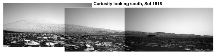
Curiosity looking south, Sol 1516

For the overall context of Curiosity’s travels, see Pinpointing Curiosity’s location in Gale Crater.

Since my last update on November 3rd, Curiosity has reached the region of sand dunes and has started to pick its way through it. The panorama above was created using images from the rover’s left navigation camera, taken on Sol 1516. It looks south, with Mount Sharp rising on the left.

That same day Curiosity also used its mast camera to zoom in on the canyon gap in the center of the panorama. The first image below is the wider mast camera shot, with the an outline showing the even closer zoom-in below that.
» Read more

1 comment

Mars rover update: November 3, 2016

Curiosity

Post updated: See last paragraph in Curiosity section.

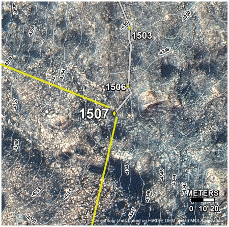
Curiosity location 1507

For the overall context of Curiosity’s travels, see Pinpointing Curiosity’s location in Gale Crater.

After spending almost a month on the flats south of Murray Buttes, during which the rover drilled another hole, in the past week Curiosity has finally resumed its journey south toward the slopes of Mount Sharp and the sand dune area that it must cross to get there.

Unfortunately, NASA has decided to change how it shows the rover’s progress, and these changes seem to me to be a clever and careful effort to make it more difficult for the public to make educated guesses about where the rover might be heading in the very near future. The image to the right is the cropped inset showing the rover’s recent travels that is part of a new a larger image that puts this inset in the context of the rover’s entire journey. This has replaced the wider orbital mosaic that they used to provide (see for example my September 27, 2016 rover update) that gave a very good view of the entire terrain surrounding the rover from which a reasonable estimate of its future path could be guessed.
» Read more

1 comment

Mars rover update: October 6, 2016

Curiosity

Post updated. See last paragraph of Curiosity section.

For the overall context of Curiosity’s travels, see Pinpointing Curiosity’s location in Gale Crater.

Curiosity looking west, Sol 1475

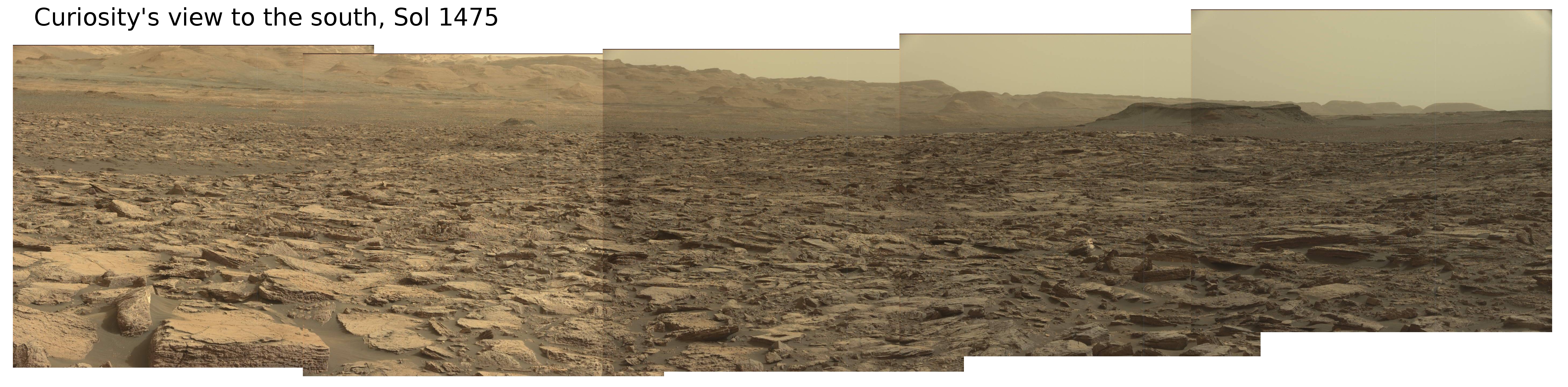
Having moved south from Murray Buttes, the Curiosity science team has decided [see Sol 1473] that they will veer the rover to the southwest a bit, partly to check out some interesting features but also I think as part of a long term plan to find the best route through an area of sand dunes that blocks their path to the more interesting landscape at the base of Mount Sharp. The panorama above, created by me from images taken by the rover’s mast camera on Sol 1475, was taken to scope out this route, and is indicated below the fold in the overview released earlier this week by the rover science team and annotated by me to indicate the direction of this panorama as well as the rover’s present location. (Be sure to click on the panorama above to see it at full resolution.)
» Read more

4 comments

Mars rover update: September 20, 2016

Opportunity comes first this time because it actually is more interesting.

Opportunity

For the overall context of Opportunity’s travels at Endeavour Crater, see this post, Opportunity’s future travels on Mars.

Having several choices on where to head, the Opportunity science team this week chose took what looks like the most daring route, heading almost due east towards the floor of Endeavour Crater. In fact, a review of their route and the images that the rover continues to take suggests that the panorama I created last week looked almost due east, not to the southeast as I had guessed. I have amended the most recent overhead traverse image, cropped and reduced below, to show what I now think that panorama was showing.
» Read more

1 comment

A Mars Rover Update

I have decided to continue my Mars rover updates, and make them a regular mid-week feature here on Behind the Black. This is the first.

Curiosity

For the overall context of Curiosity’s travels, see this post, Pinpointing Curiosity’s location in Gale Crater.

Since my last updates here and here, Curiosity has moved south through the gap between buttes to exit the Murray Butte area. The initial slopes of Mount Sharp lie ahead, an open road with no apparent rough terrain to slow travel.

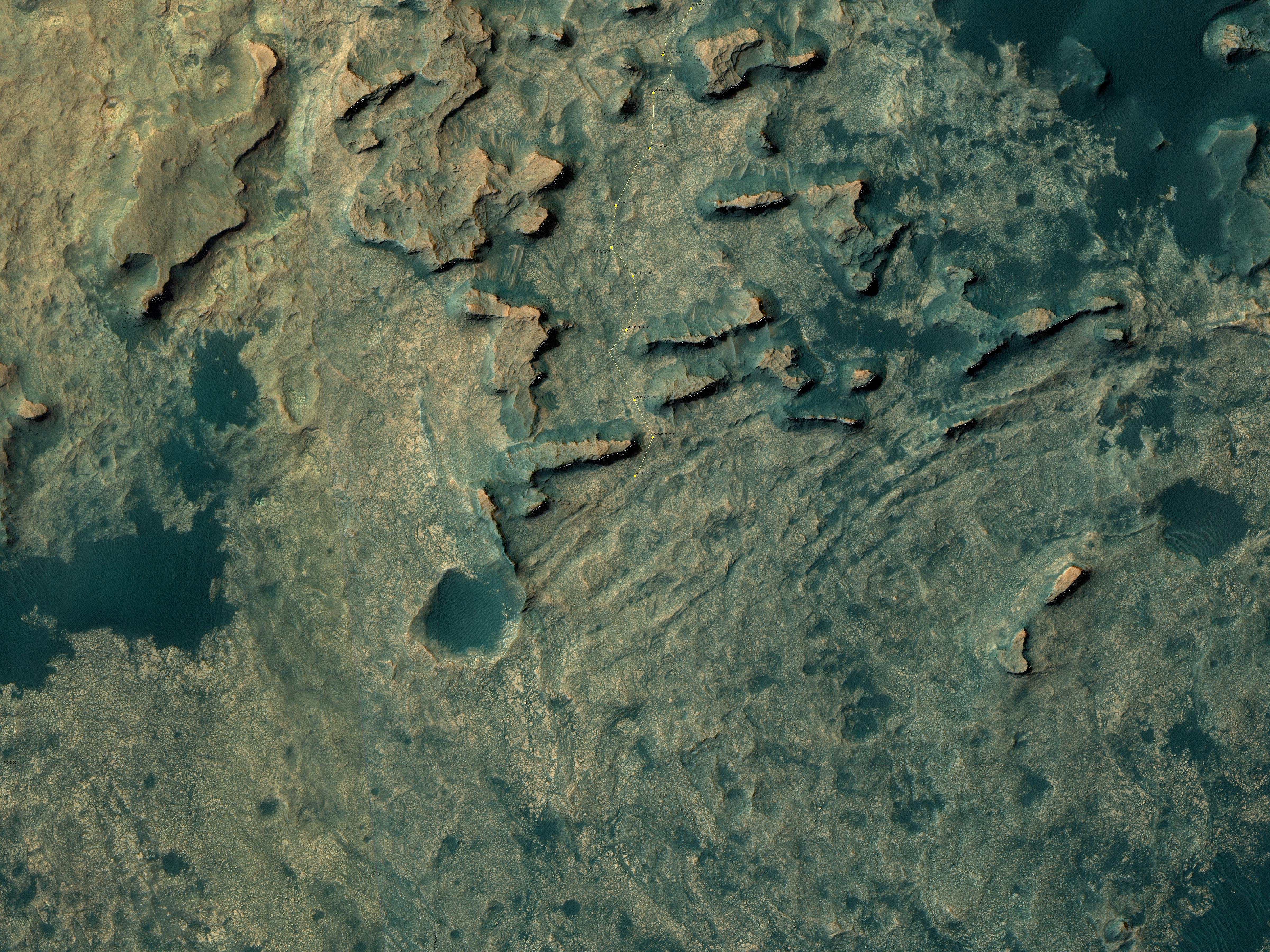
Doing science however does slow travel, and for good reason. Once through the gap the science team decided to swung the rover west and up against the base of the gap’s western butte, rather than immediately head south to climb the mountain. The Mars Reconnaissance Orbiter image below, cropped and reduced, illustrates this path.
» Read more

3 comments

New evidence suggest lake once existed in Gale Crater

Scientists have concluded that mineral veins seen by Curiosity in Gale Crater were created when a lake existed there.

The study suggests that the veins formed as the sediments from the ancient lake were buried, heated to about 50 degrees Celsius and corroded. Professor John Bridges from the University of Leicester Department of Physics and Astronomy said: “The taste of this Martian groundwater would be rather unpleasant, with about 20 times the content of sulphate and sodium than bottled mineral water for instance!”

3 comments

Route to Balanced Rock

Route to Balanced Rock on Mars

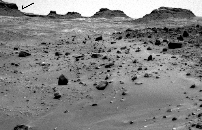
The image above is a panorama I have created from the raw images taken by Curiosity’s left navigation camera today, using this image for the left half and this image for the right half. They show the terrain in front of the rover, including the balanced rock on the horizon, indicated by the arrow.

I have no idea what route the science team plans, but looking at all of the images, as well as their desire to get a closer look at the rock, I suspect they will head up to the left on the smoother ground, aiming almost directly at the balanced rock. I also suspect that they will eventually veer right before getting to the rock, since the rover can’t go over the rough terrain in that area. Stay tuned to find out.

4 comments

Curiosity heads south

After four years of southwest travel to skirt a large dune field at the base of Mount Sharp, Curiosity has finally turned due south to aim directly up the mountain.

“Now that we’ve skirted our way around the dunes and crossed the plateau, we’ve turned south to climb the mountain head-on,” said Curiosity Project Scientist Ashwin Vasavada, of NASA’s Jet Propulsion Laboratory, Pasadena, California. “Since landing, we’ve been aiming for this gap in the terrain and this left turn. It’s a great moment for the mission.”

1 comment
1 9 10 11 12 13