
Video from inside the Washington Monument during the August 23, 2011 5.8 magnitude earthquake
The National Park Service has now released security camera videos from inside the Washington Monument during the August 23, 2011 5.8 magnitude earthquake.
The National Park Service has now released security camera videos from inside the Washington Monument during the August 23, 2011 5.8 magnitude earthquake.
An evening pause: Hiking Pu’u Kalena, the second highest peak on the island of Oahu, Hawaii.
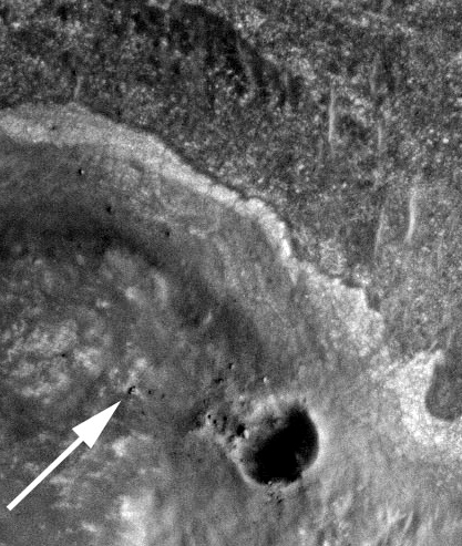
The image to the right was taken by Mars Reconnaissance Orbiter, with the white arrow showing the Mars rover Opportunity perched on the rim of Endeavour Crater.
The rover’s scientists hope that the rocks found on the crater rim, dredged up from deep below when the crater impact occurred, will be the oldest rocks so far touched on the Martian surface, and thus give them a peek at ancient Martian geology.
Farmers begin fleeing as Indonesia’s Mount Tambora volcano comes back alive.
Villagers like Hasanuddin Sanusi have heard since they were young how the mountain they call home once blew apart in the largest eruption ever recorded — an 1815 event widely forgotten outside their region — killing 90,000 people and blackening skies on the other side of the globe. . . . The April 1815 eruption of Tambora left a crater 7 miles (11 kilometers) wide and half a mile (1 kilometer) deep, spewing an estimated 400 million tons of sulfuric gases into the atmosphere and leading to “the year without summer” in the U.S. and Europe.
The story behind the Italian prosecution of six scientists and one government official over their failure to make an earthquake prediction.
As is usual in these kinds of stories, things are more complicated than they appear at first glance.
The science team of Lunar Reconnaissance Orbiter released an intriguing picture yesterday of what scientists call a granular flow down the side of a five mile wide crater on the far side of the moon. Looking at the image, one would swear that the darker material flowing down the slope of the crater rim is a lava flow frozen in place.
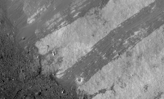
However, according to the scientists, that is not what it is. Instead, this is merely debris left behind from an avalanche.
» Read more
The geology behind the Virginia earthquake of August 23. And an even better analysis, with maps, can be found here.
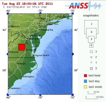
A 5.9 magnitude earthquake hit Virginia at about 1:51 pm (Eastern).
I am in Maryland, just outside the beltway, and felt something like an earthquake about five minutes ago. The house started to shake, then settled, then shook again. Quite startling. I opened the front door the same time a neighbor did. She had felt the same thing.
The above quake was more than 90 miles away. I wonder how bad it is there, considering the eastern U.S. rarely experiences quakes and has made no preparations for such a thing.
For updates:
» Read more
Below the fold are two images released today, one from Dawn at Vesta and the other from Messenger at Mercury. What makes them interesting to me is that, though the surfaces of both Vesta and Mercury are crater-packed, there are definitely distinct differences between them that one can spot if you look closely, all highlighting the fundamentally different environments of both worlds.
First, the Vesta photograph. The image looks out past the asteroid’s horizon, showing clearly that this dwarf planet is not spherical, with the south pole depression that puzzles scientists just on the planet’s limb. The parallel long deep grooves that are associated with this depression can be seen on the right. Notice also that the inside walls of all the craters slope downward in a very shallow manner. This gives the impression that the impacts that formed these craters smashed into an almost beachlike sandy surface. Note too the that the center of some craters have what appear to be flat small “ponds,” a phenomenon seen by the spacecraft NEAR when it orbited the asteroid Eros. These ponds are not liquid, but are actually made up of fine-grained particles that settle in the hollows of the asteroid.
» Read more
Japan has revised its tsunami warning system following the March 11 earthquake/tsunami.
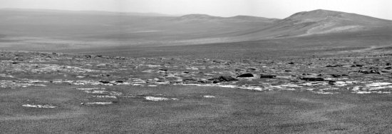
The science team for the rover Opportunity have released their first image taken from the rim of Endeavour Crater.
Since this picture looks south from Spirit Point less than a football field’s distance from the rim, it appears to look into the crater, the mountains on the right being the crater’s rim. What looks like a debris field running across the center of the image looks to me to be a combination of exposed patches of bedrock and boulders on the plateau above the rim. For the scientists, those boulders will be the prime research targets, as they are possibly ejecta produced at crater impact and could therefore be material thrown out from deep within the Martian crust.
Satellite data has confirmed that the March 11 Japanese tsunami caused icebergs to calf off the Sulzberger Ice Shelf in Antarctica.