Jupiter’s southern jet streams

Jupiter's southern jet streams
Click for full image.

Cool image time! The photo to the right, rotated and reduced slightly to post here, shows the southern jet streams in Jupiter’s atmosphere. From the press release:

The storm known as the Great Red Spot is also visible on the horizon, nearly rotated out of view as Juno sped away from Jupiter at about 30 miles per second (48 kilometers per second), which is more than 100,000 mph (160,900 kilometers per hour).

Citizen scientist Tanya Oleksuik created this color-enhanced image using data from the JunoCam camera. The original image was taken on Dec. 30, 2020 as the Juno spacecraft performed its 31st close flyby of Jupiter. At the time, the spacecraft was about 31,000 miles (about 50,000 kilometers) from the planet’s cloud tops, at a latitude of about 50 degrees South.

According to data obtained by Juno, these bands of storms extend about 1,800 miles into Jupiter’s interior, much deeper than expected.

The Great Red Spot is at about 22 degrees south latitude, so this tells us that this picture covers Jupiter’s southern hemisphere from about the equator down to about 80 degrees.

Turkey to do lunar mission, send astronaut into space

The new colonial movement: Turkey’s leader, Tayyip Erdogan, announced yesterday a new space exploration initiative that will include sending an unmanned probe to the Moon as well as flying an astronaut into space.

“The first rough landing will be made on the moon with our national and authentic hybrid rocket that shall be launched into orbit in the end of 2023 through international cooperation,” Erdogan said, detailing a two-phase mission. Erdogan did not elaborate further on the cooperation. Last month, Erdogan spoke to Tesla and SpaceX boss Elon Musk on possible cooperation in space technologies with Turkish companies.

Speaking in an event in Ankara, Erdogan announced a programme with 10 strategic goals including sending a Turkish citizen to a scientific mission in space.

The manned mission will not be flown by Turkey, but will be purchased from someone else, either Russia or SpaceX or Boeing maybe even China.

The timing of this announcement, the same day the UAE’s Al-Amal probe entered Mars’ orbit, suggests it was prompted by that success, and is an example of keeping up with the Joneses. Whether there is any reality to these proposals however remains to be seen.

China’s Tienwen-1 enters Mars orbit

The new colonial movement: China’s Tienwen-1, carrying an as-yet-unnamed lander/rover, successfully inserted itself into orbit around Mars early today.

With a successful Mars Orbit Insertion, the craft has entered a highly eccentric, equatorial capture orbit of the planet, and controllers will now spend two months undertaking initial activations and checkouts in Martian orbit for the primary science mission while altering the craft’s orbit from equatorial to polar.

In April 2021, the lander, with the rover inside, will detach from the orbiter and prepare for Entry, Descent, and Landing. Prior to launch, 23 April 2021 was given as the target landing date.

The landing location is within Utopia Planitia and will — if the orbit insertion burn is completed successfully — utilize a combination of aerobraking, parachute descent, retrorocket firing, and airbag deployments to achieve a soft touchdown on the Martian surface. After landing, the rover will be deployed — ideally on the same day — to begin a planned 90 Sol (Martian day) mission to categorize the local environment.

The suspected landing site in Utopia Planitia is at about 25 degrees north latitude. Though it is in the northern lowland plains, this latitude places it south of the latitudes (greater than 30) that scientists now believe ample ice likely exists underground but accessible. The lander/rover carries radar equipment capable of detecting evidence of underground ice, and will look nonetheless. If it finds any, this will be a significant discovery.

Two down, one to go. Next week, on February 18th, the American rover Perseverance will attempt its landing in Jezero crater.

Another “What the heck?!” image on Mars

A
Click for full image.

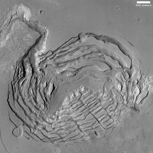
Today’s cool image, taken on September 2, 2020 by the high resolution camera on Mars Reconnaissance Orbiter (MRO) and cropped and reduced to post here, is one that I will make very little attempt to explain. It falls into a category I call “What the heck?!” The uncaptioned website labels this “Ringed Ridges in Kasei Valles”, which merely describes what we see.

This isn’t an impact crater. The rings don’t fit any morphology I’ve ever seen for such features.

Could we be looking at some type of glacial feature? The latitude, 29 degrees north, makes this unlikely but possible. Even so, it sure doesn’t look like it. The ripples in the center and between the ridges are sand dunes, not glacial features.

Might this be a volcanic vent, with the concentric ridges marking multiple eruptions? Maybe, but if so I’ve never seen any volcanic vent or caldera that looked quite like this.

The overview map below gives some context, but hardly explains anything.
» Read more

Sunspot update: January activity returns to expected levels

Though I am a bit late this month, it is once again time provide my monthly update of the Sun’s on-going sunspot cycle. Below is NOAA’s February 1, 2021 monthly graph, showing the Sun’s monthly sunspot activity. I have, as I do each month, annotated it to show the previous solar cycle predictions.

After two months of relatively high activity, activity that was very high so early in the ramp up to solar maximum, the number of sunspots in January dropped down to closely match the predicted value. It was still higher, but not by much.

» Read more

Fiftieth anniversary of Apollo 14 lunar landing

Apollo 14 as seen by LRO
Click for full image.

In honor of the fiftieth anniversary today of the landing of Apollo 14 on the Moon, the Lunar Reconnaissance Orbiter (LRO) science team has used images from the spacecraft to map out what the astronauts did on the surface, as shown in the reduced image to the right. The orange and teal lines indicate the routes followed during the two EVAs, with the pink triangles indicating stopping points along the way.

Unlike Apollo 11 and 12, which focused on engineering goals such as landing precisely on the Moon, Apollo 14 focused on addressing science goals. Antares (lunar module) landed in the Fra Mauro highlands, the original destination of the failed Apollo 13 mission, essentially taking on that mission’s objectives. This was the first crewed landing in the lunar highlands and not in the mare.

The Apollo 14 astronauts who landed on the Moon, Alan Shepard (Commander) and Edgar Mitchell (Lunar Module Pilot), completed two extra-vehicular activities (EVAs) while on the surface. They spent a total of 9 hours and 22 minutes setting up equipment, taking photographs, collecting samples, and exploring.

This was the last mission where the astronauts had to walk. The next three Apollo missions brought a rover with them, so that they could drive to their research sites.

Musk: Starlink to go public once operational

Capitalism in space: According to a tweet by SpaceX founder Elon Musk, once the Starlink internet satellite constellation is operational and has a “reasonable well” cash flow it will issue and IPO and become a publicly traded stock.

“SpaceX needs to pass through a deep chasm of negative cash flow over the next year or so to make Starlink financially viable,” Musk wrote in another tweet. “Every new satellite constellation in history has gone bankrupt. We hope to be the first that does not.”

Based on the company’s pace of launching satellites and rolling out service, this moment could occur as early as late this year. More likely it will occur in mid-22.

I would also expect that stock to quickly rise in value, and based on the history of all of Musk’s companies, will continue to rise thereafter. Expect also that a significant portion of the investment capital that Starlink will raise will be used to finance the development of Starship and Super Heavy, because Starlink will need that larger rocket to maintain its satellite constellation.

UAE’s Hope or Al-Amal Mars Orbiter orbital insertion

UPDATE: The probe has apparently achieved orbit.

The new colonial movement: The United Arab Emirates’ (UAE) Mars orbiter, Hope, or Al-Amal in Arabic, is about to insert itself into orbit around the red planet, with that insertion to be confirmed by 11:08 (Eastern).

If you want to watch, I have embedded the live stream below the fold. A warning: The insertion is a relatively interesting event to watch, as the orbiter works autonomously and the signal confirming it happened arrives after the event. Most of the stream is propaganda for the UAE.
» Read more

OSIRIS-REx has begun its return to Bennu

On January 14th the OSIRIS-REx team fired the spacecraft’s engines to halt its drift away from the asteroid Bennu and begin its return for one last reconnaissance before heading to Earth with its samples.

OSIRIS-REx executed the first maneuver on Jan. 14, which acted as a braking burn and put the spacecraft on a trajectory to rendezvous with the asteroid one last time. Since October’s sample collection event, the spacecraft has been slowly drifting away from the asteroid, and ended up approximately 1,635 miles (2,200 km) from Bennu. After the braking burn, the spacecraft is now slowly approaching the asteroid and will perform a second approach maneuver on Mar. 6, when it is approximately 155 miles (250 km) from Bennu. OSIRIS-REx will then execute three subsequent maneuvers, which are required to place the spacecraft on a precise trajectory for the final flyby on Apr. 7.

OSIRIS-REx is scheduled to depart Bennu on May 10 and begin its two-year journey back to Earth. The spacecraft will deliver the samples of Bennu to the Utah Test and Training Range on Sep. 24, 2023.

While they will gather images of the whole asteroid, their number one goal will be to get high resolution photos of the sample-grab site Nightingale to see how it was changed by that sample grab. The spacecraft pushed into the asteroid’s rubble pile about 1.6 feet, and that act certainly disturbed both the interior and surface. By comparing the before and after pictures scientists can garner a lot of information about the asteroid’s make-up, density, and structure. It will also teach future engineers what to expect when next they try to touch another rubble-pile asteroid.

The Icy Surface of Mars

The extent of ice on Mars

Two newly published science papers in the past few days have once again reinforced the growing evidence that much of Mars from 30 degrees latitude to its poles is very icy, with much of that ice found close to the surface.

The map above, adapted and annotated by me from figures 4 and 12 of one of those papers (“Widespread Exposures of Extensive Clean Shallow Ice in the Mid‐Latitudes of Mars”), show the areas on Mars where the evidence suggests ample and easily accessible ice, underground but close to the surface.

The red dots and diamonds indicate recent impact craters that temporarily exposed the underground ice layer that would normally not be visible. The white dots and diamonds indicate ice scarps with visible ice layers in their cliff faces. The size of these locations is greatly exaggerated.

The two hatched lines at 30 degrees latitude, north and south, indicate the closest to the equator that scientists have detected evidence of glacial ice. It is also the closest to the equator that the second new paper, “Water Ice Resources Identified in Martian Northern Hemisphere “, has found evidence of underground ice in the north. From the abstract of this second paper:
» Read more

Hydrazine on the surface of Saturn’s moon Rhea?

The uncertainty of science: Scientists using data from several Cassini flyby’s of the Saturn moon Rhea now think that hydrazine, a very toxic chemical routinely used by spacecraft as fuel, might exist on its surface.

Their effort was an attempt to identify an unknown spectroscopy absorption feature at a specific wavelength.

In comparison to chloromethane, the production of hydrazine monohydrate was easier to explain due to chemical reactions involving water-ice and ammonia or delivery from Titan’s nitrogen rich atmosphere. Elowitz et al. considered the possibility of contamination of the UVIS data by a hydrazine propellant from the Cassini spacecraft, although it was highly unlikely since the hydrazine thrusters were not used during icy satellite flybys.

The team confirmed the specific signature of a 184-nm feature on Rhea’s surface using the UV spectrometer observations made by the Cassini spacecraft. In addition to that, the irradiation of ammonia by charged particles from Saturn’s magnetosphere induced the dissociation of ammonia molecules to form diazene and hydrazine. The source of ammonia on Rhea could be primordial, incorporated into its interior during formation and brought to the surface within a period of endogenic activity, as evident in Cassini ISS imagery, although ammonia was unlikely to survive indefinitely on the surface. The team suggest further analysis to understand the potential for satellite-to-satellite transfer of materials across Titan’s atmosphere to explain the presence of hydrazine monohydrate on Rhea.

Though useful as a fuel, its poisonous nature will make any exploration of these moons very hazardous, and will also likely make its usefulness difficult initially in that exploration

Betelgeuse is closer and smaller than previously thought

Betelgeuse's fading
Images taken by Europe’s
Very Large Telescope in Chile

The uncertainty of science: A new analysis by scientists of Betelgeuse, triggered by its dip in brightness in 2020, has concluded that the red giant star is both closer and smaller than previously estimated.

Their analysis reported a present-day mass of 16.5 to 19 solar mass—which is slightly lower than the most recent estimates. The study also revealed how big Betelgeuse is, as well as its distance from Earth. The star’s actual size has been a bit of a mystery: earlier studies, for instance, suggested it could be bigger than the orbit of Jupiter. However, the team’s results showed Betelgeuse only extends out to two-thirds of that, with a radius 750 times the radius of the sun. Once the physical size of the star is known, it will be possible to determine its distance from Earth. Thus far, the team’s results show it is a mere 530 light years from us, or 25 percent closer than previously thought.

The research also suggested that the star is in the initial stages of burning helium rather than hydrogen, and so it likely more than 100,000 years from going supernova.

As for the dimming, the scientists concluded (as other have) that the dimming in ’20 was due to the passage of a dust cloud in front of the star.

The new invasion of Mars begins next week!

In the next two weeks three spacecraft will arrive at Mars, including two orbiters and two rovers. This post is simply a heads up so that my readers will know what to expect and when to expect it.

First, we have the arrival in Mars orbit of the United Arab Emirates’ (UAE) Hope orbiter on February 9th at 10:30 am (Eastern). The spacecraft was built in a partnership with U.S. universities and the UAE. Once in orbit it will focus on studying the Martian atmosphere.

Next will arrive China’s Tianwen-1 orbiter on February 10th. The exact time it will do its engine burn to enter orbit has not been announced, as far as I can tell. Once in orbit it will begin a four month reconnaissance of the landing site for its presently unnamed rover, which will descend to the surface in May.

Finally, on February 18th at 12:55 am (Pacific) the American rover Perseverance will land in Jezero Crater on Mars. Essentially an upgraded copy of the Curiosity rover, it will land in the same way, lowered by cables from its re-entry sky crane rocket above it. It will then spend years studying the geology of Mars, while also storing samples that a later mission can recover and return to Earth.

All in all February is going to be an exciting month for the exploration of Mars. Stay tuned for some cool stuff!

New theory to explain the Martian seasonal streaks

The uncertainty of science: Scientists have proposed a new explanation for explaining the Martian seasonal streaks called recurring slope lineae that appear each spring and then fade over time.

Lineae, while unique to Mars, are different than the other similar Martian feature called slope streaks, which are not seasonal and have a somewhat different appearance and morphology.

This new proposal refines some of the past ideas for the seasonal cause of lineae.

Previous ideas suggested that liquid debris flows or dry granular flows caused this movement. Neither model can completely account for the seasonal martian flow features known as Recurring Slope Lineae (RSL). The team alternatively hypothesizes that small-scale ice melting in the near-surface regolith is causing changes at the surface that make it vulnerable to dust storms and wind. As a result, the RSL features appear and/or expand on the surface of Mars today. Further, the team believes that the thin layers of melting ice result from interactions between underground water ice, chlorine salts, and sulfates, which create an unstable, liquid-like flowing slush instigating sinkholes, ground collapse, surface flows, and upheave.

…Previous studies have suggested RSL are related to chlorine salts and noted their occurrence in regions of high sulfate outcrops. The current study extends these observations with a near-surface cryosalt activity model based on field observations and lab experiments. However, the exact mechanism of RSL formation on Mars still remains a mystery. [emphasis mine]

The mainstream press will make a big deal about this, but it really does nothing but add some nuance to previous theories. We really still do not know what causes lineae, as the highlighted text above notes.

Ten finalists in public Chinese contest to name Mars rover

The new colonial movement: The Chinese public vote to pick the name of the Mars rover presently flying to Mars on its Tianwen-1 orbiter has now been narrowed to ten finalists.

The public can now vote for their favorites from a shortlist of 10 names for the Tianwen-1 mission rover.

The 10 names — Hongyi, Qilin, Nezha, Chitu, Zhurong, Qiusuo, Fenghuolun, Zhuimeng, Tianxing and Xinghuo — are taken from ideas including Chinese mythological figures, Confucian concepts and legendary animals.

Notably Hongyi, from the Confucian Analects, can be translated to “persistence” or perseverance, giving a similar meaning to the NASA Perseverance rover also heading for Mars. Others meanings include:

Zhurong: a god of fire
Qilin: a Chinese unicorn
Chitu: red rabbit
Qiusuo: to explore, referencing an ancient poem
Zhuimeng: to pursue a dream
Nezha: a mythological hero
Fenghuolun: Nezha’s weapons
Tianxing: referring to the motion of celestial bodies
Xinghuo: spark

Personally, I hope they pick Chitu (Red Rabbit), as that matches nicely with the name of China’s lunar rover, Yutu-2 (Jade Rabbit).

More weird features and changes on Mars

Some strange stuff on Mars
Click for full 2020 photo.

Overview map

Cool image time! The photo to the right, rotated, cropped, reduced, and annotated to post here, was taken on September 28, 2020 by the high resolution camera on Mars Reconnaissance Orbiter (MRO). Uncaptioned and labeled “Reticulate Bedform Change Detection on Arsia Mons West Flank,” it shows a whole bunch of strange features in addition to a change that occurred sometime in the past two years.

I think it also well illustrates in one image how alien Mars is.

The main features in this photo are what scientists have dubbed reticulate bedforms. These features, found mostly in the high elevations on the flanks of the giant volcanoes in the Tharsis Bulge to the west of Valles Marineris, are thought to be ancient dunes made of volcanic dust and debris that has solidified into an aggregate. These dunes are found with a variety of patterns.

Aggregates on the flanks are transported downslope by katabatic winds and form linear and “accordion” morphologies. Materials within the calderas and other depressions remain trapped and are subjected to multidirectional winds, forming an interlinked “honeycomb” texture. In many places on and near the volcanoes, light-toned, low thermal inertia yardangs and indurated surfaces are present.

The photo to the right appears to show all three patterns, even though it is located on the northwestern slopes of of Arsia Mons, the southernmost of the string of three giant volcanoes in the Tharsis Bulge. On the overview map to the right, this photo’s location is indicated by the white box. The black boxes indicate the location of all the pits caves that surround Arsia Mons which I have previously posted about on Behind the Black.

It is intriguing that, at least at this point, these particular reticulate bedforms on the slopes of Arsia Mons happen to be in a region where few cave pits have so far been identified. It could be that the conditions that form each are mutually exclusive. If you get pits on the slopes of Martian volcano you can’t have reticulate bedforms. Or maybe not all the pits have yet been located, or the flanks of the volcano has many more reticulate bedforms that I simply have not documented.

Either way, this particular cool image has two areas of interest, as noted by the white boxes above.
» Read more

India is targeting ’21 for first unmanned test launch of manned system

The new colonial movement: According to Indian government officials, the first unmanned test flight of their Gaganyaan manned capsule will occur before the end of 2021.

The first unmanned launch is slated for December 2021. The Gaganyaan is a crewed orbital spacecraft expected to carry three astronauts into space for at least seven days. The spacecraft is likely to consist of an orbital module which will have a service and a crew module. The mission is estimated to cost around Rs 10,000 crore. The GSLV Mk-III, now called LVM-3 (Launch Vehicle Mark-3), will be deployed for the launch.

The new name for the rocket helps distinguish it from the GSLV Mk-II, a smaller version aimed mostly at commercial customers.

India also hopes to launch a new smallsat rocket in ’21, as well as its next lunar lander/rover, Chandrayaan-3. The country’s space effort will also be attempting to recover from its shutdown in 2020 due to the Wuhan virus panic.

NASA delays lunar lander contract award

NASA, now under the control of the Biden administration, has quietly delayed by at least two months the contract award to two companies to build manned lunar landers for its Artemis program.

With short funding from Congress and a new administration focused on more pressing national issues, the move was expected.

Elon Musk’s SpaceX, a team of aerospace giants led by Jeff Bezos’ Blue Origin, and Leidos-owned Dynetics won a combined $967 million in seed funding from NASA last year to develop rivaling concepts for a human lunar landing system. It’s the space agency’s first effort to spend money on astronaut moon landers since the Apollo program in the 1970s.

Last Wednesday, NASA told the three contractors that an extension to their development contracts “will be required,” picking a new award date of April 30th. Under the Trump administration’s timeline, the agency had planned to pick two of the three bidders in late February, giving a stamp of approval for two systems that would inevitably carry humans to the moon.

This delay would likely have occurred under Trump as well, mainly because Congress only appropriated less than a third of the money needed for this Artemis program.

However, under Biden it was guaranteed. A major review is about to happen, designed not to kill Artemis but to slow it down appreciable. Congress likes the pork Artemis produces, but is wholly uninterested in it actually flying any dangerous missions. I suspect Biden will agree. The focus will once again shift back to Gateway, making any lunar landing require it so that it must be built first. Such a shift will guarantee that no American manned missions to the surface of the Moon will occur before ’30, but also allow the spending of gobs of money building a small lunar station that will only be occupied for short periods.

The big loser here, to my mind, is Jeff Bezos. His company, Blue Origin, was building the descent portion of the lunar lander, with all other portions built by his big space partners, Lockheed Martin, Northrop Grumman, and Draper. Not only is most of the other work by these partners more easily shifted to other uses related to Gateway, but those companies already have plenty of government contracts. As far as I can remember, Blue Origin has no other big government deals, with its New Glenn having been rejected by the military, and its lunar descent technology unneeded until there is a lunar landing, and I expect that to be significantly delayed.

For the past four years Bezos has clearly wanted to make Blue Origin a new big space contractor. Right now it appears that effort has failed wholly.

Dynetics will also lose out big, as they are a new company and can ill afford losing a contract here.

SpaceX will likely be hurt the least. Not getting any money for designing Starship to land on the Moon will do little to slow its development. Starship is almost completely privately funded, and does not need NASA money to get built.

On the edge of Mars’ giant volcanic flood plain

Flows and pitted material on the edge of Mars' great volcanic flood plain
Click for full image.

Cool image time! The photo to the right, cropped and reduced to post here, was taken on September 30, 2020 by the high resolution camera on Mars Reconnaissance Orbiter (MRO). Uncaptioned, it shows what the science team labels “Flows and pitted material in Terra Sirenum.”

Downhill is to the southeast, which means the pitted material forms some sort of filled terrain, with the surface eroded similarly everywhere. At a latitude of 32 degrees south, these flows could conceivably be glacial features. Are they?

A wider look might help answer that question. Below is a photo taken by MRO’s context camera, cropped and reduced to post here.
» Read more

Scientists: Gale Crater never had flowing surface water and was always cold

The uncertainty of science: According to a new analysis of the data from Curiosity and Martian orbiters, scientists now propose that the climate in Gale Crater was never warm, but ranged from Icelandic conditions to far colder.

More importantly, the data suggests that none of chemistry there that required the presence of water was formed by fluvial processes, or flowing water. From the abstract:

We show that the geochemistry and mineralogy of most of the fine‐grained sedimentary rocks in Gale crater display first order similarities with sediments generated in climates that resemble those of present‐day Iceland, while other parts of the stratigraphy indicate even colder baseline climate conditions. None of the lithologies examined at Gale crater resemble fluvial sediments or weathering profiles from warm (temperate to tropical) terrestrial climates. [emphasis mine]

As must be repeated, the mineralogy found by Curiosity points to the presence of water once in Gale Crater, now gone. The initial assumption has always been that this water must have been liquid, as found on Earth. This new research is noting that the conditions show little evidence that liquid water ever existed, but was instead held in frozen lakes and glaciers.

In the coming years I think we are going to learn a lot about the glaciers and ice on Mars, both past and present, and how they reshaped Mars in ways that are alien to processes found on Earth.

New analysis: It wasn’t even phosphine detected at Venus

The uncertainty of science: A new analysis of the data used by scientists who claimed in September that they had detected phosphine in the atmosphere of Venus has concluded that it wasn’t phosphine at all but sulfur dioxide, a chemical compound long known to be prevalent there.

The UW-led team shows that sulfur dioxide, at levels plausible for Venus, can not only explain the observations but is also more consistent with what astronomers know of the planet’s atmosphere and its punishing chemical environment, which includes clouds of sulfuric acid. In addition, the researchers show that the initial signal originated not in the planet’s cloud layer, but far above it, in an upper layer of Venus’ atmosphere where phosphine molecules would be destroyed within seconds. This lends more support to the hypothesis that sulfur dioxide produced the signal.

When the first announcement was made, it was also noted as an aside that phosphine on Earth is only found in connection with life processes, thus suggesting wildly that it might signal the existence of life on Venus.

That claim was always unjustified, especially because we know so little about Venus’s atmosphere and its alien composition. Even if there was phosphine there, to assume it came from life is a leap well beyond reasonable scientific theorizing.

It now appears that the phosphine detection itself was questionable, which is not surprising since the detection was about 20 molecules out of a billion. And while this new analysis might be correct, but what it really does is illustrate how tentative our knowledge of Venus remains. It might be right, but it also could be wrong and the original results correct. There is simply too much uncertainty and gaps in our knowledge to come to any firm and confident conclusions.

None of that mattered with our modern press corps, which ran like mad to tout the discovery of life on Venus. As I wrote quite correctly in September in my original post about the first results,

The worst part of this is that we can expect our brainless media to run with these claims, without the slightest effort of incredulity.

We live in a world of make believe and made-up science. Data is no longer important, only the leaps of fantasy we can jump to based on the slimmest of facts. It was this desire to push theories rather than knowledge that locked humanity into a dark age for centuries during the Middle Ages. It is doing it again, now, and the proof is all around you, people like zombies and sheep, wearing masks based not on any proven science but on pure emotions.

The freaky floor of Mars’ Hellas Basin

The perplexing floor of Hellas Basin
Click for full image.

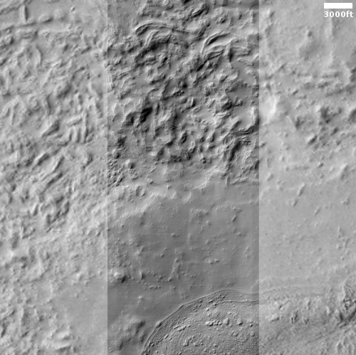
Today’s cool image takes us to the Death Valley of Mars, Hellas Basin, a place I like to call the basement of Mars. The photo to the right, cropped and reduced to post here, was taken by the high resolution camera on Mars Reconnaissance Orbiter (MRO) on September 28, 2020, and gives us another example of the very strange and inexplicable geological formations that are often found on the floor of Hellas.

The picture was taken not as part of any particular research project, but somewhat randomly for engineering reasons. In order to maintain the proper temperature of MRO’s high resolution camera, it must take images in a regular cadence. When large gaps in time occur between requested images, the camera team then picks locations to fill those gaps, sometimes randomly, sometimes based on a quick review of earlier wide angle images.

Sometimes these “terrain sample” images are quite uninteresting. More often they hold baffling surprises.

I think the photo to the right falls into the latter category. Though the terrain covered by the full image is largely flat and lacking in large features, the surface is strewn with perplexing small details.

The light streaks might be dust devil tracks, but why are they light here when such tracks are routinely dark everywhere else on Mars? What formed the many parallel small ridges? What caused the smooth solid patch near the photo’s center top? And why do the ridgelines at the western edge of that patch run in almost a perpendicular direction to the other ridges?

All a mystery, but then the floor of Hellas Basin is filled with such mysteries. Below is a list of some other cool images of the floor of Hellas, all weird and mystifying. Also below is an overview elevation map of Hellas Basin, with darker blue indicating the lowest elevations. The white cross marks the location of today’s photo.
» Read more

Antarctica data adds weight to hypothesis that glaciers shaped Mars

New data from an Antarctica ice core strengthens the hypothesis that the flow of glaciers, not liquid water, helped shape the meandering canyons on Mars.

The data was the discovery of the mineral jarosite deep within the south pole ice-cap. Jarosite needs water to form. Previously it was generally believed it formed in conjunction with liquid flowing water. On Mars, which appears to have lots of jarosite, scientists have struggled for decades to figure out how enough liquid water could have existed on the surface of Mars to produce it.

The discovery of jarosite deep inside the Antarctic ice cap now suggests that it can form buried in ice, not liquid water. According to the scientists,

the jarosite was born within massive ice deposits that might have blanketed [Mars] billions of years ago. As ice sheets grew over time, dust would have accumulated within the ice—and may have been transformed into jarosite within slushy pockets between ice crystals.

From the paper’s conclusions:

The occurrence of jarosite in TALDICE [in Antarctica] supports the ice-weathering model for the formation of Martian jarosite within large ice-dust deposits. The environment inside the Talos Dome ice [in Antarctica] is isolated from the Earth atmosphere and its conditions, including pressure, temperature, pH and chemistry, provides a suitable analogue for similar Martian settings. Dust deposited at Talos Dome is also similar to Martian atmospheric dust, being both mostly basaltic. Within thick ice deposits it is likely that the environment would be similar at Talos Dome and under Mars-like conditions since both settings would contain at cryogenic temperatures basaltic dust and volcanogenic and biogenic (for Antarctic only) sulfur-rich aerosols. … Considering this context, it is reasonable that the formation of jarosite on Mars involves the interaction between brines and mineral dust in deep ice, as observed in TALDICE. This mechanism for Martian jarosite precipitation is paradigm changing and strongly challenges assumptions that the mineral formed in playa settings.

Playa settings are places where there is standing liquid water, slowing drying away.

This result is another piece of evidence that ice and glaciers were the cause of the Martian terrain that to Earth eyes for decades was thought to have formed by flowing water. It also continues what appears to be a major shift on-going in the planetary science community, from the idea of liquid water on Mars to that of a planet dominated by glacial and ice processes.

Back to Mars’ glacier country

Tongue-shaped glacial flow on Mars
Click for full image.

The cool image to the right, rotated, cropped, and reduced to post here, was taken on November 3, 2020 by the high resolution camera on Mars Reconnaissance Orbiter (MRO). It shows what the science team labels a “Possible Tongue-Shaped Flow Feature in Protonilus Mensae.” There is no caption, so I will try to provide.

Protonilus Mensae is part of the long string of chaos terrain that runs about 2,000 miles along the transition zone between the southern cratered highlands and the northern lowland plains at about 30 to 40 degrees north latitude, and includes the other mensae regions dubbed Deuteronilus to the west and Nilosyrtis to the east. This region of Mars I like to call glacier country, because almost every high resolution photograph appears to show glacial features. To get an idea what I mean, take a gander at these past posts, their locations indicated by number in the overview map of Protonilus Mensae below:
» Read more

OSIRIS-REx to make one last observation of Bennu before heading back to Earth

The OSIRIS-REx science team has figured out a way to make one last observation of Bennu and the Nightingale sample return site before heading back to Earth on May 10th.

This activity was not part of the original mission schedule, but the team is studying the feasibility of a final observation run of the asteroid to potentially learn how the spacecraft’s contact with Bennu’s surface altered the sample site. If feasible, the flyby will take place in early April and will observe the sample site, named Nightingale, from a distance of approximately 2 miles (3.2 kilometers). Bennu’s surface was considerably disturbed after the Touch-and-Go (TAG) sample collection event, with the collector head sinking 1.6 feet (48.8 centimeters) into the asteroid’s surface. The spacecraft’s thrusters also disturbed a substantial amount of surface material during the back-away burn.

The mission is planning a single flyby, mimicking one of the observation sequences conducted during the mission’s Detailed Survey phase in 2019. OSIRIS-REx would image Bennu for a full rotation to obtain high-resolution images of the asteroid’s northern and southern hemispheres and equatorial region. The team would then compare these new images with the previous high-resolution imagery of Bennu obtained during 2019.

Getting at look at Nightingale post-sample-grab is critical to better understanding the nature of the asteroid. Knowing how much changed from that contact will tell scientists a lot about the density, interior, and surface of this rubble-pile asteroid.

This last flyby will also give them the chance to assess the spacecraft’s equipment following the touch-and-go sample grab. They want to know if everything still works as designed in order to plan any post-Bennu missions, including the possibility that OSIRIS-REx will rendezvous with the asteroid Apophis in ’29, shortly after the asteroid makes its next close flyby of Earth.

The strange moated mesas of the Kasei Valley on Mars

Overview map

In showing my readers today’s cool image, I want to present it as it is seen by scientists, first from a far distance that with time increasingly zooms in to reveal mysteries on a very human scale.

The overview map to the right essentially gives us the view of Mars as seen by scientists following the Mariner 9 orbiter mission that began mapping the Martian surface in late 1971 after the conclusion of a global dust storm that had hidden its surface initially. As the first high resolution map of Mars, the orbiter revealed numerous puzzling and surprising features, including the largest volcanoes and canyons in the solar system. The orbiter also found that the red planet’s surface was comprised of two very different regions, the northern lowland plains and the southern cratered highlands.

The overview map, covering from about 13 degrees south latitude to about 34 degrees north latitude, shows us all but the southern cratered highlands. The white box in Kasei Valles is where today’s cool image is located. Both Kasai and Valles Marineris represent those giant canyons, all invoking to Earth eyes the possibility of catastrophic floods of liquid water sometime in the past.

Ascraeus Mons is the northernmost of the three giant volcanoes east of the biggest volcano of all, Olympus Mons. All sit on what scientists now call the Tharsis Bulge.

Chryse Planitia, where Viking-1 landed in 1976, is part of those northern lowlands that some scientists believe might have been once had an intermittent ocean sometime in the past. Today’s image is about 600 miles from the outlet into Chryse Planitia.

The geological mystery of all these features demands a closer look, something that scientists have been pursuing now for more than a half century.
» Read more

The pit caves of Mars: Can humans someday live in them?

Four more pits in the Tharsis Bulge on Mars

It has been more than four months since my last report on the pits of Mars. Time to do another.

The collage to the right shows the four different pits photographed by the high resolution camera of Mars Reconnaissance Orbiter (MRO) since October. The links to each image are:

Like almost all the cave pits so far found on Mars, all are in the Tharsis Bulge of giant volcanoes to west of Valles Marineris. The overview map below shows these pits in the context of every other pit in this region that I have featured on Behind the Black.
» Read more

Chinese government gives wrist slap to powerful scientist on fraud and plagiarism charges

In a decision clearing a powerful scientist of charges of fraud and plagiarism in more than sixty papers, several of which have already been retracted, the Chinese government has also allowed that scientist to keep his post as head of one China’s universities.

The Chinese communists did punish him, but in a way that in the long run is mostly meaningless.

Cao [Xuetao, president of Nankai University and an academician at the Chinese Academy of Engineering] will be barred from applying for national science and technology projects, lose his qualification as a scientific expert, and be forbidden from recruiting graduate students, all for 1 year. The notification also ordered him to investigate and correct the papers. It appears he will keep his job as president of Nankai University, one of China’s most prestigious universities. (On Nankai’s English-language website, Cao is also listed as one of the university’s two chancellors.) Cao did not immediately respond to an email requesting comment.

In other words, he keeps his powerful post. To get off so lightly you would almost think he worked for the American FBI and had tried to overthrow a legal election. But then, no, it isn’t the same. The FBI officials who managed the Trump coup have actually seen less punishment. China, as corrupt as its communist government might be, in this case actually managed to administer a tiny bit of justice.

This is the future, as the world’s culture no longer honors law and the truth, but power and authority. And those in power will never be brought to justice, because they are above all those little people who serve them.

This also tells you how little you should trust any results coming from a government scientist. Those results might be real, but before you accept them you better go over them with a fine-tooth comb.

Parker completes 7th solar fly-by, sets new records

The Parker Solar Probe this week successfully completed its seventh close fly-by of the Sun, coming within 8.4 million miles and traveling at almost 300,000 miles per hour.

Nor is that all for 2021:

The spacecraft will make three more progressively close passes to the Sun in 2021 alone, as well as two gravity-assist flybys at Venus in February and October to adjust the trajectory of its orbit. After zipping past Venus on Feb. 20, Parker Solar Probe will again make close approaches to the Sun on April 29 and Aug. 9. Following another Venus gravity assist on Oct. 16, the spacecraft will make an even closer solar pass on Nov. 21, with perihelion just 5.3 million miles from the Sun’s surface.

Because the fly-bys of Venus are shrinking Parker’s solar orbit, the time between solar fly-bys is also shrinking.

The slowly disappearing dry ice cap at Mars’ south pole

The Happy Face crater near Mars' south pole
Click for the 2020 full image.

Cool image time! The photo to the right of two images taken by the high resolution camera on Mars Reconnaissance Orbiter (MRO) was posted as a captioned image by the orbiter’s science team today.

This crater, dubbed the Happy Face Crater because of the shape of the blobby features within it, is located on the south pole ice cap of Mars, about 200 miles from the south pole itself.

Today’s caption noted how these pictures, taken nine years apart, illustrate the change going on at the Martian south pole.

The “blobby” features in the polar cap are due to the sun sublimating away the carbon dioxide into these round patterns. You can see how nine years of this thermal erosion have made the “mouth” of the face larger. The “nose” consisted of a two circular depressions in 2011, and in 2020, those two depressions have grown larger and merged.

While this caption noted the importance of studying these long term changes in order to understand the evolution of Mars’ climate and geology, it did not give the very specific discovery these changes suggest for Mars globally, a discovery that is actually very significant.

The two ice caps of Mars have some fundamental differences, all presently unexplained. The similarities are obvious. Both have permanent caps of water ice that are presently believed to be in a steady state, not shrinking or growing. Both each winter get covered by a thin mantle of dry ice that sublimates away completely with the coming of spring.

The differences are more puzzling, as shown by the maps of the two poles below.
» Read more

1 76 77 78 79 80 271