Evidence of Martian near-surface ice in an unusual location

Evidence of Martian near-surface ice in an unusual location
Click for original image.

Cool image time! The picture to the right, cropped, reduced, and sharpened to post here, was taken on May 27, 2024 by the high resolution camera on Mars Reconnaissance Orbiter (MRO). Labeled merely as a terrain sample, it was likely taken not as part of any specific research request, but to fill a gap in the camera’s picture-taking schedule so as to maintain its proper temperature.

The picture however shows features that help confirm earlier research into the near-surface ice believed to permeate Mars’ middle latitudes. The knobby flat terrain both inside and outside of the crater resembles what scientists have labeled “brain terrain”, an as-yet unexplained geological feature unique to Mars and usually associated with near-surface ice and the glacial features found above 30 degrees latitude.

This 1.4-mile-wide unnamed crater is located at 40 degrees north latitude, so expecting near-surface ice or glacial features here is not unreasonable. The location however is different for other reasons, that make this data more intriguing.
» Read more

0 comments

A real whirlpool in space

A real whirlpool in space
Click for original image.
Cool image time! The picture above, cropped to post here, was taken by the Hubble Space Telescope as part of a survey of nearby galaxies that have what astronomers call an Active Galactic Nuclei (AGN), because the supermassive black hole at the center is devouring nearby material at a great rate and thus producing high energy emissions as it does so.

Many active galaxies are known to astronomers at vast distances from Earth, thanks to the great brightness of their nuclei highlighting them next to other, dimmer galaxies. At 128 million light-years from Earth, UGC 3478 is positively neighbourly to us. The data used to make this image comes from a Hubble survey of nearby powerful AGNs found in relatively high-energy X-rays, like this one, which it is hoped can help astronomers to understand how the galaxies interact with the supermassive black holes at their hearts.

The bottom line is that this spiral galaxy literally is a whirlpool, the entire galaxy spiralling down into that massive black hole in its center. One cannot help wondering why such galaxies don’t end up eventually getting completely swallowed by that black hole.

Or maybe they do, and we don’t see such things because all that is left is a supermassive black hole that emits no light or energy at all, a dark silent ghost traveling between the galaxies unseen and undetectable.

8 comments

Finding beauty on Mars in all the strange places

Overview map

Beauty on Mars
Click for original image.

Cool image time! The picture to the right, cropped to post here, was taken on May 23, 2024 by the high resolution camera on Mars Reconnaissance Orbiter (MRO).

The white dot in the inset of the overview map above indicates the location on Mars, smack dab in the middle of the 2,000-mile-long mid-latitude strip that I call glacier country, because practically every close-up image of this region shows glacial features.

This picture is no exception. The arrows in the inset show the downhill grade, falling about 1,700 feet across the entire inset. That grade is a reflection of the transition that takes place in this glacier country from the cratered southern highlands to the northern lowland plains.

I decided to crop the image at full resolution — showing only a tiny portion — because to my eye these curving linear grooves, produced naturally as Mars’ climate cycles cause glaciers to shrink and then grow repeatedly so that each cycle lays down a new line while squeezing the previous lines, are almost like a work of art. This might be nothing more than a glacier on an alien planet, but nature has caused it to form a very beautiful picture.

2 comments

The massive scale of Mars’ biggest canyon

Overview map

The south rim of Valles Marineris
Click for original image.

Cool image time! The picture to the right, rotated, cropped, reduced, and sharpened to post here, was taken on May 24, 2024 by the high resolution camera on Mars Reconnaissance Orbiter (MRO). Labeled merely a “terrain sample” by the camera team, it was likely taken not as part of any particular research project, but to fill a gap in the picture-taking schedule in order to maintain the camera’s proper temperature.

When the camera team needs to do this, they try to pick interesting targets within the required timeframe. Sometimes they succeed, sometimes not. In today’s example, they succeeded quite well. As shown by the overview map above, this picture captures (as indicated by the rectangle) the top of the southern rim of Valles Marineris, the biggest canyon on Mars and quite possibly the biggest in the entire solar system.

For scale, the drop from the rim to the low point in this picture is about 9,000 feet. That’s a 1,000 feet more than the drop from the north rim of the Grand Canyon to the canyon bottom at the Colorado River. In Valles Marineris however our descent has barely begun. To get to the bottom of the southern canyon here you still need to drop 15,000 more feet, for a total descent of 24,000 feet, an elevation change similar to most of the mountains in the Himalayas.

Nor are you yet at the bottom. If you climb over the ridge of 18,000-foot-high mountains that bisect Valles Marineris at this point, you can drop down even further, to a depth 31,000 feet below the southern rim.

Mount Everest is just over 29,000 feet high, which means if placed inside Valles Marineris is peak would still sit 2,000 feet below the rim.

The photo itself highlights part of the erosion process that formed Valles Marineris. This is the dry tropics, so no water was involved in shaping this terrain for many eons. Instead, what appear to be flows within the hollows is alluvial fill, material that over time breaks off and rolls downhill, filling the slopes below. Erosion will grind this material into smaller particles, so given enough time it flows almost like sand.

0 comments

The North Star has spots!

The spoted surface of Polaris
Click for original image.

Astronomers using an array of six ground-based telescopes have obtained best new data of Polaris, the North Star, including the first rough image of its surface, and discovered sunspots on its surface.

You can read the paper here [pdf]. The image to the right, taken from figure 4 of the paper, shows the surface as seen by the telescopes over two nights in April 2021. Polaris is what astronomers call a Cepheid variable star, which changes brightness on a very precise schedule as its diameter grows and shrinks. In the case of Polaris, that variation is four days long. The star’s brightness itself varies only slightly, and over the decades has even at times appeared to cease its variations.

As the true brightness of Cepheids is very predictable based on their pulse rate, these stars are one of the main tools astronomers use to determine distances to other galaxies. Knowing more about them thus has great importance to cosmological research.

The orbital motion showed that Polaris has a mass five times larger than that of the Sun. The images of Polaris showed that it has a diameter 46 times the size of the Sun.

The biggest surprise was the appearance of Polaris in close-up images. The CHARA observations provided the first glimpse of what the surface of a Cepheid variable looks like. β€œThe CHARA images revealed large bright and dark spots on the surface of Polaris that changed over time,” said Gail Schaefer, director of the CHARA Array. The presence of spots and the rotation of the star might be linked to a 120-day variation in measured velocity.

The researchers plan to take regular images again of Polaris to better track the changes to its surface.

4 comments

What the heck caused these cones to align on Mars?

Another
Click for original image.

Time for another “What the heck?” cool image! The picture to the right, cropped, reduced, and sharpened to post here, was taken on May 23, 2024 by the high resolution camera on Mars Reconnaissance Orbiter (MRO). It shows what the science team labels as “longitudinally aligned cones”.

To my eye the cones visibile in this picture seem more aligned latitudinally, to the east-west, instead of longitudinally, north-south, but the larger view in the inset on the overview map below shows that on a larger scale, the cones do appear aligned in a north-south direction.

Either way, this is one of those photos from Mars orbit that leaves me entirely baffled. The cones and the flow feature that cuts across the middle of the image might be either volcanic or glacial, but it is beyond my pay grade to explain what caused this patch of aligned cones.
» Read more

1 comment

Mining Mars

Mining Mars
Click for original image.

Cool image time! The picture to the right, cropped, reduced, and sharpened to post here, was taken on May 22, 2024 by the high resolution camera on Mars Reconnaissance Orbiter (MRO). The picture’s focus of study is the bright strip running diagonally across the center, which the scientists label as a “linear feature exposure of infrared-bright material.”

This bright strip with all the swirls of alternating light and dark terrain is a fissure about 80 feet deep. What is interesting is that the parallel bright features to the north and south are actually ridges, not depressions, even though there appears to be some resemblance between them all. (Note that the patches of very thin parallel lines are likely ripple dunes sitting on top of the topography.)

So, what created this fissure? And why is its inner surface so strange? As is usually the case, a wider look provides some clues.
» Read more

0 comments

Martian gullies flowing down to a Martian river of ice

Gullies on cliff wall
Click for original image.

Cool image time! The picture to the right, cropped, reduced, and sharpened to post here, was taken on May 16, 2024 by the high resolution camera on Mars Reconnaissance Orbiter (MRO).

The scientists label this as “gullies previously identified in the walls of Harmakhis Vallis.” The gullies are obvious, the series of erosion features on the cliff wall. The cliff itself drops about 2,800 feet from the rim to the floor, and also appears to have internal horizontal layers that the gullies cut through.

What causes the gullies? Planetary scientists have a number of theories, none of which appear to explain the gullies everywhere on the Martian surface. They all appear in the mid-latitudes, where the most glaciers on Mars are found, and appear to be related to ice or frost freeze-thaw processes, with some gullies actually very ancient and formed when the planet’s rotational tilt was significantly different.
» Read more

2 comments

Webb data suggests the possibility of ice and hydrated minerals on surface of Psyche

Using the Webb Space Telescope, astronomers have detected evidence of hydrated minerals and even possibly a very tiny amount of water ice on the surface of the metal asteroid Psyche.

The Webb data point to hydroxyl and perhaps water on Psyche’s surface. The hydrated minerals could result from external sources, including impactors. If the hydration is native or endogenous, then Psyche may have a different evolutionary history than current models suggest. β€œAsteroids are leftovers from the planetary formation process, so their compositions vary depending on where they formed in the solar nebula,” said SwRI’s Dr. Anicia Arredondo, another co-author. β€œHydration that is endogenous could suggest that Psyche is not the remnant core of a protoplanet. Instead, it could suggest that Psyche originated beyond the β€˜snow line,’ the minimum distance from the Sun where protoplanetary disc temperatures are low enough for volatile compounds to condense into solids, before migrating to the outer main belt.”

However, the paper found the variability in the strength of the hydration features across the observations implies a heterogeneous distribution of hydrated minerals. This variability suggests a complex surface history that could be explained by impacts from carbonaceous chondrite asteroids thought to be very hydrated.

You can read the research paper here [pdf]. The actual amount of water possible is at most 39 parts per million and is also an order of magnitude lower than that found on the Moon, which strongly suggests that it comes from outside sources, such as impacts from other asteroids, not from the inherent geological history of Psyche itself.

The uncertainties of this research, which are large, which should be resolved when the probe Psyche, launched last year, reaches the asteroid Psyche in August 2029.

3 comments

Buried peaks in a sea of Martian sand

Buried peaks in a sea of sand
Click for original image.

Cool image time! The picture to the right, rotated, cropped, reduced, and sharpened to post here, was taken on April 13, 2024 by the high resolution camera on Mars Reconnaissance Orbiter (MRO). It shows what the MRO science team labels as “streamlined features”, though that doesn’t seem to me to be the best description.

Granted, the prevailing winds, from the northeast to the southwest, appear to pushing the sand dune fields to the southwest. The dark line — created recently by a dust devil — indicates the wind direction. The mesas, from 100 to 200 feet high, do not however appear very streamlined. Instead, they simply look like they are poking up through this sea of sand and dunes, with the wind able over time to successfully push that sand uphill a hundred-plus feet into the saddle between the mesas.

The overview map below provides some context and possibly an explanation, though not a very conclusive one.
» Read more

0 comments

The strange carbon dioxide ice cap of Mars’ south pole

The strange carbon dioxide cap of Mars
Click for original image.

Cool image time! The picture to the right, cropped to post here, was taken on July 1, 2024 by the high resolution camera on Mars Reconnaissance Orbiter (MRO). The image is labeled simply as a “terrain sample,” which usually means it was taken not as part of any specific research project but to fill a gap in the picture-taking schedule in order to maintain the camera’s proper temperate. When the camera team needs to do this, they try to picture interesting features availabe at that time slot. Sometimes the image is boring. Sometimes it is surprisingly interesting.

In this case the picture is the latter, and certainly quite alien. The curly parallel dark lines appear to be grooves, and seem to have ripple dunes within them, as if the only dust here got trapped in those low spots. It is also possible that the dunes are frozen and ancient, and are only being revealed as the top layer in each groove goes away.

What could possibly explain what we are looking at? The overview map below gives only a clue.
» Read more

1 comment

A galaxy with a ring

A galaxy with a ring
Click for full image.

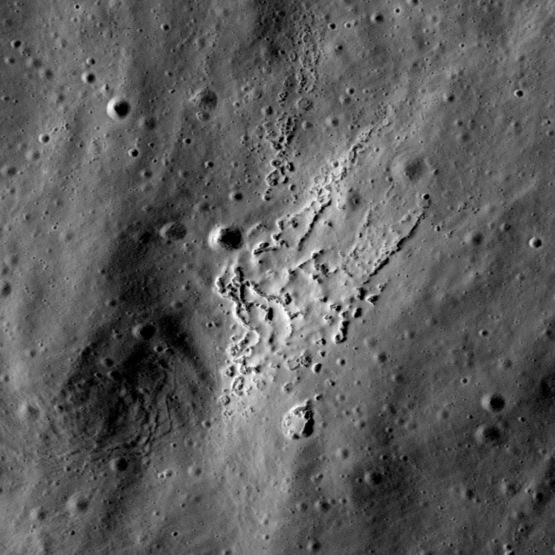
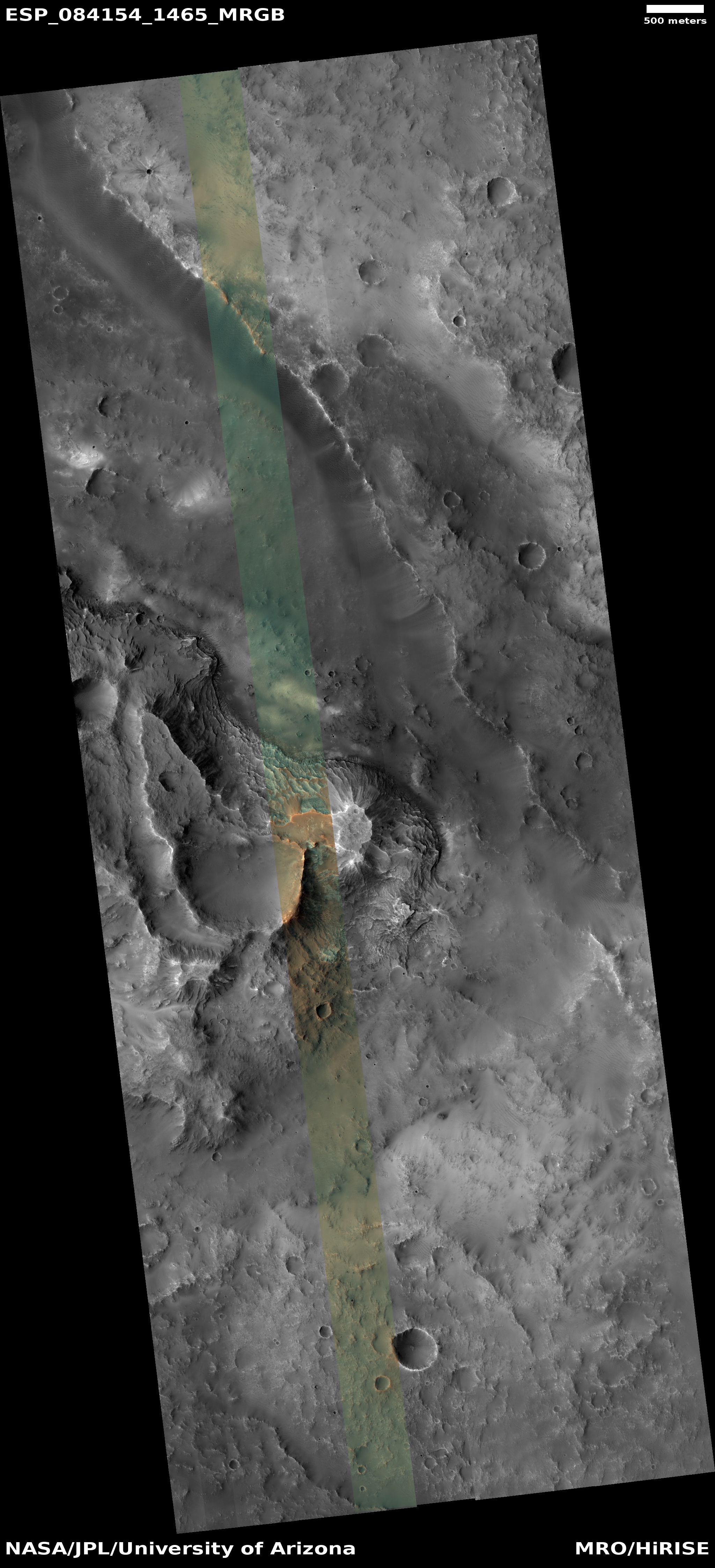
Cool image time! The photo to the right, cropped, reduced, and sharpened to post here, was taken by the Hubble Space Telescope, and appears part of a long term survey of nearby ringed galaxies. From the caption:

MCG+07-07-072 has quite an unusual shape, for a spiral galaxy, with thin arms emerging from the ends of its barred core to draw a near-circle around its disc. It is classified, using a common extension of the basic Hubble scheme, as an SBc(r) galaxy: the c denotes that its two spiral arms are loosely wound, each only performing a half-turn around the galaxy, and the (r) is for the ring-like structure they create. Rings in galaxies come in quite a few forms, from merely uncommon, to rare and astrophysically important!

Lenticular galaxies are a type that sit between elliptical and spiral galaxies. They feature a large disc, unlike an elliptical galaxy, but lack any spiral arms. Lenticular means lens-shaped, and these galaxies often feature ring-like shapes in their discs. Meanwhile, the classification of β€œring galaxy” is reserved for peculiar galaxies with a round ring of gas and star formation, much like spiral arms look, but completely disconnected from the galactic nucleus – or even without any visible nucleus! They’re thought to be formed in galactic collisions.

This galaxy is about 320 million light years away, and is also known as Abell 426. Though astronomers think that these various shapes of galaxies, from barred to lenticular to ringed, are formed from a variety of galactic collusions and interactions with each galaxy’s nucleus, that remains nothing more than an educated guess. The complexity of galaxy evolution, involving billions of years and millions of stars, is barely in its infancy, and requires a lot of assumptions because our observations only involves a mere nanosecond in that grand history.

2 comments

Are these Martian terraced mesas or pits?

Are these Martian pits or mesas?
Click for original image.

Cool image time! The picture to the right, cropped, reduced, and enhanced to post here, was taken on July 2, 2024 by the high resolution camera on Mars Reconnaissance Orbiter (MRO). I have purposely enhanced the contrast to bring out the strangely shaped and terraced features.

What I cannot figure out from any data available to me is whether these terraced features are mesas rising up, or pits descending down. The resolution in the global mosiac of Mars created both from MRO’s context camera and its elevation data is simply not good enough. It suggests these are pits, but the sunlight is coming from the west, which based on the shadows suggest these could be pits or mesas.

In fact, the dark lines that appear to distinguish the terraces might not be shadows at all, but simply darker material that contrasts with the lighter material on each side.
» Read more

4 comments

Another “what the heck?” image from Mars

What the heck is this?
Click for original image.

Cool image time! The picture to the right, cropped, reduced, and sharpened to post here, was taken on April 14, 2024 by the high resolution camera on Mars Reconnaissance Orbiter (MRO), and shows what the scientists simply label as “exposed crater floor materials.”

I label it as another one of my “what the heck?” images, showing features that in some ways defy understanding or explanation. The picture shows a small area of the floor of an unnamed 14-mile-wide crater, with its rim indicated. Though clearly visible in orbital photos, the crater is nonetheless heavily eroded and even appears partly buried, possibly by flood lava.

The complex floor features however are not anything usually seen in flood lava terrains. The terrain colored blue in the color strip likely indicates coarse material like sand or rocks or rough bedrock, while the reddish terrain suggests the surface is heavily coated with dust.
» Read more

3 comments

A frozen bubbly caldron on Mars

A frozen bubbly caldron on Mars
Click for original image.

Cool image time! The picture to the right, rotated, cropped, reduced, and sharpened to post here, was taken on April 11, 2024 by the high resolution camera on Mars Reconnaissance Orbiter (MRO). It shows a nice collection of what the scientists label “irregular ring structures,” interspersed with clusters of small mesas ranging in heights from 13 to 75 feet.

The location is at 27 degrees north latitude, so the presence of near surface ice, which might explain these strange rings, is less likely though not impossible. The stipled nature of the flat ground suggests that near surface ice might be here, resulting in sublimation of that ice and leaving behind a flat but rough surface.

The location however suggests another possibility, which though vastly different in some ways, is almost identical in others.
» Read more

1 comment

Meandering Martian ridges flowing down from crater rim

Meandering Martian ridges
Click for original image.

Cool image time! The picture to the right, rotated, cropped, reduced, and enhanced to post here, was taken on February 9, 2024 by the high resolution camera on Mars Reconnaissance Orbiter (MRO). It shows a good example of the typically rough region inside the southern cratered highlands of Mars.

Note the ripple dunes that fill the low areas. The volcanic ash from Mars’ past volcanic history has become trapped here, with those ripple dunes suggesting the direction of the prevailing winds to the southeast.

The bright areas also suggest there is interesting mineralogy just below the surface. The 100-foot-high mesa near the picture’s top suggests a lot of erosion has occurred here, with its top suggesting the elevation of the surface a long time ago.

The most interesting feature however is the meandering ridge that starts at the lower right and weaves to the upper left.
» Read more

3 comments

Zebra layering in the Martian high southern latitudes

Zebra layering in the Martian high southern latitudes
Click for original image.

Cool image time! The picture to the right, rotated, cropped, reduced, and sharpened to post here, was taken on May 16, 2024 by the high resolution camera on Mars Reconnaissance Orbiter (MRO). The science team labeled it simple as a “terrain sample,” which usually indicates a picture not taken as part of any specific request or research project, but to fill a gap in the photography schedule in order to maintain the camera’s proper temperature.

When such pictures are necessary, the camera team tries to target the most interesting features that will be below MRO during the required time period. In this case they aimed for a north-facing slope, about 340 feet high, made up of a series of terraced layers, distinguished by the sharply contrasting bright flat benches and very dark cliff-faces.

While the cliffs are dark partly because of the sun is coming from the west, putting them in shadow, it is not entirely the cause. Note how the cliffs on the west side of the mound are also dark, suggesting that the darkness is a fundamental feature of the ground itself.
» Read more

0 comments

Webb: Carbon monoxide detected on surface of Uranus’s moon Ariel suggests an underground ocean

The best image of Ariel, as seen by Voyager-2, January 24, 1986
Voyager-2’s best image of Ariel during the
January 24, 1986 fly-by. Click for original.

By doing infrared spectroscopy using the Webb Space Telescope, scientists have detected carbon monoxide (CO) and confirmed extensive carbon dioxide (CO2) deposits on the surface of Uranus’s moon Ariel, with the carbon monoxide suggesting the moon has an underground ocean.

Using NASA’s James Webb Space Telescope to collect chemical spectra of the moon and then comparing them with spectra of simulated chemical mixtures in the lab, a research team led by Richard Cartwright from the Johns Hopkins Applied Physics Laboratory (APL) in Laurel, Maryland, found that Ariel has some of the most carbon dioxide-rich deposits in the solar system, adding up to an estimated 10 millimeters (0.4 inches) or more thickness on the moon’s trailing hemisphere. Among those deposits was another puzzling finding: the first clear signals of carbon monoxide.

β€œIt just shouldn’t be there. You’ve got to get down to 30 kelvins [minus 405 degrees Fahrenheit] before carbon monoxide’s stable,” Cartwright said. Ariel’s surface temperature, meanwhile, averages around 65 F warmer. β€œThe carbon monoxide would have to be actively replenished, no question.”

You can read the peer-reviewed paper here [pdf]. Though there are a number of ways in which the carbon monoxide can be replenished, the scientists think it is coming from an underground ocean. From the paper’s abstract:

The evidence for thick CO 2 ice deposits and the possible presence of carbonates on both hemispheres suggests that some carbon oxides could be sourced from Ariel’s interior, with their surface distributions modified by charged particle bombardment, sublimation, and seasonal migration of CO and CO 2 from high to low latitudes.

This theory however has not been confirmed, and the scientists admit it will take a probe making close observations of Ariel to find out for sure.

Hat tip to stringer Jay for this story.

0 comments

More great hiking on Mars

More great hiking on Mars
Click for original image.

Today’s cool image takes us to another place on Mars where future colonizers will find the hiking breath-taking. The picture to the right, rotated, cropped, reduced, and sharpened to post here, was taken on April 18, 2024 by the high resolution camera on Mars Reconnaissance Orbiter (MRO). The camera team labeled it merely as a “terrain sample,” indicating it was not taken as part of any specific research project request, but to fill a gap in the schedule in order to maintain the camera’s proper temperature. When the MRO team does this, they try to pick interesting sites, sometimes successfully, sometimes not.

In this case the image captured the sharp nose of a 2,100-foot-high mesa which to my eye immedately said, “I want to hike a trail that switchbacks up that nose!” Ideally, the trail would then skirt the edge of the mesa, then head up to the top of that small knoll on the plateau. Though only another 200 feet higher or so, the peak would provide an amazing 360 degree view of the surrounding terrrain.
» Read more

4 comments

A classic spiral galaxy

A classic spiral galaxy
Click for original image.

Monday is always a slow news day in space, so we start the day with a cool image. The picture to the right, reduced and sharpened to post here, was taken by the Hubble Space Telescope of a spiral galaxy about 100 million light years from Earth.

That NGC 3430 is such a fine example of a galactic spiral may be why it ended up as part of the sample that Edwin Hubble used to define his classification of galaxies. Namesake of the Hubble Space Telescope, in 1926 he authored a paper which classified some four hundred galaxies by their appearance β€” as either spiral, barred spiral, lenticular, elliptical or irregular. This straightforward typology proved immensely influential, and the modern, more detailed schemes that astronomers use today are still based on it. NGC 3430 itself is an SAc galaxy, a spiral lacking a central bar with open, clearly-defined arms.

The bright blue indicates areas of star formation, while the reddish streaks indicates dust. The orange/reddish dots above and below the galaxy are distant background galaxies whose light has been shifted to the red because they appear to be moving away from us due to the expansion rate of the universe.

0 comments
1 24 25 26 27 28 55