Lava-filled Martian crater

Lava-filled Martian crater
Click for original image.

Cool image time! The picture to the right, rotated, cropped, reduced, and sharpened to post here, was taken on July 10, 2023 by the high resolution camera on Mars Reconnaissance Orbiter (MRO). It shows the northeast corner of an unnamed 7-mile-wide crater, located near the equator in the dry Martian tropics.

The MRO science team labels this “crater and lava fill”, suggesting that the crater interior is filled with lava material. The nature of that crater floor reinforces this conclusion, as it is relatively smooth and does not have rough aspects of glacial material found in craters in the mid-latitudes. Instead, it looks like a frozen lake of lava that has the peaks of mostly buried features poking up at various spots.

What makes this crater interesting however are the gullies on the northern interior rim. Gullies on Mars are normally thought to be associated with some water-frost-ice process, probably seasonal, where the thaw-freeze cycle causes small collapses and avalanches. Yet, this crater is almost at the equator, in a very dry region where no evidence of near-surface ice is found. Gullies here suggest the hypothesis for explaining the gullies on Mars have not quite solved the mystery.
» Read more

1 comment

Thick windblown ash in Mars’ largest mountain region

Thick windblown ash near Mars' largest volcano
Click for original picture.

The cool image to the right, rotated, cropped, reduced, and sharpened to post here, was taken on September 1, 2023 by the high resolution camera on Mars Reconnaissance Orbiter (MRO), and shows what the scientists label as “Erosional Features on Olympus Mons.”

What is eroding? Based on the picture itself the first guess is volcanic ash, as these features strongly resemble the many features seen in the Medusae Fossae Formation, the largest volcanic ash field on Mars — about the size of the subcontinent of India.

Medusae however is many thousand miles away, and is not apparently related to any specific volcano. These features are instead directly linked to Olympus Mons, the largest known volcano in the solar system. However, much of the terrain for many hundreds of miles around Olympus is covered with flood lava, which was deposited and hardened quickly to form smooth featureless plains that have resisted much erosion over the eons. Here the terrain is clearly eroded, which suggests that if the material here is volcanic, it was laid down not by flood lava but by falling ash that got compressed but was easily friable and could be blown away by the winds of Mars’ thin atmosphere.
» Read more

0 comments

Close-up of Helene, one of Saturn’s many many moons

Helene, as seen by Cassini in 2011

Cool image time! Though the Saturn orbiter Cassini is long gone, having been sent into Saturn’s atmosphere to burn up in 2017, its image archive of magnificent pictures is still available to peruse. To encourage others to do so, NASA today issued a series of press releases, listing the spacecraft’s top ten pictures from 2011, 2012, 2013, 2014, and 2015.

The picture to the right, cropped, reduced, and sharpened to post here, comes from the 2011 collection and was taken on June 18, 2011. It shows a close-up of 21-mile-wide Helene, one of Saturn’s many many moons and only discovered in 1980. Back in 2010 I featured another Cassini image of Helene, but that picture did not reveal the small surface features seen in the photo to the right.

The light and dark streaks probably indicate dust flowing downhill on the surface. Though the gravity of this object is tiny, it will be enough for dust to act like almost like a liquid, flowing down grade and then pooling in the central pond at the lowest point near the center of the picture. That process is so much like liquid flowing that it appears to have even eroded gullies on slopes near the top and bottom of the picture.

Side note: NASA’s “Science Editorial Team” also issued a press release today that falsely and ignorantly claimed these releases were “to celebrate 10 years since arriving at Saurn,” implying that Cassini arrived in 2013 and is still functioning.

The problem is that Cassini arrived in orbit around Saturn in 2004 and as I noted above ended its mission in 2017. It thus appears that the NASA Science Editorial Team is unable to do even one five-second web search to find out what really happened.

Just another data point indicating the dark age we now live in.

3 comments

Mars’ giant sinkholes

The floor of one of Mars' giant sinkholes

Cool image time! The picture to the right, rotated, cropped, reduced, and sharpened to post here, was taken on June 27, 2023 by the high resolution camera on Mars Reconnaissance Orbiter (MRO). It shows a small section of the floor and northern slope of Hebes Chasma, one of the many very large enclosed pits that can be found to the north of Valles Marineris, the largest canyon in the solar system. Though Hebes seems small next to the 1,500 mile long Valles Marineris, it still is 200 miles long by 80 miles wide, and could easily fit a half dozen Grand Canyons within it.

For example, the Grand Canyon is from 4,420 to 5,400 feet deep, hiking down from the south and north rim lodges respectively, which sit about ten miles apart. On this picture, the peak on the right sits about 5,300 feet above and only about 3.8 miles from the low spot on the bottom left, which means this one small picture encapsulates the Grand Canyon. And yet, the northern rim of Hebes sits another 21,000 feet higher and twelve miles away. And the entire chasma itself extends 50 miles to the west, 150 miles to the east, and 50 miles to the south.
» Read more

0 comments

Striped terrain on Mars

Overview map

Striped terrain on Mars
Click for original image.

Today’s cool image will be a mystery with the answer below the fold. Before you look at the answer, however, you must try to come up with your own explanation for the picture to the right, cropped to post here, that was taken on September 25, 2018 by the high resolution camera on Mars Reconnaissance Orbiter (MRO).

What we see in this picture is what looks like a striped terrain, alternating bands of light and dark. What caused the bands? Why the different colors?

The overview map above provides some clues. The white rectangle inside Juventae Chasma near the map’s center marks the area within which this picture was taken, though the picture to the right covers only about a pixel inside that rectangle.

Can you guess what these stripes reveal, from this little information? For this quiz to work you must make a guess, but be prepared to be wrong and quickly reassess your conclusions. Such is the real scientific method, so rarely taught now in schools.
» Read more

2 comments

Martian ice sheets sublimating like peeling paint?

Overview map

Martian ice sheets resembling paint peeling
Click for original image.

Cool image time! The picture to the right, rotated, cropped, reduced, and sharpened to post here, was taken on September 19, 2023 by the high resolution camera on Mars Reconnaissance Orbiter (MRO).

The features are described as “ribbed terrain” in the label. To my eye they more resemble flakes of peeling paint, most especially the mesas in the lower left. On the full image there are many more examples that resemble old paint peels, barely attached to the wall.

The white dot on the overview map above marks the location, deep inside the 2,000-mile-long strip in the northern mid-latitudes I dub glacier country, because everything seems covered by glacial features. This location is at 42 degrees north latitude, where plenty of near-surface ice features are found on Mars.

At first glance it looks like the top “paint-peel” layers to the south have been slowly sublimating away, leaving behind the smooth plain to the north. The problem is that this smooth area in the full image actually appears to be a glacial ice sheet of its own, filling all the low areas between mesas.

In other words, we are probably looking at layers and layers of ice sheets, each created during a different Martian climate cycle, caused by the wide swings of the planet’s rotational tilt, or obliquity.

The location is within Arabia Terra, the largest transitional zone on Mars between the northern lowland plains and the southern cratered highlands. Thus it sits above the glaciers that fill the lower regions of chaos to the north. What we have here is terrain that will eventually become chaos terrain, as the narrow faults and cracks are slowly widened into canyons by the cycles of glacial activity.

0 comments

Ancient volcanic vent on Mars

Volcanic vent on Mars
Click for original image.

Cool image time! The picture to the right, rotated, cropped, reduced, and sharpened to post here, was taken on May 28, 2023 by the high resolution camera on Mars Reconnaissance Orbiter (MRO).

The picture label describes it as a “Low Shield Vent and Pit Northeast of Arsia Mons,” suggesting these depressions are volcanic in nature. We know the pit in the lower left is not an impact crater because it has no raised rim of ejecta. Instead, it looks like a collapsed sinkhole, formed when the ceiling above a void could no longer support its weight. Similar, the trench to the northeast is aligned with the downhill grade to the northeast, with its features suggesting a vent draining in that direction.

The ample dust inside the trench and pit suggest that it has been a very long time since this vent was active. Research suggests volcanic activity last occurred in this region from 10 to 300 million years ago, so that gives us a rough estimate of this vent’s age. Since then any dust that is blown into it will tend to become trapped there.
» Read more

0 comments

Webb: Needles scattered near the center of the Milky Way

Needles in space
Click for original image.

Scientists today released a new false-color infrared image taken by the Webb Space Telescope of a region about 300 light years from the center of the Milky Way, dubbed Sagittarius-C. That picture is to the right, cropped, reduced and sharpened to post here. The blue or cyan regions are ionized hydrogen clouds, and with this image were revealed to be much more extensive than expected. The orange blob near the center is a densely packed cluster of protostars, the starlight blocked by the cloud of material.

The most interesting feature however are the needle-like structures within that ionized hydrogen, oriented in all directions in a manner that looks completely random. Though such needles have been seen previously, the data here is far more detailed, and might eventually help astronomers figure out what the heck these features are and what caused them.

5 comments

The southernmost extent of Mars’ youngest lava flood event

The southernmost edge of Mars' youngest lava event
Click for original image.

Cool image time! The picture to the right, rotated, cropped, reduced, and sharpened to post here, was taken on August 24, 2023 by the high resolution camera on Mars Reconnaissance Orbiter (MRO).

Labeled “flow margin in Elysium Planitia,” it shows the very edge of what scientists believe was the most recent large lava event on Mars, dubbed the Athabasca Valles, that is thought to have occurred only 600 million years ago. In only a matter of weeks the fast flowing lava covered a region about the size of Great Britain. What we see here is the southernmost edge of that flow, with the smooth terrain on the west an older lava flood plain, covered by the new flood lava from Athabasca on the east.

The polygon cracks likely indicate cracks that formed during the hardening process (like the polygon cracks in drying mud). Hot lava then pushed up from below to form the ridges. It is also possible the ridges are what scientists call “wrinkle ridges,” formed when material shrinks during the drying process.
» Read more

1 comment

Jupiter’s Great Red Spot continues to shrink, possibly to its smallest size ever measured

Jupiter, as seen by Hubble in 2020
A 2020 Hubble picture of Jupiter.
Click for full image.

Long term data from numerous observatories shows that the Great Red Spot on Jupiter, the largest and longest lasting storm in the solar system, has been continuously shrinking for decades, and appears approaching this year its smallest size ever measured.

Despite so many factors working to keep it “alive” the Spot may be in need of life support. It’s been shrinking for decades. In 2012 the rate of shrinkage abruptly accelerated, something many amateur observers have commented on since that time. Several years later, while still shrinking in diameter, it expanded in latitude becoming more circular. Now it’s narrowed again and continues to diminish in both axes. This observing season I’ve been struck by the Spot’s unusually small size. That, along with its pale pink color and turbulent environment, have made it less obvious than ever.

…Using the WinJUPOS program and one of his recent high-resolution images, Peach measured the Great Red Spot’s diameter on November 6, 2023, at 12,500 kilometers or about 7,770 miles across. If confirmed it would make this season’s GRS not only smaller than the Earth (12,756 kilometers or 7,926 miles across) but the smallest size in observational history. A British Astronomical Association Jupiter section bulletin on October 30th described it as “the smallest it has ever been.” That’s a far cry from the late 1800s when the Spot ballooned to 41,000 kilometers (25,500 miles) β€” big enough to swallow three Earths with room to spare. Now it can barely contain one!

No one knows if this shrinkage is merely a normal long term fluctuation, or a sign that this many-centuries-old storm is finally dissippating. When it comes to the solar system’s gas giants, their size and long orbits make any firm conclusion difficult in only a few centuries of observation. To understand them properly will likely require thousands of years of observations, covering many orbits and seasons.

7 comments

Lava/ice eruptions on Mars

Lava/ice eruptions on Mars
Click for original image.

Cool image time! The picture to the right, cropped, reduced, and sharpened to post here, was taken on August 1, 2023 by the high resolution camera on Mars Reconnaissance Orbiter (MRO). Labeled by the science team as showing “possible lava-ice interaction,” the photo features some pimply-looking mounds that, though round like craters, sit above the surrounding landscape like small volcanoes.

That these are likely not ancient pedestal impact craters that now sit higher because their material is packed and can resist erosion is illustrated by the bridge-like mound in the lower right. This mound was likely once solid, but its north and south sections have disappeared, either by erosion or sublimation. If formed by an impact the mound would have had a depression in its top center, and would have only eroded outside the rim.
» Read more

0 comments

Intuitive Machines will attempt to launch 3 lunar landing missions in 2024

South Pole of Moon with landing sites

According to the company’s CEO, Intuitive Machines is pushing to fly two more Nova-C lunar landing missions next year after its first is launched by SpaceX on January 12th and hopefully lands successfully near the Moon’s south pole on January 19th.

Intuitive Machines is working on two more Nova-C landers for its IM-2 and IM-3 missions, also carrying NASA CLPS payloads. The company has not announced launch dates for those missions, but Altemus said he hoped both could take place by the end of 2024.

β€œWe are planning three missions in 2024,” he said, which will depend in part on NASA’s requirements as well as orbital dynamics. Landings at the south polar region of the moon, the target for IM-2, are linked to β€œseasons” where lighting conditions are optimal for lander operations. IM-3, he said, would happen β€œa few months” after IM-2.

Though Nova-C will launch after Astrobotic’s Peregrine lander (launching on ULA’s Vulcan rocket), it will get to the Moon quickly, and will attempt its landing first. If successfully it will therefore be the first private payload to do so.

The company’s ambitions for 2024 are laudable, but depend so entirely on everything going perfectly it will not be surprising if they do not pan out. Nor will it reflect badly on the company if just one mission flies in 2024. Landing a robot on another world is hard. For private companies to do it is harder.

0 comments

The caldera wall of a Martian giant volcano

The caldera wall of Pavonis Mons
Click for original image.

Cool image time! The picture to the right, rotated, cropped, reduced, and enhanced to post here, was taken on June 8, 2023 by the high resolution camera on Mars Reconnaissance Orbiter (MRO). It shows the top half of the northwestern interior wall of the central caldera of Pavonis Mons, the center volcano in the string of three giant volcanos found in Mars’ equatorial regions.

The elevation change from the top to the bottom of this picture is about 7,000 feet, though this covers only half the distance down to the floor of the caldera. The picture was taken as part of a survey of this caldera wall.

Volcanic activity here is thought to have ended more than a billion years ago. Thus we are looking at relatively old terrain that has had many eons to be reshaped since the last eruption.
» Read more

3 comments

The strange craters in the high northern latitudes of Mars

The strange craters in the Martian northern lowlands
Click for original image.

Cool image time! The picture to the right, rotated, cropped, reduced, and enhanced to post here, was taken on August 22, 2023 by the high resolution camera on Mars Reconnaissance Orbiter (MRO). I have also inserted data from a July 28, 2008 context camera image into the blank strip that now exists in the center of high resolution camera images due to the failure of one sensor.

This photo is what the camera team calls a terrain sample, and was probably taken not as part of any specific request but to fill a gap in the camera’s schedule in order to maintain its proper temperature. When the camera team does this they try to find locations that either have not been observed in much detail previously or have interesting features. In this case the team accomplished both. The interesting features are the two pedestal craters, both surrounded by splash aprons. Neither has been observed in high resolution previously, and the context camera has only taken two pictures of this location in total.
» Read more

0 comments

Strange meandering ridge amidst Martian glaciers

Overview map

Strange meandering ridge in glacier country

Cool image time! The picture to the right, cropped, reduced, and sharpened to post here, was taken on June 21, 2023 by the high resolution camera on Mars Reconnaissence Orbiter (MRO). Its focus is the meandering ridge in the center of the picture, which the scientists intentially describe vaguely as a “ridged flow-like feature”.

The elevation difference between the high and low points within the picture is about 500 feet, though most of that slope occurs in the lighter terrain on the right. The darker area where the ridge is located has no clear elevation trend, though there are hints of depressions and rises within it.

The yellow dot on the overview map above marks this location, deep within the chaos terrain dubbed Deuteronilus Mensae, on the western end of the 2,000 long northern mid-latitude strip I dub glacier country, because practially every image from there shows glacial features.

To underline this fact, the red and white dots mark previous cool images from 2020 and 2021, with the first showing an eroded glacier and the second glacial ice sheets.

The mesa to the east of this picture rises more than 6,000 feet to its peak, as indicated by the black dot. This is also the highest point for this entire grouping of mesas. All are surrounded by a single large apron of material, likely a mixture of alluvial fill and ice.

What however caused the narrow ridge in the picture above? Is it ice or bedrock? If ice why is it so different than the glacial material that seems to surround it? If bedrock, it suggests it is instead an ancient inverted channel created when that ridge was a canyon through which ice or water flowed, compacting the canyon floor. When the terrain around it eroded away it was more resistent and became a ridge instead.

I have no answer. The colors suggest the ridge is rock, not ice, but that is not conclusive.

0 comments

The grand Valles Marineris of Mars

The grand canyon of Mars
Click for original image.

Time for another cool image of the grand canyon of Mars, Valles Marineris. The picture to the right, rotated, cropped, reduced, and sharpened to post here, was taken on May 24, 2023 by the high resolution camera on Mars Reconnaissance Orbiter (MRO). It shows a small section of the floor of this gigantic canyon, where orbital data has detected light-toned materials. From the caption:

Many of the Valles Marineris canyons, called chasmata, have kilometer-high, light-toned layered mounds made up of sulfate materials. Ius Chasma, near the western end of Valles Marineris, is an exception.

The light-toned deposits here are thinner and occur along both the floor and walls, as we see in this HiRISE image. Additionally, the sulfates are mixed with other minerals like clays and hydrated silica. Scientists are trying to use the combination of mineralogy, morphology, and stratigraphy to understand how the deposits formed in Ius Chasma and why they differ from those found elsewhere in Valles Marineris.

The picture however gives no sense of the monumental terrain that surrounds it.
» Read more

0 comments

Martian lava that buried a crater

Martian lava flow through crater
Click for original image.

Cool image time! The picture to the right, rotated, cropped, reduced, and sharpened to post here, was taken on June 24, 2023 by the high resolution camera on Mars Reconnaissance Orbiter (MRO). It shows a lava flow that cut through an older 2-mile-wide crater, mostly burying it as it burst through the crater’s southwest and northeast rims. From the caption:

A lava channel extends from the feature and continues 60 kilometers to the northeast, growing deeper along its path. The circular formation is likely an eroded impact crater whose walls have been breached by the lava as it surrounded the rim and then infilled the crater. Alternatively, it could represent the location of a volcanic vent that sourced some of the lavas that formed the channel.

» Read more

2 comments

Galaxies within galaxies within galaxies

Galaxies within galaxies
Click for original image.

Time another cool galaxy image! The picture to the right, cropped, reduced, sharpened, and annotated to post here, was taken by the Hubble Space Telescope as part of a survey project of galaxies where past supernovae had occurred. From the caption:

The location of this faded supernova was observed as part of a study of multiple hydrogen-rich supernovae, also known as type II supernovae, in order to better understand the environments in which certain types of supernovae take place.

Though the picture’s resolution was reduced to post here, I have also included insets at the full released resolution of three of background galaxies, one of which (on the uppermost right) appears to have a second smaller galaxy either associated with it or is another background galaxy even farther away. Such background galaxies are always seen Hubble images, which starkly tell us that the universe is far vaster than we can imaging, with more stars than we can conceive.

The galaxy featured here is interesting in its own right. Though it appears to be a spiral galaxy, its arms are very indistinct, suggesting that is sits between that of an elliptical galaxy (no arms, just a cloud of stars) and a spiral (with well-defined arms).

3 comments

Ingenuity completes very short 65th flight

Overview map
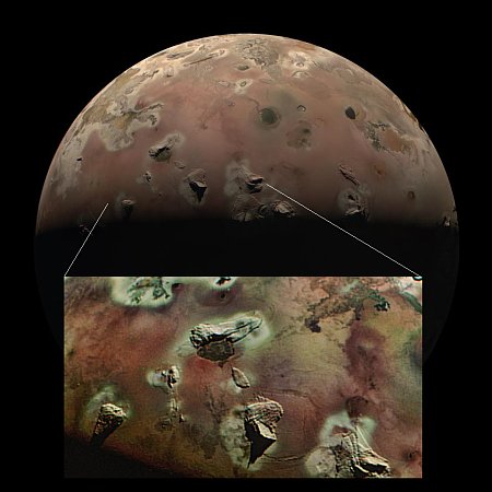
Click for interactive map.
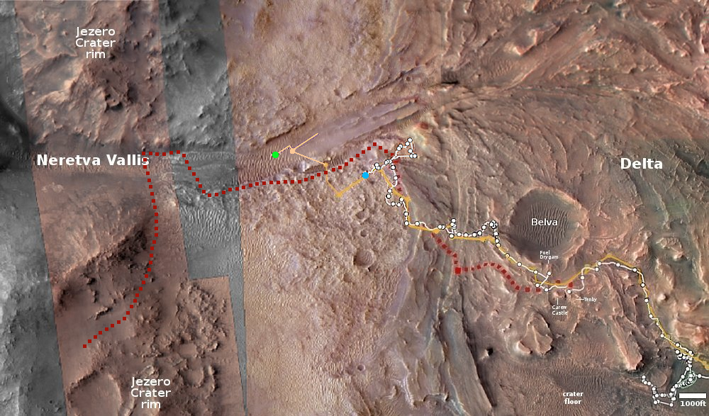
Ingenuity yesterday completed a very short 48 second flight that shifted its position only slightly to the west, by about 23 feet. The distance, time, and highest elevation (33 feet) matched the flight plan exactly.

The green dot on the overview map above indicates its present position, with the blue dot marking Perseverance’s location. This particular flight was so short that it actually fits entirely within that green dot. Furthermore, the helicopter’s next flight, scheduled for today as well, is intended to also only reposition the helicopter, but even less so, moving only two feet or so sideways while rising only ten feet.

It appears the engineering team is preparing the helicopter for the upcoming solar conjunction, when the Sun will be between the Earth and Mars and no communications will be possible for several weeks. Such conjunctions occur about every two years, with this one beginning on November 6th and lasting until November 29th. Getting the helicopter in the right spot during that down time will increase the chances for regaining communications afterward. Since Perseverance acts as a relay station, Ingenuity must get placed in a spot where there is a direct line of communications, blocked by no objects or intevening rise in land.

Note that all the Martian rovers and orbiters are preparing for conjunction right now.

0 comments

Mars geology that only makes sense by digging deeper

Not-so baffling Martian geology
Click for original image.

Today’s cool image is a perfect example of why nothing in science research should ever be taken at face value, without digging a bit deeper. The picture to the right, rotated, cropped, reduced, and sharpened to post here, was taken on October 5, 2023 by the high resolution camera on Mars Reconnaissance Orbiter (MRO).

First an important technical point. Though the electronics unit for one of the camera’s color filters is still not working — causing a blank strip down the center of all black & white images, the camera team has gotten around this problem by inserting in that strip other color filter data, thus creating a complete image as you see to the right. This work-around means that MRO’s capabilities, though showing signs of age, will continue almost as good as before.

As for the image itself, when I first looked at it, I was baffled by the striking contrast between the mottled and rough ground in the lower left, and the almost featureless and smooth terrain everywhere else. Why this sudden transition? What could cause it? That inexplicable contrast demanded I post it as a cool image.
» Read more

1 comment
1 31 32 33 34 35 55